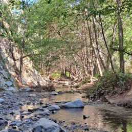
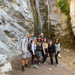
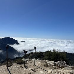
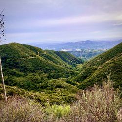
Gabrielino Trail Photos


You might also consider
More like Gabrielino Trail
Recommended Reviews - Gabrielino Trail
Start your review...

Reviews With Photos


I was looking for a new trail to hike that isn't too far away from me. I found this trail on the All Trails app since I wanted to hike in a well shaded area. I would have to say this is my new favorite hike. I am not a hardcore hiker and wanted to stroll on some paved/dirt trail with shade and to turn back when I start feeling tired. We came here on a Sunday morning and there is a very small parking or nearby street parking. The trail had families, kids, dogs, and even horses! I was delighted to learn and see that the Pasadena Police Department patrols the trail on a horse!

Great hike! 8.2 miles total to and from the dam with only about 650 feet elevation gain total. It took me 3 hours total but I wasn't in a rush and the return trip was an hour of that since it's all slightly downhill on the way back. You will need to cross the stream a total of 18 times. 7 of those are man made bridges you could drive a car across and the rest are rocks or logs placed down to cross over. Only 3 of the crossings I had to get my feet wet as there was no other option, but it was only 3-4 inches deep at max and we have had a lot of rain recently in mid Feb 2022. It's a beautiful hike that follows parallel to the running stream, with tons of shade, and it's dotted with all sorts natural and man made landmarks. At one point I saw an old 50s era car half way up the mountain that had to have fallen from the Angels Crest Highway above long ago (what a fall!). Gould Mesa is halfway to the Dam so use that as your halfway point. There were a few mountain bikers resting there and even two campers setting up for the night so it was busier at that section than I expected considering I started my hike at 8AM. The Paul Little campsite is right at the Dam so once you see the last campsite area you know you have arrived. In terms of parking there are two options: the lot on Windsor is about a mile from the trailhead and not my suggestion. Best place to park is near the entrance to JPL where the trailhead starts. There is enough space for hundreds of cars so it should never be full there. I would recommend! Hardest part is the distance and impossible to get lost since you are in a narrow canyon and pretty much just have to follow the water to the source.

Really enjoyable trail walk/light hike. Not particularly steep at any point, though there are a few river crossings that have stone hopping and tree walking options. Nice views. Some tree coverage as you get further down the trail, though out in the open in the early part. Great for families. Plenty of folks do this trail walk with their kids. Also great for biking. Well-trafficked trail over the course of daylight hours. Never been on it feeling isolated, so it's not 'that' type of trail. But at the same time, it doesn't feel like you're right in LA as you get about a mile or two into the walk. Bring your camera. Might see some wildlife if you're lucky as well - woodpeckers, raccoons, a black bear.

This trail sees heavy traffic throughout the year. It has a bunch of shade from the surrounding trees and requires you to cross through small streams. It is about 8 miles out and back. There is a mix of trail users between hikers, bikers, and horses. The majority of the trail is wide and open but there are small sections of single track. It is a relatively flat trail and simple. The destination of the trail goes to a dam where there's a small waterfall. Be aware of loose rocks and fallen branches due to heavy rainfall


This was a pretty cool trail! I love when you can mix an outdoor adventure with some old ruins or in this case old NASA testing grounds! My strava stats rated hiking from the car to the dam and back: Hike on 8/15/2021 Start time 7:14 AM(It was really hot by the time we finished.) 9.37 Miles 563 ft elevation gain Moving Time: 3:17:38 Avg Speed 2.8 mph This was a good easy hike. What I loved is that it was dog friendly and had tons of shade. This is an absolute must for hikes during mid-August when the sun is blazing. There were around 5 creek crossings but plenty of rocks to stabilize on and not get too wet in the process. This trail is also frequented by mountain bikers so just be mindful of trail manners and stepping aside when they come by. There are outhouses about half way into the hike however you will need to bring your own TP or tissue paper as they do not seem well maintained...and the smell....I'll leave it that! HA! There are also trash cans along the hike....please please please clean up after yourself! Leave no trace. My favorite part of the trail was the dam at the end. It had a cool US 1942 engraving at the top with a beautiful pool at the bottom which our pups thoroughly took advantage of to cool off in! Tip: keep your eyes out for the tree with the hole in the bottom and the gnome/elf! :)

Loved it! My first proper hike since I've been in la! Don't judge me! You do have to walk around 3/4 mi before you get to the trails or where they start to split off, but it's worth it. The views are absolutely amazing. When I went last week they still had fire hazard signs up, but everything was copacetic. I saw a fair amount of people in passing, but I felt like I was alone most of my hike, which was nice. Everyone I did pass was respectful and some spoke. My navigation directed me to the wrong place to park. It's actually at the end of the street on the left. It was also cool to see the jpl facility. Bet some cool shit goes on in there! The views were amazing, it was an awesome time. I'll def be going back as I enjoyed my hiking experience

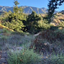
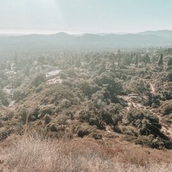
To walk in nature is a miracle in itself. Gabrielino Trail is a 10 mile heavily trafficked out and back trail in Altadena that features beautiful wild flowers, trees, creeks and animals. The trail's topography was easy and well maintained and is accessible year-round with an elevation gain of 954 feet. It has multiple shallow creeks throughout the trail but there are logged bridges to cross them. Careful not to fall but you can definitely step on the stones. Moreover, this trail is very popular among mountain bikers, families, dogs, kids and hikers. Sometimes you'll see horses. The entire trail was relatively flat with very little elevation; it's perfect for a novice hiker or simply want a cardio workout. There are plenty of shades throughout the trail and cool breeze from the creek. Hikers were friendly and respectful; most women that I crossed path have greeted/waved at me on their own volition. Parking (lot and street) was easy. Overall, I enjoyed hiking this trail and highly recommend it.

Yippeee!!!! I finally made it to the Gabrielino Trail/aka JPL Trail for the first time! Thank goodness my friend and awesome Yelper Mel D. likes to hike new trails and dine at new restaurants, so we've been taking turns selecting places we want to go hiking that aren't too far from our respective homes. Then we usually find a new place to go grab lunch that isn't too far from where we've just gone hiking. Mel lives close to Griffith Park and the Hollywood Hills, so every other week we tackle a trail over in her neck of the woods. I live right next to the Angeles National Forest, so I have been choosing among the thousands of trails nearby. A good book to buy is called "Trails of the Angeles". It lists all the trails and campgrounds with a lot of historical facts which is really interesting. Today, Mel met me at my house and we carpooled the four miles to the trail in Altadena with great directions I obtained online from Dan's Hiking Pages at: www.simpsoncity.com/hiking/arroyoseco.html Personally, I love Dan's tips and directions, but my sister-in-law, who is an avid hiker, tweaked Dan's instructions a bit. Dan recommends parking by the intersection of Windsor and Ventura, but then you have to walk about about a half mile with very little shade in the Arroyo Seco wash next to JPL and their huge eastern parking lot. Please follow my instructions if you want to stay in the shade. Directions to Trail: * From the I-210 Foothill freeway exit at Windsor Avenue/Arroyo Blvd. * Drive north on Windsor about .75 miles to where the road curves to the right. * Turn right on Ventura. Go down Ventura a couple blocks. * Turn left on Casitas - Go north up the street until you see slow zone signs on the road. * Turn left on Altadena Drive - Drive to the end of the street and park. * Take trail to the right - You will go down a steep, rocky hill so poles come in handy. Print out Dan's tips from the website above for more directions on where to turn at various forks in the trail. You won't see the Gabrielino Trailhead sign unless you follow his instructions completely and park by the Ventura/Windsor intersection. We entered the trail about a quarter mile past the marker, so we did not see the sign. Trail Highlights: * Lots of shade, so even on a 80 degree day you'll stay comfortable. * Lots of water if you like the sound of running water and crossing it using logs and rocks. * Well travelled by JPL workers, joggers, hikers, dog walkers, mountain bikers and horseback riders. Yes, you will see horse droppings on occasion. Get a grip people. It's not the end of the world. * Campgrounds with outhouses, picnic benches and shade. The Gould Mesa Campground was a nice little spot to take a break if you so choose. More up the trail. Important Notes: * A good way to keep track of how far you've gone is a ap called Map My Hike. It will also give you details on elevation gains and losses as well as time elapsed and calories burned. It told me I burned 1,000 calories, so I splurged on a burger and fries for lunch. After stepping on the scale the next day I gained 1/2 pound which totally blows. Note to self: Just order a salad next time. * You can go all the way up to Oakwilde Campground, but that will be a 9 mile hike roundtrip. * If you want to go all the way up to Switzer's it will be 8 miles to get there or a 16 mile roundtrip. You can always park a car a the top if you and your hiking buddy both bring your car. A lot of the mountain bikers do this. Park on the top at Switzer's and leave a car down by JPL or Hahamongna Watershed Park. I rode down this way on a mountain bike years ago and that's a lot easier than going up. There are a lot of stream crossings. See my photos. * Bring lots of water, a picnic lunch for all the nice picnic areas and poles to aid you with stream crossings. * There were bugs, so bring some bug spray or use your poles to beat them off. That seemed to do the trick for us. * There is a nice little restaurant a couple miles away in Altadena called Fair Oaks Burger if you didn't have time to pack a lunch. I got a delicious avocado burger, fries and a drink for $6.50. They also have Mexican food and Chinese food.

My friends and I arrived to this trail around 7:00AM and it was packed with people due to different cross country/track and field people running on the path. But it wasn't too bad having that many people running by since my friend's and I were having a bit of trouble figuring out which path to take since there are a couple of forks in the road that would lead us astray from the path. Make sure to watch out for bikers too. So you start on a paved road for awhile and eventually pass the JPL on your left. The path splits into a curved road leading down to a parking lot to the left and the other path goes up. Take the right path and keep going on the paved road passing over a few bridges. Eventually there is a fork in the road with a sign. if you want to stick to the Gabrielino Trail, go to the left. Keep walking through dirt roads that very from wide to narrow and some of the path is a bit rocky so make sure to watch your step! There are parts when you do have to pass over water via rocks and logs. When you pass the big campsite there (a bit further down from a sign saying that you are entering the Angeles National Forest) you may be greeted some nice volunteers that will offer assistance with first aid and provide you with free water. If you decide to keep walking pass the site, you will be about 2 miles or so from reaching the waterfall at the end of the trail. Again you will be facing paths that are narrow, crossing over water, and rocky areas, but eventually there will be a part where it's sort of like a fork in the road since there is a rocky wall in the middle. Go to the right of that wall and keep going cause you are almost there! When my friends and I eventually got to the end, there was definietly water coming down. We each decided to get under the waterfall for pictures and it was definietely fun, so make sure to bring extra shirts or a towel at least. The path in total was about 7.50 miles round trip and I enjoyed the sights and sounds of being one with nature. Definitely think we will try out another path next time!

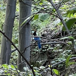
We chose this hike because we were working with a limited amount of time and needed something close and short. We also selected this hiking trail due to the birding aspect. Before even parking, we spotted a lost baby coyote wandering around near the residential neighborhood. The parking lot was full, lots of cyclists so we parked on the street. We spent a couple hours out here and stuck to the path closest to the stream. We spotted a few blue jays, hawks and woodpeckers. I didn't have my new bird book with me and I'm a total newbee and being a birding nerd so I won't bother even attempting to classify the others we saw. I'm actually waiting for Spring when I'm sure there will be plenty more. We did pass over the stream a couple times but it was not a challenging hike at all. We passed a couple picnic and campground areas, one of which had two restrooms. I'm sure I'll be back to spot more birds in the future. In the meantime, this is a fine hike for all with (like most hikes) options for shorter or longer trails. I'll have to hit that 8mile 16 roundtriper Cyd M. mentions.

22 days ago
First time visiting this trail, and I brought my 11-year-old daughter along. It reminded me a lot of the Sturtevant Falls hike, but without the steep climbs, mostly flat and easy to enjoy. There are plenty of great spots to stop and take in the river, and we even came across an area with hundreds of baby frogs. The highlight was spotting a bear I'll definitely be coming back to run the trail on my own and explore farther in. One of the best things about this hike is that you can make it as long or as short as you want. You don't have to go very far to experience the beautiful scenery. It's a great outing for all ages, lots of small kids and older adults were enjoying the trail as well. read more


This is a beautiful trail that is well used by locals. You can start the trail at a parking lot by JPL. The parking lots is large so it can accommodate a lot of hikers. You should put out your adventure pass when parking at this lot. I am not sure if anybody is checking but its best to be safe, to avoid a ticket. From the parking lot to the dam its approximately 8.4 miles roundtrip. The hike has very limited elevation gain to the dam- and it follows along the river. You will have to cross the river multiple times to the dam. Some of the crossing will be on bridges while others will require to get your feet wet or hop rocks to get across. The trail is mostly cover by trees so provide some relief from the sun. The Gabrielino trail leads to many other trails and places beyond the dam- you actually start on this trail and go all the way to another waterfall- note this hike is approximately 19 miles and has over 2500 feet elevation. The trail is heavily used by bikers, hikers, walkers and horseback riders. On the weekend this trail gets very busy. If you want peace and quiet best to do this trail during the weekdays early in the morning. Currently (October 2025)- some construction is going on at the beginning of the trail. The start of the trail can be closed- so before heading out check to see if the trail is open. read more


3 months ago
There is plenty of dirt parking!! I came with a group of people and the trail was mostly flat so fairly easy. We also took some off-trail routes and got to see the stream in LA. It felt like we weren't in the city and it reminded me of hikes in Portland. read more


I was looking for a new trail to hike that isn't too far away from me. I found this trail on the All Trails app since I wanted to hike in a well shaded area. I would have to say this is my new favorite hike. I am not a hardcore hiker and wanted to stroll on some paved/dirt trail with shade and to turn back when I start feeling tired. We came here on a Sunday morning and there is a very small parking or nearby street parking. The trail had families, kids, dogs, and even horses! I was delighted to learn and see that the Pasadena Police Department patrols the trail on a horse! read more


Great hike! 8.2 miles total to and from the dam with only about 650 feet elevation gain total. It took me 3 hours total but I wasn't in a rush and the return trip was an hour of that since it's all slightly downhill on the way back. You will need to cross the stream a total of 18 times. 7 of those are man made bridges you could drive a car across and the rest are rocks or logs placed down to cross over. Only 3 of the crossings I had to get my feet wet as there was no other option, but it was only 3-4 inches deep at max and we have had a lot of rain recently in mid Feb 2022. It's a beautiful hike that follows parallel to the running stream, with tons of shade, and it's dotted with all sorts natural and man made landmarks. At one point I saw an old 50s era car half way up the mountain that had to have fallen from the Angels Crest Highway above long ago (what a fall!). Gould Mesa is halfway to the Dam so use that as your halfway point. There were a few mountain bikers resting there and even two campers setting up for the night so it was busier at that section than I expected considering I started my hike at 8AM. The Paul Little campsite is right at the Dam so once you see the last campsite area you know you have arrived. In terms of parking there are two options: the lot on Windsor is about a mile from the trailhead and not my suggestion. Best place to park is near the entrance to JPL where the trailhead starts. There is enough space for hundreds of cars so it should never be full there. I would recommend! Hardest part is the distance and impossible to get lost since you are in a narrow canyon and pretty much just have to follow the water to the source. read more


5 years ago
Really enjoyable trail walk/light hike. Not particularly steep at any point, though there are a few river crossings that have stone hopping and tree walking options. Nice views. Some tree coverage as you get further down the trail, though out in the open in the early part. Great for families. Plenty of folks do this trail walk with their kids. Also great for biking. Well-trafficked trail over the course of daylight hours. Never been on it feeling isolated, so it's not 'that' type of trail. But at the same time, it doesn't feel like you're right in LA as you get about a mile or two into the walk. Bring your camera. Might see some wildlife if you're lucky as well - woodpeckers, raccoons, a black bear. read more

This trail sees heavy traffic throughout the year. It has a bunch of shade from the surrounding trees and requires you to cross through small streams. It is about 8 miles out and back. There is a mix of trail users between hikers, bikers, and horses. The majority of the trail is wide and open but there are small sections of single track. It is a relatively flat trail and simple. The destination of the trail goes to a dam where there's a small waterfall. Be aware of loose rocks and fallen branches due to heavy rainfall read more

3 years ago
Very nice hiking trail. Plenty of shaded parts specially important on the warmer days. Plenty of folks using trail but not crowded if you go in the morning. Lots of parking in the lower area by JPL bridge, and on Windsor between Mountain View and Ventura St. read more

5 years ago
This was a pretty cool trail! I love when you can mix an outdoor adventure with some old ruins or in this case old NASA testing grounds! My strava stats rated hiking from the car to the dam and back: Hike on 8/15/2021 Start time 7:14 AM(It was really hot by the time we finished.) 9.37 Miles 563 ft elevation gain Moving Time: 3:17:38 Avg Speed 2.8 mph This was a good easy hike. What I loved is that it was dog friendly and had tons of shade. This is an absolute must for hikes during mid-August when the sun is blazing. There were around 5 creek crossings but plenty of rocks to stabilize on and not get too wet in the process. This trail is also frequented by mountain bikers so just be mindful of trail manners and stepping aside when they come by. There are outhouses about half way into the hike however you will need to bring your own TP or tissue paper as they do not seem well maintained...and the smell....I'll leave it that! HA! There are also trash cans along the hike....please please please clean up after yourself! Leave no trace. My favorite part of the trail was the dam at the end. It had a cool US 1942 engraving at the top with a beautiful pool at the bottom which our pups thoroughly took advantage of to cool off in! Tip: keep your eyes out for the tree with the hole in the bottom and the gnome/elf! :) read more


Loved it! My first proper hike since I've been in la! Don't judge me! You do have to walk around 3/4 mi before you get to the trails or where they start to split off, but it's worth it. The views are absolutely amazing. When I went last week they still had fire hazard signs up, but everything was copacetic. I saw a fair amount of people in passing, but I felt like I was alone most of my hike, which was nice. Everyone I did pass was respectful and some spoke. My navigation directed me to the wrong place to park. It's actually at the end of the street on the left. It was also cool to see the jpl facility. Bet some cool shit goes on in there! The views were amazing, it was an awesome time. I'll def be going back as I enjoyed my hiking experience read more


3 years ago
THE TRAIL IS TEMPORARILY CLOSED! The first trail river cross got washed up due to the rain. The river current is very strong. read more


To walk in nature is a miracle in itself. Gabrielino Trail is a 10 mile heavily trafficked out and back trail in Altadena that features beautiful wild flowers, trees, creeks and animals. The trail's topography was easy and well maintained and is accessible year-round with an elevation gain of 954 feet. It has multiple shallow creeks throughout the trail but there are logged bridges to cross them. Careful not to fall but you can definitely step on the stones. Moreover, this trail is very popular among mountain bikers, families, dogs, kids and hikers. Sometimes you'll see horses. The entire trail was relatively flat with very little elevation; it's perfect for a novice hiker or simply want a cardio workout. There are plenty of shades throughout the trail and cool breeze from the creek. Hikers were friendly and respectful; most women that I crossed path have greeted/waved at me on their own volition. Parking (lot and street) was easy. Overall, I enjoyed hiking this trail and highly recommend it. read more

5 years ago
5 years ago
Yippeee!!!! I finally made it to the Gabrielino Trail/aka JPL Trail for the first time! Thank goodness my friend and awesome Yelper Mel D. likes to hike new trails and dine at new restaurants, so we've been taking turns selecting places we want to go hiking that aren't too far from our respective homes. Then we usually find a new place to go grab lunch that isn't too far from where we've just gone hiking. Mel lives close to Griffith Park and the Hollywood Hills, so every other week we tackle a trail over in her neck of the woods. I live right next to the Angeles National Forest, so I have been choosing among the thousands of trails nearby. A good book to buy is called "Trails of the Angeles". It lists all the trails and campgrounds with a lot of historical facts which is really interesting. Today, Mel met me at my house and we carpooled the four miles to the trail in Altadena with great directions I obtained online from Dan's Hiking Pages at: www.simpsoncity.com/hiking/arroyoseco.html Personally, I love Dan's tips and directions, but my sister-in-law, who is an avid hiker, tweaked Dan's instructions a bit. Dan recommends parking by the intersection of Windsor and Ventura, but then you have to walk about about a half mile with very little shade in the Arroyo Seco wash next to JPL and their huge eastern parking lot. Please follow my instructions if you want to stay in the shade. Directions to Trail: * From the I-210 Foothill freeway exit at Windsor Avenue/Arroyo Blvd. * Drive north on Windsor about .75 miles to where the road curves to the right. * Turn right on Ventura. Go down Ventura a couple blocks. * Turn left on Casitas - Go north up the street until you see slow zone signs on the road. * Turn left on Altadena Drive - Drive to the end of the street and park. * Take trail to the right - You will go down a steep, rocky hill so poles come in handy. Print out Dan's tips from the website above for more directions on where to turn at various forks in the trail. You won't see the Gabrielino Trailhead sign unless you follow his instructions completely and park by the Ventura/Windsor intersection. We entered the trail about a quarter mile past the marker, so we did not see the sign. Trail Highlights: * Lots of shade, so even on a 80 degree day you'll stay comfortable. * Lots of water if you like the sound of running water and crossing it using logs and rocks. * Well travelled by JPL workers, joggers, hikers, dog walkers, mountain bikers and horseback riders. Yes, you will see horse droppings on occasion. Get a grip people. It's not the end of the world. * Campgrounds with outhouses, picnic benches and shade. The Gould Mesa Campground was a nice little spot to take a break if you so choose. More up the trail. Important Notes: * A good way to keep track of how far you've gone is a ap called Map My Hike. It will also give you details on elevation gains and losses as well as time elapsed and calories burned. It told me I burned 1,000 calories, so I splurged on a burger and fries for lunch. After stepping on the scale the next day I gained 1/2 pound which totally blows. Note to self: Just order a salad next time. * You can go all the way up to Oakwilde Campground, but that will be a 9 mile hike roundtrip. * If you want to go all the way up to Switzer's it will be 8 miles to get there or a 16 mile roundtrip. You can always park a car a the top if you and your hiking buddy both bring your car. A lot of the mountain bikers do this. Park on the top at Switzer's and leave a car down by JPL or Hahamongna Watershed Park. I rode down this way on a mountain bike years ago and that's a lot easier than going up. There are a lot of stream crossings. See my photos. * Bring lots of water, a picnic lunch for all the nice picnic areas and poles to aid you with stream crossings. * There were bugs, so bring some bug spray or use your poles to beat them off. That seemed to do the trick for us. * There is a nice little restaurant a couple miles away in Altadena called Fair Oaks Burger if you didn't have time to pack a lunch. I got a delicious avocado burger, fries and a drink for $6.50. They also have Mexican food and Chinese food. read more


My friends and I arrived to this trail around 7:00AM and it was packed with people due to different cross country/track and field people running on the path. But it wasn't too bad having that many people running by since my friend's and I were having a bit of trouble figuring out which path to take since there are a couple of forks in the road that would lead us astray from the path. Make sure to watch out for bikers too. So you start on a paved road for awhile and eventually pass the JPL on your left. The path splits into a curved road leading down to a parking lot to the left and the other path goes up. Take the right path and keep going on the paved road passing over a few bridges. Eventually there is a fork in the road with a sign. if you want to stick to the Gabrielino Trail, go to the left. Keep walking through dirt roads that very from wide to narrow and some of the path is a bit rocky so make sure to watch your step! There are parts when you do have to pass over water via rocks and logs. When you pass the big campsite there (a bit further down from a sign saying that you are entering the Angeles National Forest) you may be greeted some nice volunteers that will offer assistance with first aid and provide you with free water. If you decide to keep walking pass the site, you will be about 2 miles or so from reaching the waterfall at the end of the trail. Again you will be facing paths that are narrow, crossing over water, and rocky areas, but eventually there will be a part where it's sort of like a fork in the road since there is a rocky wall in the middle. Go to the right of that wall and keep going cause you are almost there! When my friends and I eventually got to the end, there was definietly water coming down. We each decided to get under the waterfall for pictures and it was definietely fun, so make sure to bring extra shirts or a towel at least. The path in total was about 7.50 miles round trip and I enjoyed the sights and sounds of being one with nature. Definitely think we will try out another path next time! read more

3 years ago
12 years ago
We chose this hike because we were working with a limited amount of time and needed something close and short. We also selected this hiking trail due to the birding aspect. Before even parking, we spotted a lost baby coyote wandering around near the residential neighborhood. The parking lot was full, lots of cyclists so we parked on the street. We spent a couple hours out here and stuck to the path closest to the stream. We spotted a few blue jays, hawks and woodpeckers. I didn't have my new bird book with me and I'm a total newbee and being a birding nerd so I won't bother even attempting to classify the others we saw. I'm actually waiting for Spring when I'm sure there will be plenty more. We did pass over the stream a couple times but it was not a challenging hike at all. We passed a couple picnic and campground areas, one of which had two restrooms. I'm sure I'll be back to spot more birds in the future. In the meantime, this is a fine hike for all with (like most hikes) options for shorter or longer trails. I'll have to hit that 8mile 16 roundtriper Cyd M. mentions. read more


5 years ago
Perfect trail; mostly easy, with some moderate parts if you go up the hill. Lots of birds! read more


6 years ago
This is a relatively flat hike at the beginning with some incline as you go on. There's shade when you start seeing water about a mile in. It's right next to JPL and goes on for miles and miles. You'll have to cross streams and will get wet, but that's all part of the fun! You will probably see some outdoor friends (birds, lizards, toads) too. There's a human-made fall (dam) at the end of the trail. Some people bring their dogs (leashed), horses, and mountain bikes on this trail. read more


3 years ago
4 years ago
This is a great hike option if you don't mind the length. Round trip was almost 10 miles, which took me almost 5 hours to complete. We did stop couple times for photos, break, and for my dog to play in the water, but overall this hike is pretty strenuous especially if you're doing it in the heat. I highly suggest going in the early morning. We started around 6:30am (I probably should've started earlier) which was cool and breezy but became very hot by 10am when we were on our way back. I think it was already 95F by 10am. The hike in general is relatively flat, no major hills or incline. It felt like a scenic walk for the most part. We parked on Windsor and found a small dirt parking lot by the entrance of the hike. First mile of the hike is all paved asphalt/concrete. After a mile, it starts transitioning into a dirt trail and you'll see more wildlife and nature. We saw a family of deers. Towards the last half of the trail, you'll be walking along the creek which is nice. My dog was able to play in the water but I could tell many parts of the creek were dried up due to the ongoing heat wave. As you go further into the trail, you'll find more water in the creek. Always stay left if you want to end up at the bottom of the water dam. That's where the view is. We finally made it to the dam after 2.5-3 hours, and it was amazing. I frankly wasn't impressed when I saw it on pictures but once I saw it in person, I understood what everyone meant. It's very cool! Definitely gave off that "Jurassic world" feel someone below had mentioned. It made the whole hike worth it. Highly recommend if you're up for a long walk. I went on a weekday so I didn't see too many people on the hike. By the time we reached the dam at 9am, it was just me and my dog. Pretty empty. Saw couple dogs on our way but no kids. I think this hike may be too strenuous for kids younger than 10. I was pretty dead beat tired by mile 7 but had to keep pushing. May be more manageable once weather cools though. read more


9 years ago
We had a great time on this trail! We started at the trail near the Jet Propulsion Lab, which starts out as a cement path. It has views of the lab. As you get further in, you'll cross over a stream a few times via bridges. This is the perfect hike for a sunny day! Plenty of shade over most of the trail. We hiked back to the Brown Mountain Dam, passing by a couple of campsites and picnic areas. The dam was flowing even in late August. We then followed the trail back. It was a little under 10 miles for the whole trip. Not too exhausting; it was all pretty level, with no real inclines. An easy to moderate hike. The views of the surrounding mountains were spectacular! read more


3 years ago
7 years ago
This trail is easy to hike but still bring hiking poles to navigate your way across many river crossings! You will get wet! Other than that enjoy! I only went in for 8 miles and stopped at the Paul Little picnic area because the sun was setting. But I love that I could run easily on the trails. Enjoy! read more


10 years ago
As others have mentioned but it bears repeating, the pin is incorrect. If you map this, do not turn at the final left, instead, continue going straight and very quickly you arrive a small parking lot and an impressive view of JPL. I really enjoyed this mostly no incline hike that starts off on pavement, but very shortly changes to a more natural dirt path allowing you to get out and enjoy nature. The trail is lined with trees and follows a creek that actually has an impressive amount of water considering a lot of places are bone dry in this drought. There are a lot of mountain bikers to share this area with but once you get to the houses (past JPL and a couple of bridges), stay to the left (see picture). To the right, the trail is more rocky and frequented by a lot more mountain bikes. There are a lot of places along the way to sit and rest, but no public bathrooms that I found. The temperature often changes along the multiple mile trail (I did close to 7 round trip and did not get to an "end") so be sure to wear layers an sunscreen. Don't forget water and appropriate shoes either. It's also a very dog & kid friendly trail too. read more


5 years ago
****Nice trail for beginners**** Our lil hiking group "Wolfpack" came here for one of our weekend hikes. Gabrielino Trail is a nice shady trail, great for the summer when it gets super hot. It was a pretty easy hike behind JPL with some serene views. There are a few stream crossings so if you have a hard time walking on logs I suggest u bring poles or if you don't mind getting wet you can walk right through the streams. Our group of 8 breezed right through this trail. We only stopped a couple times to take some quick pics. If you need to use the potty there are some outhouse style restrooms about two miles in at the Gould Mesa Campground. Beware the smell is pretty bad. All in all this is a great trail for beginners being a pretty straight trail with minimal incline. read more


If your looking for some serious elevation changes and glute busting switchbacks, don't hike here. A meandering, wooded trail that follows a creek and makes you happy to be outside, this is the spot for you. Previous Yelp reviews will direct park you in a couple of places near the trail head. If you can see JPL, you're in the right place. It is not hard to find. The only spot we were unsure about was at the first fork of the trail. To the right is the El Prieto trail. A favorite of mountain bikers. To the left you will find the Gabrielino trail. You know you're headed the right way when you come upon a couple of houses and a trail marker. The hike, like I said, is pretty mild. Well, at least to where we stopped and turned around. No real elevation changes. A couple of stream crossings. They are easy to get across, but there is a chance you could slip on a rock or fallen tree and submerge your foot. We watched a guy do it and I chuckled a little inside. It's funny when it's not you. Worth an afternoon to check out. We did see one bobcat cross the trail near JPL. Watch out if you're taking a tiny dog. read more


I have hiked this trail two times now and both times I really enjoyed it. I usually hike the Eaton Canyon trail but that hike is a bit short unless you trek through the rocky area to get to the waterfall. I have done that once and although it was fun, the waterfall was a bit disappointing and if the trail is really busy with people it is not as fun. The Gabrielino trail is much longer and is less rocky. Although you will need to walk through a few creeks, but during hot days it is great way to cool off. This trail is great for beginners. The elevation is not high during the beginning of the trail and a good portion of the trail is shaded by trees so that definitely helps during hot days. The best part of the trail is that at the end of the first part it ends at debris dam, which in my opinion has a better waterfall than Eaton Canyon. Also, this trail has a variety of climates. One minute you will be walking through a forest(y) area and then the next it will be a little bit like a desert. I really enjoyed that it wasn't the same throughout the entire trail. For more advanced hikers, I believe there is a tougher trail right before you hit debris dam. I haven't hiked the second part of the trail yet, so I am not sure how tough it is. The first time I hiked this trail I went around 7:30am and it was great. It wasn't too busy and it was supposed to be 100 degrees that day so it was nice to go early when it was still cool out. The second time I hiked, it was closer to 9am and it still wasn't too packed. It was a little bit busier but it wasn't bad at all. I would say the only (kind of) negative thing is that the trail can get a bit busy with mountain bikers. But as long as you keep an eye out for them, and move to the side it is not a problem. They are usually nice about it and will warn you when they are approaching. My recommendations: - Hike the trail early in the morning - Watch out for mountain bikers - Be prepared to get your feet wet unless you have really good balance while walking on the logs - Make sure you bring a lot of water (maybe freeze one of them so that you have really cold water on the way back) - Try to at least hike to debris dam once. It is pretty cool to see read more

A local mountain bikers' hidden paradise and a pleasant trail for hikers. The trail is next to a few blocks of residents, who for sure have put up with visitors over the years. The parking lot near the trail entrance holds about a little over a dozen cars so most visitors do have to get creative nearby. Regardless of the parking challenge, the trail is offers nice view and serenity while overseeing JPL on the west. There are plenty of shades along the way (my favorite part). If you are wise, show up after the winter rain on a gorgeous sunny day, the music of the stream is very meditative. Be careful with the mountain bikers as you go. The end of the flat trail is the beginning of a long, narrow, diverged biking trail along the hills. I don't recommend taking your dogs and young kids from that point on. There are parts of the bikers' trail that are about 2 to 3 feet wide only. Sharing these trails with sudden and speedy bikers is rather risky. read more


10 years ago
Had a great Saturday morning hike on this trail. It's easy to get to and parking isn't too bad. Exit the 210 at Arroyo/Windsor and go north on Windsor until the end. There is a parking lot on the left with a view of JPL. The trail is not super strenuous but a good easy family trail anyone will enjoy. I was glad to see water still flowing in the creeks considering this never ending drought we are in. Really enjoyed this trail and I will return to hike it again. read more


12 years ago
We used the beginning of this trail to head up to Brown Mountain. Gabrielino is flat and easy, so continue on if you want an easy or beginner hike. About a mile or so into the hike, you will see a sign (for El Prieto, Brown Mountain trails) and an option to take the trail to the right. Take it if you want a more strenuous workout! . The hike is mostly uphill but not a severe incline. It's also not shaded. However, it's a nice dirt path without many loose rocks hindering your way. You will arrive at a flat landing area with options for different trails and another sign to your left. Facing the sign, take the Ken Burton trail to the right of the sign and go 2.6 miles more. This part of the hike is easier but is more rocky. At the end of the hike, you will be atop the mountain and there are very nice views. All in all, I figure it's about 6+ miles each way. tip - go early to avoid the heat since most of the hike is not shaded and wear sunscreen. read more


6 years ago
15 years ago
I've been hiking here for a few years. Unfortunately I started hiking here just before the huge Station Fire so that and the storms destroyed most of it. It has since been reopened but only until you reach the remains of the Paul Little Picnic area. The trail is closed from there forward where it used to go over and up the mountain to reach Switzers Campground at the top of the Angeles Forest. The main campground Gould Mesa is still open and in great shape it is maybe a couple miles from the parking lot on Windsor Street. Pack a lunch it is about a two hour hike to the Paul Little picnic area where the trail is still closed. You must be in somewhat decent physical shape because you have to cross the stream several times walking over logs. Watch out for Rattlesnakes I saw two of them just the other day. I started this review because i'm hoping more people means the trail will continue to be restored. If anyone is interested in hiking with me contact me here on Yelp i'm also interested in doing Forest Volunteer work repairing trails. Access from parking lot above JPL on Windsor or at the end of Altadena Drive. I'm giving the trail four stars because of the damage that has been done to it. read more


Page 1 of 3
More info about Gabrielino Trail
2755 N Windsor Ave
Altadena, CA 91001
Directions
Hours
Indoor Amenities
Outdoor Amenities
Gabrielino Trail Reviews in Other Languages
Ask the Community - Gabrielino Trail
Is it kid's friendly ? how far is the hike to get to the waterfall..
If this is your child's first hike, I say no as it will be too strenuous for him or her. The hike round trip is about 10 miles and the terrain is rugged with several creeks to cross. Also, given the new social distancing requirements, this trail is… Read more
What is the trail generally like? Is it a uphill/downhill trail? What's the uphill trail like?
No, it is very flat to get to the dam. Just stay to the left when you get to the 'V' that is about a mile down the paved part of the trail. If you go right then you will do a lot of climbing and never see the dam.
Are there any trails to run here?
Gabrielino is a great trail running trail, if you don't mind rocky sections and river crossings.
Can I camp here? Is there a fee? Website? Dogs allowed? Grill info? They don't list anything
I've seen 3 camp sites on my hike to the dam, but I don't think any over night camping. No open fires allowed. There are black bear, mountain lions and coyotes in the area. Dogs allowed on leash only. There are rattle snakes, so be aware of that… Read more
Review Highlights - Gabrielino Trail
You might also consider


Why does Yelp recommend reviews?
3 reviews that are not currently recommended
The reviews below are not factored into the business's overall star rating.
6 years ago
9 years ago
5 years ago
Gabrielino Trail - hiking - Updated June 2026
Best of Altadena
People found Gabrielino Trail by searching for…
Hiking Trails in Altadena, California
Waterfall Hike in Altadena, California
Creeks in Altadena, California
Beautiful Views in Altadena, California
Walking Trails in Altadena, California
Easy Hikes in Altadena, California
Shaded Hike in Altadena, California
Hot Springs in Altadena, California
Hiking Trails Kid Friendly in Altadena, California
Places to Take Pictures in Altadena, California
Dog Friendly Lakes and Parks in Altadena, California
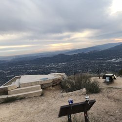
Scenic View in Altadena, California
Running Trails in Altadena, California
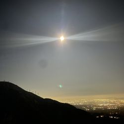
Places to Watch Sunset in Altadena, California
Off Leash Dog Hikes in Altadena, California
Forest in Altadena, California
Camping With Showers in Altadena, California
Open Fields Trails in Altadena, California
Bike Path in Altadena, California
Campgrounds in Altadena, California
Picnic Areas in Altadena, California
Trending Searches in Altadena, CA
Black Owned Nail Salons near Gabrielino Trail
Boat Rental near Gabrielino Trail
Cliff Jumping near Gabrielino Trail
Day Trips near Gabrielino Trail
Dog Friendly Trails near Gabrielino Trail
Fishing Spots near Gabrielino Trail
Jet Ski Rental near Gabrielino Trail
Kayak Rental near Gabrielino Trail
Lakes & Ponds near Gabrielino Trail
Off Road Trails near Gabrielino Trail
Outdoor Activities near Gabrielino Trail
Places To Walk Around near Gabrielino Trail
Public Pools near Gabrielino Trail
Public Shower near Gabrielino Trail
River Swimming near Gabrielino Trail
Rock Quarry near Gabrielino Trail
Scenic Night View near Gabrielino Trail
Scenic Overlook near Gabrielino Trail
Secluded Spots near Gabrielino Trail
Soccer Store near Gabrielino Trail
Splash Pad near Gabrielino Trail
Strawberry Picking near Gabrielino Trail
Sunrise View near Gabrielino Trail
Swimming Holes near Gabrielino Trail
Swimming Lakes near Gabrielino Trail
U Pick Farms near Gabrielino Trail
Watch Sunset near Gabrielino Trail
Browse Articles
Browse Nearby
BEST of Altadena, California Coffee near Gabrielino Trail
BEST of Altadena, California Things to Do near Gabrielino Trail
BEST of Altadena, California Restaurants near Gabrielino Trail
BEST of Altadena, California Walking Trails near Gabrielino Trail
BEST of Altadena, California Parks near Gabrielino Trail
BEST of Altadena, California Breakfast near Gabrielino Trail
BEST of Altadena, California Caves near Gabrielino Trail
BEST of Altadena, California Hot Springs near Gabrielino Trail
BEST of Altadena, California Campgrounds near Gabrielino Trail
Browse Brands
Related Searches in Altadena, CA
Best Fishing Locations and Guides in Altadena, California
Best Nature Trails for Hiking in Altadena, California
Best Places for Horseback Riding in Altadena, California
Best Waterfalls and Swimming Holes in Altadena, California
Check Out Off Road Trails in Altadena, California
Discover Dog Friendly Trails to Explore in Altadena, California
Discover Kid Friendly Hiking Trails in Altadena, California
Discover Scenic Hiking Trails in Altadena, California
Discover Scenic Mountain Bike Trails Near Altadena, California
Discover Scenic Waterfall Spots in Altadena, California
Discover Walking Parks in Altadena, California Near You
Discover a Hiking Trail in Altadena, California
Discover the Best Night Hike Trails in Altadena, California
Discover the Best Running Track in Altadena, California
Dog-Friendly Hikes With Dogs in Altadena, California
Enjoy Camping Adventures Around Altadena, California
Enjoy Exciting Mountain Biking Adventures in Altadena, California
Enjoy Kayaking Adventures in Altadena, California
Enjoy Tent Camping Spots Around Altadena, California
Enjoy a Beautiful Waterfall Hike in Altadena, California
Enjoy a Peaceful Nature Walk in Altadena, California
Enjoy the Best Walking Path in Altadena, California
Enjoy the Best Walking Trails in Altadena, California
Exciting Cliff Jumping Spots in Altadena, California
Explore Beautiful Parks and Green Spaces in Altadena, California
Explore Easy Hikes Perfect for All in Altadena, California
Explore Fun Activities to Do in Altadena, California
Explore Popular Campgrounds Near Altadena, California
Explore the Best Beach Spots in Altadena, California
Explore the Best Trail Options in Altadena, California
Family Friendly Hiking With Kids in Altadena, California
Find Beautiful Views in Altadena, California
Find the Best Parks for Picnics in Altadena, California
Find the Best Scenic View Locations in Altadena, California
Great Places to Walk in Altadena, California
Hike the Popular Waterfall Trail in Altadena, California
Hiking Trails With Waterfalls in Altadena, California
Off Leash Dog Hiking Trails in Altadena, California
Plan a Scenic Drive Route Near Altadena, California
Popular Outdoor Activities to Try in Altadena, California
Popular Picnic Spots to Visit in Altadena, California
Safe River Swimming Areas in Altadena, California
Safe and Fun Parks for Kids in Altadena, California
Top Climbing Spots and Gyms in Altadena, California
Top Paddleboarding Activities in Altadena, California
Top Running Trails to Explore in Altadena, California
Top Swimming Lakes to Enjoy in Altadena, California
Top Swimming Spots and Pools in Altadena, California
People who viewed Gabrielino Trail also viewed
El Prieto Trail
28 reviews
Tad Williams Trail
7 reviews
Hoegee's Loop Trail
20 reviews
Eagle Rock Canyon Trail
32 reviews
Pacific Palisades
Switzer Falls - USDA Forest Service
293 reviews
Eaton Canyon Natural Area
1330 reviews
Cherry Canyon Park
24 reviews
Mt Lowe
23 reviews
Descanso Trail
18 reviews
Bailey Canyon To Hastings Peak
54 reviews