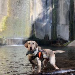
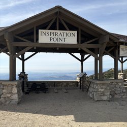
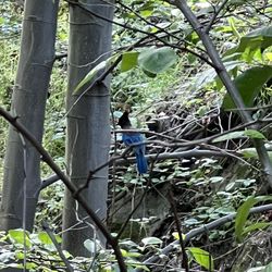
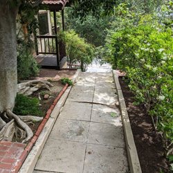
Descanso Trail Photos


You might also consider
More like Descanso Trail
Recommended Reviews - Descanso Trail
Start your review...

Reviews With Photos

This is a nice hidden gem for a short (about 3 miles) easily accessible hike. I entered off Descanso Dr. There's an entrance by the Descanso Garden parking lot. Plenty of free parking on the street. Once you enter it starts off with fairly steep inclines and then does plateau. Very wide and well maintained trail. Felt safe with plenty of room for social distancing if needed altho didn't see too many people. It made for a nice workout without the big crowd. With the inclines you do get quite a workout in.

For a neighborhood trail, this is a pretty nice, well-maintained trail. There are various entry points to the trail system, but not all allow for parking. Just park by Descano Gardens and start through Cherry Canyon. There are some good views, but there are also a ton of electrical transmission lines that'll muck up your photos. I doubt I go back out of my way to hike here again, but if it was outside my back door I'd be there all the time.

Tired of the hustle and bustle of Runyon? Welcome to Descanso Trail! Plenty of street parking outside the Descanso Gardens, this area offers plenty of options so that you can hike it over and over again, trying new permutations each time. Occasionally it's a steep incline, but the paths are well tended and smooth and the views are spectacular. It also isn't crowded, so for long stretches you have the entire vista to yourself. While there are some shorter options, most of the hikes last about a hour. Give yourself time to walk back to your car, which could take 15 minutes through beautiful and tranquil homes on wide streets dotted with oak trees.

The Descanso Trail is a great little cardio workout with some pretty scenery. The trail head is just west of the entrance to Descanso Gardens. There is a big wooden fence and three yellow posts. Walk down that path and then turn right at the end to begin your hike on the Descanso Trail. This is a steep climb off the bat to get your heart working and it switches back and forth to the top of the hill where it meets the fire road. If you just hike up and down on the trail it will be a round trip of about a mile. This trail is pretty difficult to come down on without poles, so if you don't have poles you can make a big loop around Descanso Gardens on the fire roads (3.73 miles). You will have elevation gains of 1,000 feet on this hike and it took me about an hour and ten minutes to make it back to my car. At the first intersection on the fire road turn left if you want to make the loop described above. Off to the left and up the hill you will see a rusted out water tower. Turn right when you see the next fire road past the bench.* You will be going downhill at this point. Eventually you'll end up on Forest Hill Trail which is a street. Walk down that until you see Los Padres Trail, make a right and Descanso Drive is a block up. Turn left and head west on Descanso Drive to where you parked your car. *If you head straight on the fire road you will end of on The Conservancy Trail which is a really nice little trail (.5 miles) It is definitely more of a hiking experience than walking on the fire road because it winds around through chapparal and oak woodland. It isn't very steep, so you don't need poles here. The mountain bikers like this trail. This intersects the fire road in the paragraph above and when you get to it turn left. http://www.lcftrails.org

I could give you an extensive review breaking down this hike and the route we took since there were a few forks along the way. It would be a giant waste of time. Instead....... please find Cydney M.'s review for the trail and follow that. That is what we did and it's so thorough, you don't even have to think about where to go on the the 3.6 mile loop. Some highlights: 1. The trail borders Descanso Gardens so you get an aerial view of the place. 2. I say aerial view because you are going to climb. Not terrible but enough to get your lungs frustrated with you. 3. One spot offers a good look at downtown and the ocean. Albeit, that's on a good, clear day. 4. The last part of the loop takes you through the streets of La Canada. I'll take one of those houses. Heck, I'll take a guest house. Definitely going to be back to try and improve on our 1 hour and 3 minute time. The best thing about using hiking apps is trying to complete the hike faster the next time.

6 years ago
Quiet, easy hiking trail for the whole family. Baby stroller access may be a little tricky the first 10-15 minutes. But after that it's smooth sailing. A very pleasant and peaceful walk. You may notice some freeway noise in some parts. HOW TO GET THERE: Set your GPS/Navigation to "Descanso Garden". You're going to park inside Descanso Garden anyways. Its free and its a 3 minute walk from the Trailhead. Do Not use the Yelp app's "Get Directions" on your smartphone. It'll take you to someone's house. I wish Yelp would correct this. PARKING: Don't tell anyone I told you this but I always park at Descanso Garden Parking Lot. It's free. I park my car right at the entrance to Descanso Garden so that I'm close to the entrance. There's always a gazillion empty parking spaces here. As soon as you park your car, walk back to the entrance (towards the main road, Descanso Drive) and then turn left onto the dirt sidewalk. You'll walk for a minute and find the 3 little yellow steel posts that other Yelpers described. That's your landmark for the entrance to the Trail. TRAILHEAD ACCESS: The trail begins about a 3 minute walk from the Descanso Garden parking lot. So when you exit the Descanso Garden parking lot, immediately turn left. Walk on the dirt sidewalk for less than a minute and on the left hand side you'll see 3 yellow steel posts (you know the kind that prevents people from driving over it). Walk through these 3 yellow posts and you'll find yourself walking on asphalt flanked by 8 feet tall brown colored fencing. You'll ask yourself "Am I at the right place?". Trust me, you are. Follow the signs and suddenly you'll find yourself at the trailhead. DIFFICULTY LEVEL: Easy. I went to Descanso Trail with my in-laws today. They're both in their mid-70's (very healthy) and they had no problems. The most difficult part of this trail comes about 5 minutes into the walk. You'll find yourself staring at an uphill climb consisting of several switchbacks. There's lots of loose rocks that someone can slip on. Especially small children and elderly. Climbing up is not bad. Even for my mid-70's in-laws they had no trouble. Did it without resting. Coming down these switch-backs is a little more challenging but definitely do-able for the healthy elderly. A walking/hiking stick will help. The rest of the hike is smooth sailing. Slight uphill and downhill walking here and there. Nothing challenging. The trail is made of compacted dirt, mainly about 5 feet to 10 feet wide. If you're a good hiker, if you've hiked Half Dome then this Descanso Trail hike will be a 'walk in the park'! BABY STROLLER: For about 99% of this trail, a stroller will have no problems whatsoever. However, within 5 minutes of starting this hike (read my "Difficulty Level" section above) you will find yourself at the bottom of an upward climb through some switchbacks. I think some healthy parent with a capable stroller probably could push the buggy uphill. But I believe for most parents, this will pose a challenge. You're better off holding the baby in your arms and having someone else carry the stroller uphill. Luckily, this uphill walk will take less than 5 minutes. After this, the rest of the trail is easy sailing for a stroller. Mainly compacted dirt. Keep in mind there are some gently upward and downward hills you need to navigate. CELLPHONE RECEPTION: I had 3 to 5 bars on my Verizon iPhone the whole time on the trail. No problems with reception at all. read more


Descanso trail is 3.1-mile loop trail in La Canada Flintridge, California near the Descanso Gardens. Generally, it is considered a moderately challenging route, it takes an average of 1 h 26 min to complete. However, it took me 2.5 hours (out-and-back) because of multiple rest stops to enjoy the awesome view. This is a popular trail for hiking, mountain biking, and running, but you can still enjoy some solitude during quieter times of day. Overall, it's one of a nicest hiking spot in LA county. read more

1 year ago
5 years ago
This is a nice hidden gem for a short (about 3 miles) easily accessible hike. I entered off Descanso Dr. There's an entrance by the Descanso Garden parking lot. Plenty of free parking on the street. Once you enter it starts off with fairly steep inclines and then does plateau. Very wide and well maintained trail. Felt safe with plenty of room for social distancing if needed altho didn't see too many people. It made for a nice workout without the big crowd. With the inclines you do get quite a workout in. read more


For a neighborhood trail, this is a pretty nice, well-maintained trail. There are various entry points to the trail system, but not all allow for parking. Just park by Descano Gardens and start through Cherry Canyon. There are some good views, but there are also a ton of electrical transmission lines that'll muck up your photos. I doubt I go back out of my way to hike here again, but if it was outside my back door I'd be there all the time. read more


3 years ago
Tired of the hustle and bustle of Runyon? Welcome to Descanso Trail! Plenty of street parking outside the Descanso Gardens, this area offers plenty of options so that you can hike it over and over again, trying new permutations each time. Occasionally it's a steep incline, but the paths are well tended and smooth and the views are spectacular. It also isn't crowded, so for long stretches you have the entire vista to yourself. While there are some shorter options, most of the hikes last about a hour. Give yourself time to walk back to your car, which could take 15 minutes through beautiful and tranquil homes on wide streets dotted with oak trees. read more


The Descanso Trail is a great little cardio workout with some pretty scenery. The trail head is just west of the entrance to Descanso Gardens. There is a big wooden fence and three yellow posts. Walk down that path and then turn right at the end to begin your hike on the Descanso Trail. This is a steep climb off the bat to get your heart working and it switches back and forth to the top of the hill where it meets the fire road. If you just hike up and down on the trail it will be a round trip of about a mile. This trail is pretty difficult to come down on without poles, so if you don't have poles you can make a big loop around Descanso Gardens on the fire roads (3.73 miles). You will have elevation gains of 1,000 feet on this hike and it took me about an hour and ten minutes to make it back to my car. At the first intersection on the fire road turn left if you want to make the loop described above. Off to the left and up the hill you will see a rusted out water tower. Turn right when you see the next fire road past the bench.* You will be going downhill at this point. Eventually you'll end up on Forest Hill Trail which is a street. Walk down that until you see Los Padres Trail, make a right and Descanso Drive is a block up. Turn left and head west on Descanso Drive to where you parked your car. *If you head straight on the fire road you will end of on The Conservancy Trail which is a really nice little trail (.5 miles) It is definitely more of a hiking experience than walking on the fire road because it winds around through chapparal and oak woodland. It isn't very steep, so you don't need poles here. The mountain bikers like this trail. This intersects the fire road in the paragraph above and when you get to it turn left. http://www.lcftrails.org read more


I could give you an extensive review breaking down this hike and the route we took since there were a few forks along the way. It would be a giant waste of time. Instead....... please find Cydney M.'s review for the trail and follow that. That is what we did and it's so thorough, you don't even have to think about where to go on the the 3.6 mile loop. Some highlights: 1. The trail borders Descanso Gardens so you get an aerial view of the place. 2. I say aerial view because you are going to climb. Not terrible but enough to get your lungs frustrated with you. 3. One spot offers a good look at downtown and the ocean. Albeit, that's on a good, clear day. 4. The last part of the loop takes you through the streets of La Canada. I'll take one of those houses. Heck, I'll take a guest house. Definitely going to be back to try and improve on our 1 hour and 3 minute time. The best thing about using hiking apps is trying to complete the hike faster the next time. read more


11 years ago
This was a nice hike around Descanso Gardens. I went on New Year's Day so the Gardens were pretty dormant, but it was nice and hilly with some good views and a variety of paths to choose from. Please be aware the entrance is NOT across the street from Descanso Gardens, but on the same side towards the west. I saw a sign with the word "Descanso" and "Trail" and ended up crossing the 210 into the town there. I hear Magpie's is good for brunch but they were closed. ;) It did add an extra mile to my hike, so I guess it was good for my cardio :) This would be a great hike if you have dogs. You'll also get to pass close to the Glendale Police shooting range where there's bound to be some popping. I will definitely be going back to try some more of the other trails. read more


12 years ago
5 years ago
6 years ago
13 years ago
12 years ago
More info about Descanso Trail
Ask the Community - Descanso Trail
Review Highlights - Descanso Trail
You might also consider


Why does Yelp recommend reviews?
3 reviews that are not currently recommended
The reviews below are not factored into the business's overall star rating.
3 years ago
2 years ago
9 years ago
Descanso Trail - hiking - Updated July 2026
Best of La Cañada Flintridge
People found Descanso Trail by searching for…
Hiking Trails in La Cañada Flintridge, California
Parks in La Cañada Flintridge, California
Things to Do in La Cañada Flintridge, California
Walking Trails in La Cañada Flintridge, California
Easy Hikes in La Cañada Flintridge, California
Lookout Points in La Cañada Flintridge, California
Running Trails in La Cañada Flintridge, California
Hiking Trails Kid Friendly in La Cañada Flintridge, California
Empty Parking Lot in La Cañada Flintridge, California
Free Parking in La Cañada Flintridge, California
Bike Paths in La Cañada Flintridge, California
Beautiful Views in La Cañada Flintridge, California
Shaded Hike in La Cañada Flintridge, California
Places to Watch Sunset in La Cañada Flintridge, California
Scenic View in La Cañada Flintridge, California
Secret Spots in La Cañada Flintridge, California
Stroller Friendly Hikes in La Cañada Flintridge, California
Views in La Cañada Flintridge, California
Waterfall Hike in La Cañada Flintridge, California
Trails in La Cañada Flintridge, California
Parks for Kids in La Cañada Flintridge, California
Lakes & Ponds in La Cañada Flintridge, California
Trending Searches in La Cañada Flintridge, CA
Black Owned Nail Salons in La Cañada Flintridge, CA
Boat Rental in La Cañada Flintridge, CA
Cliff Jumping in La Cañada Flintridge, CA
Day Trips in La Cañada Flintridge, CA
Fishing Spots in La Cañada Flintridge, CA
Jet Ski Rental in La Cañada Flintridge, CA
Kayak Rental in La Cañada Flintridge, CA
Lakes in La Cañada Flintridge, CA
Off Road Trails in La Cañada Flintridge, CA
Outdoor Activities in La Cañada Flintridge, CA
Places To Walk Around in La Cañada Flintridge, CA
Pool Day Pass in La Cañada Flintridge, CA
Public Pools in La Cañada Flintridge, CA
Public Shower in La Cañada Flintridge, CA
River Swimming in La Cañada Flintridge, CA
Rock Quarry in La Cañada Flintridge, CA
Running Trails in La Cañada Flintridge, CA
Scenic Night View in La Cañada Flintridge, CA
Scenic Overlook in La Cañada Flintridge, CA
Secluded Spots in La Cañada Flintridge, CA
Soccer Store in La Cañada Flintridge, CA
Splash Pad in La Cañada Flintridge, CA
Strawberry Picking in La Cañada Flintridge, CA
Sunrise View in La Cañada Flintridge, CA
Swimming Holes in La Cañada Flintridge, CA
Swimming Lakes in La Cañada Flintridge, CA
Watch Sunset in La Cañada Flintridge, CA
Browse Articles
Browse Nearby
BEST of La Cañada Flintridge, California Coffee near Descanso Trail
BEST of La Cañada Flintridge, California Things to Do near Descanso Trail
BEST of La Cañada Flintridge, California Restaurants near Descanso Trail
BEST of La Cañada Flintridge, California Walking Trails near Descanso Trail
BEST of La Cañada Flintridge, California Parks near Descanso Trail
BEST of La Cañada Flintridge, California Breakfast near Descanso Trail
BEST of La Cañada Flintridge, California Campgrounds near Descanso Trail
BEST of La Cañada Flintridge, California Sledding near Descanso Trail
BEST of La Cañada Flintridge, California Day Trips near Descanso Trail
Browse Brands
Related Searches in La Cañada Flintridge, CA
Best Dog Hiking Trails Around La Cañada Flintridge, California
Best Fishing Locations and Guides in La Cañada Flintridge, California
Best Nature Trails for Hiking in La Cañada Flintridge, California
Best Places for Horseback Riding in La Cañada Flintridge, California
Check Out Off Road Trails in La Cañada Flintridge, California
Discover Dog Friendly Trails to Explore in La Cañada Flintridge, California
Discover Easy Hiking Trails Near La Cañada Flintridge, California
Discover Kid Friendly Hiking Trails in La Cañada Flintridge, California
Discover Popular Bike Trails in La Cañada Flintridge, California
Discover Scenic Mountain Bike Trails Near La Cañada Flintridge, California
Discover Walking Parks in La Cañada Flintridge, California Near You
Discover a Hiking Trail in La Cañada Flintridge, California
Discover the Best Night Hike Trails in La Cañada Flintridge, California
Dog-Friendly Hikes With Dogs in La Cañada Flintridge, California
Enjoy Camping Adventures Around La Cañada Flintridge, California
Enjoy Kayaking Adventures in La Cañada Flintridge, California
Enjoy Off Leash Dog Hikes in La Cañada Flintridge, California
Enjoy Scenic Places to Walk in La Cañada Flintridge, California
Enjoy a Beautiful Waterfall Hike in La Cañada Flintridge, California
Enjoy the Best Walking Path in La Cañada Flintridge, California
Enjoy the Best Walking Trails in La Cañada Flintridge, California
Explore Beautiful Parks and Green Spaces in La Cañada Flintridge, California
Explore Easy Hikes Perfect for All in La Cañada Flintridge, California
Explore Fun Activities to Do in La Cañada Flintridge, California
Explore Popular Campgrounds Near La Cañada Flintridge, California
Explore Popular Dog Walking Trails in La Cañada Flintridge, California
Explore Top Dog Parks in La Cañada Flintridge, California Near You
Explore the Best Beach Spots in La Cañada Flintridge, California
Family Friendly Hiking With Kids in La Cañada Flintridge, California
Find Beautiful Views in La Cañada Flintridge, California
Find Parks and Recreation Activities in La Cañada Flintridge, California
Find Top Dog Friendly Parks to Visit in La Cañada Flintridge, California
Find Top-Rated Waterfalls in La Cañada Flintridge, California Now
Find the Best Parks for Picnics in La Cañada Flintridge, California
Hiking Trails With Waterfalls in La Cañada Flintridge, California
Off Leash Dog Hiking Trails in La Cañada Flintridge, California
Popular Outdoor Activities to Try in La Cañada Flintridge, California
Popular Picnic Spots to Visit in La Cañada Flintridge, California
Popular Waterfall Hiking Trails in La Cañada Flintridge, California
Safe River Swimming Areas in La Cañada Flintridge, California
Safe and Fun Parks for Kids in La Cañada Flintridge, California
Top Hiking Trails to Explore in La Cañada Flintridge, California
Top Playgrounds for Kids to Enjoy in La Cañada Flintridge, California
Top Running Trails to Explore in La Cañada Flintridge, California
Top Swimming Lakes to Enjoy in La Cañada Flintridge, California
Top Swimming Spots and Pools in La Cañada Flintridge, California
Top-Rated Camping Sites in La Cañada Flintridge, California
Walk Dog Friendly Hiking Trails in La Cañada Flintridge, California
Walk the Best Paved Walking Trails in La Cañada Flintridge, California