Dawn Mine Hike Photos


You might also consider
More like Dawn Mine Hike
Recommended Reviews - Dawn Mine Hike
Start your review...

Reviews With Photos

This is an excellent hike near LA. When you go make sure you go early. There is limited parking. Off season may be easier to find parking. I took this hike with my daughter and she loved it as well. There is lots of shade although on our way back there was little shade. Just bring plenty of water. There are a few steep areas so be careful. Some of these steep areas have significant social trails made. This also has caused erosion so it is hard to tell which one is the real trail. They all go back to the main trail but just watch out for signs to help you stay on the trail. Leaving the trail significantly hurts the trail. Especially with bikes.
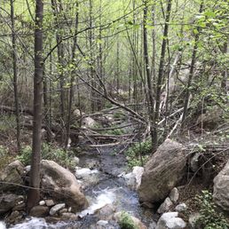
First time on this trail/hike and absolutely loved it. The scenery was amazing. Absolutely love the stream that runs along the trail. Don't know if it flows all year or just from all the rain we've been getting. Perfect for a solo hike or with a group as I did. Nice to have another trail that's not far from LA as all the one in the city is to congested with people. IE, Runyon canyon, Griffith. Highly recommended this place and will be returning.

I visited Dawn Mine trail this past Sunday, March 26, 2017. I tried following the directions given on a few different Yelp reviews, but unfortunately, I was still pretty confused. Apparently, there are a few different ways to reach the mines. This is the way we went. My friends and I parked along Chaney Road. We headed past the white gate onto the fire road. We followed the paved road for over than an hour. It's all uphill with zero shade so it was pretty tough. We came across a handful of bikers who were on their way to Inspiration Point. I started getting scared that we were on the wrong path. We finally came across a group of hikers who told us that we were going the right way. Thank goodness for friendly strangers! You will hit a fork in the road where you can either go left or stick right; just stick right. Keep walking for another 30 minutes and you'll pass a brown structure that has some benches on your left (I think it was a restroom but I didn't check). Stay on the paved path until it becomes a dirt road. You'll walk maybe 5 minutes until you see a tree on your left with the sign "DAWN MINE," leading to a path that goes downhill. Walk all the way to the bottom (it takes about 40 minutes) where you'll see a small, pretty waterfall. After enjoying the sight of the waterfall, cross the stream and find the abandoned goldmine hidden between some large boulders. Make sure you have headlamps! The cave is filled with water (up to your ankles) and you'll want both hands so you can navigate without getting too wet. There's a small waterfall within this cave too, but you'll have to walk past this hole that's apparently 50 feet deep, so tread carefully ! We wanted to explore past the waterfall but that path was knee-deep in water, so we passed. We returned the way we came in and we were so exhausted! It's a gorgeous and interesting trail but it was definitely a challenge. I highly recommend checking out Dawn Mine!

If you're looking for a climbing, scaling, crawling over and under, sometimes jungle like experience filled with plenty of mosquitos, spiders, butterflies, dragonflies, snakes, bumps, scrapes and bruising this is the hike for you! I can admit, for a hike short in mileage it sure made me it's b*tch! My boyfriend and I had decided to hike to the Dawn Mine vs hiking Mt Wilson but boy did we really have to work for it. Getting there was a trek! We took several wrong turns so it took a lot longer than it did heading back from the mine. We started the hike at 11A and were finished by 4P, including wrong turns, back tracking and spending time in the mine. We had printed out extremely detailed instructions to which I yelled "crazy mother f*cker" at least a dozen times at. This is definitely not the hike for the faint at heart. Be prepared to take some wrong turns. I think our instructions were too detailed. Once finally reaching the mine, I really had no intention of going in but we met a guy who was up there and we both decided we'd go in. He had a good flashlight, headlamp, and we had our flashlights on our phones. Going into the mine and exploring so many different tunnels was probably the coolest part. I was scared silly of course but what a cool experience! Someone had set up a system for the water the drain out a bit so it surely wasn't calf deep when we went in. Most areas were around 4 inches deep, except for the 50 foot deep area which you absolutely do not want to f with. I'd sum up directions in simple form. Park at the trail head (Sunset Ridge) above the Millard parking lot (where an Adventure Pass is not needed and some shade is provided by trees). Proceed up the fire road, passing the sign in book. Don't turn either way onto any trail, continue past this and look towards your left for the Sunset Ridge Trail 12W18. Take this trail until you come to a fork in the road and hang a left down below the cabin. Once on this trail you'll hit another point at the creek where you can turn left or right, hang a right and this is where I say basically stick to the right hand side the entire time always following what appears to be a trail. There are times you'll seem confused or not really see a clear path, take a few steps always in search for something that appears to be it and more than likely that's it. I guess my main stress point here is Keep Right on the way in and on the way out keep Left and this helps you follow the trail best. Look at for cairns and ribbons tied to things to help you along the way. Of course there will be tons of weaving left to right and crossing over the stream but keep Right or you will end up going to wrong way (which we did at least 2 or 3x). You'll eventually start to see black arrows painted on boulders, continue to follow these up and you'll get there! Descending and coming back to where you've parked should take roughly 90 or so minutes give or take how swiftly you're moving. I'd say its a hike that is more than moderate but I can see how if you get it right the first time, it can be somewhat moderate. I have a good feeling we went through a lot more than we needed to have to get to the mine. My advice is start early in the day, so in case you do take a few wrong turns you still have plenty of time to get back on track and don't give up once getting to the mine. I'd also say don't get to the mine and take a picture of the entrance like I was all set to do. Go in! It's scary looking but how many times have you explored an old gold mine. Bring flashlights and headlamps it's pitch black inside. Pack snacks and water. My boyfriend drank his entire 3L camelbak. I had 1.5 liters of mine. We had one or two snacks in total. Sunscreen and a hat/visor aren't a bad idea either, and pants are probably a REALLY good idea! Happy Trails!

Where there's a will, there's a way. This is definitely a hike for adventure seekers! This 5 mile round trip hike is not too difficult, but definitely not for beginners...especially if you choose to take the exact same path to and from. There's so much foliage, logs, creeks, and rocks or boulders that you have to hike through, under, over, around, etc. You won't find trail runners on this hike. Since there is no clear trail, you should always look out for signs that other hikers have left to show you you're on the right track. There may be many moments when you'll wonder if you're even going in the right direction at all, but just look for spray painted arrows, stacked rocks, ribbons, and (I hate to say it) even trash. There are also many moments where you'll feel like there's no way to go forward, but you'll just need to tap into that flexible, acrobatic, bouldering mindset and you'll be okay. If you don't pay attention, you may get lost for a few minutes, but it's not impossible to find your way back to the right path. I try to look backward as I walk forward so that I can get a visual of the path back. The mine itself...I can't really tell you because after staring into the small tunnel, my claustrophobia prevented me from going all the way in. It was, however, a great feeling to know that we actually made it! I hiked with a friend, but I've seen multiple hikers doing this one solo. A few tips: - Bring lots of water and food or snacks to munch along the way. Also just in case you get lost on a trail for longer than expected. - Bring a flashlight in case you find the mine and wish to go in. - Hike in long pants and/or be prepared with bug spray. I almost doused myself in bug spray because of the amount of bugs. Also, there are lots of rocks, logs, and other things that may cut you along the trail. - Keep your adventure pass on your car so that you won't get a ticket. Would I do this hike again? Definitely! I feel like I have a better gage of the trail, so it should be slightly easier with less moments of feeling confused. Hopefully the foliage won't grow too much by then.

First time on this hike and this one is a doozy. I'll telll you guys later in my review. Adventure pass: Adventure pass is required but others that haved hiked at this place risk it and don't have one or don't know where to get one.. If you don't want to risk a hefty fine, go ge an adventure pass. Parking: Parking is accessable along Chaney Trail Rd. Early birds get to park near the trail head. Make sure you have your parking pass. Hiking Mileage: 2 1/2 miles out...2 1/2 miles back. Visual markers to follow to mine: Look for pink ribbons, small rock formations, and black arrows graffiti on big boulders. Way to get there.... Look at pictures! Hiking observation: Intermediate 1) Adventure hike seekers should love this hike. You can easily get lost. For the most part there are no signs. 2) Steep narrow hiking trail (single line) and at times the hike goes off trail. 3) Isn't really a well maintained hike trail. Lots of overgrown foliage 4) A lot of insects... bring bug repellent. I think i got bitten couple of times on this hike 5) Expect to get dirty! A lot of sliding down rocks, brushing up against branches, and stream crossings. Streams were very shallow today. 6) Watch out for bushes and trees stabbing you with their branches. Bring long pants. 7) A lot of over and unders with tree logs. Be very cautious. Its physically and mentally draining when you bump your head into tree logs. I ducked one log then the next one clobbers me when I stand up! Might have a concussion. (DOOZY) 8) Stay hydrated and bring some snacks to sustain you.... My two liter bottles weren't enough. Both of my legs started cramping on the way back and was basically dragging myself to finish. 8) Last part to the mine is primarily boulder hopping and sections off trail hiking. trail. Make sure you have hiking shoes. As for me I was doing this with running shoes. No bueno. Felt at times I would sprained my ankle, but those were minor tweaks. If you get lost, try to find pink ribbons, black arrows, and small rock formations. My friend and I put about three or four on those on the way back for reaching hiking destination easily. Came home fatigued and battered up, but will definitely come back for more fun.

I love how adventurous this hike was. I would definitely suggest to wear good, slip resistant, well gripped hiking shoes. There is definitely some rock climbing involved. Most of the trail is covered with rocks; so be very careful. Overall, the views of this hike were so amazing; very quiet and serene. It was a 5.0 moderate mile hike. And you will encounter a few friendly squirrels along the way.

For information about the DAWN MINE CLOSURE CONTACT MIKE MCINTYRE WHO IS RESPONSIBLE FOR THIS PROJECT AND ITS CLOSURE. Dawn Mine Entry Access Control Project #43653 Commenting on This Project Comments, including anonymous comments, will be accepted at any time. However, comments posted after the close of a designated comment period may not be able to be given full consideration. Anonymous comments and comments submitted after the close of the final designated comment period will not provide the commenter standing for administrative review. The Forest Service values public participation. Communications from the public regarding this project, including commenter's names and contact information, will become part of the public record. Comments, or in some cases other expressions of interest, along with respondent's contact information, submitted during the comment period may be necessary to establish a respondent's eligibility to participate in an administrative review for this proposed action. Interested members of the public should review the proposal's information to determine the applicable administrative review process and the eligibility requirements for that process. The date of the legal notice of opportunity to comment on this proposed action is the exclusive means for calculating the comment period. For proposals to be documented with an Environmental Assessment, the legal notice announcing the comment period appears in the Newspaper of Record . For Draft Environmental Impact Statements, the Notice of Availability announcing the comment period appears in the Federal Register. Submitting Comments If you wish to submit a comment, please send it to: Mike McIntyre Los Angeles River 12371 N. Little Tujunga Canyon Rd , San Fernando, CA, 91342 mmcintyre@fs.fed.us 818-899-1900

Bring an adventure pass. Parking lot accommodates about 10 cars so come early for space. I took the last spot on a Friday afternoon. The loop trail stretches a little over 5 miles with a gain of 1800 ft in elevation. If you choose to only go to the mine and back I would rate that part as mildly moderate, but the whole loop is considered hard. I decided to do it counterclockwise. This portion is highlighted with switchbacks and all the elevation gain for about 3 miles. The path is mostly easy, but towards the end of the ascension it becomes pretty much just carved rock and the trail is very narrow. Shoes with good traction and a hiking stick would make this part much easier because there's loose gravel and you'll have about 10 inches of space hop along this uneven jagged path. Having done this way up accompanied by the sun on a 90 degree day made me finish almost all my 3 liters of water. Once you reach the bed of the creek in the canyon there's a lovely rest stop for you to cool off as temperatures and elevation drops dramatically. The mine gives itself away easily! If you choose to explore it bring sandals. The water looks gross but it's mostly clean, you just don't want to accidentally step on anything sharp. There's a guest book too, but bring your own pen to sign in. The remainder of the trip back was easy and fun to traverse. Many hikers have drawn out arrows and constructed trail markers making the way evident, but since it is in a canyon there's only one way to go back. It shouldn't be too hard to figure out especially since the newest graffitis with derogatory things said about Trump will show you the way. Btw guys we shouldn't be defacing the national forest for our own political statements. It does nothing except reminds us of the annoying current state of our country and I came here to forget about that. Please keep your manners about you.

DO THIS HIKE. It is tough, so pack water and a snack, but incredibly gorgeous and so rewarding. This hike is not for the faint of heart - it is a legit hike, so get ready for that heart rate to go up (and to tone that booty). If you park at the Millard Camp trail head make sure you take the Sunset Ridge Trailhead to get to the Dawn Mine - it's incredible (especially this time of the year... SO GREEN). Definitely one of my favorite hikes I've done in LA. Will for sure be going back. It is a long hike and most of it is in the sun so make sure you have the map (at the trail head and posted here) and bring water and sun screen. Gorgeous views and loads of history.

Dawn Mine is an easy, short, but exciting hike. There are lots of shade, rock formations, and a waterfall at the end!--oh and the mine!! Also, there's a stream that runs along the hike that you constantly have to cross. Very fun! It's the perfect summer hike. Bring a sweater during the winter months because it gets chilly! I would definitely go more often it wasn't so far inland! There needs to be more hikes like this on the westside!

I love this hike. 1. It is not a glorified walk. 2. It's a great workout. 3. Totally surrounded by nature because you're in the canyon. 4. Lots of rock scrambling, boulder-hopping, stream-crossing. That said, it's not really for beginners or the unprepared. A map is helpful, but you might lose the trail a few times because it's not clearly marked. Don't panic. You're basically following the water up, then back. There are some arrows and cairns and tape, but you have to make a lot of judgement calls. My rule for this hike is: if it seems too precarious, you've probably lost the trail. You don't have to scale any rock faces or climb up tree roots to get there... just backtrack, and find the more reasonable path. The mine is cool, but if you want to go inside, bring a headlamp or flashlight... water shoes or just take your socks off. I don't recommend using a phone flashlight because it helps to have both hands free to brace yourself again the rock walls-- the logs and boards you can step on are not stable, they just help your feet stay a bit drier. Display your adventure pass when you park. Bring lots of water. Wear long pants. Have fun!

This hike is about 7 miles round trip with about 2000' elevation gain/loss. The hike is not that difficult, but can be a challenging hike in terms of obstacles. If climbing over rocks and boulders and hiking through high brush is not your thing, then I would skip this hike. For me, it was an interesting hike. Most of the trail is single file and there are lots of rocks and boulders to climb over and around. There are also a few streams that you must cross. The elevation really does not seem tough. Parts of the trail are both shaded and unshaded. Once at your destination, you will see a tiny opening in the rock which designates the opening to the old mine. It's small with a lot of humidity and dampness. There is also some water to trek through, depending on how far you decide to go. It's interesting to experience once. parking - small lot. Adventure pass required

This hike had a lot to offer. Pretty green mostly covered trails a lot of crossing water when it had rained before. About a 6-7mile hike round trip depending on your starting point we started around Altadena area by fair oaks street. Bring- a lot of water depending on how you handle hiking Adventure pass is needed to park I don't use them but some walking / trek sticks could be useful in some parts. I'm a large guy it took a lot out of me to get there it's a moderate to hard hike for me. With more exercise and a few more hikes under my belt to get back into shape I would hike it again. A lot of connecting places to hike through to as well. Echo mountain connection - inspiration point . read more


One of my favorite hikes in LA. I would rate this as Moderate given the elevation change and rocky paths but it's possible for all ages and skill levels. You get to hike through many different zones including goat paths on the side of the mountain, paved roads at the beginning, and multiple creek crossings and some minor boulder climbing. Parking is at the top of where you turn left to go down toward Millard Falls and there are only 6 spaces available so that area fills up quickly. We arrived @ 7:30AM and didn't have any issues parking and didn't encounter anyone until our hike back out. It's easy to follow the path as it's marked well. The first landmark you'll see is a formerly used cabin as you descend down into the canyon and as you follow the canyon to the end you will see many old mining equipment and plumbing strewn near the creek you are walking parallel to. You have to cross the creek a few times but it's only a few inches deep and there are rocks already placed for crossing. There are portions with pools deep enough to dunk in and even a section with 3 small pools with water slides into each pool. Something worth checking out when the weather is warmer. The mine at the end is underwhelming because it's blocked off with steel bars and is very low to the ground and is flooded with water. I would say the walk to the mine is the best part not the destination. Overall a great hike with beautiful scenery and hiking with the sound of running water the whole time is a real treat. read more


Looking for the dawn mine was actually pretty confusing. The first sign with the map doesn't even point out where it is. I ended up staying on the concrete road, Mt. Lowe road instead of taking the side trail down towards Millard Trail (the easier path along the creek/water), and so we made a giant loop instead. I was quite disappointed when we realized that we went the wrong way to the mine until we stumbled upon a couple we saw earlier that took the side trail and asked if there was a way to the mine. So regardless of which route you take it does end up in a loop. However, be aware if you take the concrete road up towards Mt. Lowe to the mine you might miss the sign to the dawn mine like we did. Plus, it's a lot more strenuous of a hike because there is a lot more of a incline. We ended up hiking an extra mile up past horseshoe curve until we gave up on finding it since google maps was not helpful at all and reception was hard for any googling of hiking websites. It wasn't until we were walking back down the mountain that we saw some wooden like stairs on the side and said maybe that might be our route. When we got closer there was a tiny white sign on a tree that said Dawn Mine 1 mile. The entrance to the Mine also had one of those signs that tells you the history of this historic trial. It is past cape of good hope but before horseshoe curve. The sign stated how there was a dawn station in the past. What's sad was, we even stopped at each sign to read what's it about and missed the entrance down. Walking down this 1 mile route was very narrow and steep. So for beginning hikers this might not be the best route for you to go down. Even though it was only a mile down, it was very rocky and I felt like people could easily slip. To be honest, this dawn mine was very anticlimactic. I think partly because we went the wrong way and got lost but mainly because when we finally found it, the entrance to the cave was closed off with steel bars. There was really nothing to see there unfortunately. The hike back to sunset ridge (parking) was nice. The path we should have taken had a lot of weaving back and forth between the creek. To our surprise there was still water following in October! However, as nice as the hike was going back, I am glad I didn't give up and try to hike this again in search of the mine. It was a good exercise I guess, but if you're going just to see the mine, you will truly be disappointed. read more


 - Hiking Near Me - Altadena, California")
This is an excellent hike near LA. When you go make sure you go early. There is limited parking. Off season may be easier to find parking. I took this hike with my daughter and she loved it as well. There is lots of shade although on our way back there was little shade. Just bring plenty of water. There are a few steep areas so be careful. Some of these steep areas have significant social trails made. This also has caused erosion so it is hard to tell which one is the real trail. They all go back to the main trail but just watch out for signs to help you stay on the trail. Leaving the trail significantly hurts the trail. Especially with bikes. read more


9 years ago
First time on this trail/hike and absolutely loved it. The scenery was amazing. Absolutely love the stream that runs along the trail. Don't know if it flows all year or just from all the rain we've been getting. Perfect for a solo hike or with a group as I did. Nice to have another trail that's not far from LA as all the one in the city is to congested with people. IE, Runyon canyon, Griffith. Highly recommended this place and will be returning. read more


I visited Dawn Mine trail this past Sunday, March 26, 2017. I tried following the directions given on a few different Yelp reviews, but unfortunately, I was still pretty confused. Apparently, there are a few different ways to reach the mines. This is the way we went. My friends and I parked along Chaney Road. We headed past the white gate onto the fire road. We followed the paved road for over than an hour. It's all uphill with zero shade so it was pretty tough. We came across a handful of bikers who were on their way to Inspiration Point. I started getting scared that we were on the wrong path. We finally came across a group of hikers who told us that we were going the right way. Thank goodness for friendly strangers! You will hit a fork in the road where you can either go left or stick right; just stick right. Keep walking for another 30 minutes and you'll pass a brown structure that has some benches on your left (I think it was a restroom but I didn't check). Stay on the paved path until it becomes a dirt road. You'll walk maybe 5 minutes until you see a tree on your left with the sign "DAWN MINE," leading to a path that goes downhill. Walk all the way to the bottom (it takes about 40 minutes) where you'll see a small, pretty waterfall. After enjoying the sight of the waterfall, cross the stream and find the abandoned goldmine hidden between some large boulders. Make sure you have headlamps! The cave is filled with water (up to your ankles) and you'll want both hands so you can navigate without getting too wet. There's a small waterfall within this cave too, but you'll have to walk past this hole that's apparently 50 feet deep, so tread carefully ! We wanted to explore past the waterfall but that path was knee-deep in water, so we passed. We returned the way we came in and we were so exhausted! It's a gorgeous and interesting trail but it was definitely a challenge. I highly recommend checking out Dawn Mine! read more


11 years ago
If you're looking for a climbing, scaling, crawling over and under, sometimes jungle like experience filled with plenty of mosquitos, spiders, butterflies, dragonflies, snakes, bumps, scrapes and bruising this is the hike for you! I can admit, for a hike short in mileage it sure made me it's b*tch! My boyfriend and I had decided to hike to the Dawn Mine vs hiking Mt Wilson but boy did we really have to work for it. Getting there was a trek! We took several wrong turns so it took a lot longer than it did heading back from the mine. We started the hike at 11A and were finished by 4P, including wrong turns, back tracking and spending time in the mine. We had printed out extremely detailed instructions to which I yelled "crazy mother f*cker" at least a dozen times at. This is definitely not the hike for the faint at heart. Be prepared to take some wrong turns. I think our instructions were too detailed. Once finally reaching the mine, I really had no intention of going in but we met a guy who was up there and we both decided we'd go in. He had a good flashlight, headlamp, and we had our flashlights on our phones. Going into the mine and exploring so many different tunnels was probably the coolest part. I was scared silly of course but what a cool experience! Someone had set up a system for the water the drain out a bit so it surely wasn't calf deep when we went in. Most areas were around 4 inches deep, except for the 50 foot deep area which you absolutely do not want to f with. I'd sum up directions in simple form. Park at the trail head (Sunset Ridge) above the Millard parking lot (where an Adventure Pass is not needed and some shade is provided by trees). Proceed up the fire road, passing the sign in book. Don't turn either way onto any trail, continue past this and look towards your left for the Sunset Ridge Trail 12W18. Take this trail until you come to a fork in the road and hang a left down below the cabin. Once on this trail you'll hit another point at the creek where you can turn left or right, hang a right and this is where I say basically stick to the right hand side the entire time always following what appears to be a trail. There are times you'll seem confused or not really see a clear path, take a few steps always in search for something that appears to be it and more than likely that's it. I guess my main stress point here is Keep Right on the way in and on the way out keep Left and this helps you follow the trail best. Look at for cairns and ribbons tied to things to help you along the way. Of course there will be tons of weaving left to right and crossing over the stream but keep Right or you will end up going to wrong way (which we did at least 2 or 3x). You'll eventually start to see black arrows painted on boulders, continue to follow these up and you'll get there! Descending and coming back to where you've parked should take roughly 90 or so minutes give or take how swiftly you're moving. I'd say its a hike that is more than moderate but I can see how if you get it right the first time, it can be somewhat moderate. I have a good feeling we went through a lot more than we needed to have to get to the mine. My advice is start early in the day, so in case you do take a few wrong turns you still have plenty of time to get back on track and don't give up once getting to the mine. I'd also say don't get to the mine and take a picture of the entrance like I was all set to do. Go in! It's scary looking but how many times have you explored an old gold mine. Bring flashlights and headlamps it's pitch black inside. Pack snacks and water. My boyfriend drank his entire 3L camelbak. I had 1.5 liters of mine. We had one or two snacks in total. Sunscreen and a hat/visor aren't a bad idea either, and pants are probably a REALLY good idea! Happy Trails! read more


11 years ago
Where there's a will, there's a way. This is definitely a hike for adventure seekers! This 5 mile round trip hike is not too difficult, but definitely not for beginners...especially if you choose to take the exact same path to and from. There's so much foliage, logs, creeks, and rocks or boulders that you have to hike through, under, over, around, etc. You won't find trail runners on this hike. Since there is no clear trail, you should always look out for signs that other hikers have left to show you you're on the right track. There may be many moments when you'll wonder if you're even going in the right direction at all, but just look for spray painted arrows, stacked rocks, ribbons, and (I hate to say it) even trash. There are also many moments where you'll feel like there's no way to go forward, but you'll just need to tap into that flexible, acrobatic, bouldering mindset and you'll be okay. If you don't pay attention, you may get lost for a few minutes, but it's not impossible to find your way back to the right path. I try to look backward as I walk forward so that I can get a visual of the path back. The mine itself...I can't really tell you because after staring into the small tunnel, my claustrophobia prevented me from going all the way in. It was, however, a great feeling to know that we actually made it! I hiked with a friend, but I've seen multiple hikers doing this one solo. A few tips: - Bring lots of water and food or snacks to munch along the way. Also just in case you get lost on a trail for longer than expected. - Bring a flashlight in case you find the mine and wish to go in. - Hike in long pants and/or be prepared with bug spray. I almost doused myself in bug spray because of the amount of bugs. Also, there are lots of rocks, logs, and other things that may cut you along the trail. - Keep your adventure pass on your car so that you won't get a ticket. Would I do this hike again? Definitely! I feel like I have a better gage of the trail, so it should be slightly easier with less moments of feeling confused. Hopefully the foliage won't grow too much by then. read more


First time on this hike and this one is a doozy. I'll telll you guys later in my review. Adventure pass: Adventure pass is required but others that haved hiked at this place risk it and don't have one or don't know where to get one.. If you don't want to risk a hefty fine, go ge an adventure pass. Parking: Parking is accessable along Chaney Trail Rd. Early birds get to park near the trail head. Make sure you have your parking pass. Hiking Mileage: 2 1/2 miles out...2 1/2 miles back. Visual markers to follow to mine: Look for pink ribbons, small rock formations, and black arrows graffiti on big boulders. Way to get there.... Look at pictures! Hiking observation: Intermediate 1) Adventure hike seekers should love this hike. You can easily get lost. For the most part there are no signs. 2) Steep narrow hiking trail (single line) and at times the hike goes off trail. 3) Isn't really a well maintained hike trail. Lots of overgrown foliage 4) A lot of insects... bring bug repellent. I think i got bitten couple of times on this hike 5) Expect to get dirty! A lot of sliding down rocks, brushing up against branches, and stream crossings. Streams were very shallow today. 6) Watch out for bushes and trees stabbing you with their branches. Bring long pants. 7) A lot of over and unders with tree logs. Be very cautious. Its physically and mentally draining when you bump your head into tree logs. I ducked one log then the next one clobbers me when I stand up! Might have a concussion. (DOOZY) 8) Stay hydrated and bring some snacks to sustain you.... My two liter bottles weren't enough. Both of my legs started cramping on the way back and was basically dragging myself to finish. 8) Last part to the mine is primarily boulder hopping and sections off trail hiking. trail. Make sure you have hiking shoes. As for me I was doing this with running shoes. No bueno. Felt at times I would sprained my ankle, but those were minor tweaks. If you get lost, try to find pink ribbons, black arrows, and small rock formations. My friend and I put about three or four on those on the way back for reaching hiking destination easily. Came home fatigued and battered up, but will definitely come back for more fun. read more


 - Hiking Near Me - Altadena, California")


2 years ago
5 years ago
I love how adventurous this hike was. I would definitely suggest to wear good, slip resistant, well gripped hiking shoes. There is definitely some rock climbing involved. Most of the trail is covered with rocks; so be very careful. Overall, the views of this hike were so amazing; very quiet and serene. It was a 5.0 moderate mile hike. And you will encounter a few friendly squirrels along the way. read more


8 years ago
4 years ago
9 years ago
For information about the DAWN MINE CLOSURE CONTACT MIKE MCINTYRE WHO IS RESPONSIBLE FOR THIS PROJECT AND ITS CLOSURE. Dawn Mine Entry Access Control Project #43653 Commenting on This Project Comments, including anonymous comments, will be accepted at any time. However, comments posted after the close of a designated comment period may not be able to be given full consideration. Anonymous comments and comments submitted after the close of the final designated comment period will not provide the commenter standing for administrative review. The Forest Service values public participation. Communications from the public regarding this project, including commenter's names and contact information, will become part of the public record. Comments, or in some cases other expressions of interest, along with respondent's contact information, submitted during the comment period may be necessary to establish a respondent's eligibility to participate in an administrative review for this proposed action. Interested members of the public should review the proposal's information to determine the applicable administrative review process and the eligibility requirements for that process. The date of the legal notice of opportunity to comment on this proposed action is the exclusive means for calculating the comment period. For proposals to be documented with an Environmental Assessment, the legal notice announcing the comment period appears in the Newspaper of Record . For Draft Environmental Impact Statements, the Notice of Availability announcing the comment period appears in the Federal Register. Submitting Comments If you wish to submit a comment, please send it to: Mike McIntyre Los Angeles River 12371 N. Little Tujunga Canyon Rd , San Fernando, CA, 91342 mmcintyre@fs.fed.us 818-899-1900 read more


9 years ago
Bring an adventure pass. Parking lot accommodates about 10 cars so come early for space. I took the last spot on a Friday afternoon. The loop trail stretches a little over 5 miles with a gain of 1800 ft in elevation. If you choose to only go to the mine and back I would rate that part as mildly moderate, but the whole loop is considered hard. I decided to do it counterclockwise. This portion is highlighted with switchbacks and all the elevation gain for about 3 miles. The path is mostly easy, but towards the end of the ascension it becomes pretty much just carved rock and the trail is very narrow. Shoes with good traction and a hiking stick would make this part much easier because there's loose gravel and you'll have about 10 inches of space hop along this uneven jagged path. Having done this way up accompanied by the sun on a 90 degree day made me finish almost all my 3 liters of water. Once you reach the bed of the creek in the canyon there's a lovely rest stop for you to cool off as temperatures and elevation drops dramatically. The mine gives itself away easily! If you choose to explore it bring sandals. The water looks gross but it's mostly clean, you just don't want to accidentally step on anything sharp. There's a guest book too, but bring your own pen to sign in. The remainder of the trip back was easy and fun to traverse. Many hikers have drawn out arrows and constructed trail markers making the way evident, but since it is in a canyon there's only one way to go back. It shouldn't be too hard to figure out especially since the newest graffitis with derogatory things said about Trump will show you the way. Btw guys we shouldn't be defacing the national forest for our own political statements. It does nothing except reminds us of the annoying current state of our country and I came here to forget about that. Please keep your manners about you. read more


DO THIS HIKE. It is tough, so pack water and a snack, but incredibly gorgeous and so rewarding. This hike is not for the faint of heart - it is a legit hike, so get ready for that heart rate to go up (and to tone that booty). If you park at the Millard Camp trail head make sure you take the Sunset Ridge Trailhead to get to the Dawn Mine - it's incredible (especially this time of the year... SO GREEN). Definitely one of my favorite hikes I've done in LA. Will for sure be going back. It is a long hike and most of it is in the sun so make sure you have the map (at the trail head and posted here) and bring water and sun screen. Gorgeous views and loads of history. read more


Dawn Mine is an easy, short, but exciting hike. There are lots of shade, rock formations, and a waterfall at the end!--oh and the mine!! Also, there's a stream that runs along the hike that you constantly have to cross. Very fun! It's the perfect summer hike. Bring a sweater during the winter months because it gets chilly! I would definitely go more often it wasn't so far inland! There needs to be more hikes like this on the westside! read more


I love this hike. 1. It is not a glorified walk. 2. It's a great workout. 3. Totally surrounded by nature because you're in the canyon. 4. Lots of rock scrambling, boulder-hopping, stream-crossing. That said, it's not really for beginners or the unprepared. A map is helpful, but you might lose the trail a few times because it's not clearly marked. Don't panic. You're basically following the water up, then back. There are some arrows and cairns and tape, but you have to make a lot of judgement calls. My rule for this hike is: if it seems too precarious, you've probably lost the trail. You don't have to scale any rock faces or climb up tree roots to get there... just backtrack, and find the more reasonable path. The mine is cool, but if you want to go inside, bring a headlamp or flashlight... water shoes or just take your socks off. I don't recommend using a phone flashlight because it helps to have both hands free to brace yourself again the rock walls-- the logs and boards you can step on are not stable, they just help your feet stay a bit drier. Display your adventure pass when you park. Bring lots of water. Wear long pants. Have fun! read more


11 years ago
This hike is about 7 miles round trip with about 2000' elevation gain/loss. The hike is not that difficult, but can be a challenging hike in terms of obstacles. If climbing over rocks and boulders and hiking through high brush is not your thing, then I would skip this hike. For me, it was an interesting hike. Most of the trail is single file and there are lots of rocks and boulders to climb over and around. There are also a few streams that you must cross. The elevation really does not seem tough. Parts of the trail are both shaded and unshaded. Once at your destination, you will see a tiny opening in the rock which designates the opening to the old mine. It's small with a lot of humidity and dampness. There is also some water to trek through, depending on how far you decide to go. It's interesting to experience once. parking - small lot. Adventure pass required read more


15 years ago
This place was great! A friend and I took our dogs here over the weekend, and will absolutely be back. We ran into a bit of trouble parking when we got there. The lot at the top of the hill is small and when it is full, you are reduced to parking at the bottom of the hill (small mountain?) and walking up to the trailhead. I personally would be in no shape to go on a hike after walking up that hill. With four big dogs, my friend and I had to take separate cars. We got there early enough for her to snag one of the limited spots, but I was not so lucky and I left with a nice parking ticket for parking in the red zone as a memento. Oh well. Following a steep walk up the fire road from the parking lot, we met a friendly local who directed us to the Sierra Saddle trailhead, indicating that the Dawn Mine hike is not safe right now from being washed away by the waterfall. At the start of the Sierra Saddle trail we let the dogs off leash and they followed us down the mostly shaded, very scenic pathway. The best part was that this trail was not very crowded so we didn't have to worry about bothering non-dog lovers with our furry friends. At the bottom of the hike we came across a running stream and the dogs didn't hesitate to jump right in and take a drink of "fresh mountain spring water". We sat down on some rocks, enjoyed a quiet lunch, took the opportunity for a photo op and dipped our toes in the chilly water before heading back out. The trail dropped us right back out by where we parked, making a full circle. I CANNOT wait to go back and bring my boyfriend. I will probably choose to spend a little more time at the water; I had no idea we would come across such a 'treasure', so we were unprepared this time. BEFORE YOU GO: parking at this site requires that you have an "Adventure Pass". You can get one in town at Big 5 Sporting Goods for $5/day pass or for $30/annual pass. read more


8 years ago
I love nature! This was a beautiful hike. Come early, the parking fills up quickly. You do need an adventure pass to park at the trail. Bring at least 1400 ml of water and a light snack. Bring sunscreen, there are some place the sun is really hot. Bring insect repellent, where there's a creek, there will be insects. There's a lot of rocks and loose gravel, wear appropriate hiking shoes. The trail is very narrow at times. This is not a hike for dogs. This is a level 6 hike, over 6 miles. Beautiful, beautiful! Sometimes the mine is closed, it was closed during the time, I did the hike. But bring your flash light just in case. I do recommend this hike and I would for sure come back. read more


10 years ago
Another one of my favorites to add to my list. We took the echo mountain trail and hiked for 4 miles before we could the cave. It was an amazing day and the weather was to die for, it was foggy and witchy just line I like it. This trail is intense, very little elevation but many, many, many rocks and boulders to cross through. Once at the cave/mine we climbed in, this was pretty easy to do, and the cave/mine was also pretty small, just about 20 feet. Please note that there is another mine on the other side of the mountain right by the water fall, I believe the pictures on Yelp are from the mine next to the water fall and not the mine I was in today. We went on a Sunday and it was starting to get very crowded by the time we left, so if you want to enjoy this in solitude go at 8 am or before, that's what we did and it was awesome. A good pair of hiking shoes is a MUST for this trail. read more


8 years ago
8 years ago
9 years ago
As others have mentioned, there is recent good news and for some, bad news. 1) The good news - the forest service has nicely renovated and groomed/fixed the trail all the way to the area of the mine, so it is no longer hard to find, and much easier to navigate. In the past when I tried to do this hike and find the mine, I never actually found /saw the mine! Today I did the hike and its very straightforward to find- finally found the mine! Before the renovations, there were areas where they was no discernible trail, and some boulder hopping. So it was tough work and you never really knew if you were going the right way for sure. Now its , at the worst, intermediate level hiking. To me this has made it less grueling. But in the summer, I would say, its best to get an early AM start.....although much of the way is shaded, which is nice. 2) The bad news for those who may want to go into the mine, you can't any more. As others have posted, including photos, the forest service has placed bars at the entrance of the mine. Also, the other way in, the top shaft, has been closed off. But shining a flashlight through the bars, you can get a peek at what it looks like inside. A great hike. For us, from the millard campground parking lot, it took about 1.5 hours up, and 1 hour 15 mins back down at a "medium" pace, with 15 mins at the mine to rest, so 3 hours total. Time could be more or less depending on your hiking pace. read more


9 years ago
This is a GREAT ADVENTUROUS hike that takes you to an abandoned Gold mine of 1902! There are actually 2 mines, but the upper mine is not as awesome as the main mine next to the iconic 4 cylinder engine. The round trip to the lower mine from the Millard Campground trailhead is only 5.5 miles with an elevation gain of 1,200'. To be a little more adventurous, I would recommend checking out both mines and then making it a loop by hiking out of the canyon to Dawn Station on Mt Lowe Rd and back down the Sunset Ridge Trail. This makes it a round trip of 7.3 miles and 1,800' gain. You can tell there has been a lot of trail work done recently, so the trail is not as bad as some of the reviews from the past might suggest. This is a MUST DO hike! You can use this address, or the directions below since my GPS wanted to take me in a very indirect way. 4041 Chaney Tail, Altadena, Ca, 91001 From the Westbound 210 Fwy/ exit Rt on Lake Ave / Lt on Loma Alta Dr. / Rt on Chaney Trail (at the yellow flashing light) to a gate that opens at 6am. From the gate go 1.4 miles to the 2nd larger Millard Camp Ground parking lot. You need to display a Wilderness Adventure Parking Pass. * Millard Camp Ground Trailhead (1,838') * 0.11 - Take the Sunset Ridge Trail to the right just before the campground. * 0.80 - Sunset Ridge Tr. reaches Mt Lowe Road. Take the asphalt road uphill for 1/4 mile. * 1.04 - Take the dirt Sunset Ridge Tr. on the Left. * 1.50 - Dawn Mine Tr. Jct. Go Lt towards cabin and cross the bridge. * 1.58 - Go RT at the first creek bed Lt goes to top of Millard Falls in 0.14 miles * 1.66 - Go LT at the rock outlined switchback jct * This section is tranquil as you weave through the shrubs and listen to the water stream. * 1.75 - Go RT down the trail towards the creek. Straight North goes to a Saucer Branch Falls * 2.20 - The canyon walls start to narrow in as you keep following the stream. * 2.25 - Take a hard LT at the rock with painted arrow. Where your path is blocked by huge boulders. The trail goes left & higher up the canyon wall to avoid bouldering, but you still have to high step over some rocks and fallen trees. You might start to feel you're lost and that you won't find the mine, but you start seeing pieces of a rusty 4" pipe & some wire cable... you're almost there. * 2.72 - 3,050 feet. You reach the iconic 4 cylinder engine up a small hill. The mine is immediately to the left behind the rock. Inside the mine is AWESOME. DARK, with up to 5" of water on the ground, so make sure you take an extra pair of socks & a strong headlamp. When you reach the first junction in the mine, be aware there is a VERY DEEP section of water to the right of the wooden post where the trail registry is located. The mine goes quite a ways and branches off in different directions. When it's time to go, you can go back the same way or adventure as Sammy, my dog, & I did to the 2nd upper mine located upstream the creek 0.13 miles on the left side of the canyon wall and then head out the canyon to where it meets Mt Lowe Road. From the lower mine, head back down the small hill about 20 yards, then head N.East to the Left & follow the creek upstream. But as you make this turn, make note of the small ridge to the East, this is where you head out of the canyon on your way back. http://www.yelp.com/biz_photos/dawn-mine-hike-altadena?select=pRpu8FMPiTdnB6ycYma9kw&utm_campaign=www_photo_share_popup&utm_medium=copy_link&utm_source=(direct) * 2.85 - You reach the 2nd upper mine up on the Left canyon wall. It's dry, but only goes 30 feet and is not as interesting. Now head back to that Eastern Ridge that you made a note of earlier. * 3.10 - Reach the Eastern Ridge, take the faint dirt trail to the LEFT towards the 3 orange ribbons. At the top of the ridge, immediately go LEFT and don't miss the quick switchback turns on this steep trail. * 3.74 - Reach Dawn Station on Mt Lowe (wide dirt) Road, head to the RIGHT. * 4.21 - Head RIGHT on the narrow dirt Sunset Ridge Trail * 4.90 - Stay straight on the narrow dirt trail * 5.80 - Back at the cabin / Sunset R. Tr jctn * 7.30 - Back at the Millard Campground trail head read more


 that takes you to Mt Lowe Road. Look for the 3 orange ribbons. Go LEFT on top. - Hiking Near Me - Altadena, California")


17 years ago
After reading reviews from fellow Yelpers about the Dawn mine trail, I decided to give it a try for myself. I liked it so much that i've already gone twice in two weeks. It's really a wonderful hike. The trail down to the mine has a good mix of difficulties that should satisfy all hikers from inexperienced to advanced. It's relatively shaded by the green over growth the majority of the time, which is great if you want to hike in the middle of summer, but don't want to get scorched by the sun the whole time. A nice variety of greenery and wildlife can be seen. From beautiful trees, flowers, and plants all all the way up to lizards, squirrels, and birds of prey. There is a lot of beautiful things to see that make you forget you live in Los Angeles. Although it should be NOTED: that there were two inherited dangers that presented themselves on both trips we took. In trip one, across the middle of the path was a rattle snake. I almost stepped on him because I wasn't paying attention. The second danger is halfway to the mine, there is a section where you cross the creek. In this section there is an odd shaped dead tree that has white rocks stacked on it. To the right, a little ways before that tree is a large dried up dead log of wood. In this wood is a nest of aggressive bees. These bees not only sting you, they will in fact follow you. In both trips we went, my friends got stung. No provoking involved, just walking near the log and the alarmed bees go into attack mode, before we even knew it was coming. There is a few other bees nests off the trail, that have the same aggressive bees. So be careful, chances of being stung are better than average. Our group took bee stings in the arms, legs and even the head. It's not the end of the world, but for people who have allergies it could present a big problem. The mine itself is also dangerous and as noted by many other reviews, so it shouldn't be explored. However, if I were to explore it, I would bring flashlights, decent water resistant boots, and a camera. I'd also watch out for odd looking spiders that live inside of this mine. I doubt they are dangerous, but just in case I'd watch out for them. Some optional sections to explore are there after the Dawn mine. There is a steep trail that starts right above the entrance to the Dawn mine. Going up that would present challenges to some that are not as experience, but if you decide to go up there you will be rewarded with a large second mine entrance almost located directly above the dawn mine on the same side of the mountain. The trail presents some dangerously loose rock, and very little footing to hold onto. I don't recommend it to anyone thats not good at climbing, or maybe even people who are good at climbing. Some parts are very risky. Falling from that height would be devastating. To add to the fact this climb to the second entrance is already dangerous, but there is also a dead tree here as well full of the same aggressive bees. Only this time, if you stir them up you don't have anywhere to run. Use caution, and go at our own risk! Overall, this is a great trail. It's worth doing at least once, but I know I'll be going back tons of times more in the future. It's worth seeing just for the trail, the mine, old machinery (1937 Ford Model T engine block is a nice touch), and the wild life is just a bonus. Happy hiking! read more


9 years ago
Dawn mine is a really good workout. Just wish the mine was open . They should post more info before you start the trail . read more

I HATE this place! Sucky path. Not worth the hard works just to see a mine. Parking: you're required to have your Angles National Forest pass here. I saw some cars didn't have a pass but they didn't get a ticket so you could test our your luck I guess? Distance: We used the pedometer and it was actually 2.1m for ONE WAY...so 4.2 round trip then? That if you don't get lost! Trail: - From Loma Alta Dr, you drive in for about a mile till you see the first parking lot. It's not actually a parking lot since people just park on the side. Don't drive down further because that's the campground. - You begin from the gate. - Walk for 5 minutes and you'll see the "MAIL SIGN IN" box....take left route. - Walk on dirt road for 10 minutes till you hit a junction and you'll see the sign on the LEFT. The sign is covered with some fire hazard sign but under that it had distance for the path...TAKE THAT PATH. - Keep walking till you see the only cabin, and keep left. - And good luck from there on because I'm not sure how you can guide anyone through this trail. You just need to go, follow the stream and keep going. That's all I can really say. - I HATE IT BECAUSE AFTER YOU PASS THE CABIN, IT'S NOTHING BUT ROCKY PATH...ALL THE WAY TO THE MINE. - You cross endless of rivers....seriously, ENDLESS.... Suggestions: - Bring someone that is familiar with this place. It is NOT easy to find the mine. - Bring flashlight if you want to go inside the mine - Bring an extra pair of socks/shoes, because you'll most likely end up getting wet - Bring snacks because it took us 6hrs for our round trip....... - Don't bring your kids/dogs here - Don't come here if you don't like walking or climbing on rocks for half of your day - BRING RIBBONS TO HANG IT ON THE TREE EVERY SO OFTEN SO YOU'LL REMEMBER THE WAY BACK..... read more


16 years ago
19 years ago
So you're looking to go on a hike, but Griffith Park isn't challenging enough, and you want something besides nature or a beautiful view to be the apex of the hike. If you're in good shape, try the hike up to the Dawn Mine in the Angeles Crest foothills. Rock hop a stream trail up to an abandoned gold mine, which, unlike most closed mines, isn't blocked off. Now, do I recommend going into the mine? No, I would never recommend such irresponsible and reckless behavior, again, I DON'T RECOMMEND GOING IN....but let's imagine I have gone in before, and imagine that I carried a flashlight, extra socks, since the entry is flooded out and one would have to wade through thigh deep water to get in, and also imagine I carried a rope and never went in alone. In my imagination this would be an interesting trip, I imagine two tunnels that go a couple of yards back before ending in a dead end and with strange whispers and echoes ringing in one's ears. I imagine nothing more, no gold, no cave drawings, nothing but the cold, the dripping water and, of course, our imaginations. After an imaginary exploration the rocks outside the mine offer a great place to rest and eat, gathering your energy for the hike up the old mule trail that will take you up to Dawn Station and then the Sunset Ridge Trail, which'll take you back to your car. You'll be tired and dirty, but you'll have a great story to tell over beers later that night. Imagine that. Here's the trail head info: From the I-210 Foothill Freeway in Pasadena, exit at Lake Avenue. Drive north (toward the mountains) for 3.5 miles to the end of Lake Avenue. Turn left (west) on Loma Alta Drive and drive 1.0 mile to Chaney Trail (marked by a blinking yellow light). Turn right and drive north on Chaney Trail. You'll pass through a gate that is locked from 8:00 p.m. to 6:00 a.m. After a winding 1.1 miles you reach Sunset Ridge. Turn right and park anywhere along the road, but don't block the gate. This is a popular trailhead, so there may be lots of cars. A National Forest Adventure Pass is required for parking. read more

10 years ago
I have to say this was a pretty long hike. I think we did around 7 miles ( if you go all the way around the mountain But once you see the mine you can just turn back the way you came if you don't want to do the entire hike) but it was worth it. Once you see the wheel on the right hand side there's a pink string hanging that's the continuation of the hike. We started around 10am and ended around 4. We parked in the entrance right before the start of the hike. There was no fee for parking. Parking is limited so go early. There was several times when we felt that the hike had a dead end. Luckily it didn't, you just kind of have to look around for a path that looks like a trail and follow it. Along the way you'll see black arrows. Follow them! They lead you straight to the mine. When you see the wheel take a few steps and the cave is on your right. It's a little scary at first but once you're in the cave the fear goes away. It's pretty dark so definitely take a flash light it's pitch black in there. We did cross over a huge body of water it's pretty deep so don't fall in. The wood is pretty sturdy so it's easy to step on and cross. I defiantly recommend this hike. I would rate it moderate. Make sure you take plenty Of water and snacks! read more


 - Hiking Near Me - Altadena, California")


17 years ago
15 years ago
7 years ago
8 years ago
The Dawn Mine trail is a beautiful and challenging hike for any season. It begins from the Sunset Ridge parking area at the top of Cheney Trail Rd. off of Loma Alta in Altadena. If the Sunset Ridge parking area is full (which it often is) you can park in the Millard Campground lot further down Cheney Trail. Remember your adventure pass though! Take Mt Lowe Rd to the Sunset Ridge trailhead and your adventure begins. After a 1/4 mile of mostly flat hiking along the canyon wall above Millard Falls there is a fork in the trail. Don't take the signed trail on the right - it climbs up Sunset Ridge and ends at the Cape of Good Hope on Mt. Lowe Road. Go left across a footbridge and past a private cabin and down into the shady canyon. The trail forks again below the cabin. Don't go left - that trail will take you to the top of Millard Falls - a dead end. Go right and follow the stream as the trail winds through the canyon. Approximately 2.5 miles up the trail at the top of a switchback you will come to a Dawn Mine sign. The mine is across the wide, shady bowl perched on the canyon wall. There is a trail leading down. Steel beams and pump machinery are all that are visible - both the upper and lower shafts were sealed with iron bars in July 2017. Explore the area, enjoy the shade and decide your next move. From here you have 3 choices: 1. Return the way you came for a 5 mile out and back. 2. Make a right turn up the steep path just past the Dawn Mine sign to follow the 1 mile mule trail to Dawn Station - stop number 4 along the historic Mt. Lowe Road. I won't kid you, this route is steep - but if you're looking for a workout and don't mind heights it's for you! From there you can take the road approximately 3 miles back to the parking area for a 6+ mile loop. 3. Continue past the Dawn Mine sign up Millard Canyon to Tom Sloan Saddle. (you obviously aren't counting the miles - this is an adventure after all) This 1.4 mile Upper Dawn Mine trail was recently restored and is in excellent condition. The creek continues above the mine through the shady canyon. There is a mine adit (an exploratory mine tunnel) perched along the left canyon wall less than a 1/4 mile above the mine. There are amazing views from the upper reaches of the canyon. From Tom Sloan Saddle you can take the newly restored Tom Sloan trail to a point on Mt. Lowe Road just above the Mt. Lowe Trail Camp. Or you can continue the adventure down into Bear Canyon and hike through to Camp Switzer and Angeles Crest Highway or connect to the Gabrielino Trail. You can also hike up to the heliport off Mt. Lowe Road and continue up the road to Eaton Saddle on Mt. Wilson Road. The possibilities are endless! Please note that you are not in a park. There are no services here. No restrooms. No trash cans. Pack out everything you pack in. EVERYTHING. There's nothing more pathetic than empty water bottles and dog poop bags along the trail left by the moronic humans who will "pick it up on the way out" which they never do. Or the tell-tale napkins from a restroom stop that scream clueless hiker was here!!! Also note that there is abundant wildlife here - coyotes, bobcats, mountain lions and bears (oh my!) so if you bring a snack, or pet, or child - keep it close by or risk the chance of feeding the critters. You are more likely to see a lizard than a rattlesnake - but from March through September snakes are a common sight along the trail. Respect the wildlife - you are in their home. read more


Page 1 of 2
More info about Dawn Mine Hike
Chaney Trail Rd
Altadena, CA 91003
Directions
Hours
Outdoor Amenities
Ask the Community - Dawn Mine Hike
I have done this hike once before a few years ago and remember the trail being hard to follow. Is that the case? Or is it much better now? I worry about wandering off into the wrong direction.…
They have spent a lot if time grooming this trail. Three new trail signs were added at the critical junctions. So, yes the trail is much easier to follow now. Unfortunately, they blocked off access to entering the lower mine. But this is still a… Read more
Review Highlights - Dawn Mine Hike
You might also consider


Why does Yelp recommend reviews?
3 reviews that are not currently recommended
The reviews below are not factored into the business's overall star rating.
8 years ago
12 years ago
9 years ago
Dawn Mine Hike - hiking - Updated July 2026
Best of Altadena
People found Dawn Mine Hike by searching for…
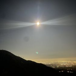
Scenic Night View in Altadena, California
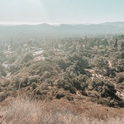
Hiking Trails in Altadena, California
Rock Climbing in Altadena, California
Creeks in Altadena, California
Shaded Hike in Altadena, California
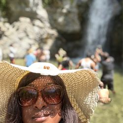
Waterfall Hike in Altadena, California
Stairs Workout in Altadena, California
Abandoned Places in Altadena, California
Easy Hikes in Altadena, California
Hiking Groups in Altadena, California
Off Leash Dog Hikes in Altadena, California
Fishing Spots in Altadena, California
Night Hiking in Altadena, California
Campgrounds in Altadena, California
Swimming Holes in Altadena, California
Forest in Altadena, California
Camping Sites in Altadena, California
Hiking Trails Kid Friendly in Altadena, California
Secluded Spots in Altadena, California
Sunrise Hike in Altadena, California
Trending Searches in Altadena, CA
4th Of July Fireworks in Altadena, CA
Black Owned Nail Salons in Altadena, CA
Jet Ski Rental in Altadena, CA
Off Road Trails in Altadena, CA
Outdoor Activities in Altadena, CA
Places To Walk Around in Altadena, CA
River Swimming in Altadena, CA
Running Trails in Altadena, CA
Scenic Night View in Altadena, CA
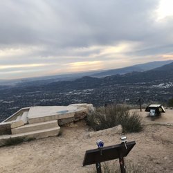
Scenic Overlook in Altadena, CA
Secluded Spots in Altadena, CA
Strawberry Picking in Altadena, CA
Swimming Holes in Altadena, CA
Browse Articles
Browse Nearby
BEST of Altadena, California Coffee near Dawn Mine Hike
BEST of Altadena, California Things to Do near Dawn Mine Hike
BEST of Altadena, California Restaurants near Dawn Mine Hike
BEST of Altadena, California Walking Trails near Dawn Mine Hike
BEST of Altadena, California Parks near Dawn Mine Hike
BEST of Altadena, California Breakfast near Dawn Mine Hike
BEST of Altadena, California Caves near Dawn Mine Hike
BEST of Altadena, California Hot Springs near Dawn Mine Hike
BEST of Altadena, California Campgrounds near Dawn Mine Hike
Browse Brands
Related Searches in Altadena, CA
Best Fishing Locations and Guides in Altadena, California
Best Nature Trails for Hiking in Altadena, California
Best Places for Horseback Riding in Altadena, California
Best Waterfalls and Swimming Holes in Altadena, California
Check Out Off Road Trails in Altadena, California
Discover Dog Friendly Trails to Explore in Altadena, California
Discover Kid Friendly Hiking Trails in Altadena, California
Discover Scenic Hiking Trails in Altadena, California
Discover Scenic Mountain Bike Trails Near Altadena, California
Discover Scenic Waterfall Spots in Altadena, California
Discover Walking Parks in Altadena, California Near You
Discover a Hiking Trail in Altadena, California
Discover the Best Night Hike Trails in Altadena, California
Discover the Best Running Track in Altadena, California
Dog-Friendly Hikes With Dogs in Altadena, California
Enjoy Camping Adventures Around Altadena, California
Enjoy Exciting Mountain Biking Adventures in Altadena, California
Enjoy Kayaking Adventures in Altadena, California
Enjoy Tent Camping Spots Around Altadena, California
Enjoy a Beautiful Waterfall Hike in Altadena, California
Enjoy a Peaceful Nature Walk in Altadena, California
Enjoy the Best Walking Path in Altadena, California
Enjoy the Best Walking Trails in Altadena, California
Exciting Cliff Jumping Spots in Altadena, California
Explore Beautiful Parks and Green Spaces in Altadena, California
Explore Easy Hikes Perfect for All in Altadena, California
Explore Fun Activities to Do in Altadena, California
Explore Popular Campgrounds Near Altadena, California
Explore the Best Beach Spots in Altadena, California
Explore the Best Trail Options in Altadena, California
Family Friendly Hiking With Kids in Altadena, California
Find Beautiful Views in Altadena, California
Find the Best Parks for Picnics in Altadena, California
Find the Best Scenic View Locations in Altadena, California
Great Places to Walk in Altadena, California
Hike the Popular Waterfall Trail in Altadena, California
Hiking Trails With Waterfalls in Altadena, California
Off Leash Dog Hiking Trails in Altadena, California
Plan a Scenic Drive Route Near Altadena, California
Popular Outdoor Activities to Try in Altadena, California
Popular Picnic Spots to Visit in Altadena, California
Safe River Swimming Areas in Altadena, California
Safe and Fun Parks for Kids in Altadena, California
Top Climbing Spots and Gyms in Altadena, California
Top Paddleboarding Activities in Altadena, California
Top Running Trails to Explore in Altadena, California
Top Swimming Lakes to Enjoy in Altadena, California
Top Swimming Spots and Pools in Altadena, California
People who viewed Dawn Mine Hike also viewed
El Prieto Trail
29 reviews
Tad Williams Trail
7 reviews
Mt Lowe
23 reviews
Eaton Canyon Natural Area
1330 reviews
Eagle Rock Canyon Trail
32 reviews
Pacific Palisades
Cooper Canyon Falls
24 reviews
Switzer Falls - USDA Forest Service
293 reviews
Devil's Canyon Trail
14 reviews
Eaton Canyon Falls Trail
13 reviews
Strawberry Peak
20 reviews