Beaudry Loop Hike Photos


You might also consider
More like Beaudry Loop Hike
Recommended Reviews - Beaudry Loop Hike
Start your review...

Reviews With Photos

Have you always wanted to get into hiking, but you listen to and or watch too much true murder podcast and are concerned you might be the next person featured on First 48? Well fear not, this spot if perfect for beginners and group hikes. The loop trail is on a big wide fire road that's easy to follow. The elevation on the incline is good enough to be a decent workout for beginners, and something that advanced hiker/trail runners can use to work on uphill endurance. Depends on which side of the trail you're on you can see the city of Glendale where the 2 freeway is, and on the other side you can see downtown LA and Burbank near the 5 freeway so you get a touch of nature mixed with views of the city for a little comfort knowing you aren't way out in the wilderness somewhere. Aside from the loop you can do some additional exploring to other trails from here. Since the trail is a fire road keep an eye out for mountain bikers riding downhill, they usually have bells on their bike so if you're hiking while listening to music make sure to keep one ear bud out to keep yourself and others safe.

I love this place! The path is wide and it's clean. Street park in the neighborhood at the trailhead and head on up! The inclines are gradual but not impossible. It's about 5 miles total and a fantastic workout. I recommend this trail for anyone who is tired of Griffith. I would go early to avoid the heat and bikers. The later you go, the more bikers there will be. Great view of the city at the top and it's a bit windy. I would go more often if I lived closer :) 2022 HIKE 6/52

Challenging but doable hike. Pleasure ensure you do whatever it takes to know where you're going, especially if you're bad with directions like me, because I got lost on the way down! Make sure your phone is fully charged too in the case that you get lost. Aside from that fiasco, I believe I stated with the S. Beaudry side which had a lot on inclines. Mile 1-2 was the hardest for me but mile 2-3 was pretty challenging for me as well. I am in pretty good shape and exercise regularly but I had to stop a few times in the way up to catch my breath. It's a well trafficked trail with lots of nice people. Several people said hello/good morning while I was doing this trail which I hardly experience in LA. I'd recommend wearing sunscreen /!: a hat/visor and bringing water. There's plenty of street parking in the residential area near where this trail starts on the Glendale side.

What's up: it's hike day with friends! I've never been in this area so it was a first for me. Early morning hikes are always good to avoid the crowds and the heat! Parking: Street parking is available. We didn't have to go too far to find a spot. The area is hilly so be careful. Environment: The hike has great views of the surrounding area. Slightly after you start on the trail, you'll find a fork in the road where it splits into Beaudry North and Beaudry South. Since it's a loop trail, you can pick either one. We went with the North trail. You'll steadily have inclines as you make your way up to the radio towers before finally ending up at the Tongva Peak after another fork in the road (be sure to pay attention to the signs posted). You'll have an awesome view of Los Angeles from there. And if you're into Pokemon Go, there were several Pokestops along the way too haha. Yay/Nay/Meh: Yay. This was a nice 5.5 mile loop hike that took us through several incline and declines to the Tongva Peak. On a clear day, you'll have lovely views of the nearby area. I don't recall seeing any restrooms nearby. But other than that, the trail was well maintained and easy to follow.

Beaudry Loop was a 5.7 mile hike that took around 2 hours and 15 minutes. Plenty of street parking in the residential area. Pretty much a steady upward climb, followed by a downward slope. Not too crowded and almost everyone was wearing a mask. Great views of the mountains in the Angeles National Forest and LA from a distance!

One of my favorite hikes. It's a great butt-burner and you feel accomplished at the top of the hike and at the bottom. If you want to be gentle on the knees/lower extremity joints, I would go up and down the north side because while the distance seems longer, the incline isn't as steep. The south side seems shorter, but there's a hefty incline to it, and it usually the side that gets all the sun. So if you're in it to get a nice booty and tan for the summer, you'll def wanna stick to the south side. There's a bench up top near the gates with a grand view of Glendale and Burbank. The Brand park trail also ends up there so it's pretty cool to see people coming up on different sides of the mountains. Busy but not too busy. Residential street parking in the area. Selfishly hoping this trail doesn't get too much heat so it stays nice and quiet.

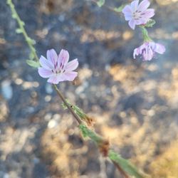
I seldom give less than 5 stars to a hike. That's how much I love being outside. This one deserves extra stars for the wonderful views in every direction. It's up up up then down down down. If you go clockwise up, that is the direction that is more steep. Either way, it's a moderate effort 5 mile loop. I saw about 20 lizards, squirrels, hawks, crows, and assorted other creatures. The flowers are blooming, but it's hot and they won't last. See them while you can. There were only two people on this trail who had their music blaring from a speaker they were carrying. It's a real plague in Oregon, so I was glad there were only two, but COME ON! Earbuds or nothing. It's incredibly selfish to impose your music on others. Thanks.

Free parking in a residential neighborhood at 3110 Beaudry Terrace. At the yellow steel sign go left on Beaudry S. which is all uphill. We got to close to a wild bee hive in a steel box at 1.6 miles. Continue up to 2.4 miles to reach cell tower, hang out area, rock balancing, and great views. You'll start heading down hill to loop back to the starting point.

Greetings! If you are reading this review then you have an interest in hiking the Beaudry Loop or you are reading, like I do, to see if we share the same experience :) This is a great hike for both beginner and intermediate hikers, but definitely be prepared for a steady and steep incline. I actually had a good laugh at the top of the trail and had great conversation with my calves about how I promised the next half was downhill! Hahaha! I am sure you will have the same conversation at some point during this hike. A few fair warnings for everyone, and it is well noted in other reviews, definitely bring plenty of water, wear protective clothing, hat, sunblock, and most importantly be aware of your surroundings. I have ran into several rattlesnakes during my hikes and have the pictures to prove it. I hope you enjoy the hike :)

This trail will give you stunning views of the L.A. Basin and quite the workout. It's a loop trail, almost six miles long, and well-maintained. It took me about three hours round trip but joggers were passing me by so it all depends on your rate of speed. I love that it's pretty much all uphill followed by all downhill on the way back. Park near the intersection of Beaudry Blvd. and Beaudry Terrace. You'll see a gate: enter and proceed up the path until you get to the intersection of Beaudry North and Beaudry South. Which way you take the loop depends on your personal preference and the weather: I decided to go counterclockwise and starting out, the North side was shady and cool. The South side was warm coming back, which was perfect since it was all downhill. Bring water and a camera!
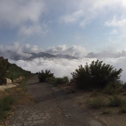
This hike was much better than I expected. My GF and I started at 7am sharp and ended at 920am. It only took us 2 hours and 20min to finish the 6 mile loop. I would say this hike is moderate. There is a steady incline but its nothing crazy like Mt Wilson or Inspiration Point. The trail is pretty easy to find as other Yelpers say. We started on North Beaudry. We came on a really foggy day which blocked the view of the cities BUT we got some really sick photos as if we were above the clouds. Good hike. Easy and free parking. Not crowded.

This hike is not for the faint of heart. I believe it's a full 7 miles if you do the entire loop but we ended up taking a shorter route which made it a total of 5 miles. I've attempted this hike once before and failed to do the loop as I started later in the day and wasn't able to finish it; however, I just recently went again with a few of my friends and this time was able to accomplish it within, I want to say 3-4 hours? I wasn't tracking it but it was a good hike--recommend going early to beat the heat or maybe in the afternoon so it's not hot. My only recommendation is to take the path on the right first when you come across the split at the Beaudry Loop since there's shading from the trees and it's much easier, as it felt like it was a steady incline. Also, when coming back down from the other side, it was steeper but much easier to come down than to hike uphill, which I did the first time I did this hike. A great, challenging hike for anyone who is currently looking for new places to climb. Due to the fires in Eaton Canyon and Malibu, there are less options to trek at the moment but this is a solid choice. This is nestled in a neighborhood so you'll end up parking your car either at the front entrance or in front of other people's homes. Will definitely come back again next time to conquer the full trail but with more ample time of course. read more


May your trails be long, crooked, lonesome, rugged leading to the most magnificent view. Now without further ado let's begin this glorious hike review. ;D Beaudry Loop Hike is a 5.5-mile loop trail located in Verdugo Mt near La Cresenta and Glendale, California. The trail is moderately challenging route, it takes an average of 3 hours to complete. Also, it has other interconnected trails within the loop. BLH is a popular area for hiking, mountain biking, dog walking and running, so you'll likely encounter other people while exploring. Furthermore, this loop trail has an elevation gain of 1,515 feet that provide gorgeous view of LA and surrounding cities. I hiked this loop trail on a cool Tuesday (12/06) morning where very little to no hikers on the trail. As you go deeper into the trail's bosom, you will see some wild plants and flowers and other creatures. The trails are very wide, well kept and has adequate shade on certain parts. The entrance of Beaudry Loop trail (intersection of Beaudry Terrace and Beaudry blvd) is somewhat hidden but a yellow metal thick gate is where you enter. There is one thing certain that no quiescent mind hiking this trailhead. As for parking, there are plenty of street parking around the neighborhood. In this voluminous review, it's time to make a conclusion. Overall, I enjoyed hiking this trail and it's magnificent view from the summit. I wholeheartedly recommend this trail. read more


 and South (L) Beaudry Trail. Go explore and have fun! - Hiking Near Me - Glendale, California")


4 years ago
A hidden gem!! It's in a residential neighborhood and the address that it gives you on Yelp is actually someone's house, but the trail starts right across the street (picture attached). You walk up about .40 miles and then it splits into Beaudry South and North. I decided to take the North path since I haven't hiked in a year even though I do work out a lot, but just in case! According to the reviews, the North path is a bit "less intense". I wasn't exactly sure where this hike ended, but I went to the radio towers/antennas so RT was 5.6 miles and it took me 1 hour and 30 min. On the North path there was at least 35% shade at 8:50am when I started. It was a steady incline with 4 or 5 places where it flattened for about 5 steps lol, I didn't stop during this hike at all. Faster you go, faster you get it over with ;) I saw more people when I was coming down and lots of mountain bikers...kudos to them. My thighs were burning for them! I'll definitely be back to try the South path! read more
 - Hiking Near Me - Glendale, California")


Have you always wanted to get into hiking, but you listen to and or watch too much true murder podcast and are concerned you might be the next person featured on First 48? Well fear not, this spot if perfect for beginners and group hikes. The loop trail is on a big wide fire road that's easy to follow. The elevation on the incline is good enough to be a decent workout for beginners, and something that advanced hiker/trail runners can use to work on uphill endurance. Depends on which side of the trail you're on you can see the city of Glendale where the 2 freeway is, and on the other side you can see downtown LA and Burbank near the 5 freeway so you get a touch of nature mixed with views of the city for a little comfort knowing you aren't way out in the wilderness somewhere. Aside from the loop you can do some additional exploring to other trails from here. Since the trail is a fire road keep an eye out for mountain bikers riding downhill, they usually have bells on their bike so if you're hiking while listening to music make sure to keep one ear bud out to keep yourself and others safe. read more


I love this place! The path is wide and it's clean. Street park in the neighborhood at the trailhead and head on up! The inclines are gradual but not impossible. It's about 5 miles total and a fantastic workout. I recommend this trail for anyone who is tired of Griffith. I would go early to avoid the heat and bikers. The later you go, the more bikers there will be. Great view of the city at the top and it's a bit windy. I would go more often if I lived closer :) 2022 HIKE 6/52 read more


Challenging but doable hike. Pleasure ensure you do whatever it takes to know where you're going, especially if you're bad with directions like me, because I got lost on the way down! Make sure your phone is fully charged too in the case that you get lost. Aside from that fiasco, I believe I stated with the S. Beaudry side which had a lot on inclines. Mile 1-2 was the hardest for me but mile 2-3 was pretty challenging for me as well. I am in pretty good shape and exercise regularly but I had to stop a few times in the way up to catch my breath. It's a well trafficked trail with lots of nice people. Several people said hello/good morning while I was doing this trail which I hardly experience in LA. I'd recommend wearing sunscreen /!: a hat/visor and bringing water. There's plenty of street parking in the residential area near where this trail starts on the Glendale side. read more


What's up: it's hike day with friends! I've never been in this area so it was a first for me. Early morning hikes are always good to avoid the crowds and the heat! Parking: Street parking is available. We didn't have to go too far to find a spot. The area is hilly so be careful. Environment: The hike has great views of the surrounding area. Slightly after you start on the trail, you'll find a fork in the road where it splits into Beaudry North and Beaudry South. Since it's a loop trail, you can pick either one. We went with the North trail. You'll steadily have inclines as you make your way up to the radio towers before finally ending up at the Tongva Peak after another fork in the road (be sure to pay attention to the signs posted). You'll have an awesome view of Los Angeles from there. And if you're into Pokemon Go, there were several Pokestops along the way too haha. Yay/Nay/Meh: Yay. This was a nice 5.5 mile loop hike that took us through several incline and declines to the Tongva Peak. On a clear day, you'll have lovely views of the nearby area. I don't recall seeing any restrooms nearby. But other than that, the trail was well maintained and easy to follow. read more


 - Hiking Near Me - Glendale, California")


Beaudry Loop was a 5.7 mile hike that took around 2 hours and 15 minutes. Plenty of street parking in the residential area. Pretty much a steady upward climb, followed by a downward slope. Not too crowded and almost everyone was wearing a mask. Great views of the mountains in the Angeles National Forest and LA from a distance! read more


One of my favorite hikes. It's a great butt-burner and you feel accomplished at the top of the hike and at the bottom. If you want to be gentle on the knees/lower extremity joints, I would go up and down the north side because while the distance seems longer, the incline isn't as steep. The south side seems shorter, but there's a hefty incline to it, and it usually the side that gets all the sun. So if you're in it to get a nice booty and tan for the summer, you'll def wanna stick to the south side. There's a bench up top near the gates with a grand view of Glendale and Burbank. The Brand park trail also ends up there so it's pretty cool to see people coming up on different sides of the mountains. Busy but not too busy. Residential street parking in the area. Selfishly hoping this trail doesn't get too much heat so it stays nice and quiet. read more


3 years ago
I seldom give less than 5 stars to a hike. That's how much I love being outside. This one deserves extra stars for the wonderful views in every direction. It's up up up then down down down. If you go clockwise up, that is the direction that is more steep. Either way, it's a moderate effort 5 mile loop. I saw about 20 lizards, squirrels, hawks, crows, and assorted other creatures. The flowers are blooming, but it's hot and they won't last. See them while you can. There were only two people on this trail who had their music blaring from a speaker they were carrying. It's a real plague in Oregon, so I was glad there were only two, but COME ON! Earbuds or nothing. It's incredibly selfish to impose your music on others. Thanks. read more


6 years ago
Free parking in a residential neighborhood at 3110 Beaudry Terrace. At the yellow steel sign go left on Beaudry S. which is all uphill. We got to close to a wild bee hive in a steel box at 1.6 miles. Continue up to 2.4 miles to reach cell tower, hang out area, rock balancing, and great views. You'll start heading down hill to loop back to the starting point. read more

Greetings! If you are reading this review then you have an interest in hiking the Beaudry Loop or you are reading, like I do, to see if we share the same experience :) This is a great hike for both beginner and intermediate hikers, but definitely be prepared for a steady and steep incline. I actually had a good laugh at the top of the trail and had great conversation with my calves about how I promised the next half was downhill! Hahaha! I am sure you will have the same conversation at some point during this hike. A few fair warnings for everyone, and it is well noted in other reviews, definitely bring plenty of water, wear protective clothing, hat, sunblock, and most importantly be aware of your surroundings. I have ran into several rattlesnakes during my hikes and have the pictures to prove it. I hope you enjoy the hike :) read more


This trail will give you stunning views of the L.A. Basin and quite the workout. It's a loop trail, almost six miles long, and well-maintained. It took me about three hours round trip but joggers were passing me by so it all depends on your rate of speed. I love that it's pretty much all uphill followed by all downhill on the way back. Park near the intersection of Beaudry Blvd. and Beaudry Terrace. You'll see a gate: enter and proceed up the path until you get to the intersection of Beaudry North and Beaudry South. Which way you take the loop depends on your personal preference and the weather: I decided to go counterclockwise and starting out, the North side was shady and cool. The South side was warm coming back, which was perfect since it was all downhill. Bring water and a camera! read more


 - Hiking Near Me - Glendale, California")

2 years ago
This hike was much better than I expected. My GF and I started at 7am sharp and ended at 920am. It only took us 2 hours and 20min to finish the 6 mile loop. I would say this hike is moderate. There is a steady incline but its nothing crazy like Mt Wilson or Inspiration Point. The trail is pretty easy to find as other Yelpers say. We started on North Beaudry. We came on a really foggy day which blocked the view of the cities BUT we got some really sick photos as if we were above the clouds. Good hike. Easy and free parking. Not crowded. read more


3 years ago
Stunning and worthwhile evening hike. We started at 7pm and it took roughly 2-2.5 hours for the 6 mile loop. We saw a few people doing the evening hike, but not too many. Most of the hike was out in the open and not shaded at all, so if you go during the day, be sure to wear tons of sunscreen and bring lots of water! Start at the trailhead, which you can find by just googling Beaudry Loop Hike trailhead. A few minutes in, you can choose to go either North or South. We chose North.. don't think it makes much of a difference. Once you're at the top (it's a gated area of the posts), walk along the ledge of the fence so that you can get to the open space right beside the gated area. There is a bench there and a nice view. It gets pretty dark so bring a flashlight if you can! We used our phone lights for the way down. PARKING: Tons of street parking. read more

Spent my morning at this trail. My co worker has been here a few times and so I asked him to go with me since it is my first time. Parking isn't hard as there's plenty of street parking. The trail is located inside a residential upscale community of La Crescenta. You have the option of the Beaudry South or North. South is shorter I believe but with a lot of incline. Definitely not for beginners like me. The North is longer but way less incline. So we did the north trail. I wanted to give up a few times but pushed myself to finish the hike. It is over 5 miles back and forth. It is doable but I cant really say that it's for beginners like myself. The view from the tower is so worth it. There is a bench where you can relax and take pics and even meditate. Anyway I will be back for sure. read more


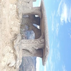
The Beaudry Loop Hike is one my favorite hikes in the Verdugo Mountains because there's plenty of places to soak up the view once you get to the top. STATISTICS FOR THE TRAIL: 5.5 Miles for this lollipop shaped hike on fire roads. 1,500 feet gain and loss. Time: Approximately 3 1/2 hours DIRECTIONS TO THE TRAIL: It's right up the street from Oakmont Country Club in Glendale. From Canada Blvd heading north turn left on Santa Maria and an immediate right on Country Club Drive. Turn left on Beaudry Bouelvard and go to the end. The trail starts right where Beaudry Boulevard meets Beaudry Terrace. There's plenty of parking along this residential street. TRAIL INFO: I recommend doing the loop in a clockwise rotation so you would take Beaudry South when you get to the sign that shows both. There's lots of shade if you start early. Once you get to the top you will see a tower to your left. This is at the top of Mt. Thom. I like going up there and walking along the fence to the little plateau. There is a rock that has some graffiti on it that you can take a photo on. Then head north toward the cluster of transmission towers, but before you get there you'll see a trail that goes to the left and up to a big slab of concrete. This is a great place to take a break or have a picnic. I really want to come up here at sunset one day because I haven't done that yet. I bet the view of the lights in the city would be amazing. Anyone want to go? Maybe I'll plan a group hike to do this in the near future. After your break head toward the transmission towers just north of the slab. If you walk along the fence to the south of the towers you will find the marker for Tongva Peak. See my photo. This is also a nice place to take a little break and there's one place to sit down for a couple people. The thing that can be a little annoying to me is some people think the marker is a bench so they'll sit on that and then other hikers can't see it. To get back to the north part of the look keep heading north past the transmission towers and you will see the fire road heading downhill about a 1/4 mile north of the towers. THINGS TO REMEMBER: - Bring water. - Bring something to eat. It's nice to have a little picnic when you get to the top. - Wear sunscreen and a hat. VERDUGO MOUNTAINS INFO: If you feel energetic you can continue hiking west on Verdugo Motorway to the rest of the peaks in the Verdugo Mountains before heading back down. You could also leave a friend's car somewhere else in case you want to go down the other side and not come back up. There are many other fire roads and trails that will take you to the top of the Verdugo Mountains such as: - Las Flores Motorway Trail (Glendale) - Whiting Woods (Glendale/La Crescenta) - Brand Park (Glendale) - This would be a good one to leave a car at Beaudry Blvd. - La Tuna Canyon Trail (Tujunga right off the 210 Freeway) - Wildwood Canyon (Burbank) - Stough Canyon Nature Center (Burbank) read more


Love it, hate it, but I know for sure you'll love it! ...and here's why! This is the kind of hike that will give you the "behind" you've always longed for, just when you thought you have reached the top, somewhere along the curve and behind the fog is another uphill battle for you to conquer! Beaudry Loop is a hidden gem of Glendale, the dirt trails are nice (fire trails I believe) and provides a level of activity for those brave enough to have a full anaerobic workout. The steep grade of this trail is definitely not for the beginner hiker but definitely for those who crave for a "never-ending" uphill trek. Although there is not much trees going up, the downhill part is such a great relief as you will be greeted by trees and vegetation, and of course a view that makes you appreciate mother earth's artistic hands. As with any hike, reaching the top is the ultimate goal, I suggest stopping briefly (not just to catch your breath) but also to enjoy the beauty of nature on a somewhat birds-eye view way...it is AMAZING! I was really hesitant to write this review as to not reveal this amazing hiking spot to the general public but something this amazing must be shared to all avid hikers and nature lovers out there as this is one of those hikes that will truly get your heart (your thigh, calves, bum) pounding. Enjoy! read more

 - Hiking Near Me - Glendale, California")

Last Saturday I went on a night hike at this hiking trail with a group of 30 people and absolutely loved it. I was able to see the sunset over the horizon and the view of smoggy DTLA before the sun went down. :( What to bring for night hike: Bring at least 3 liters of water, flashlight, a light jacket, and maybe a snack to enjoy when you are at the top. Location: Take the CA-2 or Glendale Blvd. north into Glendale. If you're taking the 2, exit at Mountain Street and turn left. In 0.5 miles, turn right onto Verdugo Road, which becomes Canada Blvd. In 1.8 miles, take a left at the light onto Country Club Drive, and follow this road for 0.4 miles before taking a left onto Beaudry Blvd. Drive another 0.4 miles to where the road makes a sharp right hand turn on a steep incline. You'll see a flood control near the trail head. Distance/Trail Type: 6 miles loop trail with a elevation gain of 1368ft. For the most part, you'll be on a fire road that is a car length wide that takes you to the top. You can either take Beaudry S or Beaudry N first. At times, it can be steep. So take your time and enjoy. Duration: Roughly 3 hours at a steady pace. Recommendation: I would recommend taking Beaudry South first. You'll see the lights of DTLA and the surrounding residential area. It's a wonderful view to relax and get away from your daily stresses for a bit. read more


Great hike for a good cardio work out. We took the easier route, the North Beaudry route up and then down the South Beaudry side. According to my Runkeeper app, the hike was a total of 5.5 miles and took about 2.5 hours to complete the loop. Prepare for a doable up hill climb to reach the top. As you round the mountain, some parts were shaded so thats where I slowed down to catch my breath and to enjoy the Jaunary breeze. Going down I ended up just jogging down since your body is being pushed down anyway. Park in the residential neighborhood at the end of Beaudry Terrace to begin the hike. read more


8 years ago
3 years ago
10 years ago
This is a really nice hike if you live nearby and are looking to get outside for something quick and easy. As an avid hiker, I'd definitely label this a beginner hike. The sort of thing you could probably bring your grandmother on. You are on a fire road the entire time, so you never get a real sense of being on a dirt trail or too far from civilization. If you are looking for that true connection to the wilderness, it may be tough to find it here. You will find a well marked road which is completely easy to follow, tons of wildflowers, a cool breeze at times, pockets of sunshine depending on the day/time/weather, decent 360 views of the LA/SFV area. The trail was not crowded at all which is really one of the big pros here. It's a little under 6 miles which feels more like a neighborhood stroll to me, but a nice way to get some fresh air and vitamin D. No permits required for parking on the street at the trailhead. The entire hike took us less than the Hamilton soundtrack to get through, so it's definitely what I would sum up as short and sweet. As always don't forget your sunscreen, water is always a good idea (although I didn't drink very much), a snack isn't a terrible idea but for this distance it's not likely you'll need much. read more


8 years ago
Great for beginner hikers and those who are looking for an easy going, quick workout! This trail is tucked away in a residential area in Glendale and it's one of my favorite gems outside of the city n__n WHY I LOVE THIS TRAIL: 1. quiet & never crowded 2. lots of greenery & shade 3. plenty of free parking 4. wide trail that gives you a lot of space to jog or run 5. suitable for mountain biking It took me 2 hours to finish the 6 mile hike. The incline is not steep so running to and fro is definitely possible. I feel like this trail was more of a relaxing warm-up than a cardio workout. But if you want more of a work out, go on the south trail since it's way steeper. Loved getting away from the city for a bit!! read more


5 years ago
Excellent 5.5mi workout. Like below reviews have been say, the South Loop is definitely the more intense loop as the elevation gain is over a shorter mileage. The fork for the loops is about a half mile down the trail; the signage is pretty clear. The trail is exposed to sun almost entirely, except at the beginning and a few small random overhanging trees that are along your route. However, if you go in the morning (I did it before 10:30 in May) on the South Loop, you will have some of the hills' shadows still and thus a lot of shade while you're on the uphill. If you go more midday though, prepare for an awesome tank top tan or sunburn, depending on your genetics... Scenery is meh, and better on the South Loop (more greenery, less shrubby chaparral), but the view from the top is great - downtown Glendale, Burbank, and DTLA in the distance - post-rain or post-wind in the fall or winter probably is the best time to go for the clearest and farthest views! Parking is easy and free - at the top of Beaudry Terrace. The trailhead is next to the river runoff area, and looks like a paved residential driveway - don't be fooled though as it quickly becomes a dirt fire road. read more


2 years ago
8 years ago
This is a good hiking fix if you're near the Glendale area. It's free and parking is in a safe residential area. The trail loops about 6 miles. Once you hit the fork, you can go either Beaudry South or North as it loops. South seems a little more steeper than North. Not a lot of shade so pack accordingly to the weather. You will hike towards Tongva Peak and Mount Thom. Other than that, it's a good hike. If want a little more challenge, try Wildwood Canyon, the vital link trail to Verdugo peak, or maybe bailey canyon to jones peak. read more


5 years ago

8 years ago
Page 1 of 4
More info about Beaudry Loop Hike
3110 Beaudry Ter
Glendale, CA 91208
Directions
Hours
Indoor Amenities
Outdoor Amenities
Ask the Community - Beaudry Loop Hike
Due to covid19, is this park still open today?
If you search online you will see all Glendale trails are closed which includes this trail. Adjacent La Canada and L.A. County trails are also closed due to the pandemic.… Read more
Review Highlights - Beaudry Loop Hike
You might also consider


Why does Yelp recommend reviews?
Beaudry Loop Hike - hiking - Updated June 2026
Best of Glendale
People found Beaudry Loop Hike by searching for…
Hiking Trails in Glendale, California
Scenic View in Glendale, California
Waterfall Hike in Glendale, California
Free Snow Play in Glendale, California
Walking Trails in Glendale, California
Easy Hikes in Glendale, California
Beautiful Views in Glendale, California
Lookout Points in Glendale, California
Running Trails in Glendale, California
Places to Watch Sunset in Glendale, California
Things to Do in Glendale, California
Hiking Club in Glendale, California
Sunrise View in Glendale, California
Places to Take Pictures in Glendale, California
Bike Paths in Glendale, California
Scenic Overlook in Glendale, California
Shaded Hike in Glendale, California
Hiking Trails Kid Friendly in Glendale, California
Scenic Drives in Glendale, California
Sunrise Hike in Glendale, California
Places to Run in Glendale, California
Trending Searches in Glendale, CA
Black Owned Nail Salons near Beaudry Loop Hike
Boat Rental near Beaudry Loop Hike
Cliff Jumping near Beaudry Loop Hike
Day Trips near Beaudry Loop Hike
Dog Friendly Trails near Beaudry Loop Hike
Fishing Spots near Beaudry Loop Hike
Jet Ski Rental near Beaudry Loop Hike
Kayak Rental near Beaudry Loop Hike
Lakes & Ponds near Beaudry Loop Hike
Off Road Trails near Beaudry Loop Hike
Outdoor Activities near Beaudry Loop Hike
Places To Walk Around near Beaudry Loop Hike
Public Pools near Beaudry Loop Hike
Public Shower near Beaudry Loop Hike
River Swimming near Beaudry Loop Hike
Rock Quarry near Beaudry Loop Hike
Scenic Night View near Beaudry Loop Hike
Scenic Overlook near Beaudry Loop Hike
Secluded Spots near Beaudry Loop Hike
Soccer Store near Beaudry Loop Hike
Splash Pad near Beaudry Loop Hike
Strawberry Picking near Beaudry Loop Hike
Sunrise View near Beaudry Loop Hike
Swimming Holes near Beaudry Loop Hike
Swimming Lakes near Beaudry Loop Hike
U Pick Farms near Beaudry Loop Hike
Watch Sunset near Beaudry Loop Hike
Browse Articles
Browse Nearby
BEST of Glendale, California Coffee near Beaudry Loop Hike
BEST of Glendale, California Restaurants near Beaudry Loop Hike
BEST of Glendale, California Things to Do near Beaudry Loop Hike
BEST of Glendale, California Walking Trails near Beaudry Loop Hike
BEST of Glendale, California Parks near Beaudry Loop Hike
BEST of Glendale, California Breakfast near Beaudry Loop Hike
BEST of Glendale, California Caves near Beaudry Loop Hike
BEST of Glendale, California Hot Springs near Beaudry Loop Hike
BEST of Glendale, California Campgrounds near Beaudry Loop Hike
Browse Brands
Related Searches in Glendale, CA
Affordable Kayak Rental Services in Glendale, California
Best Fishing Locations and Guides in Glendale, California
Best Nature Trails for Hiking in Glendale, California
Best Places for Horseback Riding in Glendale, California
Check Out Off Road Trails in Glendale, California
Discover Dog Friendly Trails to Explore in Glendale, California
Discover Kid Friendly Hiking Trails in Glendale, California
Discover Scenic Hiking Trails in Glendale, California
Discover Scenic Mountain Bike Trails Near Glendale, California
Discover Scenic Waterfall Spots in Glendale, California
Discover Walking Parks in Glendale, California Near You
Discover a Hiking Trail in Glendale, California
Discover the Best Night Hike Trails in Glendale, California
Discover the Best Running Track in Glendale, California
Dog-Friendly Hikes With Dogs in Glendale, California
Enjoy Camping Adventures Around Glendale, California
Enjoy Exciting Mountain Biking Adventures in Glendale, California
Enjoy Kayaking Adventures in Glendale, California
Enjoy Tent Camping Spots Around Glendale, California
Enjoy a Beautiful Waterfall Hike in Glendale, California
Enjoy a Peaceful Nature Walk in Glendale, California
Enjoy the Best Walking Path in Glendale, California
Enjoy the Best Walking Trails in Glendale, California
Exciting Cliff Jumping Spots in Glendale, California
Explore Beautiful Parks and Green Spaces in Glendale, California
Explore Easy Hikes Perfect for All in Glendale, California
Explore Fun Activities to Do in Glendale, California
Explore Popular Campgrounds Near Glendale, California
Explore the Best Beach Spots in Glendale, California
Explore the Best Trail Options in Glendale, California
Family Friendly Hiking With Kids in Glendale, California
Find Beautiful Views in Glendale, California
Find the Best Parks for Picnics in Glendale, California
Find the Best Scenic View Locations in Glendale, California
Great Places to Walk in Glendale, California
Hike the Popular Waterfall Trail in Glendale, California
Hiking Trails With Waterfalls in Glendale, California
Off Leash Dog Hiking Trails in Glendale, California
Plan a Scenic Drive Route Near Glendale, California
Popular Outdoor Activities to Try in Glendale, California
Popular Picnic Spots to Visit in Glendale, California
Safe River Swimming Areas in Glendale, California
Safe and Fun Parks for Kids in Glendale, California
Top Climbing Spots and Gyms in Glendale, California
Top Paddleboarding Activities in Glendale, California
Top Running Trails to Explore in Glendale, California
Top Swimming Lakes to Enjoy in Glendale, California
Top Swimming Spots and Pools in Glendale, California
People who viewed Beaudry Loop Hike also viewed
Descanso Trail
18 reviews
Cherry Canyon Park
24 reviews
La Canada Teepee
18 reviews
Scholl Canyon Fire Road Trailhead
7 reviews
Las Flores Motorway Trail
10 reviews
Flint Canyon Trail
8 reviews
Glendale Narrows Riverwalk
20 reviews
El Prieto Trail
28 reviews
Oro Vista Park
7 reviews
Sunland
Verdugo Mountains
30 reviews