
Flint Canyon Trail Photos


You might also consider
More like Flint Canyon Trail
Recommended Reviews - Flint Canyon Trail
Start your review...

Reviews With Photos

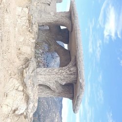
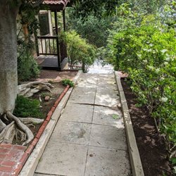
The Flint Canyon Trail runs from Cherry Canyon on the west side of La Canada-Flintridge to Hahamongna Watershed Park on the east side of town. The Flint Canyon Trail is primarily a multi use trail for walkers, hikers, runners, bikers and horseback riders. It is a total of 2.03 miles from one end to the other. There are so many opportunities for extending the length of your hike on either end by hiking around Hahamongna Watershed Park and on to the Gabrielino Trail which heads north in the Arroyo Seco. If you end up on Hamstead Rd. you can cross the street and access the multitudes of trails at Cherry Canyon Park. I've lived in La Canada-Flintridge for 13 years and today is the first time I stepped foot on the Flint Canyon Trail. I hesitated to hike on it in the past because I thought I might get a little depressed every time I'd see a horse. I had horses growing up and really miss them, but they are really expensive and time consuming to actually own. I'd have to say I am really happy I finally went hiking on this trail for a few reasons. The first one being that my son helped his Troop 507 work on a couple Boy Scout Eagle projects on this trail and I just had to see it for myself. It wasn't my son's project, but all the scouts in the troop always help when projects come up. This is a subject of controversy in the local paper right now because of the plaques that were placed on the ground with the names of the two Eagle Scouts in Troop 507. The La Canada Trails Council (see website link) who is in charge of maintaining the trails don't want plaques all over the trails. The parents of these two Eagle Scouts, a few other parents (not including myself) and scoutmasters don't really agree with that because it was a pretty labor intensive project to build log fences on the east and west entrances of the trail from Commonwealth Avenue. I posted a couple photos of the log fence that was installed. Personally, I don't think the scouts need this type of recognition in the form of a fancy plaque and I think that goes against what scouting is all about. I'm just the mom of a scout so that's just my opinion. My husband spoke to a county worker today because our troop is in the process of building another fence by a trail in Altadena and he thought a small plaque placed on the actual fence would be good. I think I like that idea the most so far. No it isn't named after Larry Flint if that's what you are thinking, but I still need to do a little research on it. Summer is here and if you want to get out and hike without dying of heat stroke in the blazing hot sun this is a nice little trail. Pros: * This is a really easy hike and you can wear your comfy tennis shoes if you want. * One great thing about this trail is that it is mostly shaded by mature oaks, sycamores, and other trees. Watch out for the poison oak. * Not difficult although a little hill climb on the west end by Hampstead Road and another one at the opposite end by Berkshire just past Dover Rd. * The Hampstead Road entrance to the trail is right across the street from the main entrance to Cherry Canyon. Cons: * No restrooms until you make it to Hahamongna Watershed Park. They are near the road approximately across the street from La Canada High School's pool as a landmark. * Parking can be limited at the Hampstead Rd. entrance so you might want to start at Hahamongna Park close to the intersection of Oak Grove and Berkshire. * The short section of the trail that goes under the 210 freeway is a little scary. Either brush up on your karate skills, carry a pocket knife or hike with a friend. * The eastern section of the trail is very close to the 210 which I wrote about above therefore the sound of the traffic is really annoying. I'm not going to sugar coat it. That's one reason I hate living close to the 210 and I am praying the 710 extension doesn't go through. All I need is 50 million more 18 wheelers cruising through town honking their horns at midnight. Tips: * Bring your water. That is a no brainer. * Possibly pack a lunch. There are lots of places to have a little picnic at Hahamongna or Cherry Canyon. * Wear your sunscreen. The Flint Canyon Trail is mostly shaded by mature trees, but Hahamongna and Cherry Canyon are pretty exposed. * Bring a pocket knife if you are planning on going under the 210 freeway. * Watch out for snakes and poison oak.

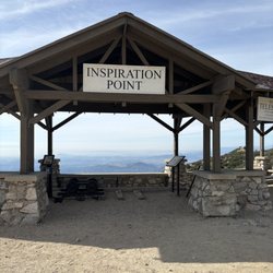
Happiness does have a smell. And that's nature. Let us begin this hiking trail review. Flint Canyon Trail is a short loop half-mile trail Cherry Canyon Park that connects Owl Trail to Cerro Negro Trail. It's located in Hampstead Rd and Cherry Canyon Motorway in La Cañada Flintridge, CA. I arrived late Friday mornin. The trail is considered easy to moderate for experienced hikers with an elevation gain of 390 feet. The lower section of the trail is surrounded by oak trees which provide shade as you go through the hike. This trail's upper section intersects portion of Cerro Negro-Owl Trail which has steep incline that leads to Five Points and Sugar Loaf. The trail is doggo friendly, single friendly, married friendly, family friendly, good for running, biking and dancing. Lol. ;D The trails were well kept and easy to navigate thanks to direction sign posts. I spent roughly 2 hours (6.07 km) hiking, a perfect cardio workout. As for parking, there's no designated parking area for visitors. Thus, park along Hampstead road but careful the road has Tow Away Zone. Overall, I enjoyed hiking Flint canyon trail and it's other interconnected trails. I recommend this trailhead. read more


4 years ago
We went on a Sunday morning. Lots of people walking their horses which we enjoyed watching. Because there was a lot of rain, there were parts that were muddy. I took a stroller and was able to get through a good amount even with it being muddy then needed help. But I believe if it wasn't so muddy, going with a stroller wouldn't be much difficult. read more
The Flint Canyon Trail runs from Cherry Canyon on the west side of La Canada-Flintridge to Hahamongna Watershed Park on the east side of town. The Flint Canyon Trail is primarily a multi use trail for walkers, hikers, runners, bikers and horseback riders. It is a total of 2.03 miles from one end to the other. There are so many opportunities for extending the length of your hike on either end by hiking around Hahamongna Watershed Park and on to the Gabrielino Trail which heads north in the Arroyo Seco. If you end up on Hamstead Rd. you can cross the street and access the multitudes of trails at Cherry Canyon Park. I've lived in La Canada-Flintridge for 13 years and today is the first time I stepped foot on the Flint Canyon Trail. I hesitated to hike on it in the past because I thought I might get a little depressed every time I'd see a horse. I had horses growing up and really miss them, but they are really expensive and time consuming to actually own. I'd have to say I am really happy I finally went hiking on this trail for a few reasons. The first one being that my son helped his Troop 507 work on a couple Boy Scout Eagle projects on this trail and I just had to see it for myself. It wasn't my son's project, but all the scouts in the troop always help when projects come up. This is a subject of controversy in the local paper right now because of the plaques that were placed on the ground with the names of the two Eagle Scouts in Troop 507. The La Canada Trails Council (see website link) who is in charge of maintaining the trails don't want plaques all over the trails. The parents of these two Eagle Scouts, a few other parents (not including myself) and scoutmasters don't really agree with that because it was a pretty labor intensive project to build log fences on the east and west entrances of the trail from Commonwealth Avenue. I posted a couple photos of the log fence that was installed. Personally, I don't think the scouts need this type of recognition in the form of a fancy plaque and I think that goes against what scouting is all about. I'm just the mom of a scout so that's just my opinion. My husband spoke to a county worker today because our troop is in the process of building another fence by a trail in Altadena and he thought a small plaque placed on the actual fence would be good. I think I like that idea the most so far. No it isn't named after Larry Flint if that's what you are thinking, but I still need to do a little research on it. Summer is here and if you want to get out and hike without dying of heat stroke in the blazing hot sun this is a nice little trail. Pros: * This is a really easy hike and you can wear your comfy tennis shoes if you want. * One great thing about this trail is that it is mostly shaded by mature oaks, sycamores, and other trees. Watch out for the poison oak. * Not difficult although a little hill climb on the west end by Hampstead Road and another one at the opposite end by Berkshire just past Dover Rd. * The Hampstead Road entrance to the trail is right across the street from the main entrance to Cherry Canyon. Cons: * No restrooms until you make it to Hahamongna Watershed Park. They are near the road approximately across the street from La Canada High School's pool as a landmark. * Parking can be limited at the Hampstead Rd. entrance so you might want to start at Hahamongna Park close to the intersection of Oak Grove and Berkshire. * The short section of the trail that goes under the 210 freeway is a little scary. Either brush up on your karate skills, carry a pocket knife or hike with a friend. * The eastern section of the trail is very close to the 210 which I wrote about above therefore the sound of the traffic is really annoying. I'm not going to sugar coat it. That's one reason I hate living close to the 210 and I am praying the 710 extension doesn't go through. All I need is 50 million more 18 wheelers cruising through town honking their horns at midnight. Tips: * Bring your water. That is a no brainer. * Possibly pack a lunch. There are lots of places to have a little picnic at Hahamongna or Cherry Canyon. * Wear your sunscreen. The Flint Canyon Trail is mostly shaded by mature trees, but Hahamongna and Cherry Canyon are pretty exposed. * Bring a pocket knife if you are planning on going under the 210 freeway. * Watch out for snakes and poison oak. read more


This is a pretty good hike if you're a beginner, or just getting back into hiking after a ridiculously long period of being a couch potato (as was the case with me). I did Liz's Loop which is just over a mile long, and took me about 25 minutes going at a leisurely pace. It's fairly easy with only a few inclines, and is decently wide in most areas. Parking in the area is pretty easy since it's a residential area, but I'd imagine the spots closest to the trailhead on Hampstead Road would be taken up pretty quickly on the weekend (but if you're going for a hike, a bit of a walk shouldn't pose a problem). I came here on a Tuesday morning, and only two other cars were present, and I ran into a whopping three people, and a dog during my little trek. read more


13 years ago
12 years ago
More info about Flint Canyon Trail
Ask the Community - Flint Canyon Trail
You might also consider


Flint Canyon Trail - hiking - Updated July 2026
Best of La Cañada Flintridge
People found Flint Canyon Trail by searching for…
Hiking Trails in La Cañada Flintridge, CA
Shaded Hike in La Cañada Flintridge, CA
Places to Take Pictures in La Cañada Flintridge, CA
Things to Do for Kids in La Cañada Flintridge, CA
Beautiful Views in La Cañada Flintridge, CA
Running Trails in La Cañada Flintridge, CA
Easy Hikes in La Cañada Flintridge, CA
Parks in La Cañada Flintridge, CA
Stroller Friendly Hikes in La Cañada Flintridge, CA
Star Gazing in La Cañada Flintridge, CA
Bike Paths in La Cañada Flintridge, CA
Walking Trails in La Cañada Flintridge, CA
Sunrise View in La Cañada Flintridge, CA
Picnic Areas in La Cañada Flintridge, CA
Views in La Cañada Flintridge, CA
Waterfall Hike in La Cañada Flintridge, CA
Stroller Walk in La Cañada Flintridge, CA
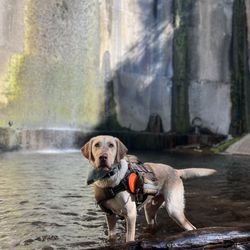
Dog Friendly Hiking Trails in La Cañada Flintridge, CA
Photo Spots in La Cañada Flintridge, CA
Cheap Fun Things to Do in La Cañada Flintridge, CA
Lookout Points in La Cañada Flintridge, CA
Trails in La Cañada Flintridge, CA
Trending Searches in La Cañada Flintridge, CA
Blueberry Picking near Flint Canyon Trail
Boating near Flint Canyon Trail
Cliff Jumping near Flint Canyon Trail
Creeks near Flint Canyon Trail
Day Trips near Flint Canyon Trail
Dog Friendly Things To Do near Flint Canyon Trail
Jet Skis near Flint Canyon Trail
Kayak Rental near Flint Canyon Trail
Off Road Trails near Flint Canyon Trail
Outdoor Activities near Flint Canyon Trail
Peach Picking near Flint Canyon Trail
Picnic Spots near Flint Canyon Trail
Public Pools near Flint Canyon Trail
Public Shower near Flint Canyon Trail
River Swimming near Flint Canyon Trail
Rock Quarry near Flint Canyon Trail
Scenic Night View near Flint Canyon Trail
Scenic Overlook near Flint Canyon Trail
Surf Shop near Flint Canyon Trail
Swimming Holes near Flint Canyon Trail
Swimming Lakes near Flint Canyon Trail
Things To Do On A Rainy Day near Flint Canyon Trail
U Pick Farms near Flint Canyon Trail
Watch Sunset near Flint Canyon Trail
Browse Articles
Browse Nearby
BEST of La Cañada Flintridge, California Coffee near Flint Canyon Trail
BEST of La Cañada Flintridge, California Things to Do near Flint Canyon Trail
BEST of La Cañada Flintridge, California Restaurants near Flint Canyon Trail
BEST of La Cañada Flintridge, California Walking Trails near Flint Canyon Trail
BEST of La Cañada Flintridge, California Parks near Flint Canyon Trail
BEST of La Cañada Flintridge, California Breakfast near Flint Canyon Trail
BEST of La Cañada Flintridge, California Campgrounds near Flint Canyon Trail
BEST of La Cañada Flintridge, California Day Trips near Flint Canyon Trail
BEST of La Cañada Flintridge, California Sledding near Flint Canyon Trail
Browse Brands
Related Searches in La Cañada Flintridge, CA
Best Dog Hiking Trails Around La Cañada Flintridge, California
Best Fishing Locations and Guides in La Cañada Flintridge, California
Best Nature Trails for Hiking in La Cañada Flintridge, California
Best Places for Horseback Riding in La Cañada Flintridge, California
Check Out Off Road Trails in La Cañada Flintridge, California
Discover Dog Friendly Trails to Explore in La Cañada Flintridge, California
Discover Easy Hiking Trails Near La Cañada Flintridge, California
Discover Kid Friendly Hiking Trails in La Cañada Flintridge, California
Discover Popular Bike Trails in La Cañada Flintridge, California
Discover Scenic Mountain Bike Trails Near La Cañada Flintridge, California
Discover Walking Parks in La Cañada Flintridge, California Near You
Discover a Hiking Trail in La Cañada Flintridge, California
Discover the Best Night Hike Trails in La Cañada Flintridge, California
Dog-Friendly Hikes With Dogs in La Cañada Flintridge, California
Enjoy Camping Adventures Around La Cañada Flintridge, California
Enjoy Kayaking Adventures in La Cañada Flintridge, California
Enjoy Off Leash Dog Hikes in La Cañada Flintridge, California
Enjoy Scenic Places to Walk in La Cañada Flintridge, California
Enjoy a Beautiful Waterfall Hike in La Cañada Flintridge, California
Enjoy the Best Walking Path in La Cañada Flintridge, California
Enjoy the Best Walking Trails in La Cañada Flintridge, California
Explore Beautiful Parks and Green Spaces in La Cañada Flintridge, California
Explore Easy Hikes Perfect for All in La Cañada Flintridge, California
Explore Fun Activities to Do in La Cañada Flintridge, California
Explore Popular Campgrounds Near La Cañada Flintridge, California
Explore Popular Dog Walking Trails in La Cañada Flintridge, California
Explore Top Dog Parks in La Cañada Flintridge, California Near You
Explore the Best Beach Spots in La Cañada Flintridge, California
Family Friendly Hiking With Kids in La Cañada Flintridge, California
Find Beautiful Views in La Cañada Flintridge, California
Find Parks and Recreation Activities in La Cañada Flintridge, California
Find Top Dog Friendly Parks to Visit in La Cañada Flintridge, California
Find Top-Rated Waterfalls in La Cañada Flintridge, California Now
Find the Best Parks for Picnics in La Cañada Flintridge, California
Hiking Trails With Waterfalls in La Cañada Flintridge, California
Off Leash Dog Hiking Trails in La Cañada Flintridge, California
Popular Outdoor Activities to Try in La Cañada Flintridge, California
Popular Picnic Spots to Visit in La Cañada Flintridge, California
Popular Waterfall Hiking Trails in La Cañada Flintridge, California
Safe River Swimming Areas in La Cañada Flintridge, California
Safe and Fun Parks for Kids in La Cañada Flintridge, California
Top Hiking Trails to Explore in La Cañada Flintridge, California
Top Playgrounds for Kids to Enjoy in La Cañada Flintridge, California
Top Running Trails to Explore in La Cañada Flintridge, California
Top Swimming Lakes to Enjoy in La Cañada Flintridge, California
Top Swimming Spots and Pools in La Cañada Flintridge, California
Top-Rated Camping Sites in La Cañada Flintridge, California
Walk Dog Friendly Hiking Trails in La Cañada Flintridge, California
Walk the Best Paved Walking Trails in La Cañada Flintridge, California


