
Cherry Canyon Park Photos


You might also consider
More like Cherry Canyon Park
Recommended Reviews - Cherry Canyon Park
Start your review...

Reviews With Photos

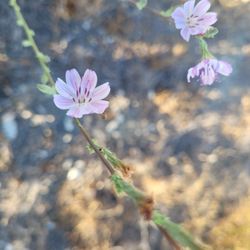
Cherry Canyon Park (which I am assuming was named after the native hollyleaf cherries that grow in the canyon) offers beautiful views and a great workout. The park preserves over 130 acres of green space near the city of La Canada and is accessible to all. Beautiful stands of oak and sycamore make the canyon a lovely place to hike all year long. Trails are well-marked and maintained. The trailhead parking lot only has enough space for three small cars; street parking is also available. Regarding the hollyleaf cherries, the fruit was reportedly fermented by the first residents of the US into an intoxicating drink. Cherry wine, anyone? Admission and parking are free.

I go mountain bike riding here maybe once a month. It is an insane cardio workout, without the treachery and dangers of actually being in the mountains/wilderness. They do have some technical parts as well, but I really just come for a great heart pump. Beware because I've seen a few snakes and I've heard of some mountain lions in the area, but it's usually very populated, so if you go during peak hours, I think you should be fine

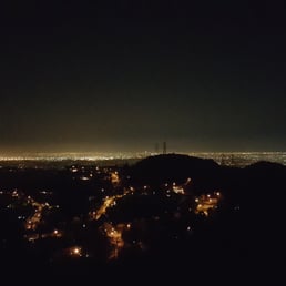
Yes you can see the ocean on a clear day! http://www.yelp.com/biz_photos/cherry-canyon-park-la-ca%C3%B1ada-flintridge?userid=o8Lo2pvM19nyYPBBycgSVg#M9fsVUAGwl7SJJNP9M9oZg It's cold and windy and that's the best time to get your hind end in gear and get up here to hike. Directions for newcomers: Exit Angeles Crest Hwy from 210 - Eastbound turn right at light and westbound turn left at light. Go down to Foothill Blvd. and turn right. Turn left on Chevy Chase Canyon and go about .75 miles to Hampstead Rd. and turn right. The entrance is about .9 miles up the street on the right. Walk up to the sign and head left on the Owl Trail. If you are a beginner just take the fire road on the right. In twenty minutes you'll be close to the top to soak up the gorgeous view. It's a new year so get out there and get moving!


This place is truly a hidden gem and is not what you'd expect. The park I tucked away in the seedy, run down area of La Canada. I mean some of the houses in the area are barely over a million dollars. Who would want to live near this park? The parking, as previously stated in previous reviews, is limited. And by limited, there is no parking lot for the park. You have to park on a nearby street. The residents of La Canada are smart people. If you don't provide sidewalks or curbs in front of your house, rif raf like me and my lady friend can't stop in front of your giant house. I see what you did there. We found a somewhat decent spot near the park entrance. Pretty sure it was parking ticket worthy, but we did not see that sweet little piece of paper tucked lovingly under our window upon return to the car. The hiking was good. The trail head markers offer up many hard to follow trails. I would like to say we took the Cerro Negro trail loop, but we did not loop. We ended up taking a side trail and walking through the dangerous side streets that took us back to our car. There are many forks to the trail that allow you to explore many parts of the area. There is some mild elevation climb, but it's good for leisurely hikers, kids, and animals. We were crunched for time so we only did 2 miles in about 40 minutes. Fun place to hike. Just be careful in the neighborhoods. Gangster.
")
If you're having trouble finding the entrance type the address 4171 Hampstead Road in instead of the one given here on Yelp. You can't park there but that's where the trails start. It looks like there's plenty of parking space but it's full of 'No Parking' signs and a big fire lane. The chances of a Parking Enforcement officer being up there is probably pretty slim but all it takes is one angry neighbor calling. We found street parking close by and walked. We took the Owl Trail. If you take this route I recommend going straight (right) when you get to the first split. It's much, much easier to walk on. It doesn't take long before you reach a peak with some decent views (around 1/2 a mile up). From there we went up just a little more to the highest peak where there are some satellites and generators. We also found a nice little memorial up there for someone. On the backside of the generators is a great place to sit and hangout, there are a few trees for shade and a constant breeze. To head down the mountain we took the Ultimate Destination Trail which eventually connected us back with the Owl Trail (how I know the other route up was better). Overall it's a nice area if you're looking for a quick hike without driving up the mountains. Our trip was 2.12 miles in 1 hour 12 minutes with an elevation gain of 489 feet.

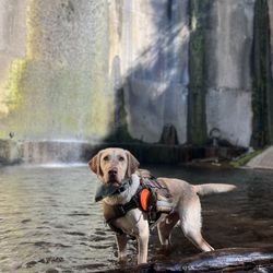
Took a nice afternoon hike here over the weekend and was pleasantly surprised. Cherry Canyon is a hidden park in the La Canada Mountains; somewhat near Descanso Gardens. Personally, I found it hard to locate the park because it is surrounded by numerous houses and didn't quite stick out much. We entered the park on Chevy Chase and Hamstead Rd. as suggested by a fellow yelper. Parking There isn't much parking offered by the park but you can snag street parking if you look out for the right signs. We opted for parking right in front of a house that was just outside of the "No Parking" zone; not far at all. Trail The park offers up a few trails such as the Owl Trail, Cerro Negro Trail, and the Cherry Canyon Fire/Utility Road. The Owl Trail and the Cerro Negro Trail are pretty much intertwined together; the Owl Trail is the only trail that has a steep incline that can be difficult depending on you're hiking ability. We didn't make an effort to take the Cherry Canyon Fire/Utility Road because it didn't seems as appealing as the other trails however it does connect to the other trails down the line. The Crowd There wasn't too many hikers here which is a nice change compared to other local trails. I did notice that some people did bring their horses and dogs but that wasn't an issue because they looked after them. Overall Decent views of the city. Calm and relaxing with minimal distractions when it comes to others. Decently kept trails of different levels for all types of hikers. Parking can be tough.


The scenery here is truly gorgeous despite the very visible power lines.There are several different trails you can take and they vary in intensity. Another plus is that it never seems to get too crowded.There is also plenty of parking available since it's located in a residential area. Overall it's a lovely place to visit if you're looking for some peace, quiet time and beauty.

Nice hiking trail near Glendale area. I began the hike by starting at the brown gates. I've only been here once and hiked only one trail but did notice that there are many other trails to choose from once you reach the middle of the trail. Overall a nice, easy-moderate hike. Shaded when you begin the trail but no shade as you continue the trail. My personal preference are other trails one which either have more of a nature feel to them or with higher elevation gain. Parking is street parking - there was plenty when I arrived which was at 8 am.
4 months ago
You can park for free on the street which has many trees for shade. The hike entrance is to the right of the Descanso Gardens. If it's a hot day I recommend bringing some water and a hat. It's a two mile journey up to the top at Cerro Negro. We started our hike late around noon and it was hot with few people along the route. read more

6 months ago
Today is wild and it's yours. What can I say I'm wild for her cherry adventure. ;D Cherry Canyon Park composed of a small but dense network of trails that are great for hikers, runners, bikers and walkers. It offers a panoramic view of mountains. This park is located in La Cañada Flintridge near the popular Descanso Gardens. There are different entrance/exit points to CCP such as Descanso-CherryCanyon trail, Conservancy trail, Motorway, Forest hill and Hampstead. I decided to take the Descanso Cherry Canyon trail on Descanso dr road. The trail has an elevation gain of 950 ft with a hiking level of 4 (moderate with steep inclines; not for beginners). The loop trail length up to 5 miles and you'll definitely spend at least 2 hours; it's highest summit reach to 1,887 feet. Cherry Canyon trail is dog friendly and bike friendly. There is little to no shade on these trails. Fellow hikers were amiable and respectful. There's very little to no human traffic on these trails. Furthermore, the trails were well maintained and trail signs are abundant. However, you can easily get loss given these trails were interconnected as evidence by a young male hiker who got loss asked me for direction. Finding street parking was easy. Cell reception was good. Overall, it's a wonderful trail to get a good cardio workout and enjoy the mountain view. read more


Cherry Canyon Park (which I am assuming was named after the native hollyleaf cherries that grow in the canyon) offers beautiful views and a great workout. The park preserves over 130 acres of green space near the city of La Canada and is accessible to all. Beautiful stands of oak and sycamore make the canyon a lovely place to hike all year long. Trails are well-marked and maintained. The trailhead parking lot only has enough space for three small cars; street parking is also available. Regarding the hollyleaf cherries, the fruit was reportedly fermented by the first residents of the US into an intoxicating drink. Cherry wine, anyone? Admission and parking are free. read more


I go mountain bike riding here maybe once a month. It is an insane cardio workout, without the treachery and dangers of actually being in the mountains/wilderness. They do have some technical parts as well, but I really just come for a great heart pump. Beware because I've seen a few snakes and I've heard of some mountain lions in the area, but it's usually very populated, so if you go during peak hours, I think you should be fine read more

Yes you can see the ocean on a clear day! http://www.yelp.com/biz_photos/cherry-canyon-park-la-ca%C3%B1ada-flintridge?userid=o8Lo2pvM19nyYPBBycgSVg#M9fsVUAGwl7SJJNP9M9oZg It's cold and windy and that's the best time to get your hind end in gear and get up here to hike. Directions for newcomers: Exit Angeles Crest Hwy from 210 - Eastbound turn right at light and westbound turn left at light. Go down to Foothill Blvd. and turn right. Turn left on Chevy Chase Canyon and go about .75 miles to Hampstead Rd. and turn right. The entrance is about .9 miles up the street on the right. Walk up to the sign and head left on the Owl Trail. If you are a beginner just take the fire road on the right. In twenty minutes you'll be close to the top to soak up the gorgeous view. It's a new year so get out there and get moving! read more


5 years ago
This was a beautiful place to hike however the trails were very confusing to navigate. This park has many trails and you can get easily lost. We did the Forest Hill Road and Cherry Canyon Motorway trails, and we went in a loop. So it was fun, short, and quite an adventure. read more


This place is truly a hidden gem and is not what you'd expect. The park I tucked away in the seedy, run down area of La Canada. I mean some of the houses in the area are barely over a million dollars. Who would want to live near this park? The parking, as previously stated in previous reviews, is limited. And by limited, there is no parking lot for the park. You have to park on a nearby street. The residents of La Canada are smart people. If you don't provide sidewalks or curbs in front of your house, rif raf like me and my lady friend can't stop in front of your giant house. I see what you did there. We found a somewhat decent spot near the park entrance. Pretty sure it was parking ticket worthy, but we did not see that sweet little piece of paper tucked lovingly under our window upon return to the car. The hiking was good. The trail head markers offer up many hard to follow trails. I would like to say we took the Cerro Negro trail loop, but we did not loop. We ended up taking a side trail and walking through the dangerous side streets that took us back to our car. There are many forks to the trail that allow you to explore many parts of the area. There is some mild elevation climb, but it's good for leisurely hikers, kids, and animals. We were crunched for time so we only did 2 miles in about 40 minutes. Fun place to hike. Just be careful in the neighborhoods. Gangster. read more


11 years ago
If you're having trouble finding the entrance type the address 4171 Hampstead Road in instead of the one given here on Yelp. You can't park there but that's where the trails start. It looks like there's plenty of parking space but it's full of 'No Parking' signs and a big fire lane. The chances of a Parking Enforcement officer being up there is probably pretty slim but all it takes is one angry neighbor calling. We found street parking close by and walked. We took the Owl Trail. If you take this route I recommend going straight (right) when you get to the first split. It's much, much easier to walk on. It doesn't take long before you reach a peak with some decent views (around 1/2 a mile up). From there we went up just a little more to the highest peak where there are some satellites and generators. We also found a nice little memorial up there for someone. On the backside of the generators is a great place to sit and hangout, there are a few trees for shade and a constant breeze. To head down the mountain we took the Ultimate Destination Trail which eventually connected us back with the Owl Trail (how I know the other route up was better). Overall it's a nice area if you're looking for a quick hike without driving up the mountains. Our trip was 2.12 miles in 1 hour 12 minutes with an elevation gain of 489 feet. read more
 - Hiking Near Me - La Cañada Flintridge, California")


Took a nice afternoon hike here over the weekend and was pleasantly surprised. Cherry Canyon is a hidden park in the La Canada Mountains; somewhat near Descanso Gardens. Personally, I found it hard to locate the park because it is surrounded by numerous houses and didn't quite stick out much. We entered the park on Chevy Chase and Hamstead Rd. as suggested by a fellow yelper. Parking There isn't much parking offered by the park but you can snag street parking if you look out for the right signs. We opted for parking right in front of a house that was just outside of the "No Parking" zone; not far at all. Trail The park offers up a few trails such as the Owl Trail, Cerro Negro Trail, and the Cherry Canyon Fire/Utility Road. The Owl Trail and the Cerro Negro Trail are pretty much intertwined together; the Owl Trail is the only trail that has a steep incline that can be difficult depending on you're hiking ability. We didn't make an effort to take the Cherry Canyon Fire/Utility Road because it didn't seems as appealing as the other trails however it does connect to the other trails down the line. The Crowd There wasn't too many hikers here which is a nice change compared to other local trails. I did notice that some people did bring their horses and dogs but that wasn't an issue because they looked after them. Overall Decent views of the city. Calm and relaxing with minimal distractions when it comes to others. Decently kept trails of different levels for all types of hikers. Parking can be tough. read more


14 years ago
Found a couple of big-eared ladies without clothing, walking around the park. http://www.yelp.com/biz_photos/vOyG5S7bTdpIoABnVcwsTQ?select=REvzDvEwVAA65UNyA-8v5g#J5t4CMYepjInKfLGgyJ_Ng read more

12 years ago
This is, most definitely, a secret gem of Los Angeles. The Owl Trail is great, and the views from the top are majestic. I was pleasantly surprised by this. FYI, parking is greatly limited, BUT there were only two other people on the trail. Check this place out!!! # read more

7 years ago
10 years ago
10 years ago
The scenery here is truly gorgeous despite the very visible power lines.There are several different trails you can take and they vary in intensity. Another plus is that it never seems to get too crowded.There is also plenty of parking available since it's located in a residential area. Overall it's a lovely place to visit if you're looking for some peace, quiet time and beauty. read more


10 years ago
Nice hiking trail near Glendale area. I began the hike by starting at the brown gates. I've only been here once and hiked only one trail but did notice that there are many other trails to choose from once you reach the middle of the trail. Overall a nice, easy-moderate hike. Shaded when you begin the trail but no shade as you continue the trail. My personal preference are other trails one which either have more of a nature feel to them or with higher elevation gain. Parking is street parking - there was plenty when I arrived which was at 8 am. read more


8 years ago
10 years ago
I come here to escape the crazy LA environment. I love that it's a hidden spot and it's not filled with garbage and everything. read more


9 years ago
14 years ago
10 years ago
More info about Cherry Canyon Park
4157 Hampstead Rd
La Cañada Flintridge, CA 91011
Directions
Hours
Outdoor Amenities
Ask the Community - Cherry Canyon Park
Review Highlights - Cherry Canyon Park
You might also consider


Why does Yelp recommend reviews?
2 reviews that are not currently recommended
The reviews below are not factored into the business's overall star rating.
10 years ago
11 years ago
Cherry Canyon Park - hiking - Updated July 2026
Best of La Cañada Flintridge
People found Cherry Canyon Park by searching for…
Parks in La Cañada Flintridge, CA
Hiking Trails in La Cañada Flintridge, CA
Star Gazing in La Cañada Flintridge, CA
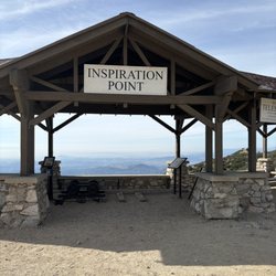
Scenic View in La Cañada Flintridge, CA
Meteor Shower in La Cañada Flintridge, CA
Lookout Points in La Cañada Flintridge, CA
Places to Watch Sunset in La Cañada Flintridge, CA
Secret Spots in La Cañada Flintridge, CA
Walking Trails in La Cañada Flintridge, CA
Easy Hikes in La Cañada Flintridge, CA
Beautiful Views in La Cañada Flintridge, CA
Scenic Drives in La Cañada Flintridge, CA
Scenic Overlook in La Cañada Flintridge, CA
Shaded Hike in La Cañada Flintridge, CA
Full Moon Hike in La Cañada Flintridge, CA
Hiking Trails Kid Friendly in La Cañada Flintridge, CA
Picnic Areas in La Cañada Flintridge, CA
Photo Spots in La Cañada Flintridge, CA
Views in La Cañada Flintridge, CA
Scenic Places to Walk in La Cañada Flintridge, CA
Running Trails in La Cañada Flintridge, CA
Off Road Trails in La Cañada Flintridge, CA
Trending Searches in La Cañada Flintridge, CA
Blueberry Picking near Cherry Canyon Park
Cliff Jumping near Cherry Canyon Park
Day Trips near Cherry Canyon Park
Dog Friendly Beaches near Cherry Canyon Park
Jet Ski Rental near Cherry Canyon Park
Kayak Rental near Cherry Canyon Park
Lakes & Ponds near Cherry Canyon Park
Off Road Trails near Cherry Canyon Park
Outdoor Activities near Cherry Canyon Park
Peach Picking near Cherry Canyon Park
Places To Swim near Cherry Canyon Park
Places To Walk Around near Cherry Canyon Park
Pokemon Go near Cherry Canyon Park
Pool Day Pass near Cherry Canyon Park
Public Shower near Cherry Canyon Park
River Swimming near Cherry Canyon Park
River Tubing near Cherry Canyon Park
Rock Quarry near Cherry Canyon Park
Scenic Night View near Cherry Canyon Park
Scenic Overlook near Cherry Canyon Park
Secluded Spots near Cherry Canyon Park
Soccer Store near Cherry Canyon Park
Sunrise View near Cherry Canyon Park
Swimming Holes near Cherry Canyon Park
Swimming Lakes near Cherry Canyon Park
U Pick Farms near Cherry Canyon Park
Browse Articles
Browse Nearby
BEST of La Cañada Flintridge, California Coffee near Cherry Canyon Park
BEST of La Cañada Flintridge, California Things to Do near Cherry Canyon Park
BEST of La Cañada Flintridge, California Restaurants near Cherry Canyon Park
BEST of La Cañada Flintridge, California Walking Trails near Cherry Canyon Park
BEST of La Cañada Flintridge, California Parks near Cherry Canyon Park
BEST of La Cañada Flintridge, California Breakfast near Cherry Canyon Park
BEST of La Cañada Flintridge, California Campgrounds near Cherry Canyon Park
BEST of La Cañada Flintridge, California Day Trips near Cherry Canyon Park
BEST of La Cañada Flintridge, California Sledding near Cherry Canyon Park
Browse Brands
Related Searches in La Cañada Flintridge, CA
Best Dog Hiking Trails Around La Cañada Flintridge, California
Best Fishing Locations and Guides in La Cañada Flintridge, California
Best Nature Trails for Hiking in La Cañada Flintridge, California
Best Places for Horseback Riding in La Cañada Flintridge, California
Check Out Off Road Trails in La Cañada Flintridge, California
Discover Dog Friendly Trails to Explore in La Cañada Flintridge, California
Discover Easy Hiking Trails Near La Cañada Flintridge, California
Discover Kid Friendly Hiking Trails in La Cañada Flintridge, California
Discover Popular Bike Trails in La Cañada Flintridge, California
Discover Scenic Mountain Bike Trails Near La Cañada Flintridge, California
Discover Walking Parks in La Cañada Flintridge, California Near You
Discover a Hiking Trail in La Cañada Flintridge, California
Discover the Best Night Hike Trails in La Cañada Flintridge, California
Dog-Friendly Hikes With Dogs in La Cañada Flintridge, California
Enjoy Camping Adventures Around La Cañada Flintridge, California
Enjoy Kayaking Adventures in La Cañada Flintridge, California
Enjoy Off Leash Dog Hikes in La Cañada Flintridge, California
Enjoy Scenic Places to Walk in La Cañada Flintridge, California
Enjoy a Beautiful Waterfall Hike in La Cañada Flintridge, California
Enjoy the Best Walking Path in La Cañada Flintridge, California
Enjoy the Best Walking Trails in La Cañada Flintridge, California
Explore Beautiful Parks and Green Spaces in La Cañada Flintridge, California
Explore Easy Hikes Perfect for All in La Cañada Flintridge, California
Explore Fun Activities to Do in La Cañada Flintridge, California
Explore Popular Campgrounds Near La Cañada Flintridge, California
Explore Popular Dog Walking Trails in La Cañada Flintridge, California
Explore Top Dog Parks in La Cañada Flintridge, California Near You
Explore the Best Beach Spots in La Cañada Flintridge, California
Family Friendly Hiking With Kids in La Cañada Flintridge, California
Find Beautiful Views in La Cañada Flintridge, California
Find Parks and Recreation Activities in La Cañada Flintridge, California
Find Top Dog Friendly Parks to Visit in La Cañada Flintridge, California
Find Top-Rated Waterfalls in La Cañada Flintridge, California Now
Find the Best Parks for Picnics in La Cañada Flintridge, California
Hiking Trails With Waterfalls in La Cañada Flintridge, California
Off Leash Dog Hiking Trails in La Cañada Flintridge, California
Popular Outdoor Activities to Try in La Cañada Flintridge, California
Popular Picnic Spots to Visit in La Cañada Flintridge, California
Popular Waterfall Hiking Trails in La Cañada Flintridge, California
Safe River Swimming Areas in La Cañada Flintridge, California
Safe and Fun Parks for Kids in La Cañada Flintridge, California
Top Hiking Trails to Explore in La Cañada Flintridge, California
Top Playgrounds for Kids to Enjoy in La Cañada Flintridge, California
Top Running Trails to Explore in La Cañada Flintridge, California
Top Swimming Lakes to Enjoy in La Cañada Flintridge, California
Top Swimming Spots and Pools in La Cañada Flintridge, California
Top-Rated Camping Sites in La Cañada Flintridge, California
Walk Dog Friendly Hiking Trails in La Cañada Flintridge, California
Walk the Best Paved Walking Trails in La Cañada Flintridge, California