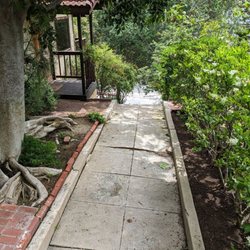
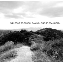
Leviathan's Teeth Trail Photos


You might also consider
More like Leviathan's Teeth Trail
Recommended Reviews - Leviathan's Teeth Trail
Start your review...

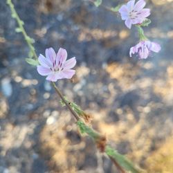
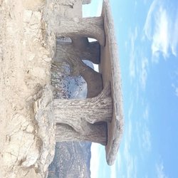
This trail (and by the way I have no idea how it got its name) is hidden in the hills above Glendale and La Crescenta. It's one of my favorite hikes in the area because it's pretty strenuous, yet it's all uphill out and downhill back (my favorite kind of hike). I love it because you got some pretty awesome views after just a few minutes of hiking. In fact I think this trail has some of the best views of the Crescenta Valley in the area. The Yelp directions are really accurate but parking is limited as it's in a residential area. I was lucky enough to hike on a weekday and have no idea what it would be like on a weekend; I found parking easily and didn't see another soul, other than a gazillion lizards. Be safe, take a cell phone and any other safety gear that's needed. And don't forget water. read more


More info about Leviathan's Teeth Trail
Engelhard Canyon Edison Rd
Glendale, CA 91208
Directions
Hours
Outdoor Amenities
You might also consider


Leviathan's Teeth Trail - hiking - Updated June 2026
Best of Glendale
People found Leviathan's Teeth Trail by searching for…
Hiking Trails in Glendale, California
Scenic View in Glendale, California
Fun Things to Do in Glendale, California
Secret Spots in Glendale, California
Walking Trails in Glendale, California
Bike Paths in Glendale, California
Shaded Hike in Glendale, California
Free Things to Do in Glendale, California
Empty Parking Lot in Glendale, California
Running Trails in Glendale, California
Fun Places to Go in Glendale, California
Walking Path in Glendale, California
Fall Foliage in Glendale, California
Secluded Spots in Glendale, California
Off Leash Dog Hikes in Glendale, California
Things to Do at Night in Glendale, California
Waterfall in Glendale, California
Places to Walk at Night in Glendale, California
Easy Hikes in Glendale, California
Hiking Trails Kid Friendly in Glendale, California
Lookout Points in Glendale, California
Trending Searches in Glendale, CA
Black Owned Nail Salons near Leviathan's Teeth Trail
Boat Rental near Leviathan's Teeth Trail
Cliff Jumping near Leviathan's Teeth Trail
Day Trips near Leviathan's Teeth Trail
Dog Friendly Trails near Leviathan's Teeth Trail
Fishing Spots near Leviathan's Teeth Trail
Jet Ski Rental near Leviathan's Teeth Trail
Kayak Rental near Leviathan's Teeth Trail
Lakes & Ponds near Leviathan's Teeth Trail
Off Road Trails near Leviathan's Teeth Trail
Outdoor Activities near Leviathan's Teeth Trail
Places To Walk Around near Leviathan's Teeth Trail
Public Pools near Leviathan's Teeth Trail
Public Shower near Leviathan's Teeth Trail
River Swimming near Leviathan's Teeth Trail
Rock Quarry near Leviathan's Teeth Trail
Scenic Night View near Leviathan's Teeth Trail
Scenic Overlook near Leviathan's Teeth Trail
Secluded Spots near Leviathan's Teeth Trail
Soccer Store near Leviathan's Teeth Trail
Splash Pad near Leviathan's Teeth Trail
Strawberry Picking near Leviathan's Teeth Trail
Sunrise View near Leviathan's Teeth Trail
Swimming Holes near Leviathan's Teeth Trail
Swimming Lakes near Leviathan's Teeth Trail
U Pick Farms near Leviathan's Teeth Trail
Watch Sunset near Leviathan's Teeth Trail
Browse Articles
Browse Nearby
BEST of Glendale, California Coffee near Leviathan's Teeth Trail
BEST of Glendale, California Restaurants near Leviathan's Teeth Trail
BEST of Glendale, California Things to Do near Leviathan's Teeth Trail
BEST of Glendale, California Walking Trails near Leviathan's Teeth Trail
BEST of Glendale, California Parks near Leviathan's Teeth Trail
BEST of Glendale, California Breakfast near Leviathan's Teeth Trail
BEST of Glendale, California Caves near Leviathan's Teeth Trail
BEST of Glendale, California Hot Springs near Leviathan's Teeth Trail
BEST of Glendale, California Campgrounds near Leviathan's Teeth Trail
Browse Brands
Related Searches in Glendale, CA
Affordable Kayak Rental Services in Glendale, California
Best Fishing Locations and Guides in Glendale, California
Best Nature Trails for Hiking in Glendale, California
Best Places for Horseback Riding in Glendale, California
Check Out Off Road Trails in Glendale, California
Discover Dog Friendly Trails to Explore in Glendale, California
Discover Kid Friendly Hiking Trails in Glendale, California
Discover Scenic Hiking Trails in Glendale, California
Discover Scenic Mountain Bike Trails Near Glendale, California
Discover Scenic Waterfall Spots in Glendale, California
Discover Walking Parks in Glendale, California Near You
Discover a Hiking Trail in Glendale, California
Discover the Best Night Hike Trails in Glendale, California
Discover the Best Running Track in Glendale, California
Dog-Friendly Hikes With Dogs in Glendale, California
Enjoy Camping Adventures Around Glendale, California
Enjoy Exciting Mountain Biking Adventures in Glendale, California
Enjoy Kayaking Adventures in Glendale, California
Enjoy Tent Camping Spots Around Glendale, California
Enjoy a Beautiful Waterfall Hike in Glendale, California
Enjoy a Peaceful Nature Walk in Glendale, California
Enjoy the Best Walking Path in Glendale, California
Enjoy the Best Walking Trails in Glendale, California
Exciting Cliff Jumping Spots in Glendale, California
Explore Beautiful Parks and Green Spaces in Glendale, California
Explore Easy Hikes Perfect for All in Glendale, California
Explore Fun Activities to Do in Glendale, California
Explore Popular Campgrounds Near Glendale, California
Explore the Best Beach Spots in Glendale, California
Explore the Best Trail Options in Glendale, California
Family Friendly Hiking With Kids in Glendale, California
Find Beautiful Views in Glendale, California
Find the Best Parks for Picnics in Glendale, California
Find the Best Scenic View Locations in Glendale, California
Great Places to Walk in Glendale, California
Hike the Popular Waterfall Trail in Glendale, California
Hiking Trails With Waterfalls in Glendale, California
Off Leash Dog Hiking Trails in Glendale, California
Plan a Scenic Drive Route Near Glendale, California
Popular Outdoor Activities to Try in Glendale, California
Popular Picnic Spots to Visit in Glendale, California
Safe River Swimming Areas in Glendale, California
Safe and Fun Parks for Kids in Glendale, California
Top Climbing Spots and Gyms in Glendale, California
Top Paddleboarding Activities in Glendale, California
Top Running Trails to Explore in Glendale, California
Top Swimming Lakes to Enjoy in Glendale, California
Top Swimming Spots and Pools in Glendale, California