Brand Park Photos


You might also consider
More like Brand Park
Recommended Reviews - Brand Park
Start your review...

Reviews With Photos

 Happy new year 2023")
100% peaceful. I use to come here as a kid with my Grandma. As I got older I can really appreciate my alone time here. I've come here so many times within the past few years. I've come here just to take a break from the world. Ive gone on a hike here and loved it. Today on the first of January 2023 I sat in the car watching Dracula Untold on Netflix as it started to sprinkle. I saw others sitting in their car too relaxing. I hope everyone brought snacks like i did. Peanut butter & jelly on Jewish rye bread. A bottle of water and espresso beans with grapes.

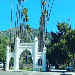
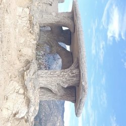
Brand Park is a wonderful facility located on the border of Burbank/Glendale at the foot of the Verdugo Mountains. It has a ton of facilities with the Brand Library being the center piece. There are picnic areas, baseball diamonds, some historical architecture and just lots of green space. You can also access the trail head for several trails that takes you up to the peak of the Verdugo Mountains. On this afternoon I decided to give the "Seven Trees Trail" or on AllTrails, it's listed as the "Brand Park Lateral Loop" a try. I just purchased a new pair of hiking shoes and thought this would be a good opportunity to put it to the test. The Seven Trees Trail head is located on the right hand side of the parking lot, right behind the library building. From there you head up the trail which initially is manageable with a steady incline about 15% grade, but definitely doable. (Note, I would not do this trail without hiking shoes or a pair of good trail runners). After about half a mile up or at least it felt like half a mile up for me you start hitting some of the steeper section of the incline. Hiking sticks are useful here, especially if you're not sure footed. It is doable, even if you're not in the greatest shape. Just take your time and make sure you rest. If you do, do the loop, you definitely want to go this way, the counterclockwise direction as I would not recommend descending down this part of the trail. After about a mile, you get to the flat section where there are benches and signs showing the history of Glendale and the El Rancho area. From here, you have the option of continuing up the trail which eventually will take you to the Tongva Peak or head left and start descending down the trail. If you're not an experience hiker or don't have the proper equipment, I would take the descend here. I went up half way and decided to turn around as it was getting steeper and I was quite exposed. Heading down the trail, you come up on a small waterfall and a stream. From here it's all descends and pretty manageable. You eventually connect up with the Brand Motorway Trail and that's mostly a paved fire road, but still watch your footing as there are numerous potholes and the descend is still somewhat steep. Eventually you'll come out next to the victorian house on the opposite side of the parking lot where did your initial ascend. Overall, it's a good workout. It's only a little over 2 miles roundtrip, but definitely felt longer and as the summer approaches, you'll want to consider hydration, sunblock and a hat as it could get pretty brutal on trail.
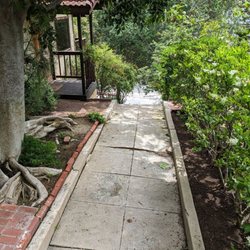
The park is really stunning! You can play soccer, baseball, there is playground, library, art exhibit, a Japanese house, and a museum. I was for the Blossom Cherry Celebration, it was nice, but it disappointed me because there isn't Cherry trees. They could be more honest when publicized the event. However, I met another beautiful park. The neighborhood is great and close to there is a street with many restaurants.

Fun hiking trail! There are three paths, and I took the Miss American Green Cross Trail. When I was there, the Brand Motorway Trail was blocked off, so I couldn't take that one. As I kept walking, it felt like the trail was getting steeper and steeper. I got tired not even halfway through! Thankfully, there are a few stops along the way, where we can sit and rest. Plus there are arrows for guidance if you feel lost. Highly recommend to wear hiking shoes because there are some slippery slopes and rocks out there. It was a hot and sunny day when I went, yet still a very enjoyable adventure. Nice view of the city from all the way at the top. I would say that this hiking trail takes a minimum of one hour to get through, probably longer if you take your time. Had a good workout from this. Water is essential!

Lovely park with various trails to explore. Recommend wearing hiking boots or hiking type sneakers. Some steep and rocky inclines. Great work out. Awesome views. Free parking lot. So much to enjoy at park besides trails to hike on. There's a playground for the kids, the gorgeous Brand library, enjoy a picnic, there's a Japanese tea house and more!


Beautiful up here and all the rains lately have it looking so plush and green. There are tons of paths and they seem pretty safe. Most I believe are a little steep and most are rugged. There may be one that is on pavement. I'm not sure. This is my second time here and it has been during the week so not too many people here. Nice and quite with beautiful views

My wife and I love Brand Park and the long history behind the property , we just recently started hiking the trails and found it to be nice with views in all directions as far as the eye can see . The 7 trees trail is not for little kids or those in not in some kind of shape as the climb to the top is pretty much straight up . We highly recommend the this hike but keep in mind it's not for the faint at heart and those in poor conditioning !

Brand Park has tons to offer & explore: Library, Japanese Tea House & Garden, playground, basketball, baseball, etc. The entrance & drive in and out is eye candy in itself. But, this review centers on the *SEVEN TREES TRAIL". It's a very steep incline the entire way. The trail plateaus briefly half way up with benches and plaques to read about Glendale's history. You can stop there or continue upward. This 2nd half of the incline is rough, extremely Steep. And what goes up must come down. Tread cautiously. Wear shoes with good traction especially recommended for your decent which is not easy on the knees. This is an exposed trail. The only shade you'll get is at the very beginning and it's short lived. Early morning or sunset hiking is best. Great over view of multiple cities spanning from Pasadena to Studio City. Take a breather at the top, look around for all the things/places you can spot :)

Great trail if you want a good work out! It is pretty steep from the beginning so you ended up climbing up fast. The trail is very narrow and has a lot of loose rocks so you do have to wear good shoes especially when you are coming down (My doggy didn't enjoy this). It has really great views of Burbank, DTLA, Griffith Park and the Valley. I wanted to complete the loop of all trails but my dog wasn't having it he was exhausted. Lots of Parking plus you have the library, doctor's house, park and the beautiful tea house to scope out after. Might just have to leave my hiking buddy next time.

This is a nice place to hike but it can be very challenging. You can park on the left side of the lot which is near the library. The right side is the playground area which you can still park, but it's a bit of a walk to the library. There are restroom in the area and parking is free. That I know of, there are three trails from this area. 1. Brand Motorway (check out runtheverdugos.com) 2. Miss America Green Cross Trail (Statue) 3. Seven Tree Trail All of these you can hike in, then hike back out or you can do a nice big loop pending how much time you have. For me I started at Seven Tree Trail which is behind the Library. Further to the left is a statue for Miss America Green Cross trail. And way left you will see posted sign for Brand Motorway. The trail for seven tree was not bad in the beginning with a nice incline. As you near the flat section with benches, it gets a lot steeper if you're aiming for the radio towers. Definitely, you want to wear good hiking shoes and probably want to bring hiking sticks. The first radio tower is Mount Thom. You can head back the way you came up, or continue on to the next radio tower going towards Verdugo Motorway. Once you reach the second radio tower, this is Tongva Peak. You can continue on till you hit Brand Motorway, and then hike back down to make this a loop trail. But in front of the benches in Tongva Peak, there is a trail to take you back down to the library which I decided to try. It is very steep, even with hiking shoes and sticks, it was a bit of an adventure. On my fitbit, it stated around 4 miles round trip, but it can be longer if you want to do the Brand Motorway loop. This is definitely not for kids. You can get hurt if you don't watch your footing. As an alternative, Beaudry Loop or Las Flores Motorway is another hike that takes you to these radio towers. I would definitely come back and hike Brand Motorway and explore Miss America Green Cross trail as I did not start from that trail head. As always pack accordingly to the weather and have fun.

This is a nice place to take a hike and we did a short hike on Memorial Day for about an hour. I would recommend some good hiking shoes as some of terrain gets tricky, the last thing you want to do is twist your ankle. We were on a mission to find the Brand family cemetery located within a half mile of the library.

It's been years since I was last here, during Covid to be exact. It's when we all needed to be outside in the open air to clear our minds. Hiking was the spot here when I was visiting but this time it was just for a little wandering around. Still pretty as the last time I was here. Very open with a pretty big lot for cars. You have the baseball fields, and a good amount of picnic area. I didn't venture throughout as it was just a little stroll after brunch. We did pop into the teahouse area which was pretty. There's also a little Park area where you could lounge and relax. Believe you're allowed to bring food inside but not sure about grilling. They had yours being offered for the doctor's house which we didn't do. The teahouse, not sure how often tours go for that. We walked around and just enjoyed the outside of the facades, the koi pond and just being relaxed. There were plenty of people doing the same as it was a nice a sunny afternoon. read more


2 years ago
This review is for the Brand Library Trail hike. Go clockwise and wear shoes with good tread! The trail can be steep in some parts when ascending, which may be more of a challenge if you're just looking for a casual stroll. When going back down, it's steep and can be slippery. I was afraid of sliding down! There is also no shade, but at least there are good views of Glendale & LA. read more


2 years ago
Brand Park is a great place to hike. They have a library and a Dr.'s house/museum, a Japanese Tea house/garden and softball field. Beautiful views of the mountains and good parking. We like taking walks here. It's free! read more
4 years ago
100% peaceful. I use to come here as a kid with my Grandma. As I got older I can really appreciate my alone time here. I've come here so many times within the past few years. I've come here just to take a break from the world. Ive gone on a hike here and loved it. Today on the first of January 2023 I sat in the car watching Dracula Untold on Netflix as it started to sprinkle. I saw others sitting in their car too relaxing. I hope everyone brought snacks like i did. Peanut butter & jelly on Jewish rye bread. A bottle of water and espresso beans with grapes. read more
 Happy new year 2023 - Hiking Near Me - Glendale, California")


3 years ago
Brand Park is a wonderful facility located on the border of Burbank/Glendale at the foot of the Verdugo Mountains. It has a ton of facilities with the Brand Library being the center piece. There are picnic areas, baseball diamonds, some historical architecture and just lots of green space. You can also access the trail head for several trails that takes you up to the peak of the Verdugo Mountains. On this afternoon I decided to give the "Seven Trees Trail" or on AllTrails, it's listed as the "Brand Park Lateral Loop" a try. I just purchased a new pair of hiking shoes and thought this would be a good opportunity to put it to the test. The Seven Trees Trail head is located on the right hand side of the parking lot, right behind the library building. From there you head up the trail which initially is manageable with a steady incline about 15% grade, but definitely doable. (Note, I would not do this trail without hiking shoes or a pair of good trail runners). After about half a mile up or at least it felt like half a mile up for me you start hitting some of the steeper section of the incline. Hiking sticks are useful here, especially if you're not sure footed. It is doable, even if you're not in the greatest shape. Just take your time and make sure you rest. If you do, do the loop, you definitely want to go this way, the counterclockwise direction as I would not recommend descending down this part of the trail. After about a mile, you get to the flat section where there are benches and signs showing the history of Glendale and the El Rancho area. From here, you have the option of continuing up the trail which eventually will take you to the Tongva Peak or head left and start descending down the trail. If you're not an experience hiker or don't have the proper equipment, I would take the descend here. I went up half way and decided to turn around as it was getting steeper and I was quite exposed. Heading down the trail, you come up on a small waterfall and a stream. From here it's all descends and pretty manageable. You eventually connect up with the Brand Motorway Trail and that's mostly a paved fire road, but still watch your footing as there are numerous potholes and the descend is still somewhat steep. Eventually you'll come out next to the victorian house on the opposite side of the parking lot where did your initial ascend. Overall, it's a good workout. It's only a little over 2 miles roundtrip, but definitely felt longer and as the summer approaches, you'll want to consider hydration, sunblock and a hat as it could get pretty brutal on trail. read more


The park is really stunning! You can play soccer, baseball, there is playground, library, art exhibit, a Japanese house, and a museum. I was for the Blossom Cherry Celebration, it was nice, but it disappointed me because there isn't Cherry trees. They could be more honest when publicized the event. However, I met another beautiful park. The neighborhood is great and close to there is a street with many restaurants. read more


Fun hiking trail! There are three paths, and I took the Miss American Green Cross Trail. When I was there, the Brand Motorway Trail was blocked off, so I couldn't take that one. As I kept walking, it felt like the trail was getting steeper and steeper. I got tired not even halfway through! Thankfully, there are a few stops along the way, where we can sit and rest. Plus there are arrows for guidance if you feel lost. Highly recommend to wear hiking shoes because there are some slippery slopes and rocks out there. It was a hot and sunny day when I went, yet still a very enjoyable adventure. Nice view of the city from all the way at the top. I would say that this hiking trail takes a minimum of one hour to get through, probably longer if you take your time. Had a good workout from this. Water is essential! read more


Lovely park with various trails to explore. Recommend wearing hiking boots or hiking type sneakers. Some steep and rocky inclines. Great work out. Awesome views. Free parking lot. So much to enjoy at park besides trails to hike on. There's a playground for the kids, the gorgeous Brand library, enjoy a picnic, there's a Japanese tea house and more! read more

I'm a beginner hiker and I enjoyed this trail. Completed it with my pup in about an hour. Just wish I brought better traction shoes - it gets pretty steep at times. Great views. Not many other people on the trail either! read more


Beautiful up here and all the rains lately have it looking so plush and green. There are tons of paths and they seem pretty safe. Most I believe are a little steep and most are rugged. There may be one that is on pavement. I'm not sure. This is my second time here and it has been during the week so not too many people here. Nice and quite with beautiful views read more


2 years ago
4 years ago
My wife and I love Brand Park and the long history behind the property , we just recently started hiking the trails and found it to be nice with views in all directions as far as the eye can see . The 7 trees trail is not for little kids or those in not in some kind of shape as the climb to the top is pretty much straight up . We highly recommend the this hike but keep in mind it's not for the faint at heart and those in poor conditioning ! read more


Brand Park has tons to offer & explore: Library, Japanese Tea House & Garden, playground, basketball, baseball, etc. The entrance & drive in and out is eye candy in itself. But, this review centers on the *SEVEN TREES TRAIL". It's a very steep incline the entire way. The trail plateaus briefly half way up with benches and plaques to read about Glendale's history. You can stop there or continue upward. This 2nd half of the incline is rough, extremely Steep. And what goes up must come down. Tread cautiously. Wear shoes with good traction especially recommended for your decent which is not easy on the knees. This is an exposed trail. The only shade you'll get is at the very beginning and it's short lived. Early morning or sunset hiking is best. Great over view of multiple cities spanning from Pasadena to Studio City. Take a breather at the top, look around for all the things/places you can spot :) read more


Great trail if you want a good work out! It is pretty steep from the beginning so you ended up climbing up fast. The trail is very narrow and has a lot of loose rocks so you do have to wear good shoes especially when you are coming down (My doggy didn't enjoy this). It has really great views of Burbank, DTLA, Griffith Park and the Valley. I wanted to complete the loop of all trails but my dog wasn't having it he was exhausted. Lots of Parking plus you have the library, doctor's house, park and the beautiful tea house to scope out after. Might just have to leave my hiking buddy next time. read more


7 years ago
This is a nice place to hike but it can be very challenging. You can park on the left side of the lot which is near the library. The right side is the playground area which you can still park, but it's a bit of a walk to the library. There are restroom in the area and parking is free. That I know of, there are three trails from this area. 1. Brand Motorway (check out runtheverdugos.com) 2. Miss America Green Cross Trail (Statue) 3. Seven Tree Trail All of these you can hike in, then hike back out or you can do a nice big loop pending how much time you have. For me I started at Seven Tree Trail which is behind the Library. Further to the left is a statue for Miss America Green Cross trail. And way left you will see posted sign for Brand Motorway. The trail for seven tree was not bad in the beginning with a nice incline. As you near the flat section with benches, it gets a lot steeper if you're aiming for the radio towers. Definitely, you want to wear good hiking shoes and probably want to bring hiking sticks. The first radio tower is Mount Thom. You can head back the way you came up, or continue on to the next radio tower going towards Verdugo Motorway. Once you reach the second radio tower, this is Tongva Peak. You can continue on till you hit Brand Motorway, and then hike back down to make this a loop trail. But in front of the benches in Tongva Peak, there is a trail to take you back down to the library which I decided to try. It is very steep, even with hiking shoes and sticks, it was a bit of an adventure. On my fitbit, it stated around 4 miles round trip, but it can be longer if you want to do the Brand Motorway loop. This is definitely not for kids. You can get hurt if you don't watch your footing. As an alternative, Beaudry Loop or Las Flores Motorway is another hike that takes you to these radio towers. I would definitely come back and hike Brand Motorway and explore Miss America Green Cross trail as I did not start from that trail head. As always pack accordingly to the weather and have fun. read more


8 years ago
This is a nice place to take a hike and we did a short hike on Memorial Day for about an hour. I would recommend some good hiking shoes as some of terrain gets tricky, the last thing you want to do is twist your ankle. We were on a mission to find the Brand family cemetery located within a half mile of the library. read more

5 years ago
6 years ago
This is an epic trail with amazing city views. I ran up then down into Glendale College. The total distance was 11.3 miles. Loved it! read more


7 years ago
This was the most pleasant surprise of my weekend! Happened upon the trail, started it without knowing what I had gotten myself into. It was definitely a little aggressive and steep in places, but the views made it well worth it. read more


3 years ago
8 years ago
This hike is a great butt and leg workout! There's different trails depending on how challenged you want to be--(fire road by Japanese tea garden is the easiest with wide trails that incline and flatter sections for rest...there's one between the tea garden and library and one behind the library...the later 2 are steady inclines, the middle trail is more rocky and narrow and I find a bit more challenging, and the other trail is wider and more loose dirt so i find it more slippery when going downhill....). My legs are pretty tired afterwards but I love it! No shade so on a hot day, sunscreen, sunglasses, water and a cap is recommended. Gorgeous view of Pasadena, Glendale, and Burbank at the overlook. After the hike, the park is a great place to grab some shade under a tree and nap or picnic. read more


I've been coming to this hike for years and every time I barely make it. Be sure to wear proper hiking shoes as it's a very narrow and slippery trail. It's a relatively shorter hike and you can get up to 7 trees in 30-45 minutes with plenty of breaks but you still get a great workout. There are a lot of new trails that I discover until today and there are a lot of attractions in the park (The library, 7 trees, cemetery, the koi pond, doctor's house, and many more) What I don't particularly like about the hike is the lack of shade. If you go up from the statue or the trail behind the library, you literally get no shade the whole way up. This is why I like to go early in the morning before the sun comes. Be sure to take plenty of water as the sun can seriously get to you. Also, be careful not to touch any poison ivy. read more

4 years ago
10 years ago
If you've read my review for Skyline trail, you can skip to the third paragraph, after the stats section. NOTE: stats reflect this hike at Brand Park. Continuing the Conditioning Hike Series of reviews. Several months ago, me and The Crew were headed to the backcountry on a strenuous backpacking trip. To prepare, I wanted to do some conditioning hikes to decrease my chances of having to be airlifted out. This was one of the trails I did several times prior to the trip. Back when I was a wee hiker, The Crew planned a shuttle hike. What the heck is a shuttle hike?!?!?! STATS: Distance: about 5 miles Elevation Gain: about 2100 ft. Time: 2-3 hours Rating: Strenuous Trail: Fire Road, Non-maintained Fire Road and Single Track w/very little shade. Trek; Car Shuttle, can be an up and back Just northeast of Griffith Park lie the Verdugo Mountains. Like Griffith Park, there are a freakton of trails, some are maintained and well-traveled, some are not. Like the trails at Griffith Park, the trails in the Verdugo's are not all that shaded, and it gets super hot haulin yourself up an ascent to capture a 180+ view of the city below, not to mention, watch as planes arrive and depart Bob Hope Airport, as the sun sets. If the air is clear enough, you can see the sun dipping itself into the ocean as its glow illuminates on the water. Fast forward years of hiking with The Crew, I learned quickly and almost the hard way what a shuttle hike entailed. I also learned that I'm not the only one who goes through this growing pain. Anywhoo, while hikes are up and back, or in and out, or point A to point A, where the starting and ending points are the same, a shuttle hike is a one-way hike and takes a more planning and organizing than a one-way hike. Everyone meets with their cars at the ending point, hikers pile into as few cars as possible, and carpool to the starting point/trailhead. The route mapped out should lead hikers back to the initial meeting point and drive those whose cars parked at the trailhead are carpooled back. Most often, The Crew does shuttle, or loop likes, one-way is typically on backpacking trips. Those looking for a strenuous conditioning hike, this one's for you. Trailhead is located at the top of the parking lot behind the cross. Unlike the Skyline Trail, which is a continuous steady incline, Brand Park is about two miles with about 2000 ft elevation gain. Yep, almost straight up. Heck sometimes I felt as if I was inverted. It is definitely NOT for beginners. The track is overgrown and a bit challenging in a few spots, but rewards hikers with some outstanding scenes of the Burbank and Glendale areas, and a nice steady incline, great for conditioning. The trail back down to our cars is the rutted firebreak that connects Beaudry to the library and can be a bit dangerous, but there are other, safer trails that lead back to the Brand Park, should you choose to do a car shuttle. Otherwise, y'all can return the same way you came, and make it a one-way hike. DISCLAIMER: Hiking is not something that can be taken lightly. It can be life-threatening as you see and hear on the news, people die or get lost all time. Please, if you are going to hike, never go alone and prepare for the worst, hope for the best. Remember when going for a hike, no matter how short you think it may be, always be prepared. Carry at least two liters of water for every five miles (more if the weather is warm), protein bar, nuts, and electrolytes. Wear sturdy lug sole shoes and protective clothing. Some areas the weather can change quicker than a firefighter can put on his gear. It is also very important, always always always let a family member or friend know where you are going and when you expect to be back. Lastly, have fun when you hike it up. read more


Having lived in Armenia (Glendale) for 9 years when I was younger, I can't believe I never hiked the trails at Brand Park before. I thought it was going to be some crazy difficult hike because of some of the reviews, but it turned out to be a letdown because I expected something longer than super short hike that only logged in at just under 2 miles... My friend and I just followed an Armenian couple who guided us to the top where the maps are and followed them down from there but now I'm thinking we were supposed to go further up towards the radio towers? Not sure... I mean we did see other trails but we didn't want to go on them without knowing where we'd end up. But I got the gist of this hike, which is a steep climb up with zero shade. It kinda reminded me of the Garcia Trail in Azusa, but unlike many hikes going up the mountain, this hike does not really involve switchbacks. The trail has many areas of loose gravel, so you have to be very careful especially on the way down. The views are okay, I guess. The main attraction is the view of the skyscrapers of DTLA and I also noticed Hollywood Hills Forest Lawn and Burbank Airport, nothing really special. read more


14 years ago
This hike is a SOB! It's an amazing workout because the incline is like 90 degrees at some points! Start at the back of the lot where there's a statue of a lady and a green cross. It starts fairly easy for about 5 mins then turns into a rigorous uphill climb. Damnnn! It's so hard but so rewarding cuz you're sweating like crazy but you know you can eat a whole plate of pasta afterward! My BF and I usually go up to the top of the towers (maybe 1hr 45 mins) and the 2nd portion up to the towers after you reach a flat resting area is the real bitch! It's gravel and dirt so it's easy to slip, you see all kinds of people doing it though. Old, young, groups, bicyclists (yes, bicyclists, OMG I can't even imagine going down that hill on a frickin' bicycle!). I would recommend starting early in the morning cuz the trail gets real hot (no shade/trees). There's a lot of people on the trail so no worries of getting lost. It's rewarding getting to the top, you get to see Glendale, Burbank, etc and the air is just fresh! read more

12 years ago
The hiking trails are located near the library. There are many options for trails going up and back down. If you take one directly behind the statue, it will be very steep! If you want a good workout without too much punishment - when you see the statue in the parking lot, look left in the distance and you will see a road. Take this road which will lead you across a dry reservoir, right at the cemetery sign, and it eventually becomes a small trail into the mountains. If you hike up to the the radio tower, it does get pretty steep and more difficult. parking - big free lot read more


13 years ago
I approached this trail the wrong way. I was itching to go hiking again, and my last hike was a little less than a year ago in Griffith Park. In other words, I was out of shape to even try to go up this trail. I found it on Yelp, read the good reviews and saw how close it was from my place. I went with a friend and was humbled by how tough some of the trails here were. I was huffing, puffing and sweating when we got halfway through the first mountain. Something I haven't done in a long time, but once we started ascending even higher up the trail, I saw how beautiful the view was, and felt how strong and cool the breeze was. This place got me into hiking again. I come here whenever I can, and it always is a good time for me when I am there. Not that many people and not too crowded. For beginners, there's a wide dirt road that starts at the Doctor's House and ascends up the mountain slowly. For the intermediate hiker, go to the trail where the green cross statue is. And for those who want to go straight vertical, Go through the trail that starts across the children's park. Only problem is the mess of scattered Swisher wrappers and medical MJ containers at the start of this third trail, but it gets cleaner and better as you make your way up. read more


12 years ago
I first learned about this this trail about six years ago. I don't get an opportunity to come consistently, so my body never adjusts to the steep incline, which makes for an even better cardio workout. This hike is definitely not for novice hikers, but I also wouldn't say it's advanced. As in shape as I think I am, I'm always huffing and puffing on my way to the top. Oh, but what a view it is once you conquer this mountain. It overlooks the valley and sometimes you can even make out the ocean; that is, if the smog isn't there to block it. My recommendation is to come early in the morning, before the sun starts beating down or later in the evening, when it starts to cool off. Just make sure you don't get stuck climbing down in the dark-I did that once and it wasn't pretty. Wear sturdy shoes with grip, sunblock, a hat, and bring plenty of water. It has some pretty steep inclines, some rocky areas, and other areas that are incredibly sandy. If you fall, don't worry, it happens to the best of us :) read more


13 years ago
So, here is the story. My little hungry kitty (16 pounds only) woke me up at 5:45 am. I went downstairs to feed it and opened up the window to get some morning fresh air. It was a beautiful morning and I thought that if I was not sleeping already it didn't worth it to come back to the bed and waste such a great morning. So , I went hiking! I don't like hiking but sometimes I do it just to make sure that I dont like it. But I think I like it this morning! Brand Park Hiking Trail is cool. Not many people. Beautiful scene, perfectly clean air with fresh smell of different herbs. The view is beautiful: you can see all Glendale and Burbank:http://www.yelp.com/user_local_photos?userid=ddOMtq46o4CshCmHQxR2QQ Great place to hike and just enjoy the nature. read more

8 years ago
My number one favorite Mountain for Haik there are so many different roles you can take just depending on your level if you're experienced beginner. I would pretty much recommend the beginners to stay off the mountain because it's not that easy. read more


13 years ago
Woohoo for a good, uphill, spectacular view kind of hike. This hiking trail is so easily accessible compared to the other ones I've been to where you have to purchase an adventure pass/pay for parking/go up miles and miles till you reach it. When you enter Brand Park make your way up to towards the Japanese Garden and Doctor's House, that parking lot right next to the Brand Library (currently under renovation). Then you'll see a green cross with Mary... walk towards it and make you're way to the left of her and wa-lah! Enjoy a killer calves hike! You'll know you're on the right trail (trust me), you'll pass lots of towers and pillars. Enjoy the view and don't get lost (which you won't unless you're super adventurous I guess). Maybe I'll see you on the trail! Plus like everyone else says.. don't go when it's super hot. I went when it was like 68 degrees out, I still felt like the sun was burning down on me! read more


11 years ago
everyone keeps talking about the cross & I couldn't find it.. so instead I entered from behind the park & OMG, such an intense hike. STRAIGHT incline. It is beautiful once you get half way & even more beautiful when you get to the top. & it's not as busy as runyon canyon. getting back to my car was a pain tho.. couldn't figure out where to go, but hey I made it! & right when I got to the bottom, wala, a water fountain. It was heaven on earth, because believe me, you're gonna run out of water going the way I went... will definitely make this my new spot! read more


Page 1 of 4
More info about Brand Park
1601 W Mountain St
Glendale, CA 91201
Directions
Hours
Outdoor Amenities
Ask the Community - Brand Park
Review Highlights - Brand Park
You might also consider


Why does Yelp recommend reviews?
5 reviews that are not currently recommended
The reviews below are not factored into the business's overall star rating.
11 years ago
3 years ago
15 years ago
8 years ago
13 years ago
Brand Park - hiking - Updated July 2026
Best of Glendale
People found Brand Park by searching for…
Hiking Trails in Glendale, California
Scenic View in Glendale, California
Waterfall Hike in Glendale, California
Lookout Points in Glendale, California
Easy Hikes in Glendale, California
Walking Trails in Glendale, California
Rock Climbing in Glendale, California
Cheap Fun Things to Do in Glendale, California
Running Trails in Glendale, California
Places to Run in Glendale, California
Secret Spots in Glendale, California
Hiking Trails Kid Friendly in Glendale, California
Sunrise View in Glendale, California
Sunrise Hike in Glendale, California
Scenic Overlook in Glendale, California
Places to Watch Sunset in Glendale, California
Off Leash Dog Hikes in Glendale, California
Beautiful Views in Glendale, California
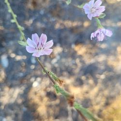
Flower Field in Glendale, California
Hiking Club in Glendale, California
Stroller Friendly Hikes in Glendale, California
Trending Searches in Glendale, CA
Black Owned Nail Salons near Brand Park
Jet Ski Rental near Brand Park
Off Road Trails near Brand Park
Outdoor Activities near Brand Park
Places To Walk Around near Brand Park
River Swimming near Brand Park
Running Trails near Brand Park
Scenic Night View near Brand Park
Scenic Overlook near Brand Park
Secluded Spots near Brand Park
Strawberry Picking near Brand Park
Swimming Holes near Brand Park
Browse Articles
Browse Nearby
BEST of Glendale, California Coffee near Brand Park
BEST of Glendale, California Restaurants near Brand Park
BEST of Glendale, California Things to Do near Brand Park
BEST of Glendale, California Breakfast near Brand Park
BEST of Glendale, California Walking Trails near Brand Park
BEST of Glendale, California Parks near Brand Park
BEST of Glendale, California Hot Springs near Brand Park
Browse Brands
Related Searches in Glendale, CA
Best Dog Hiking Trails Around Glendale, California
Best Fishing Locations and Guides in Glendale, California
Best Nature Trails for Hiking in Glendale, California
Best Places for Horseback Riding in Glendale, California
Check Out Off Road Trails in Glendale, California
Discover Dog Friendly Trails to Explore in Glendale, California
Discover Easy Hiking Trails Near Glendale, California
Discover Kid Friendly Hiking Trails in Glendale, California
Discover Popular Bike Trails in Glendale, California
Discover Scenic Mountain Bike Trails Near Glendale, California
Discover Walking Parks in Glendale, California Near You
Discover a Hiking Trail in Glendale, California
Discover the Best Night Hike Trails in Glendale, California
Dog-Friendly Hikes With Dogs in Glendale, California
Enjoy Camping Adventures Around Glendale, California
Enjoy Kayaking Adventures in Glendale, California
Enjoy Off Leash Dog Hikes in Glendale, California
Enjoy Scenic Places to Walk in Glendale, California
Enjoy a Beautiful Waterfall Hike in Glendale, California
Enjoy the Best Walking Path in Glendale, California
Enjoy the Best Walking Trails in Glendale, California
Explore Beautiful Parks and Green Spaces in Glendale, California
Explore Easy Hikes Perfect for All in Glendale, California
Explore Fun Activities to Do in Glendale, California
Explore Popular Campgrounds Near Glendale, California
Explore Popular Dog Walking Trails in Glendale, California
Explore Top Dog Parks in Glendale, California Near You
Explore the Best Beach Spots in Glendale, California
Family Friendly Hiking With Kids in Glendale, California
Find Beautiful Views in Glendale, California
Find Parks and Recreation Activities in Glendale, California
Find Top Dog Friendly Parks to Visit in Glendale, California
Find Top-Rated Waterfalls in Glendale, California Now
Find the Best Parks for Picnics in Glendale, California
Hiking Trails With Waterfalls in Glendale, California
Off Leash Dog Hiking Trails in Glendale, California
Popular Outdoor Activities to Try in Glendale, California
Popular Picnic Spots to Visit in Glendale, California
Popular Waterfall Hiking Trails in Glendale, California
Safe River Swimming Areas in Glendale, California
Safe and Fun Parks for Kids in Glendale, California
Top Hiking Trails to Explore in Glendale, California
Top Playgrounds for Kids to Enjoy in Glendale, California
Top Running Trails to Explore in Glendale, California
Top Swimming Lakes to Enjoy in Glendale, California
Top Swimming Spots and Pools in Glendale, California
Top-Rated Camping Sites in Glendale, California
People who viewed Brand Park also viewed
Descanso Trail
18 reviews
Cherry Canyon Park
24 reviews
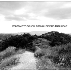
Scholl Canyon Fire Road Trailhead
7 reviews
La Canada Teepee
18 reviews
Oro Vista Park
7 reviews
Sunland
Eagle Rock Canyon Trail
32 reviews
Pacific Palisades
Flint Canyon Trail
8 reviews
Glendale Narrows Riverwalk
20 reviews
Griffith Park Helipad
15 reviews
Griffith Park
Big Tujunga Canyon
5 reviews
Sunland