
Griffith Park Helipad Photos


You might also consider


More like Griffith Park Helipad
Recommended Reviews - Griffith Park Helipad
Start your review...


Reviews With Photos


It takes us 25 min (1.2 miles)to hike up this spot love it then then off to a 3 and a / mile hike I love bring people to this spot if they never see all downtown LA before from up here


There are many ways you can hike to this location. I started at the Greek Theatre parking lot, there is a restroom in the area if you need it. You will cross the street, and look for the Riverside Trailhead Sign. Just follow this trail all the way to the end, do not turn on any side trails. At the end of the Riverside Trail, you will see a green building, turn right and about 250 feet is the helipad view point. The view of the city is nice for about an 2.8 mile round trip. From here, you can follow the same trail to return to your car. Or you can extend your hike and continue to quite a few places like Bee Rock, Beacon Hill, Glendale Peak or all the way to Mount Hollywood. Basically you can connect to any trails from here and go as far as you want:) If you do, I suggest printing out the trail map of the area. Below is a link I normally print out when venturing to a new section of the park. https://www.laparks.org/sites/default/files/griffith/pdf/GriffithParkMap.pdf As always pack accordingly to the weather and have fun.


Features: -I have to say, this hike had really good views of Los Angeles. It ranges from easy to moderate to hard, all very well balanced! -There are plenty of ways to get up to this Helipad but the exact address we used was 4400 Crystal Springs, LA. This takes you to a little area where you can use the restroom before the start of the hike. -The hike was a fairly short one, no longer than 2.5 hours depending on how much time you take to enjoy the beautiful views all around. We stopped maybe a handful of times and took several pictures and we were able to go up and come back down within 2.5 hours. -You can continue hiking pass the Helipad if you like, not exactly sure where it will take you but there are paved paths to follow. Improvement: -None Tips: -There are plenty of parking spots! -Once you have parked, walk across the street and the trail should be on the left. -Bring water, going up the hills can be strenuous.


This is one of the best places to get a view of DTLA. Far less people than the Hollywood Sign Hike and Griffith Observatory. Parking is located in residential area off Commonwealth Ave. Total "hiking" time to the pad takes about 20 minutes roughly. There are many other locations you can start from, but if you just wanna enjoy a short stroll to the top, I recommend you park on Commonwealth then. Once on top, you are met with a large giant concrete slab with a straight shot view of DTLA. Lots of bikers come here and overall, great place to stay for night shots. Park closes at 10:30 pm.


Griffith Park is an awesome hike for sight seeing, dog walking, a fun LA experience, and to break a sweat! This is one of my favorite hikes because of easy parking and the endless options for hiking trails. One of my favorites is starting at the bottom of Fendell and walking through the small nature museum and ending up at the very top of Griffith Park Helipad.


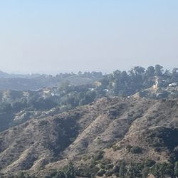
This review is for Hiking from Griffith Park Boulevard to Helipad in Griffith Park thru observation (vista) point and lovers bench. There's plenty of street parking at the end of the Griffith Park Boulevard where the trail starts. Hike trail is very nice, very green and clearly marked through fire roads. Cell phone works so if you can put the coordinates of the helipad, even Google will take you there. When you arrive to lovers bench, view of Los Angeles is very nice. Helipad is right next to the lovers bench. Highly recommend this Hike. They call that Vista point as lovers bench because it is narrated that supposedly two lovers died here because a tree branch collapsed on them. read more


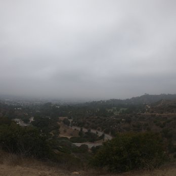
Great views of LA from this helipad. There are a few ways to get here. The easiest is from Commonwealth and Sunset (actually a few blocks up). There is a trailhead that will take you up to the helipad. There is a harder way via a hiking trail from within Griffith park as well. read more


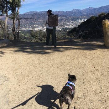
Great hike. If you're using Waze, type in Commonwealth Nursery Griffith Park, and it will take you to the trailhead. You'll park in a pretty wealthy looking neighborhood, so I felt like my vehicle was safe. We went today and there were still sand bags and mud puddles from the rain we just had. When you start from the trailhead at commonwealth, you'll walk up a slight hill (the golf course will be on the left) and there will be a fork in the road. Instead of going forward, take a right up the mountain, followed by another right. From here, you'll start up a gradual hill. You don't have to walk far before already seeing great views of the skyline. I'm not in shape and I could do it. A bit winded and sweaty, but doable for couch potatoes like myself. When you see a little green shack, you're pretty much there. The helipad will be on your right. There are a bunch of other trails you can take once you get to the helipad. We tried to do attempt continuing on to Bee Rock (1.5 miles) but my dog was exhausted so we turned around. Speaking of dogs, lots of cute pups walk this trail. Also, young children, teenagers, adults, and seniors (many seniors had hiking poles for support). So it definitely attracts a wide range of people. Pros: -great view -close, free, parking in a safe neighborhood -attracts a diverse spectrum of people -not an intimating hike if you're not in shape Cons: -not a well shaded hike unless you reach the helipad and continue to another trail, pending where the sun is. read more




6 years ago
It takes us 25 min (1.2 miles)to hike up this spot love it then then off to a 3 and a / mile hike I love bring people to this spot if they never see all downtown LA before from up here read more


8 years ago
There are many ways you can hike to this location. I started at the Greek Theatre parking lot, there is a restroom in the area if you need it. You will cross the street, and look for the Riverside Trailhead Sign. Just follow this trail all the way to the end, do not turn on any side trails. At the end of the Riverside Trail, you will see a green building, turn right and about 250 feet is the helipad view point. The view of the city is nice for about an 2.8 mile round trip. From here, you can follow the same trail to return to your car. Or you can extend your hike and continue to quite a few places like Bee Rock, Beacon Hill, Glendale Peak or all the way to Mount Hollywood. Basically you can connect to any trails from here and go as far as you want:) If you do, I suggest printing out the trail map of the area. Below is a link I normally print out when venturing to a new section of the park. https://www.laparks.org/sites/default/files/griffith/pdf/GriffithParkMap.pdf As always pack accordingly to the weather and have fun. read more



4 years ago

Features: -I have to say, this hike had really good views of Los Angeles. It ranges from easy to moderate to hard, all very well balanced! -There are plenty of ways to get up to this Helipad but the exact address we used was 4400 Crystal Springs, LA. This takes you to a little area where you can use the restroom before the start of the hike. -The hike was a fairly short one, no longer than 2.5 hours depending on how much time you take to enjoy the beautiful views all around. We stopped maybe a handful of times and took several pictures and we were able to go up and come back down within 2.5 hours. -You can continue hiking pass the Helipad if you like, not exactly sure where it will take you but there are paved paths to follow. Improvement: -None Tips: -There are plenty of parking spots! -Once you have parked, walk across the street and the trail should be on the left. -Bring water, going up the hills can be strenuous. read more


This is one of the best places to get a view of DTLA. Far less people than the Hollywood Sign Hike and Griffith Observatory. Parking is located in residential area off Commonwealth Ave. Total "hiking" time to the pad takes about 20 minutes roughly. There are many other locations you can start from, but if you just wanna enjoy a short stroll to the top, I recommend you park on Commonwealth then. Once on top, you are met with a large giant concrete slab with a straight shot view of DTLA. Lots of bikers come here and overall, great place to stay for night shots. Park closes at 10:30 pm. read more


8 years ago
Griffith Park is an awesome hike for sight seeing, dog walking, a fun LA experience, and to break a sweat! This is one of my favorite hikes because of easy parking and the endless options for hiking trails. One of my favorites is starting at the bottom of Fendell and walking through the small nature museum and ending up at the very top of Griffith Park Helipad. read more


11 years ago
Great views and nice area to hike to, stop for a break, or even picnic. I love the Griffith Park trails because they are dog friendly and well maintained. There are a number of trails that take you to the helipad, so take your pick! I usually park by The Greek and take the trail across the street which I believe is the Riverside Trail. read more


11 years ago

12 years ago

10 years ago
More info about Griffith Park Helipad
Vista Del Valle Dr
Los Angeles, CA 90027
Griffith Park
Directions
Hours
Outdoor Amenities
Ask the Community - Griffith Park Helipad
Review Highlights - Griffith Park Helipad
You might also consider















Why does Yelp recommend reviews?
1 review that is not currently recommended
The reviews below are not factored into the business's overall star rating.

4 years ago


