Mt. Wilson Trail Photos


You might also consider
More like Mt. Wilson Trail
Recommended Reviews - Mt. Wilson Trail
Start your review...

Reviews With Photos

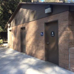
Mt. Wilson is such a great and fun climb. It's long but not overly challenging or technical. I was looking forward to the cafe at the top, but they were closed for the winter. A couple of people told us they spotted bears. The descent towards the parking lot seemed long. The hike is about 15 miles with 4,400 ft of elevation gain. My favorite part though and the primarily reason why I would do this hike again and again is the amazing ice cream shop in town! Mother Moo Creamery has the most amazing homemade ice cream and pies and anything and everything they make. I will do anything, absolutely anything for good ice cream. Easy parking and there is a very disgusting bathroom at the trailhead. Come and create your own adventure.

It's my 5th time doing Mt Wilson Peak with my husband and we love it every time. It's a hard hike, be prepared you need Good hiking shoes Water Electrolytes Hat if its hot Hiking Poles Crampons if there's snow. Snacks and a sandwich. Better to be prepared than sorry later we saw many people without water and with the wrong shoes dying. Park at these address not need an adventure pass. 189 E. Mira monte ave. Sierra Madre. Ca 91024 There are bathrooms at the park next to the entrance and at the top of Wilson Peak. Enjoy the trails and please leave no trace.

This is such a nice hiking trail, and the view is epic. It was quite challenging to me. I love that they have many fun points along the trail. I know some people can hike from early morning to sunset since this trail can go for more than 15 miles, but we chose the shorter one. We hiked to the Little Fall, and it took us total 2 hours for the round trip. We parked on the side, and there was plenty of parking since we started at 5 pm. I would definitely come back again and hike for a longer duration. Haha! Oh, make sure to bring enough water and some snack, the trail is steep, would burn more calories.

Have visited the Mt Wilson Trails more than five times. The last four times I can only make it the first water. Today I make it to the second water, 3 miles away from where I started. Along the trails you can see a good view away and go through the small creek. It's getting challenging after first water and it's getting humid when you climb up. We started at 11:30 and finally were back in 3:10 PM. Easy street parking. Mind the gap and you might see a little snake in your way. But overall it's quite worth a visit for the hike. We will be back for another season.


Trigger warning: if you have vertigo or are sensitive to accounts of anxiety-related deaths by bizarre means, please be advised that this review contains sensitive content on these topics. Reader discretion is advised. Falling to my death off a precipitous cliff. Being killed in a landslide. Being trampled by a rampaging mule deer and *then* falling to my death off a precipitous cliff. These were not things that I imagined worrying about as I planned for a calming, lovely hike in nature. You know, going out into green space to relax, improve my mental health and reduce stress. That's what you're supposed to do, right? It all started out just fine. I found the trailhead easily with Yelp directions, parked, and took off with my phone, water bottle and daypack including a whistle (just in case. I thought I was being paranoid.) The trail starts out in residential Sierra Madre, so it felt like a typical urban hike in the Los Angeles area. You are surrounded by houses, start off at the trailhead, and begin the adventure. Up, up, up. Then, all of a sudden, you're far above the city and the buildings start to look like dollhouses down below. You realize that the San Gabriel Mountains have a well-earned reputation as one of the steepest mountain ranges around. You notice that there is no guardrail between you and a fall to certain death, with only yucca and buckwheat to save you. You peek over the edge and wish you hadn't. You begin to get dizzy. You then hear a noise behind you. You turn slowly to see rocks falling from the mountain side above directly onto your path. You realize that there has been a sizeable landslide right in that very spot and that the mountainside could actually give way at any moment. One good shaker (this is California, after all) and you're toast. You decide to sit down on a nearby boulder and have a snack. Feeling refreshed, you focus on the gorgeous wildflowers of spring. You decide to make it to First Water, stopping along the way and trying not to look off into the abyss. First Water is gorgeous, with lovely trees and (true to billing) running water. Coming back, you almost run headfirst into a deer galloping down the trail and up the mountainside. (I am not sure why I switched into second person but let me just say this is all true. I am not sure who was more scared, the deer or me. If I had been a few feet closer, the deer would have run into me and I might have fallen off the edge.) You thank your lucky stars and march straight back to the trailhead. I notice that quite a few of the locals carry cowbells with them. They can be heard up and down the trail, making it feel like you're up on a dairy farm in the Swiss Alps. I asked one of them why and they said "In case of an emergency." See? It's not just me. Even the locals are aware that they could fall off the trail and be stranded like a Swiss goat. I have been on steeper trails, it's true, but this trail is something else with the precipitous falling away sides of the trails down cliffs. The trail is very well maintained and well-marked. It's absolutely gorgeous in spring. But if you have even a touch of vertigo (which admittedly I do, my DNA report even said so), consider yourself warned. Five stars for natural beauty and well-maintained hiking trails. Free. Free street parking as well. P.S. Make sure your shoes have good tread! (And that your affairs are in order. Just kidding.)

Great hike if you are looking for a challenge! My hiking crew came on 4/16 and the conditions were perfect for a long trek; cloud coverage most of the day, light mist and moderately trafficked. When you do this hike, there are going to be times when you want to quit, but just remember, a cafe/snack bar awaits you at the top. Highly recommend brining snacks, 2L of water and tracking poles on the hike. Enjoy!

tl,dr: Fantastic exercise training! Dangerous moments along the trail. Grateful for a cafe with various food at the peak. Observatory's aite. 9/10 would do again. Likes: + Spectacular strenuous exercise. + Very considerate cafe at the summit. With restrooms and water refill. + PLENTY of shade throughout the trail. + Predominantly one way up and down; can't really get lost. Just a couple forks overall, but follow the online guides. Non-likes: - Dangerous moments. Occasionally you'll have to hop across a very narrow ridge. Cliff wall on one side, a steep drop on the other. Watch for loose footing! - Yucca plants galore. The one pictured below stabbed my left temple as I was tryna squeeze through the narrow trail and keeping an eye on the ground to avoid stepping on the rocks. At Mt Wilson Observatory, a kind lady explained various astronomers' contributions to astronomy and Mt Wilson's history behind them. Another guy was unclear about how I could access the 100-inch telescope, which was closed in the middle of the day for no apparent reason...
")
This trail definitely made it into my top 5 for the area! Yeah it packs quite an incline on the way up - but it's no worse than Echo Mountain. Actually might be slightly less than Echo. We just did the First Water Trail and ended up at 4.4 miles and had gained 1180+ feet - but the incline is all on the way in and downhill all the way out, which is how I like it! I'd call this trail moderate. There's a split off about halfway with a sign - go left for "Charlie's New Trail" or right for the "Old Mt Wilson" trail. We were feeling adventurous and explored Charlie's New Trail!! It was awesome - waaaaayyy less traffic - the regular trail was packed - but it was Sunday morning so no surprise there. We took the Old Mt Wilson trail back down. I think Charlie's New Trail may be just a tad longer but the inclines seemed similar. There's also another fork in the road at the end of this First Water trail - go left for Orchard Camp or right for "First Water" where you'll find a nice bench and a lovely area with lots of small falls and pools, tons of trees and shade and boulders - and if you're brave and venture to the left past the falls, the trail is just like a fairy land! I loved it! Peaceful and serene! Great place to take pics too. The trail is pretty narrow and can be rocky. We didn't use any poles - but I highly recommend decent hiking shoes. It's well marked so you won't get lost. There are some steep drops in places so just be aware of your footing and of passing trail runners. There's some shade in places, especially at the start and at the First Water area - but you'll for sure need sunscreen - I'd say the trail has about 30-35% shade overall. Parking is street parking in the residential area and gets super busy - I highly recommend you come early. We got there before 8am Sunday and had to park waaaay down. There is a bathroom in the city park nearby but it was out of order on our visit this past Sunday (1/31/21). Looks like there's a couple of cute museums near the city park part by the trailhead too!
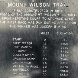
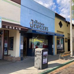
Quick tips: 1) Don't come with an empty stomach, hiking here is real! There's no place for you to sit or rest or relax, only if you make it to first water(1.5+ miles). Pack yourself enough water + Eat something first! 2) Don't come when you're too full. (Lol!) All uphill, it is a nightmare to hike when you're completely stuffed! (Oh yes, I struggled!) 3) The hike starts at Mount Wilson Trail Park. The bathroom is the building in the back. (But we didn't find it) Try to go before you come here. 4) Again! All uphill! The view is amazing along the trail but keep in mind, not the easiest for beginners! It can be challenging even just hike to first water! Get prepared! 5) Some rocky roads! Hiking shoes/boots are needed for safety in my opinion! And, if you're planning to hike up to Mt. Wilson, (7 miles) hiking gear is much needed! 6) Free parking on the street, only takes a few minutes to walk to the trailhead. (But if you get here late, you've gotta park farther away.) 7) There are quite a few restaurants for you to explore after hiking in Sierra Madre! It's a cute lovely town! The Mt. Wilson trial, first constructed in 1864, is one of the oldest trial that offers really beautiful views for runners and hikers! Highly recommend to someone who's not afraid of heights. (So beautiful! It's a hidden gem!) All residents, hikers and runners were pretty friendly here. Dog friendly is a plus! But I feel like this is not the safest trail for kiddos (the path is kinda narrow) and doggies(leash is needed for safety), since there are no fences or any protections along the trail, it can be scary at times; nonetheless, the view is unbeatable, still one of the best in my opinion! Worth exploring!

This review is only for the hike up to orchards, which is almost half way to the top of the mountain Wilson. Parking is really easy, you can find street parking with no limitation. There is a small park and a tiny museum at the trailer entrance, park has very clean restrooms. It is very easy to find the trail head. A quick warning that this is a very difficult hike and it is constantly uphill. Second warning is that if you have a fear of heights, a good portion of this Hike is walking at the edge of the mountain next to Cliff which is very high. This is a very, very beautiful hike, especially if you're doing it during spring or fall seasons when the weather is nice. Be careful in summertime, a portion of this hike may get extremely hot. Make sure you have hiking poles, they helped a lot.

This is an amazing trail, however parts of it are almost vertical. Today I accidentally hiked this trail for the second time in the wrong direction. I zigged when I should have zagged and ended up going straight up a sandy water torn embankment. Around 1,200 ft ascent over a very short distance. Parts of the trail are quite doable Even with a child in tow.

I went during the winter right after a good rainfall. We started the hike around 1:00pm and it was still not too hot. We hiked to the Lower First Water Junction. I would recommend bringing some water and snacks to be able to enjoy at the stream. It is also a nice place to hang out for lunch. The stream is super cold but refreshing after a hike. I would recommend wearing some warm clothing because it was cold when going back down the mountain. Please take your trash with you to keep Mt. Wilson clean for others to enjoy.

2 months ago
This place is great but if you are planing to go all the way up you must know that it's 8 miles so that's 16 miles back and forth also take lot of water, electrics and Gatorades. read more


4 months ago
This is an amazing place to visit and be in touch with nature, I have seen deers just walking around just like we all belong here read more


4 months ago
Mt. Wilson is such a great and fun climb. It's long but not overly challenging or technical. I was looking forward to the cafe at the top, but they were closed for the winter. A couple of people told us they spotted bears. The descent towards the parking lot seemed long. The hike is about 15 miles with 4,400 ft of elevation gain. My favorite part though and the primarily reason why I would do this hike again and again is the amazing ice cream shop in town! Mother Moo Creamery has the most amazing homemade ice cream and pies and anything and everything they make. I will do anything, absolutely anything for good ice cream. Easy parking and there is a very disgusting bathroom at the trailhead. Come and create your own adventure. read more

It's my 5th time doing Mt Wilson Peak with my husband and we love it every time. It's a hard hike, be prepared you need Good hiking shoes Water Electrolytes Hat if its hot Hiking Poles Crampons if there's snow. Snacks and a sandwich. Better to be prepared than sorry later we saw many people without water and with the wrong shoes dying. Park at these address not need an adventure pass. 189 E. Mira monte ave. Sierra Madre. Ca 91024 There are bathrooms at the park next to the entrance and at the top of Wilson Peak. Enjoy the trails and please leave no trace. read more


3 years ago
This is such a nice hiking trail, and the view is epic. It was quite challenging to me. I love that they have many fun points along the trail. I know some people can hike from early morning to sunset since this trail can go for more than 15 miles, but we chose the shorter one. We hiked to the Little Fall, and it took us total 2 hours for the round trip. We parked on the side, and there was plenty of parking since we started at 5 pm. I would definitely come back again and hike for a longer duration. Haha! Oh, make sure to bring enough water and some snack, the trail is steep, would burn more calories. read more


Have visited the Mt Wilson Trails more than five times. The last four times I can only make it the first water. Today I make it to the second water, 3 miles away from where I started. Along the trails you can see a good view away and go through the small creek. It's getting challenging after first water and it's getting humid when you climb up. We started at 11:30 and finally were back in 3:10 PM. Easy street parking. Mind the gap and you might see a little snake in your way. But overall it's quite worth a visit for the hike. We will be back for another season. read more


Amazing views, beautiful trails a great getaway for a day a great hike, keeping your mind and body fit. We had a great time and stood long enough to watch Sunset. It was my first time visiting, but surely I'll be back again soon. read more


Trigger warning: if you have vertigo or are sensitive to accounts of anxiety-related deaths by bizarre means, please be advised that this review contains sensitive content on these topics. Reader discretion is advised. Falling to my death off a precipitous cliff. Being killed in a landslide. Being trampled by a rampaging mule deer and *then* falling to my death off a precipitous cliff. These were not things that I imagined worrying about as I planned for a calming, lovely hike in nature. You know, going out into green space to relax, improve my mental health and reduce stress. That's what you're supposed to do, right? It all started out just fine. I found the trailhead easily with Yelp directions, parked, and took off with my phone, water bottle and daypack including a whistle (just in case. I thought I was being paranoid.) The trail starts out in residential Sierra Madre, so it felt like a typical urban hike in the Los Angeles area. You are surrounded by houses, start off at the trailhead, and begin the adventure. Up, up, up. Then, all of a sudden, you're far above the city and the buildings start to look like dollhouses down below. You realize that the San Gabriel Mountains have a well-earned reputation as one of the steepest mountain ranges around. You notice that there is no guardrail between you and a fall to certain death, with only yucca and buckwheat to save you. You peek over the edge and wish you hadn't. You begin to get dizzy. You then hear a noise behind you. You turn slowly to see rocks falling from the mountain side above directly onto your path. You realize that there has been a sizeable landslide right in that very spot and that the mountainside could actually give way at any moment. One good shaker (this is California, after all) and you're toast. You decide to sit down on a nearby boulder and have a snack. Feeling refreshed, you focus on the gorgeous wildflowers of spring. You decide to make it to First Water, stopping along the way and trying not to look off into the abyss. First Water is gorgeous, with lovely trees and (true to billing) running water. Coming back, you almost run headfirst into a deer galloping down the trail and up the mountainside. (I am not sure why I switched into second person but let me just say this is all true. I am not sure who was more scared, the deer or me. If I had been a few feet closer, the deer would have run into me and I might have fallen off the edge.) You thank your lucky stars and march straight back to the trailhead. I notice that quite a few of the locals carry cowbells with them. They can be heard up and down the trail, making it feel like you're up on a dairy farm in the Swiss Alps. I asked one of them why and they said "In case of an emergency." See? It's not just me. Even the locals are aware that they could fall off the trail and be stranded like a Swiss goat. I have been on steeper trails, it's true, but this trail is something else with the precipitous falling away sides of the trails down cliffs. The trail is very well maintained and well-marked. It's absolutely gorgeous in spring. But if you have even a touch of vertigo (which admittedly I do, my DNA report even said so), consider yourself warned. Five stars for natural beauty and well-maintained hiking trails. Free. Free street parking as well. P.S. Make sure your shoes have good tread! (And that your affairs are in order. Just kidding.) read more


4 years ago
Great hike if you are looking for a challenge! My hiking crew came on 4/16 and the conditions were perfect for a long trek; cloud coverage most of the day, light mist and moderately trafficked. When you do this hike, there are going to be times when you want to quit, but just remember, a cafe/snack bar awaits you at the top. Highly recommend brining snacks, 2L of water and tracking poles on the hike. Enjoy! read more


tl,dr: Fantastic exercise training! Dangerous moments along the trail. Grateful for a cafe with various food at the peak. Observatory's aite. 9/10 would do again. Likes: + Spectacular strenuous exercise. + Very considerate cafe at the summit. With restrooms and water refill. + PLENTY of shade throughout the trail. + Predominantly one way up and down; can't really get lost. Just a couple forks overall, but follow the online guides. Non-likes: - Dangerous moments. Occasionally you'll have to hop across a very narrow ridge. Cliff wall on one side, a steep drop on the other. Watch for loose footing! - Yucca plants galore. The one pictured below stabbed my left temple as I was tryna squeeze through the narrow trail and keeping an eye on the ground to avoid stepping on the rocks. At Mt Wilson Observatory, a kind lady explained various astronomers' contributions to astronomy and Mt Wilson's history behind them. Another guy was unclear about how I could access the 100-inch telescope, which was closed in the middle of the day for no apparent reason... read more

This trail definitely made it into my top 5 for the area! Yeah it packs quite an incline on the way up - but it's no worse than Echo Mountain. Actually might be slightly less than Echo. We just did the First Water Trail and ended up at 4.4 miles and had gained 1180+ feet - but the incline is all on the way in and downhill all the way out, which is how I like it! I'd call this trail moderate. There's a split off about halfway with a sign - go left for "Charlie's New Trail" or right for the "Old Mt Wilson" trail. We were feeling adventurous and explored Charlie's New Trail!! It was awesome - waaaaayyy less traffic - the regular trail was packed - but it was Sunday morning so no surprise there. We took the Old Mt Wilson trail back down. I think Charlie's New Trail may be just a tad longer but the inclines seemed similar. There's also another fork in the road at the end of this First Water trail - go left for Orchard Camp or right for "First Water" where you'll find a nice bench and a lovely area with lots of small falls and pools, tons of trees and shade and boulders - and if you're brave and venture to the left past the falls, the trail is just like a fairy land! I loved it! Peaceful and serene! Great place to take pics too. The trail is pretty narrow and can be rocky. We didn't use any poles - but I highly recommend decent hiking shoes. It's well marked so you won't get lost. There are some steep drops in places so just be aware of your footing and of passing trail runners. There's some shade in places, especially at the start and at the First Water area - but you'll for sure need sunscreen - I'd say the trail has about 30-35% shade overall. Parking is street parking in the residential area and gets super busy - I highly recommend you come early. We got there before 8am Sunday and had to park waaaay down. There is a bathroom in the city park nearby but it was out of order on our visit this past Sunday (1/31/21). Looks like there's a couple of cute museums near the city park part by the trailhead too! read more
 - Parks Near Me - Sierra Madre, California")


6 years ago
Quick tips: 1) Don't come with an empty stomach, hiking here is real! There's no place for you to sit or rest or relax, only if you make it to first water(1.5+ miles). Pack yourself enough water + Eat something first! 2) Don't come when you're too full. (Lol!) All uphill, it is a nightmare to hike when you're completely stuffed! (Oh yes, I struggled!) 3) The hike starts at Mount Wilson Trail Park. The bathroom is the building in the back. (But we didn't find it) Try to go before you come here. 4) Again! All uphill! The view is amazing along the trail but keep in mind, not the easiest for beginners! It can be challenging even just hike to first water! Get prepared! 5) Some rocky roads! Hiking shoes/boots are needed for safety in my opinion! And, if you're planning to hike up to Mt. Wilson, (7 miles) hiking gear is much needed! 6) Free parking on the street, only takes a few minutes to walk to the trailhead. (But if you get here late, you've gotta park farther away.) 7) There are quite a few restaurants for you to explore after hiking in Sierra Madre! It's a cute lovely town! The Mt. Wilson trial, first constructed in 1864, is one of the oldest trial that offers really beautiful views for runners and hikers! Highly recommend to someone who's not afraid of heights. (So beautiful! It's a hidden gem!) All residents, hikers and runners were pretty friendly here. Dog friendly is a plus! But I feel like this is not the safest trail for kiddos (the path is kinda narrow) and doggies(leash is needed for safety), since there are no fences or any protections along the trail, it can be scary at times; nonetheless, the view is unbeatable, still one of the best in my opinion! Worth exploring! read more


This review is only for the hike up to orchards, which is almost half way to the top of the mountain Wilson. Parking is really easy, you can find street parking with no limitation. There is a small park and a tiny museum at the trailer entrance, park has very clean restrooms. It is very easy to find the trail head. A quick warning that this is a very difficult hike and it is constantly uphill. Second warning is that if you have a fear of heights, a good portion of this Hike is walking at the edge of the mountain next to Cliff which is very high. This is a very, very beautiful hike, especially if you're doing it during spring or fall seasons when the weather is nice. Be careful in summertime, a portion of this hike may get extremely hot. Make sure you have hiking poles, they helped a lot. read more


This is an amazing trail, however parts of it are almost vertical. Today I accidentally hiked this trail for the second time in the wrong direction. I zigged when I should have zagged and ended up going straight up a sandy water torn embankment. Around 1,200 ft ascent over a very short distance. Parts of the trail are quite doable Even with a child in tow. read more

I went during the winter right after a good rainfall. We started the hike around 1:00pm and it was still not too hot. We hiked to the Lower First Water Junction. I would recommend bringing some water and snacks to be able to enjoy at the stream. It is also a nice place to hang out for lunch. The stream is super cold but refreshing after a hike. I would recommend wearing some warm clothing because it was cold when going back down the mountain. Please take your trash with you to keep Mt. Wilson clean for others to enjoy. read more

One of the most challenging and rewarding hikes! I started at the the Mt wilson trailhead. I took Charlie's new trail to Jone's peak. Be careful on this section as there is a lot of loose soil and it is steep. Jone's peak was beautiful but it is far from the actual peak. From Jone's peak, I took the connecting trail to Ruby Wilson Point. Ruby Wilson Point was absolutely beautiful. There was a bench there that was situated in the clouds and I could have spent the whole day there. I definitely recommend pushing to Ruby Wilson Point trail if you're by Jone's peak. After taking my break at Ruby Wilson Point I pushed further up the mountain to connect with the Mt Wilson Toll Road trail. There is a point where the trail get extremely steep. However there is a steel cable that helped me climb up. Once passing the steel cable there is a fork in the road. If you go left it connects with Eaton Canyon. I went right to head the Mt wilson peak. It took me nearly 4 hours to reach the peak (5.8 miles). I am an avid hiker and have been regularly taking on black diamond & double black diamond trails but this one pushed me. I rarely ever take breaks while hiking but I found myself having to stop 4 times just going up. I made it to the the peak! There is a little cafe at the top with an observatory. I stopped to get a diet coke at the cafe and walk around the observatory. I took some photos and started my descent. I took the easier way down as the way that I took up was way too steep for me to take back for a descent. I followed the Mt Wilson trail down to the bench and through 4th water. I took 4th water to orchard camp. I took a break at orchard camp. Finally I pushed through 2nd and 1st water and finished my climb down. It was grueling. It tested not just my body but also my mind. I am glad I did the hike. It was hard and my legs are very sore. Do not attempt this route if you have bad knees. Do not attempt this route without proper hiking shoes. BRING LOTS OF WATER. I went through 1.5 liters of water on the way up and 1 liter of water on the way down. Luckily on the way down there is a good amount of shade in the afternoon. The hike to the top was worth it but I'm not sure that I would ever do it again. It was truly a painful hike. Don't get me wrong, it was beautiful but it is not for the weak. I would definitely hike to Ruby Wilson point again. I look forward to returning to this mountain. read more


How have I not been on this hike yet? My hiking buddy and I came here on a Saturday morning around 8am and this place was already packed with hikers/cars parked. Guess it was because the weather was finally nice and people wanted to take advantage. The plus to this hike is that there is a restroom in the park nearby. Also a good thing for me! The hike itself is a little over 3 miles but the path is pretty narrow and some parts were steep. There were a lot of people with dogs on this hike, many of them not on leashes so we had to block them from my friend's dog who is not the friendliest. Overall it was a great hike with some really nice views. Definitely worth checking out! read more


I've been hiking this trail for about 11 years! It's the closest and toughest hike in the L.A. area. Since the pandemic, the trail has become more heavily trafficked and damage has been done both by people and wild fires. Glad to see people going to nature, but pick up your trash and stop tagging please! That includes your t.p. if you leave it at least use your foot to make a hole and burry it...not that hard people!! Your laziness and inconsiderate nature shows that you're not happy, maybe work on your happiness and take it out by being kind to yourself so you can be kind to others and nature. This trail is a great butt burner. If you're just going to first water you'll get your 10,000 steps in within a few hours since there are some steep parts. This trail isn't for those who are just beginning to hike unless you're athletic. You'll find some die hard trail runners, hikers, and really strong old Korean/Chinese/ ladies who will hike faster than you on this thing!! As of lately, the city of Sierra Madre has been ticketing cars that park on the service drive (the private road that leads to the trail). I'm not sure why, they've never done it before. The signs there can be misleading one side says no stopping anytime with arrows pointing a certain way. I've also seen tickets on cars on Mira Monte too, again not sure why when there is no signs saying to not park there. I've parked on Mira Monte for years. There's a guy on a bicycle giving tickets wearing a reflective vest...is he legit?? I don't know but the tickets on the cars looked legit. This trail is always like 10 degrees hotter than where most people live because the mountains hold in the heat. The best times to go if you want to see less people is on weekdays. Or, later hours 4pm to sunset on weekends. Give it a shot, it's a nice trail to get out of the city for a bit. read more


I love all kinds of nature hikes, especially thru the mountains, trees, away from the city, away from people, you get the idea. That way, I get to meditate to clear my mind tackling new challenges. Like everyone else mentions, arrive early to get street parking, like before sunrise at 6 am. I got here at 7:30 am but was booted over from the now closed for fire rehab Sturtevant Falls. I was really happy this one was still open; however, the museum was closed. Also, there was one public bathroom available in the park. It was my first time, and I only hiked up to the First Water ~2 miles and then backed down again in the heat. Few tips: - bring a camel for water. Otherwise, make sure to bring enough water end to an end 14 miles. That's a little over a marathon in case you decide to do it! - bring food snacks; you will get hungry, and there is no food on top of Mount Wilson. - wear sunblock. I did not, so I got very tanned haha, bring comfortable hiking shoes. - wear in layers does get chill then hot again due to the sun. - again, arrive early for the cooler weather. I thought wrong; as a result, I ended up baking for half a day. Take a very long time, not for the faint of heart, if you intend to climb to the top. The last thing you want to wander around in the dark - the trails are very challenging. - be careful some rocks have moisture/water as I ended up slipping off one big wet stone and used my hand to stop the fall ouch. - bring bug spray, they say. - say good morning with a smile; almost everyone is friendly! :-) Good luck! I will return hopefully soon. read more


So far I'm 4 trails into the 6 peek challenge (Baldy, Cucamonga, & San Jacinto) and this one was my favorite simply for the fact that it's not as strenuous with the inclines & elevation gains. It's definitely one of the longer hikes distance wise but that made it more enjoyable in comparison since I wasn't really struggling with up hills & switch backs for one. The elevation for the peek isn't that high compared to the other trails with the peek being below 6000 feet there aren't really any great views to see the city down below, but facing north where the Mt. Wilson peek sign is there's some nice views of how far out the mountains go. The beginning of the trail head from the parking area there's a restroom before heading down into the trail, once you get about 1/4 a mile down there's a split for the Gabrielion trail that's 6.4 miles to the Wilson peek, or the Lower Winter creek trail that 6.25 to the Wilson peek. You can take either one & they loop together at the top so you be able to do both trails in one trip. The first 4 miles of the trail is pretty much forest like with a lot of trees and shade. Once you're at the top there's a cafe, water filling station, restrooms, & the Wilson observatory with two big telescopes. On the return down we took the Lower winter creek trail which went through Sturtevant Camp & Falls, unfortunately the time of year we went the water wall was dried up and hand nothing but a few drops coming down. But overall it's a solid nature walk-ish kind of hike with a decent amount of elevation gains. The total mileage was between was around 16 miles, maybe 17 depending on how far you had to park. Not a hike I'd recommend for beginners, but if the inclines on the other 5 peeks seem like a bit much, this one is a good start if you plan on doing to other peeks in the future. read more

 we found a bench with some nice views and cell phone reception. - Parks Near Me - Sierra Madre, California")


2 years ago
4 years ago
This hike is the first I completed for the Six Pack of Peaks Challenge! I read that the trail via Chantry Flats was closed so we went via this Mt. Wilson Trail. Round trip was about 15 miles! We started at 7am, ate lunch at the peak, and made it back to the trailhead around 2:30pm. It's a long & tiring hike. You can tell that this trail is well taken care of, even though a good amount of people go through. More than half the hike is not shaded so pack a hat, sunglasses, & sunscreen. There is a bathroom at Mt. Wilson Trail Park at the bottom of the hike, and bathrooms at the top of the peak too. Always love a hike with a bathroom lol. I would suggest to bring a lot of water, snacks, & pack a lunch to enjoy at the tables with a view at the top! read more


It's all incline from the start. Take it easy take your time enjoy the views this is a great hike to do especially if you're working out after the holidays. Please be mindful wear your masks so this trail doesn't get shut down too. There is a box providing free masks at the trailhead that an awesome boyscout or Eagle Scout so graciously made and provided so grab one in case you forgot yours. Also please respect the private property residential signs and respect the surrounding neighborhood. Thanks in advance stay safe out there! read more


4 years ago
6 years ago
Very challenging hike! I got sore for 3 days straight Very rewarding view!! I felt like I died and came back to life some key points 1) all the way is going up so watch your back position or you can hurt yourself 2) bring lots of water and a few snacks because you ll be hiking for about 6 hours 3) it's awesome how in some areas is all sunny and hot but in others is so tropical and full of little waterfalls and trees!! 4) a bunch of mosquitoes, I heard that eating garlic before hand helps 5) watch out! Don't go back down at night, it's hard to see the cleavage of the floor and you can fall 6) the trail is well made, so everybody can do it. It is very safe read more


Fun fact: Only female mosquitoes feed on blood. Not so fun fact: This trail has a swarm of them on some days. I swear! On the day I hiked this trail, these blood-sucking a-holes had it out for me from the beginning. They followed me for 14 miles! And they went through my clothing. I put on mosquito repellant, but it wasn't enough. I was sweating it off and got 'bit' an exorbitant amount. Not fun! I've been going for the Southern California's six pack of peaks hikes in preparation for Mt. Wilson. This will be 4 of 6. I could confidently say, this is my least favorite. The hike is approximately 14 miles up and back with 4200' elevation gain. The peak rises at about 5700' above sea level. It houses the Mt. Wilson Observatory where you can walk around and enjoy the view. I probably would've enjoyed it more if not for those mean flying blood-sucking punks who ganged up on me during this hike. How dare they?! Would I do this hike again? Probably not. But I'm looking forward to the rest of the six pack of peaks! read more


To be around nature is the best kind of aphrodisiac. And so my adventure begins around 0930 am. Mount Wilson Trail with Jones Peak and Bailey Canyon Loop is a 14.9 mile loop trail located near Sierra Madre that features beautiful wild flowers, wild cats, eagles, bees and lizards. This trail is recommended for experienced hiking adventurers. Dogs are also able to use this trail but must be kept on leash. The trails were well kept and wide but it gets narrower as you ascend and you'll definitely feel your legs and thighs. However, the view of the mountain and terrain were amazing as you elevate. The highlight of my hiking adventure was seeing a Bobcat on the trail. Yass!! He vanished around the corner as I approach. Probably got scared by a Panda. Today, there were very few hikers, some masked while others aren't. But can you blame them its bloody 85 degrees and you're hiking. I reached the First Water Bench at 1,089 ft and explored the water stream a few feet below. It was nice to cool off a bit and under the trees. I went back to the trail and headed north. After a few mile or so, I decided to head down back because I ran out of water. Going down I was jogging and walking and enjoying the mountain view. In this voluminous review, I truly enjoyed this trail and its amazing view. Overall, I highly recommend Mt Wilson trail in Sierra Madre. I will definitely return. read more


4 years ago
They added this beautiful sign (: This trail is definitely for experienced hikers looking for something different and difficult to overcome. My dad climbed this trail with me after his knee surgery. Makes you definitely feel like you can conquer the world! read more


6 years ago
We started this hike at 7am from the Mt. Wilson trailhead near'Lizzies Trail Inn' on E. Mira Monte road. This hike was long and pretty strenuous. Not gonna lie, my feet are hating me right now. Lots of incline (especially after you reach Orchard campsite which is halfway to Mt Wilson Observatory). It took us 4.5 hours to reach the top and 3.5 on the way down. Oh my, the way down... make sure you are wearing good fitting hiking shoes the prevent your toes from hitting the front of the shoe. What started off as not a big deal turned into a big deal cuz my toes hurt like hell after about 1 hour of descent. I read a lot about bugs but I saw almost none. Of course the snow may be reason. I'd say the top 1/3 of hike was in ankle deep snow. A lot of fun & super pretty but difficult to walk in if you don't have the grips or spikes you can slide over bottom of boot. Lastly: be smart about layering and bringing food & water. I ran into people needed water because the ONE bottle they were sharing was empty. If you need some references to the trail: Thehikingguy.com has awesome pictures with arrows pointing to where you wanna go at forks in the trail. read more


SPOILER If you've seen my previous hike reviews as much as I am for adventures and the art of getting lost, sometimes I am on a time constraint. As much as I enjoyed the experienced and time wandering in the wild, I REALLY needed to get where I needed to be. Directions: This is in Los Angeles Forest. This direction is going towards Sturtevant Falls trails (Chantry Flats). See other reviews for different directions. Hiking Difficulty: Medium/Hard The hiking spot itself is great! You have choices from taking pictures at a waterfall, jumping off a rock, summitting to a high peak, or seeing an observatory. What made this tough was the length, incline, and the bugs. It did require a lot of patience, sunblock, bugspray, and breaks. Some parts of the trails were thin but nothing extremely steep. The view was pleasant and there weren't a lot of shaded areas which worked for us. A nice hike for semi-serious hikers...this is not a cute hike. Advice: * Bring food, bug spray/net, sun block, hiking shoes, and water, * 1 of the Six Pack of Peaks Challenge * This is no hidden gem. Come around 7am or earlier for parking * Adventure Pass applies for legit parking spaces and not on the hill. * Food and souvenirs can be found near the observatory. read more


My friends and I are on the quest to conquer the 6 Pack Peak Challenge this year. Mt Wilson is the 1st and shortest peak. I thought I was in good shape but this hike really beat me up. It took my friend and I 3 hours up (no breaks) and about 2.5 hours down (no breaks and semi jogging). My body is still sore, my feet has callouses, but the feeling of accomplishment overcomes all of that. We started at Chantry Flats which is about 15 miles round trip (more if you can't find close parking). The scenery is beautiful specially now that its all green and there is tons of water. Remember to get an adventure pass to park and park properly as tons of people got tickets. Bring water, snacks and bananas in case you cramp up. Great 1st peak! read more


My 52nd hike of 2016. I took on the 52 Hike Challenge and wanted to pick a memorable hike for the 52nd. Parking- we parked at Chantry Flats...the same parking lot that is used for Hermits Falls and Sturtevant Falls; you must have an Adventure Pass ($5), Annual Pass ($30), or buy 2 Annual passes at Big 5 for $35 which we did. Trail- we used the same trail as the Sturtevant Falls trail...about 1/2 mile from the falls you will see a sign to the left leading to the upper falls and that trail will lead you past the top of the falls and eventually to Sturtevant Camp where the huge swing is...the trail up to this point is not too hard, but the trail from this point on is very difficult and just a steady incline that feels like it goes on and on; when you reach the top I suggest you go to the right since there is a cool look out area for pictures; Top- I was surprised how large it was at the top...a lot to see and it all seems so far apart when you are exhausted from the 7+ miles you just walked up; restrooms and a small place to get a bite to eat at Cosmic Cafe...I wasn't that impressed with the sandwich and chili that I got...but still good to have an option if you don't want to pack your own food Time- we started at 6:15 and arrived at the top at about 10:45, so about 4.5 hrs which was much longer than I anticipated. But we did stop to take pictures, swing at the camp, and take breaks for water/catch our breath/eat snacks. Once we were up top we spent about 1.5 hrs to look around since it was the first time for all of us, and to eat lunch. It took us a little over 3 hrs to make our way back to the parking lot...all told it was almost 9 hrs (6:15 am- 3:00 pm) and about 15 miles (I was sore for a few days) *I understand that there are other starting points and trails that will lead you to the top read more


5 years ago
Mt Wilson Trail. Its a challenging in some areas. So be sure footed. The trail has a few exits to other trails so make sure you know your route. It meets up with the mt wilson toll road before heading to the observatory. You can make a day of it. 8-9 miles up to the cosmic cafe. Check the calendar to make sure they are open as they close during the winter. There were a few areas where i lost the trail though. The trail is well used so I'm sure there will be others to help you if needed. read more


2 years ago
This is one of the six pack of peaks. So you start at Chantry flats and it's about 13 miles to the top. The elevation gain is 4,688 ft. This is kind of a hard hike but anyone can do it if they put their mind to it. Anytime the boyfriend and I do this hike it takes us about 6 hours to do but it's so worth it. You truly feel good and accomplished when you finish it. Also, at the top you can buy a chili dog or a Frito pie. Isn't that motivation enough? If you're going to do this. Go really early so you can get a parking spot that is not extremely far away and make sure you get an adventure pass. If not, you'll get a ticket. read more


Page 1 of 8
More info about Mt. Wilson Trail
189 E Mira Monte Ave
Sierra Madre, CA 91024
Directions
Hours
Indoor Amenities
Outdoor Amenities
Mt. Wilson Trail Reviews in Other Languages
Ask the Community - Mt. Wilson Trail
Is this open as of January 2022?
Hi please i need to know ASAP if this trail is open?
The city of Sierra Madre's website says it's open. At least the lower half is open. You can't hike to the top. The upper half has been closed since last summer and won't reopen until next year 2022. All national forest are closed until Sept 17 2021… Read more
Is there snow currently now?
Yes. FYI. Mt. Wilson was a webcam online. You can visually check there to see if there is snow. Check the camera as well to confirm.
Do you need a parking pass here?
Yes the forest pass you can get at a ranger station it it's open or Big 5 :)
Does anyone suggestions or tips for first time hikers on this trail?
Bring plenty of water!!!
Review Highlights - Mt. Wilson Trail
You might also consider


Why does Yelp recommend reviews?
13 reviews that are not currently recommended
The reviews below are not factored into the business's overall star rating.
16 years ago
15 years ago
11 years ago
14 years ago
11 years ago
8 years ago
4 years ago
12 years ago
15 years ago
14 years ago
11 years ago
16 years ago
Mt. Wilson Trail - parks - Updated May 2026
Best of Sierra Madre
People found Mt. Wilson Trail by searching for…
Snow Play in Sierra Madre, California
Hiking Trails in Sierra Madre, California
River Swimming in Sierra Madre, California
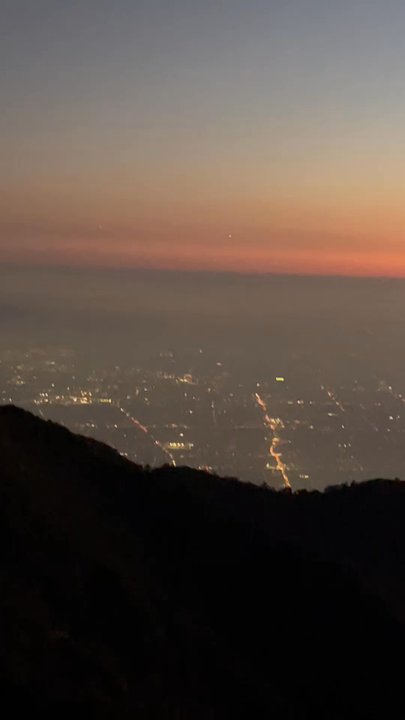
Scenic Night View in Sierra Madre, California
Waterfall Hike in Sierra Madre, California
Snow Park in Sierra Madre, California
Swimming Holes in Sierra Madre, California
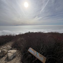
Lookout Points in Sierra Madre, California
Running Trails in Sierra Madre, California
Cliff Jumping in Sierra Madre, California
Walking Trails in Sierra Madre, California
Creeks in Sierra Madre, California
Hiking Groups in Sierra Madre, California
Scenic Overlook in Sierra Madre, California
Skyline View in Sierra Madre, California
Scenic Drives in Sierra Madre, California
Watch Sunset in Sierra Madre, California
Redwood Forest in Sierra Madre, California
Easy Hikes in Sierra Madre, California
Stairs Workout in Sierra Madre, California
Campgrounds in Sierra Madre, California
Flats in Sierra Madre, California
Trending Searches in Sierra Madre, CA
Baseball Fields near Mt. Wilson Trail
Boat Rental near Mt. Wilson Trail
Botanical Gardens near Mt. Wilson Trail
Bounce House Rentals near Mt. Wilson Trail
Campgrounds near Mt. Wilson Trail
Cherry Picking near Mt. Wilson Trail
Cliff Jumping near Mt. Wilson Trail
Dog Friendly Things To Do near Mt. Wilson Trail
Fishing Lake near Mt. Wilson Trail
Flower Fields near Mt. Wilson Trail
Flower Shop near Mt. Wilson Trail
Garage Sales near Mt. Wilson Trail
Lakes & Ponds near Mt. Wilson Trail
Nurseries & Gardening near Mt. Wilson Trail
Off Leash Dog Parks near Mt. Wilson Trail
Outdoor Activities near Mt. Wilson Trail
Outdoor Basketball Courts near Mt. Wilson Trail
Outdoor Furniture Stores near Mt. Wilson Trail
Party Equipment Rentals near Mt. Wilson Trail
Pedicure near Mt. Wilson Trail
Pick Your Own Farms near Mt. Wilson Trail
Picnic Areas near Mt. Wilson Trail
Picnic Spots near Mt. Wilson Trail
Places To Take Pictures near Mt. Wilson Trail
Plant Nursery near Mt. Wilson Trail
Public Beaches near Mt. Wilson Trail
Rock Quarry near Mt. Wilson Trail
Running Trails near Mt. Wilson Trail
Scenic Drive near Mt. Wilson Trail
Secret Spots near Mt. Wilson Trail
Splash Pad near Mt. Wilson Trail
Strawberry Picking near Mt. Wilson Trail
Sunrise View near Mt. Wilson Trail
Swimming Holes near Mt. Wilson Trail
Tennis Courts near Mt. Wilson Trail
Browse Nearby
BEST of Sierra Madre, California Coffee near Mt. Wilson Trail
BEST of Sierra Madre, California Things to Do near Mt. Wilson Trail
BEST of Sierra Madre, California Playgrounds near Mt. Wilson Trail
BEST of Sierra Madre, California Restaurants near Mt. Wilson Trail
BEST of Sierra Madre, California Picnic Areas near Mt. Wilson Trail
BEST of Sierra Madre, California Breakfast near Mt. Wilson Trail
BEST of Sierra Madre, California Campgrounds near Mt. Wilson Trail
BEST of Sierra Madre, California Glamping near Mt. Wilson Trail
BEST of Sierra Madre, California Motel near Mt. Wilson Trail
Browse Brands
Related Searches in Sierra Madre, CA
Best Fishing Locations and Guides in Sierra Madre, California
Best Nature Trails for Hiking in Sierra Madre, California
Best Off Leash Dog Parks in Sierra Madre, California
Best Parks for Parties and Events in Sierra Madre, California
Best Places for Horseback Riding in Sierra Madre, California
Best Water Parks for Kids in Sierra Madre, California
Best Waterfalls and Swimming Holes in Sierra Madre, California
Check Out Great Playgrounds in Sierra Madre, California
Check Out Off Road Trails in Sierra Madre, California
Discover Baseball Fields Around Sierra Madre, California
Discover Beautiful Garden Spots in Sierra Madre, California
Discover Dog Friendly Trails to Explore in Sierra Madre, California
Discover Fun Toddler Parks in Sierra Madre, California for Your Little One
Discover Kid Friendly Hiking Trails in Sierra Madre, California
Discover Lakes & Ponds to Explore in Sierra Madre, California
Discover Popular Photo Spots in Sierra Madre, California
Discover Scenic Bike Paths in Sierra Madre, California
Discover Scenic Hiking Trails in Sierra Madre, California
Discover Scenic Mountain Bike Trails Near Sierra Madre, California
Discover Scenic Waterfall Spots in Sierra Madre, California
Discover Soccer Fields in Sierra Madre, California Near You
Discover Top Nature Parks to Visit in Sierra Madre, California
Discover Top State Parks to Visit in Sierra Madre, California
Discover Walking Parks in Sierra Madre, California Near You
Discover a Hiking Trail in Sierra Madre, California
Discover the Best Beaches in Sierra Madre, California
Discover the Best Kids Park Spots in Sierra Madre, California
Discover the Best Night Hike Trails in Sierra Madre, California
Discover the Best Running Track in Sierra Madre, California
Dog-Friendly Hikes With Dogs in Sierra Madre, California
Enjoy Camping Adventures Around Sierra Madre, California
Enjoy Exciting Mountain Biking Adventures in Sierra Madre, California
Enjoy Kayaking Adventures in Sierra Madre, California
Enjoy Tent Camping Spots Around Sierra Madre, California
Enjoy a Beautiful Waterfall Hike in Sierra Madre, California
Enjoy a Peaceful Nature Walk in Sierra Madre, California
Enjoy the Best Picnic Spots and Ideas in Sierra Madre, California
Enjoy the Best Walking Path in Sierra Madre, California
Enjoy the Best Walking Trails in Sierra Madre, California
Exciting Cliff Jumping Spots in Sierra Madre, California
Explore Beautiful Parks and Green Spaces in Sierra Madre, California
Explore Easy Hikes Perfect for All in Sierra Madre, California
Explore Family-Friendly Zoos and Wildlife in Sierra Madre, California
Explore Free Picnic Areas Around Sierra Madre, California
Explore Fun Activities to Do in Sierra Madre, California
Explore Parks With Pull Up Bars in Sierra Madre, California
Explore Popular Campgrounds Near Sierra Madre, California
Explore Popular Picnic Areas Around Sierra Madre, California
Explore Popular RV Parks Around Sierra Madre, California
Explore Popular Recreation Centers Around Sierra Madre, California
Browse Articles
People who viewed Mt. Wilson Trail also viewed
Hoegee's Loop Trail
20 reviews
Bailey Canyon To Hastings Peak
54 reviews
Monrovia Canyon Park
329 reviews
Eaton Canyon Natural Area
1330 reviews
Mount Zion Trail
24 reviews
Ben Overturff Trail
24 reviews
Sturtevant Falls
717 reviews
Tad Williams Trail
7 reviews
Eaton Canyon Falls Trail
13 reviews
El Prieto Trail
28 reviews