Ben Overturff Trail Photos


You might also consider
More like Ben Overturff Trail
Recommended Reviews - Ben Overturff Trail
Start your review...

Reviews With Photos

Parking: 5 buckaroos to park here. The reason for this is because it's a private park, which closes at 5. If you want to pay nothing or cheap like me (asian), just park in the residential and treck up a mile and half before you reach to a sign that has a bear on it. From there you take the Ben Overturff Trail to get to your destination. 7 mile hike out and back! You can do it! Restrooms..... oh yeah, there are restrooms for you to use! If you want to be one with nature, you can tinkle and do your other stuff further into the forest. out of sight, out of mind. 3 months ago, I signed up with a meetup group that went on a hike to deer park, I came late, so I trecked this trail by myself and met them up at the deer park cabin. I thought the hike was beautiful and was a fairly easy hike. Kind of brought back memories of my boy scout days, going to camp trask. For the first part of the hike, you would have to share the fire road with the cars that are going in and out of camp trask. Usually on the weekends, there are boy scouts camping over night there. As you go further of the Ben Overturff trail, you see fewer people and eventually.... you'll be faced with nature itself. :) Eventually, you will see two pillars. This will give you a sign that the hike to deer park is going to be a single file hike through the forest. You'll meet switchbacks, but it's nothing to get scared of. Just going to be sore the next day. Recommend ya'll to come to this hike. When I have time, I'll go see the falls. I think it's only 3 miles out and back. Cheers and beeers ya'll!

This is the trail that is in the Monrovia Canyon Park. The troopers will charge you $5.oo to park. They make that pretty obvious all over the place. Honestly, are you here for a workout? Are you here to burn calories? They don't waste $5.00 to park your car. Just park on the bottom in the residential area and hike up. You can use that $5.00 on a treat afterward. Today, as I'm writing this review my calves are sore! I'm not too sure how long the hike was. When you hike up it's not a very hiker friendly trail. However when you get into Ben Overturff Trail there is a passage way for you to utilize. I would say this trail is man made. I say this because you don't have to really figure out how to hike it. There's signs and clear cut passages. Even when you cross the little water stream, you wont get wet if your feet is correctly on the big rocks. The trail is very relaxing however it's pretty much all uphill. so be prepared to be tired and out of breath! You'll get to see a small waterfall which is always worth it in the end of any trail. Near the waterfall there will be lots of bees. Not quite sure why. The passage uphill is narrow so make sure you share the passage because there will be people going down and up and you gotta get close to the hill or else you'll fall over and off the cliff. The park closes at 5pm. Make sure you wear appropriate hiking gear. There's about 2 bathrooms on the trail. Bring plenty of water because hiking up is going to be a thirst quencher!

Do NOT hike this trail alone. Several miles in, beyond the boy scout camp and police gun range, we lost all cell signal. Our hike became eerily quiet and completely desolate. If you're a chicken like me, you start to ruminate about finding a rotting body or being stalked by a bear. This hike is steep in many areas and an awesome workout, but I doubt I'd do it again. It starts as a boring concrete road, then becomes a wide dirt road with tire tracks. Later, the scenery improves a bit, but it's still mundane because you're in a canyon. You see, almost everyone who comes up to Monrovia Canyon takes the LEFT fork toward the falls. The 15 reviewers here and myself chose the RIGHT fork -- the road less traveled -- and ended up on a date with the ugly sister. BTW, we came across a big-ass semi-dried gift in the middle of the trail. I'm still learning the art of poop ID. After probing it with a stick to see if it contained berries, we concluded that it was either from a black bear or another hiker that saw a black bear.
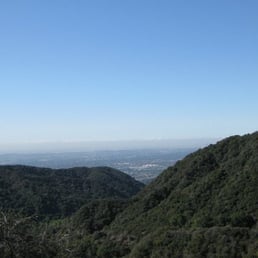
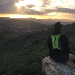
BEN OVER WHAT?!?!? Ben Overturff Trail BACKGROUND: Monrovia Canyon Park is an 80-acre wilderness park hosting great diversity inherent to this region, including riparian, oak woodland, and chaparrel ecosystems. The Ben Overturff Trail is named for a historical Monrovian who made these canyons and Deer Park a popular recreation area in the early 1900s. The reconstructed trail follows the original path as much as possible through Sawpit, Sycamore and Twin Springs canyons. It winds through approximately 3.5 miles of some of the most beautiful and undisturbed wilderness left in the San Gabriel mountains. STATS: DISTANCE: 3.5-7.5 miles ELEVATION: 2,000ft. FREE parking 1/2 walk from trail head PAID Parking $5.00 inside the park ESSENTIALS: Hiking shoes with good lug soles Water Layered clothing Hiking Poles Snacks Camera Sun screen Hat (optional) THE HIKE: From the park entrance station, the first half of the hike was up the Sawpit Fire Road to the Deer Park Trail Head. This is one of my favorite trail-ish hikes. While it's a lot of trail, along the way are pretty much destroyed structures, a stone cabin and a stable for the mules that were used to care food and supplies for campers. Unfortunately the cabin was purposely destroyed due to vandals. I find it most interesting when I come across what use to be. Imagining how people lived, what they did, tools that they used in their daily lives. Continuing on from the remnants of the cabin we were able to do some rock scrambling, where we pulled up a boulder and grubbed on snacks while engaging in idle chit chat. Then the trek up Deer Park Trail, a long, grueling uphill ascent on an exposed trail. Along the way we took moments out to take in the breathtaking views of the canyon below. All the greenery and signs of stream really makes one appreciate nature in all her glory. The return half of the trail passes thru riparian and woodland habitats. From there we hiked to Monrovia Canyon Waterfall, which was about an additional 2 miles round trip. Due to lack of rain, the waterfall was more of a trickle, but still magnificent. Since one can always turn back, this is hike ranges from beginner to advanced, where the beginner can hike to the stone cabin and the advanced can go all the way to the top of Deer Park. DISCLAIMER: Hiking is not something that can be taken lightly. It can be life-threatening as you see and hear on the news, people die or get lost all time. Please, if you are going to hike, never go alone and prepare for the worst, hope for the best. Remember when going for a hike, no matter how short you think it may be, always be prepared. Carry at least two liters of water for every five miles (more if the weather is warm), protein bar, nuts, and electrolytes. Wear sturdy lug sole shoes and protective clothing. Some areas the weather can change quicker than a fireman can put on his gear. It is also very important, always always always let a family member or friend know where you are going and when you expect to be back. Lastly, have fun when you hike it up. #HIKING #MONROVIA #BEGINNER #INTERMEDIATE #ADVANCED

which was a pretty moderate trail I would only say it's rough because it's a steep climb but really nice because the way up if you choose left is very sheltered and has very little sun and the way down was sunny but way more simple. when you arrive park and walk upwards there is a bear sign for the boy scout camp. go right where it's says authorized vehicles only. after walking up you will see yet another boy scout sign and then on the right a dirt path, take the dirt path and continue. at the top there is a closed gate and right on the left a pathway, take the pathway if you want a steep climb in shade going up or take the right side for a more sunny climb up but it isn't AS steep and rocky. beware of bugs and spiders, we did find some animal poop but no animal sightings other than birds and some cute lizards.

This hike is about 6.5-7 miles roundtrip, depending on the chosen route. I was not expecting that this would be a tough hike most of the way to the destination point. It is a great leg and butt workout, as it is steep much of the way there. Definitely go if you want a great lower body challenge! The start of the hike is on a paved fire road, completely exposed to the sun, and it is steep from the get-go. Once you've gone about 1 mile, you will see the sign and entrance for the Trask Boy Scout Camp. Look right and you will see an unshaded, wide, dirt trail going up (see photo). Take it. At the end of this part of the trail, you will have a choice to go through pilasters on a narrow path or straight past the gate on the same wide dirt road (see photo). If you want more intense climbing, take the narrow trail. It is deceiving, but it it pretty tough Most of the way is steep climbing. I really thought it would never end.... The trail is pretty through wooded trees and a stream and has dappled shade. The end point is Deer Park Cabin, which is not much to look at and is the site of cabin ruins. If you want a less strenous hike but still uphill, continue on the dirt road till you get to your destination. I took this way back - it's much less scenic and more exposed to the sun. But it saved my knees from going down that very steep climb. This choice is 0.4 miles longer than taking the steep hike. parking - there is a fee ($5 weekdays, $6 wknds and holidays). If you want to avoid the fee, then park in the residential area about 1/2 mile away and walk in. The walk will be in direct sun until you reach the trail. tip - this trail connects close to the starting point of the Monrovia Canyon Park waterfall trail, so you can warm up or cool down by hiking to/from the waterfall.

This is a nice trail, well maintained and a lot of great terrain. Continuously uphill from Monrovia Canyon Park to Deer Park Lodge, with a few steep sections that will make you sweat. Very scenic with a mix of lush riparian canyon forest and chapparral. A few city views, but this one is more about the hike itself than any particular overlook. Took the trail up and the fire road down. Saw maybe about 20 people on a Saturday, not solitude but not too crowded. Good trail, will be back. Dinging it one star because the first (and last) mile or so is on paved road. A lot of crazy drivers coming up and down, who don't care too much to look out for hikers. Had to keep the dog on a really short leash because of it. I wish Monrovia park service would find a way to build a trail from the park up to the Ben Overturff Trailhead, rather than making you go on paved road. Other than this one issue, it was a good trail.

Hiked the Ben Overturf trail today with my wife and two friends. About 7 miles round-trip..they closed the parking lot at 9am when we arrived due to the crowded holiday, so we had to park way down the street. The ranger notified us of a red bear sighting, and close to half-way up, a single female hiker passed us...and then came back towards us later looking frightened and alerted us that there was a bear ahead. She left, and we continued, making as much noise as possible. Later, near the (Twin Springs area, we came face to face with a "small" (bigger than us) reddish bear. We froze...it was on the other side of the trail, exactly where we had to walk. After what seemed like less than 20 seconds of it staring at us on all 4 legs, the bear turned and walked away. My friend grabbed a stick, and myself a couple rocks and waved my hat around, as we cautiously but noisily continued on to the deer cabin. From there the trail seemed to continue on, but then disappear, so we had to turn around and back track to the twin springs area where the trail goes three ways..which allowed us to exit to the road from there. Crazy hard hike on the legs... We will be sore tomorrow!

I've been using the AllTrails app for a new hike and it led me to this one. Although the waterfall was not what i expected (small stream) I enjoyed the hike. There was a lot of insects flying around it did get a little annoying but never the less made the trip horrible just every once in a while i would scare them of with my cap. I did end up hiking the truck trail which theres a circuit and lucky for me thats when all those flys went away and you literally find yourself in the mountain the trail goes along a river. Along the road i came across signs telling a description about the land, which i found pretty interesting. I did went up there with my dog so I was in a few occasions worried about any bears or mountain lions since we were the only ones on the trail, but didn't encounter any(sighs). Both trails, the water fall & truck trail was a total of 7 miles, good hike, i was glad their was hardly any graffiti and plenty off parking space, $5 on a weekday. Will be back soon, the dam looked cool, even though I'm afraid of heights. Hiking really has helped me with my anxiety and fears, wear your fav shoes/boots and start exploring!

i'm an avid hiker but this was a trail i had never heard about until last week thanks to the pasadena hiker pacers. there are so many great things about this trail and the first is the history behind it. this trail was designed when ben overtuff, a monrovia city contractor, leased the area now known as deer park around 1907. he built a lodge at deer park and used it as a tourist location. for 25 cents you could stay for a weekend that included food and lodge. unfortunately due to floods and ben's old age the lodge was left abandoned and after many years and misuse by vandals the lodge was disassembled. however some of the ruins still prevail to this day. the trail starts past the monvoria canyon park following the service road. about a mile uphill on the service road the trailhead appears. look for two small stone towers to the left of the road. from there it is about 3.5 miles of beautiful woods and river crossings. there are some good uphills to get your cardio going as well. very well kept and maintained trail. at the end of the 3.5 miles you come to deer park and the ben overtuff lodge ruins. excellent place to walk around and explore. from there you will see a sign that says restrooms. it is the same direction that will take you back to the service road you were once on and this service road will take you back to monrovia canyon park if you don't feel like going back the same way you came from. there are some exposed areas but overall you get good protection from the sun. keep an eye for snakes and ticks and most importantly, bring plenty of water! oh and don't forget your camera. enjoy!
2 years ago


Parking: 5 buckaroos to park here. The reason for this is because it's a private park, which closes at 5. If you want to pay nothing or cheap like me (asian), just park in the residential and treck up a mile and half before you reach to a sign that has a bear on it. From there you take the Ben Overturff Trail to get to your destination. 7 mile hike out and back! You can do it! Restrooms..... oh yeah, there are restrooms for you to use! If you want to be one with nature, you can tinkle and do your other stuff further into the forest. out of sight, out of mind. 3 months ago, I signed up with a meetup group that went on a hike to deer park, I came late, so I trecked this trail by myself and met them up at the deer park cabin. I thought the hike was beautiful and was a fairly easy hike. Kind of brought back memories of my boy scout days, going to camp trask. For the first part of the hike, you would have to share the fire road with the cars that are going in and out of camp trask. Usually on the weekends, there are boy scouts camping over night there. As you go further of the Ben Overturff trail, you see fewer people and eventually.... you'll be faced with nature itself. :) Eventually, you will see two pillars. This will give you a sign that the hike to deer park is going to be a single file hike through the forest. You'll meet switchbacks, but it's nothing to get scared of. Just going to be sore the next day. Recommend ya'll to come to this hike. When I have time, I'll go see the falls. I think it's only 3 miles out and back. Cheers and beeers ya'll! read more


This is the trail that is in the Monrovia Canyon Park. The troopers will charge you $5.oo to park. They make that pretty obvious all over the place. Honestly, are you here for a workout? Are you here to burn calories? They don't waste $5.00 to park your car. Just park on the bottom in the residential area and hike up. You can use that $5.00 on a treat afterward. Today, as I'm writing this review my calves are sore! I'm not too sure how long the hike was. When you hike up it's not a very hiker friendly trail. However when you get into Ben Overturff Trail there is a passage way for you to utilize. I would say this trail is man made. I say this because you don't have to really figure out how to hike it. There's signs and clear cut passages. Even when you cross the little water stream, you wont get wet if your feet is correctly on the big rocks. The trail is very relaxing however it's pretty much all uphill. so be prepared to be tired and out of breath! You'll get to see a small waterfall which is always worth it in the end of any trail. Near the waterfall there will be lots of bees. Not quite sure why. The passage uphill is narrow so make sure you share the passage because there will be people going down and up and you gotta get close to the hill or else you'll fall over and off the cliff. The park closes at 5pm. Make sure you wear appropriate hiking gear. There's about 2 bathrooms on the trail. Bring plenty of water because hiking up is going to be a thirst quencher! read more

8 years ago
Do NOT hike this trail alone. Several miles in, beyond the boy scout camp and police gun range, we lost all cell signal. Our hike became eerily quiet and completely desolate. If you're a chicken like me, you start to ruminate about finding a rotting body or being stalked by a bear. This hike is steep in many areas and an awesome workout, but I doubt I'd do it again. It starts as a boring concrete road, then becomes a wide dirt road with tire tracks. Later, the scenery improves a bit, but it's still mundane because you're in a canyon. You see, almost everyone who comes up to Monrovia Canyon takes the LEFT fork toward the falls. The 15 reviewers here and myself chose the RIGHT fork -- the road less traveled -- and ended up on a date with the ugly sister. BTW, we came across a big-ass semi-dried gift in the middle of the trail. I'm still learning the art of poop ID. After probing it with a stick to see if it contained berries, we concluded that it was either from a black bear or another hiker that saw a black bear. read more


12 years ago
BEN OVER WHAT?!?!? Ben Overturff Trail BACKGROUND: Monrovia Canyon Park is an 80-acre wilderness park hosting great diversity inherent to this region, including riparian, oak woodland, and chaparrel ecosystems. The Ben Overturff Trail is named for a historical Monrovian who made these canyons and Deer Park a popular recreation area in the early 1900s. The reconstructed trail follows the original path as much as possible through Sawpit, Sycamore and Twin Springs canyons. It winds through approximately 3.5 miles of some of the most beautiful and undisturbed wilderness left in the San Gabriel mountains. STATS: DISTANCE: 3.5-7.5 miles ELEVATION: 2,000ft. FREE parking 1/2 walk from trail head PAID Parking $5.00 inside the park ESSENTIALS: Hiking shoes with good lug soles Water Layered clothing Hiking Poles Snacks Camera Sun screen Hat (optional) THE HIKE: From the park entrance station, the first half of the hike was up the Sawpit Fire Road to the Deer Park Trail Head. This is one of my favorite trail-ish hikes. While it's a lot of trail, along the way are pretty much destroyed structures, a stone cabin and a stable for the mules that were used to care food and supplies for campers. Unfortunately the cabin was purposely destroyed due to vandals. I find it most interesting when I come across what use to be. Imagining how people lived, what they did, tools that they used in their daily lives. Continuing on from the remnants of the cabin we were able to do some rock scrambling, where we pulled up a boulder and grubbed on snacks while engaging in idle chit chat. Then the trek up Deer Park Trail, a long, grueling uphill ascent on an exposed trail. Along the way we took moments out to take in the breathtaking views of the canyon below. All the greenery and signs of stream really makes one appreciate nature in all her glory. The return half of the trail passes thru riparian and woodland habitats. From there we hiked to Monrovia Canyon Waterfall, which was about an additional 2 miles round trip. Due to lack of rain, the waterfall was more of a trickle, but still magnificent. Since one can always turn back, this is hike ranges from beginner to advanced, where the beginner can hike to the stone cabin and the advanced can go all the way to the top of Deer Park. DISCLAIMER: Hiking is not something that can be taken lightly. It can be life-threatening as you see and hear on the news, people die or get lost all time. Please, if you are going to hike, never go alone and prepare for the worst, hope for the best. Remember when going for a hike, no matter how short you think it may be, always be prepared. Carry at least two liters of water for every five miles (more if the weather is warm), protein bar, nuts, and electrolytes. Wear sturdy lug sole shoes and protective clothing. Some areas the weather can change quicker than a fireman can put on his gear. It is also very important, always always always let a family member or friend know where you are going and when you expect to be back. Lastly, have fun when you hike it up. #HIKING #MONROVIA #BEGINNER #INTERMEDIATE #ADVANCED read more


7 years ago
which was a pretty moderate trail I would only say it's rough because it's a steep climb but really nice because the way up if you choose left is very sheltered and has very little sun and the way down was sunny but way more simple. when you arrive park and walk upwards there is a bear sign for the boy scout camp. go right where it's says authorized vehicles only. after walking up you will see yet another boy scout sign and then on the right a dirt path, take the dirt path and continue. at the top there is a closed gate and right on the left a pathway, take the pathway if you want a steep climb in shade going up or take the right side for a more sunny climb up but it isn't AS steep and rocky. beware of bugs and spiders, we did find some animal poop but no animal sightings other than birds and some cute lizards. read more


12 years ago
This hike is about 6.5-7 miles roundtrip, depending on the chosen route. I was not expecting that this would be a tough hike most of the way to the destination point. It is a great leg and butt workout, as it is steep much of the way there. Definitely go if you want a great lower body challenge! The start of the hike is on a paved fire road, completely exposed to the sun, and it is steep from the get-go. Once you've gone about 1 mile, you will see the sign and entrance for the Trask Boy Scout Camp. Look right and you will see an unshaded, wide, dirt trail going up (see photo). Take it. At the end of this part of the trail, you will have a choice to go through pilasters on a narrow path or straight past the gate on the same wide dirt road (see photo). If you want more intense climbing, take the narrow trail. It is deceiving, but it it pretty tough Most of the way is steep climbing. I really thought it would never end.... The trail is pretty through wooded trees and a stream and has dappled shade. The end point is Deer Park Cabin, which is not much to look at and is the site of cabin ruins. If you want a less strenous hike but still uphill, continue on the dirt road till you get to your destination. I took this way back - it's much less scenic and more exposed to the sun. But it saved my knees from going down that very steep climb. This choice is 0.4 miles longer than taking the steep hike. parking - there is a fee ($5 weekdays, $6 wknds and holidays). If you want to avoid the fee, then park in the residential area about 1/2 mile away and walk in. The walk will be in direct sun until you reach the trail. tip - this trail connects close to the starting point of the Monrovia Canyon Park waterfall trail, so you can warm up or cool down by hiking to/from the waterfall. read more


15 years ago
This is a nice trail, well maintained and a lot of great terrain. Continuously uphill from Monrovia Canyon Park to Deer Park Lodge, with a few steep sections that will make you sweat. Very scenic with a mix of lush riparian canyon forest and chapparral. A few city views, but this one is more about the hike itself than any particular overlook. Took the trail up and the fire road down. Saw maybe about 20 people on a Saturday, not solitude but not too crowded. Good trail, will be back. Dinging it one star because the first (and last) mile or so is on paved road. A lot of crazy drivers coming up and down, who don't care too much to look out for hikers. Had to keep the dog on a really short leash because of it. I wish Monrovia park service would find a way to build a trail from the park up to the Ben Overturff Trailhead, rather than making you go on paved road. Other than this one issue, it was a good trail. read more


9 years ago
Hiked the Ben Overturf trail today with my wife and two friends. About 7 miles round-trip..they closed the parking lot at 9am when we arrived due to the crowded holiday, so we had to park way down the street. The ranger notified us of a red bear sighting, and close to half-way up, a single female hiker passed us...and then came back towards us later looking frightened and alerted us that there was a bear ahead. She left, and we continued, making as much noise as possible. Later, near the (Twin Springs area, we came face to face with a "small" (bigger than us) reddish bear. We froze...it was on the other side of the trail, exactly where we had to walk. After what seemed like less than 20 seconds of it staring at us on all 4 legs, the bear turned and walked away. My friend grabbed a stick, and myself a couple rocks and waved my hat around, as we cautiously but noisily continued on to the deer cabin. From there the trail seemed to continue on, but then disappear, so we had to turn around and back track to the twin springs area where the trail goes three ways..which allowed us to exit to the road from there. Crazy hard hike on the legs... We will be sore tomorrow! read more

7 years ago
I've been using the AllTrails app for a new hike and it led me to this one. Although the waterfall was not what i expected (small stream) I enjoyed the hike. There was a lot of insects flying around it did get a little annoying but never the less made the trip horrible just every once in a while i would scare them of with my cap. I did end up hiking the truck trail which theres a circuit and lucky for me thats when all those flys went away and you literally find yourself in the mountain the trail goes along a river. Along the road i came across signs telling a description about the land, which i found pretty interesting. I did went up there with my dog so I was in a few occasions worried about any bears or mountain lions since we were the only ones on the trail, but didn't encounter any(sighs). Both trails, the water fall & truck trail was a total of 7 miles, good hike, i was glad their was hardly any graffiti and plenty off parking space, $5 on a weekday. Will be back soon, the dam looked cool, even though I'm afraid of heights. Hiking really has helped me with my anxiety and fears, wear your fav shoes/boots and start exploring! read more


13 years ago
i'm an avid hiker but this was a trail i had never heard about until last week thanks to the pasadena hiker pacers. there are so many great things about this trail and the first is the history behind it. this trail was designed when ben overtuff, a monrovia city contractor, leased the area now known as deer park around 1907. he built a lodge at deer park and used it as a tourist location. for 25 cents you could stay for a weekend that included food and lodge. unfortunately due to floods and ben's old age the lodge was left abandoned and after many years and misuse by vandals the lodge was disassembled. however some of the ruins still prevail to this day. the trail starts past the monvoria canyon park following the service road. about a mile uphill on the service road the trailhead appears. look for two small stone towers to the left of the road. from there it is about 3.5 miles of beautiful woods and river crossings. there are some good uphills to get your cardio going as well. very well kept and maintained trail. at the end of the 3.5 miles you come to deer park and the ben overtuff lodge ruins. excellent place to walk around and explore. from there you will see a sign that says restrooms. it is the same direction that will take you back to the service road you were once on and this service road will take you back to monrovia canyon park if you don't feel like going back the same way you came from. there are some exposed areas but overall you get good protection from the sun. keep an eye for snakes and ticks and most importantly, bring plenty of water! oh and don't forget your camera. enjoy! read more


9 years ago
Great hike! But be prepared it is challenging if your are not used to going up steep hills. I wanna say that you have about 3-4min rest then steep hill again. Take lots of water and wear hiking boots! Be prepared for you will be hurting the next day! Great outdoor hike and you get a rewarding gorgeous view! read more

14 years ago
12 years ago
10 years ago
14 years ago
8 years ago
More info about Ben Overturff Trail
Ask the Community - Ben Overturff Trail
Review Highlights - Ben Overturff Trail
You might also consider


Why does Yelp recommend reviews?
2 reviews that are not currently recommended
The reviews below are not factored into the business's overall star rating.
14 years ago
12 years ago
Ben Overturff Trail - hiking - Updated June 2026
Best of Monrovia
People found Ben Overturff Trail by searching for…
Hiking Trails in Monrovia, California
Campgrounds in Monrovia, California
Abandoned Buildings in Monrovia, California
Waterfall Hike in Monrovia, California
Walking Trails in Monrovia, California
Scenic View in Monrovia, California
Beautiful Views in Monrovia, California
Running Trails in Monrovia, California
Easy Hikes in Monrovia, California
Hiking Trails Kid Friendly in Monrovia, California
Off Road Trails in Monrovia, California
Trails in Monrovia, California
Places to Walk at Night in Monrovia, California
Redwood Trees in Monrovia, California
Scenic Overlook in Monrovia, California
Secret Spots in Monrovia, California
Places to Take Photos in Monrovia, California
Dog Friendly Trails in Monrovia, California
Abandoned Places in Monrovia, California
Picnic Areas in Monrovia, California
Trending Searches in Monrovia, CA
Black Owned Nail Salons near Ben Overturff Trail
Boat Rental near Ben Overturff Trail
Cliff Jumping near Ben Overturff Trail
Day Trips near Ben Overturff Trail
Fishing Spots near Ben Overturff Trail
Jet Ski Rental near Ben Overturff Trail
Kayak Rental near Ben Overturff Trail
Lakes & Ponds near Ben Overturff Trail
Off Road Trails near Ben Overturff Trail
Outdoor Activities near Ben Overturff Trail
Places To Walk Around near Ben Overturff Trail
Public Shower near Ben Overturff Trail
River Swimming near Ben Overturff Trail
Rock Quarry near Ben Overturff Trail
Running Trails near Ben Overturff Trail
Scenic Night View near Ben Overturff Trail
Scenic Overlook near Ben Overturff Trail
Secluded Spots near Ben Overturff Trail
Soccer Store near Ben Overturff Trail
Splash Pad near Ben Overturff Trail
Strawberry Picking near Ben Overturff Trail
Sunrise View near Ben Overturff Trail
Swimming Holes near Ben Overturff Trail
Swimming Lakes near Ben Overturff Trail
U Pick Farms near Ben Overturff Trail
Watch Sunset near Ben Overturff Trail
Browse Articles
Browse Nearby
BEST of Monrovia, California Coffee near Ben Overturff Trail
BEST of Monrovia, California Things to Do near Ben Overturff Trail
BEST of Monrovia, California Walking Trails near Ben Overturff Trail
BEST of Monrovia, California Restaurants near Ben Overturff Trail
BEST of Monrovia, California Parks near Ben Overturff Trail
BEST of Monrovia, California Breakfast near Ben Overturff Trail
BEST of Monrovia, California Campgrounds near Ben Overturff Trail
Browse Brands
Related Searches in Monrovia, CA
Affordable Kayak Rental Services in Monrovia, California
Best Fishing Locations and Guides in Monrovia, California
Best Nature Trails for Hiking in Monrovia, California
Best Places for Horseback Riding in Monrovia, California
Check Out Off Road Trails in Monrovia, California
Discover Dog Friendly Trails to Explore in Monrovia, California
Discover Kid Friendly Hiking Trails in Monrovia, California
Discover Scenic Hiking Trails in Monrovia, California
Discover Scenic Mountain Bike Trails Near Monrovia, California
Discover Scenic Waterfall Spots in Monrovia, California
Discover Walking Parks in Monrovia, California Near You
Discover a Hiking Trail in Monrovia, California
Discover the Best Night Hike Trails in Monrovia, California
Discover the Best Running Track in Monrovia, California
Dog-Friendly Hikes With Dogs in Monrovia, California
Enjoy Camping Adventures Around Monrovia, California
Enjoy Exciting Mountain Biking Adventures in Monrovia, California
Enjoy Kayaking Adventures in Monrovia, California
Enjoy Tent Camping Spots Around Monrovia, California
Enjoy a Beautiful Waterfall Hike in Monrovia, California
Enjoy a Peaceful Nature Walk in Monrovia, California
Enjoy the Best Walking Path in Monrovia, California
Enjoy the Best Walking Trails in Monrovia, California
Exciting Cliff Jumping Spots in Monrovia, California
Explore Beautiful Parks and Green Spaces in Monrovia, California
Explore Easy Hikes Perfect for All in Monrovia, California
Explore Fun Activities to Do in Monrovia, California
Explore Popular Campgrounds Near Monrovia, California
Explore the Best Beach Spots in Monrovia, California
Explore the Best Trail Options in Monrovia, California
Family Friendly Hiking With Kids in Monrovia, California
Find Beautiful Views in Monrovia, California
Find the Best Parks for Picnics in Monrovia, California
Find the Best Scenic View Locations in Monrovia, California
Great Places to Walk in Monrovia, California
Hike the Popular Waterfall Trail in Monrovia, California
Hiking Trails With Waterfalls in Monrovia, California
Off Leash Dog Hiking Trails in Monrovia, California
Plan a Scenic Drive Route Near Monrovia, California
Popular Outdoor Activities to Try in Monrovia, California
Popular Picnic Spots to Visit in Monrovia, California
Safe River Swimming Areas in Monrovia, California
Safe and Fun Parks for Kids in Monrovia, California
Top Climbing Spots and Gyms in Monrovia, California
Top Paddleboarding Activities in Monrovia, California
Top Running Trails to Explore in Monrovia, California
Top Swimming Lakes to Enjoy in Monrovia, California
Top Swimming Spots and Pools in Monrovia, California
People who viewed Ben Overturff Trail also viewed
Santa Anita Canyon
84 reviews
Mt. Wilson Trail
303 reviews
Idlehour Trail Camp
5 reviews
Hermit Falls
298 reviews
Chantry Flat Recreation Area
276 reviews
Duarte Recreational Trail
36 reviews
Inspiration Point via Eaton Canyon
28 reviews
Jones Peak Loop Trail
4 reviews
San Gabriel Peak
10 reviews
Gabrielino Trail
81 reviews