Henninger Flats Campground Photos

 - Hiking Near Me - Altadena, California")


You might also consider
More like Henninger Flats Campground
Recommended Reviews - Henninger Flats Campground
Start your review...

Reviews With Photos

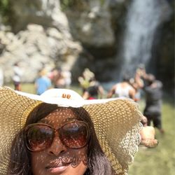
I went on the hike towards the waterfall. This is about 1.5 miles there and back, for a total of 3 miles. This trail is packed on the weekend! We were constantly backed up behind people, and literally every group had a dog. There are a lot of crossings over rocks/branches across streams, so wear shoes that you don't mind getting wet. I ended up giving up at one point and just walked through the streams bc it was easier than waiting for people to cross. The hike is relatively easy and flat, so no physical exertion. But it does require a lot of balance! Hahaha :) also, it's a nice trail w a good amount of trees, streams, and shade. There is one entrance w a parking lot. The Henninger opening doesn't have a parking lot, but there's plenty of parking around the neighborhood!

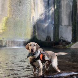
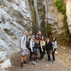
Came to this campsite last night with the wife and dog. It was a great hike/overnight camp to say the least! We had a blast but we also suffered a little because we didn't pack as warm as we should have. Things to know: 1. You can sleep up there overnight if you want. But whatever gear you bring you have to carry and hike with it all on your back: tent, backpacks, food, water, etc... 2. There are 3 levels to camp up there once you arrive: the lower which is the biggest and has a great view of the city, the middle level which has an even better view but limited camp sites, and finally the high level called Fugi which has only a few spots up there to camp. But it is the most secluded and private. We saw a couple up there on one of the two sleep areas and didn't want to intrude so we just camped at to lower level which was great. It's all first come first serve. 3. We packed a tent and some warm clothes and plenty of food and water but didn't have ENOUGH warm sleeping gear and as a result we were freezing at night! There are no open campfire pits. Two people can only carry so much so we couldn't have lugged two regular sized sleeping bags in addition to all the other stuff we had. We should have packed some small mini sleeping bags. All we slept with at night was our jackets. Mistake. I slept one hour because I was so cold. Being higher don't underestimate the chill of the night. 4. Bring plenty of food and water if you go in the summer heat of day. It's a moderate hike in my opinion. I'm in pretty good shape but for the average person it could be a challenge. It's about 1 hr and half to 2 hours hours up if you go pretty steady and 45 min down non stop. The entire hike TO THE CAMPSITE is all uphill. If you are out of shape it'll be a challenge for you. My wife was huffing and puffing most of the way lol. There is zero shade on the trail midday. 5. There IS running spring water up there behind the outhouse. It comes out of a nozzle. Note: it's nasty behind the outhouse with used toilet paper and feminine products there. But the nozzle is there. We drank it and we were fine. The locals up there drink it as well. If you have a dog he or she can definitely drink it as well. If your paranoid just boil it. But we drank it and we're ok. 6. You have to park on the street down the road where there are no restricted parking signs. There is restricted parking on the weekdays and weekends near the trail entrance. So park on a street where there is no restricted parking. Don't park overnight at Eaton Canyon parking lot. You'll get towed or cited. 7. You have to check in when you arrive if you want to camp overnight. It's free! No fee! There's a small museum there. 8. At night it is literally a ghost town since there is nobody up there except you and whatever other campers are there. The park ranger is there in the building overnight and if there is an emergency you can push the emergency button next to the entrance door. 9. There is a lot of wildlife there. Gotta watch out for snakes which we didn't see. They did tell us there are a few bears that have become familiar with the campsite. They are just looking for food. So use the near boxes. We heard some ruffling in the bushes at night. Not sure what it was. Could have been the deer we saw. Overall we like Henninger Flats! Great hiking trail and campsite to sleep overnight. Definitely recommend it. If I lived close to there I would hike it 3 or 4 times a week. It's a great workout! Not sure how accurate my FitBit really is but it said we took about 14,000 steps and burned about 1600 calories.
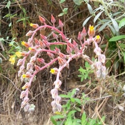
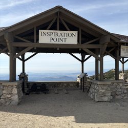
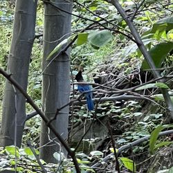
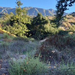
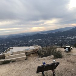
As far back as I can remember, my dad would take me and my five younger brothers on this hike from Pinecrest Dr. in Altadena up to Henninger Flats. There are actually several entry points to Eaton Canyon to access the fire road trail, but the most direct route is parking up off Crescent and Pinecrest, walking through the formidable gate (which is locked at sundown), cross the white bridge, and up you go for about 2.5 miles. The trail is wide enough to allow forest service and fire vehicles to drive up the dirt road, but for the most part it's only foot traffic. This is a popular hiking and running trail for us stupid hill runner folk, and while the path itself is easy to navigate, there are a couple of good incline switchbacks on the steady climb. Chaparral of sage, yucca, buckwheat, tree tobacco, mule fat, witch's hair, ironwood, wild mustard, and several wildflowers paint the landscape, especially in the spring. Fence lizards, gopher snakes, rattlesnakes, western racers, and the occasional coyote or deer can be seen along with several bird species like hawks, ravens, turkey vultures, and finches. At the top, hikers are welcomed by a shady forested area with many pine trees. Picnic facilities, restrooms, and a nature center (with a soda machine... Bring quarters!) are there. The view of LA and Southern California is outstanding on clear days, with Palos Verdes peninsula and Catalina island visible. If you're feeling energetic, you can continue up the trail in several directions: upper Henninger is another few miles. A left turn across a nondescript footbridge about a mile above Henninger takes you to Idlehour campground... Which is a peaceful and secluded camping area in upper Eaton Canyon, inaccessible from the lower canyon below the waterfall. Trails from Idlehour can take you up to Inspiration Point, and connect down Castle Canyon or Sam Merrill trail all the way to Lake Ave (a 19 mile loop to your car on Pinecrest!) If you stay on the main Henninger trail long enough, it goes all the way to Mount Wilson. Lots of options! Take care to watch your little hikers near the edge-- The San Gabriels are relatively some of the steepest mountains around! If you're tired of the crowds and noise of the waterfall hike, turn right and head uphill to discover a different kind of peace and quiet, just steps away from town.

Date of the hike: 5.1.2011 When our original plan to hike the Ben Overturff Trail was diverted because some maniac murder suspect was on the loose, we came here from a friend's suggestion. He assured us we would be out of harm's way. Compared to other hikes I've done recently (Echo Mountain, Bailey Canyon, and Boney Mountain) this hike was easier. Although there were a few steep parts but I think anyone could handle it. We started around 8AM and the sun was already pretty warm. When part of the mountain was shaded, it was pretty chilly. Other than that the mountain has no shade. I liked that there were several random benches along the trail for people to rest. When we reached the campground it was very shaded with tons of trees and benches. My friend and I actually got a little chilly and had to put a layer back on. We were lucky to hike on such a clear day! I was so amazed that there was no smog or cloud in sight. We were able to see Catalina Island from the top. The trail was about 6 miles round trip with 1400ft elevation gain/loss. It took my friends and I a little over two hours to complete the hike. Parking is limited in the residential area. We parked on the corner of Bowring Dr. and Pinecrest Dr. As always, get there early!


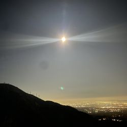
Just came back from an overnight at Henninger Flats Campground. The boyfriend and I packed our day packs up with our gear and traversed the 3mi hike to get to camp to join some friends. It was my first time backpacking and although the inclines aren't too challenging, the 15+ lbs packs we had made a difference. We were also carrying a gallon of water which made it all the more challenging. Some tips: ** Pack water - there is no longer running water up there, I'm guessing it's because of the drought ** Layer up - at 2000+ elevation, it gets mighty cold at night ** The camp provides wood for fires, and each site has an oven where you can cook/table to prepare your meal. ** Be prepared for very basic (not so clean) restrooms - hey, can't always be spoiled with running water/spotless restrooms when camping, right? ** Park a block or so from the trailhead. Don't make the same mistake we did and park downhill from the trailhead vs. uphill from it. The hike was completely worth it. We were lucky enough to snag the campsite that was right by the view of the SGV/Greater Los Angeles Area. We were lucky enough to come when it was overcast/cold, so we didn't have a problem with bugs or rattlesnakes, though we did see a couple of frogs. Our group hung a couple of hammocks up and enjoyed the quick getaway/backdrop of city lights into the night. Henninger Flats gets four "knopes" (ala my 'Parks and Rec' list) in my book.

2302 Crescent Dr. Altadena, CA 91001 This is the approximate address where I parked before walking down Pinecrest Dr. to the beginning of the Mt. Wilson Toll Road that leads up to Henninger Flats instead of starting from the Eaton Canyon Nature Center. Just be wary of signs that don't allow any parking on the weekends. The hike itself is one long fire road without any cover so remember your sunscreen and hat since the sun can get pretty intense. It's a constant incline all the way to the top so I got a good workout from the trek. This is a very easy, manageable hike for anyone! You get some really cool views of the Altadena and Pasadena area and it's pretty easy to make out Downtown LA in the far distance. I did not expect to find people camping up at the top and it seems like a great spot to get away from the busyness of LA! Last tip: The gate for the fire road gets locked after sundown and my friend told me she had to climb through a hole in the fence one time when she got locked in. Just watch out for the sunlight, otherwise you might have to end up doing the same!

Nice beginner destination for a backpacking trip. Likes: + Great view of Altadena/Pasadena and the LA county. Maybe you can spot Catalina or the Disney fireworks at night in the distance. + Pleasant getaway from town. Quiet, peaceful nature ambience. + A couple firepits for roasting your food with friends. + Great Mt Wilson with access to the giant 60-inch and the 100-inch Hooker telescopes. A hike you can do in a day. A camping/backpacking trip you can do in day & night. + Trails are wide and well defined. Non-likes: - The water spigot here runs extremely slow. I recommend packing your own extra water. - Restrooms running low on toilet paper. - Cosmic Cafe only open Apr-Sept 10am-5pm, and 10-4pm late Sept-Nov. If you walk farther uphill about 1-2 min, you'll find the white lavatory. Restroom stalls are more spacious than the auburn one. The water fountain and the water spigot there run fine and strong. read more


What goes up, must come down. This hike was a moderate 3 mile hike up and around the San Gabriel Mountains, but so much easier to trek back down. Although we did an extra mile after missing the turn and ended up hiking a total of 7 miles; it wasn't too bad. I only hike about once a month, so I took a few breaks along the way up so it took us about 3 hours roundtrip. The hike starts at the Eaton Canyon Nature Reserve after parking on the street along Altadena. There's parking in a lot as well but I find it easier to park on the street than finding a spot during peak hours. We started the hike by following the Eaton Canyon Falls trail, then veered onto the Walnut Canyon trail, and then followed the Old Mount Wilson Toll Road the rest of the way to the campground. There's some shade on the hike but not much so I wouldn't hike this during the Summer. We did this on 12/2/18 in 64 degree weather and it was perfect. We saw some people that did a one night backpacking trip so it's an ideal spot to practice for longer trips. There are bathrooms but they were locked when we were there and there is no water. There are also lots of tables available so pack a picnic and enjoy the view. Directions I used. If you see a white bridge on your way back, you missed the turn like I did and just did an extra mile. https://modernhiker.com/hike/henninger-flats/ read more


Henninger Flats Campground is located in Altadena up in the San Gabriel Mountains. Elevation is 2,600 feet above sea level. The only way to get up to the campgrounds is to hike it up. Our family (Team R) decided to backpack up to Henninger Flats on Saturday, October 6, at 5:30 a.m. to guarantee a first come first serve free campsite and campout until Sunday. The hike is a moderate three mile hike uphill with no shade. The plus is that a long the way up you will find four benches in which you can sit and enjoy the views of the city of Altadena and nearby cities. We were so fortunate to find a lot of campsites upon arrival. Henninger Flats has three campgrounds. The first is lower campground, which is were we camped at. The second is upper campground and the third is Fuji campground. It does not have running or potable water so you must bring enough water especially if you plan on hiking or camping out. We were blessed to get the campsite we wanted. We were a group of 12 so we were able to get campsite one and campsite two. We made sure to check in with the ranger/fire fighter on site at the visitor center/museum. I purchased one of the patches to commemorate the completion of the mini backpacking trip to and from Henninger Flats. My only regret is that it took me so long to come up here but finally I am able to mark off this wonderful place. read more


I went on the hike towards the waterfall. This is about 1.5 miles there and back, for a total of 3 miles. This trail is packed on the weekend! We were constantly backed up behind people, and literally every group had a dog. There are a lot of crossings over rocks/branches across streams, so wear shoes that you don't mind getting wet. I ended up giving up at one point and just walked through the streams bc it was easier than waiting for people to cross. The hike is relatively easy and flat, so no physical exertion. But it does require a lot of balance! Hahaha :) also, it's a nice trail w a good amount of trees, streams, and shade. There is one entrance w a parking lot. The Henninger opening doesn't have a parking lot, but there's plenty of parking around the neighborhood! read more


 - Hiking Near Me - Altadena, California")

4 years ago
7 years ago
3 years ago
9 years ago
Came to this campsite last night with the wife and dog. It was a great hike/overnight camp to say the least! We had a blast but we also suffered a little because we didn't pack as warm as we should have. Things to know: 1. You can sleep up there overnight if you want. But whatever gear you bring you have to carry and hike with it all on your back: tent, backpacks, food, water, etc... 2. There are 3 levels to camp up there once you arrive: the lower which is the biggest and has a great view of the city, the middle level which has an even better view but limited camp sites, and finally the high level called Fugi which has only a few spots up there to camp. But it is the most secluded and private. We saw a couple up there on one of the two sleep areas and didn't want to intrude so we just camped at to lower level which was great. It's all first come first serve. 3. We packed a tent and some warm clothes and plenty of food and water but didn't have ENOUGH warm sleeping gear and as a result we were freezing at night! There are no open campfire pits. Two people can only carry so much so we couldn't have lugged two regular sized sleeping bags in addition to all the other stuff we had. We should have packed some small mini sleeping bags. All we slept with at night was our jackets. Mistake. I slept one hour because I was so cold. Being higher don't underestimate the chill of the night. 4. Bring plenty of food and water if you go in the summer heat of day. It's a moderate hike in my opinion. I'm in pretty good shape but for the average person it could be a challenge. It's about 1 hr and half to 2 hours hours up if you go pretty steady and 45 min down non stop. The entire hike TO THE CAMPSITE is all uphill. If you are out of shape it'll be a challenge for you. My wife was huffing and puffing most of the way lol. There is zero shade on the trail midday. 5. There IS running spring water up there behind the outhouse. It comes out of a nozzle. Note: it's nasty behind the outhouse with used toilet paper and feminine products there. But the nozzle is there. We drank it and we were fine. The locals up there drink it as well. If you have a dog he or she can definitely drink it as well. If your paranoid just boil it. But we drank it and we're ok. 6. You have to park on the street down the road where there are no restricted parking signs. There is restricted parking on the weekdays and weekends near the trail entrance. So park on a street where there is no restricted parking. Don't park overnight at Eaton Canyon parking lot. You'll get towed or cited. 7. You have to check in when you arrive if you want to camp overnight. It's free! No fee! There's a small museum there. 8. At night it is literally a ghost town since there is nobody up there except you and whatever other campers are there. The park ranger is there in the building overnight and if there is an emergency you can push the emergency button next to the entrance door. 9. There is a lot of wildlife there. Gotta watch out for snakes which we didn't see. They did tell us there are a few bears that have become familiar with the campsite. They are just looking for food. So use the near boxes. We heard some ruffling in the bushes at night. Not sure what it was. Could have been the deer we saw. Overall we like Henninger Flats! Great hiking trail and campsite to sleep overnight. Definitely recommend it. If I lived close to there I would hike it 3 or 4 times a week. It's a great workout! Not sure how accurate my FitBit really is but it said we took about 14,000 steps and burned about 1600 calories. read more


As far back as I can remember, my dad would take me and my five younger brothers on this hike from Pinecrest Dr. in Altadena up to Henninger Flats. There are actually several entry points to Eaton Canyon to access the fire road trail, but the most direct route is parking up off Crescent and Pinecrest, walking through the formidable gate (which is locked at sundown), cross the white bridge, and up you go for about 2.5 miles. The trail is wide enough to allow forest service and fire vehicles to drive up the dirt road, but for the most part it's only foot traffic. This is a popular hiking and running trail for us stupid hill runner folk, and while the path itself is easy to navigate, there are a couple of good incline switchbacks on the steady climb. Chaparral of sage, yucca, buckwheat, tree tobacco, mule fat, witch's hair, ironwood, wild mustard, and several wildflowers paint the landscape, especially in the spring. Fence lizards, gopher snakes, rattlesnakes, western racers, and the occasional coyote or deer can be seen along with several bird species like hawks, ravens, turkey vultures, and finches. At the top, hikers are welcomed by a shady forested area with many pine trees. Picnic facilities, restrooms, and a nature center (with a soda machine... Bring quarters!) are there. The view of LA and Southern California is outstanding on clear days, with Palos Verdes peninsula and Catalina island visible. If you're feeling energetic, you can continue up the trail in several directions: upper Henninger is another few miles. A left turn across a nondescript footbridge about a mile above Henninger takes you to Idlehour campground... Which is a peaceful and secluded camping area in upper Eaton Canyon, inaccessible from the lower canyon below the waterfall. Trails from Idlehour can take you up to Inspiration Point, and connect down Castle Canyon or Sam Merrill trail all the way to Lake Ave (a 19 mile loop to your car on Pinecrest!) If you stay on the main Henninger trail long enough, it goes all the way to Mount Wilson. Lots of options! Take care to watch your little hikers near the edge-- The San Gabriels are relatively some of the steepest mountains around! If you're tired of the crowds and noise of the waterfall hike, turn right and head uphill to discover a different kind of peace and quiet, just steps away from town. read more


Date of the hike: 5.1.2011 When our original plan to hike the Ben Overturff Trail was diverted because some maniac murder suspect was on the loose, we came here from a friend's suggestion. He assured us we would be out of harm's way. Compared to other hikes I've done recently (Echo Mountain, Bailey Canyon, and Boney Mountain) this hike was easier. Although there were a few steep parts but I think anyone could handle it. We started around 8AM and the sun was already pretty warm. When part of the mountain was shaded, it was pretty chilly. Other than that the mountain has no shade. I liked that there were several random benches along the trail for people to rest. When we reached the campground it was very shaded with tons of trees and benches. My friend and I actually got a little chilly and had to put a layer back on. We were lucky to hike on such a clear day! I was so amazed that there was no smog or cloud in sight. We were able to see Catalina Island from the top. The trail was about 6 miles round trip with 1400ft elevation gain/loss. It took my friends and I a little over two hours to complete the hike. Parking is limited in the residential area. We parked on the corner of Bowring Dr. and Pinecrest Dr. As always, get there early! read more


6 years ago
9 years ago
Went here for an overnight camp, it was so worth it. We will definitely come back here again. Loving the solitude!!! read more


7 years ago
11 years ago
Just came back from an overnight at Henninger Flats Campground. The boyfriend and I packed our day packs up with our gear and traversed the 3mi hike to get to camp to join some friends. It was my first time backpacking and although the inclines aren't too challenging, the 15+ lbs packs we had made a difference. We were also carrying a gallon of water which made it all the more challenging. Some tips: ** Pack water - there is no longer running water up there, I'm guessing it's because of the drought ** Layer up - at 2000+ elevation, it gets mighty cold at night ** The camp provides wood for fires, and each site has an oven where you can cook/table to prepare your meal. ** Be prepared for very basic (not so clean) restrooms - hey, can't always be spoiled with running water/spotless restrooms when camping, right? ** Park a block or so from the trailhead. Don't make the same mistake we did and park downhill from the trailhead vs. uphill from it. The hike was completely worth it. We were lucky enough to snag the campsite that was right by the view of the SGV/Greater Los Angeles Area. We were lucky enough to come when it was overcast/cold, so we didn't have a problem with bugs or rattlesnakes, though we did see a couple of frogs. Our group hung a couple of hammocks up and enjoyed the quick getaway/backdrop of city lights into the night. Henninger Flats gets four "knopes" (ala my 'Parks and Rec' list) in my book. read more


2302 Crescent Dr. Altadena, CA 91001 This is the approximate address where I parked before walking down Pinecrest Dr. to the beginning of the Mt. Wilson Toll Road that leads up to Henninger Flats instead of starting from the Eaton Canyon Nature Center. Just be wary of signs that don't allow any parking on the weekends. The hike itself is one long fire road without any cover so remember your sunscreen and hat since the sun can get pretty intense. It's a constant incline all the way to the top so I got a good workout from the trek. This is a very easy, manageable hike for anyone! You get some really cool views of the Altadena and Pasadena area and it's pretty easy to make out Downtown LA in the far distance. I did not expect to find people camping up at the top and it seems like a great spot to get away from the busyness of LA! Last tip: The gate for the fire road gets locked after sundown and my friend told me she had to climb through a hole in the fence one time when she got locked in. Just watch out for the sunlight, otherwise you might have to end up doing the same! read more


6 years ago
4 years ago
13 years ago
I Yelped Eaton Canyon because I heard so many wonderful things about this waterfall etc... When my friend and I got to Eaton Canyon we noticed how busy it was so we took the high road, literally. We did not go up the paved path, we hiked the big incline to Mt. Wilson. This hike is pretty much up all hill with a few stops along the way and benches for those that need the rest. Lots of bugs when you get up to Henniger Flats, lots and lots of bugs. We also saw two deer and a baby rattlesnake. The restrooms were out of order and the outhouses were absolutely disgusting. There is this little trail behind the fire watch command post where there are some great views and you might encounter some wildlife like we did. Happy Trails! read more

No shade on this trek and parking is best around the residential area surrounding the park Enter from the Easton canyon side for best access to the 2.5 m one way trail Good views (not as grand as echo mountain) but slightly easier than echo mountain as well read more


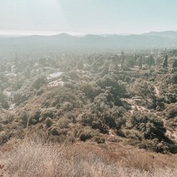
I love, love, love Henninger Flats. We did this hike in October and we started the hike around 5pm. We watched the sunset on the way up and made it to Henninger Flats right at dusk, then hiked down in the dark (DARK!)... and it was INCREDIBLE. I've been to Eaton Canyon countless times in the last couple of years and this last October was my first trip up to Henninger... I really don't know why we waited so long. The hike up is switch back after switch back with great views over the Valley, and on a clear day you can see the ocean. Every few switch backs there is a bench that you could take a little break on. It's 2.5 miles up and once you reach Henninger its a different world.. all of a sudden there are trees and a beautiful campground. There is running water and bathrooms! We didn't stay the night up there that night... Although there were some campers... we plan to go up soon and stay a night and hike up to Mt. Wilson the next day. For those that live in the Pasadena area.. if you look up near Mt Wilson and Eaton Canyon and you notice a patch of trees on a hill waaay up there... thats Henninger Flats! I had always wondered what was up there, mystery solved! More info here: http://www.simpsoncity.com/hiking/henninger.html read more


14 years ago
This trail is a great little work out, I've been here numerous times with friends although we always took the alternate path (the steep incline trail adjacent to the Roosevelt entrance called Walnut canyon). The trail is a continuous linear incline with a grade of around 20%~30% and significantly higher if you take the trail I mentioned earlier. If you plan on hiking this before or after hours I suggest you park on Roosevelt ave & N Altadena Dr. and go through the hole in the fence (literally). If you're going on normal hours or you just want a longer hike you can park on the Pinecrest Dr. entrance or at the Eaton Canyon Nature Center. There are basically two trailheads, the Pinecrest Dr. (bridge) and the Eaton canyon trail (follow the trail until you reach the bridge and there's a short trail to the right that leads up to the bridge) and then there's the aforementioned trail which is basically adjacent to the Roosevelt entrance. As someone else mentioned before there are 4 benches in total with the distance decreasing linearly. There is pretty much no shade on this trail so watch out if you're going to hike this during a sunny/hot day. There's not much to see on the trail itself but you get a nice view of the SGV and the river bed. Once you get to the top there's a little museum/nature center, restrooms, and water fountains. There's also a lot of trees but that's to expected from a tree nursery haha. read more


Started this hike around 1015 AM on a Cloudy Saturday from the Eaton Canyon Parking lot headed north. Soon, a creekbed appeared, which requires crossing at one point or another. After hiking another quarter mile on the right side of the creekbed, there is a spilt on the trail along with a sign indicating "Henniger Flats", but no arrow directing. After asking an elderly Korean lady, my group went left into the hill. The trial becomes very steep very quickly and is definitely strenuous for the average person. After several turns into the hill, one is greeted with some stunning views of the Pasadena area below. This steep trail continues for few more switchbacks/vista-points until it meets up with the Mt Wilson Toll Road. Mt Wilson Toll Road used to be a road for cars, so the path is wide and much less steep than the previous section. My group traversed to the campsite in quick fashion at this point, as the trail is very manageable. The Campground offers park benches for lunch, some bathrooms, views of the San Gabriel Valley, etc. There is a Fire Station there as well as a mini-museum, that has some historical artifacts. Even with breaks, it should not take longer than 1hr 40min from parking lot to Campground. The way down is a breeze as well, one can stop by Eaton Canyon waterfall to get a more complete experience. Overall, a fun intermediate hike, that is great for all levels of hiker, but the trail itself can get a bit boring after the initial steep part. read more

Review of the hike, not as much for the campground itself. I started from the Pinecrest gate instead of the Eaton Nature Center just to avoid the pointless walk on the Eaton Canyon Trail. Unfortunately, it looks like the neighbors dont like the weekend crowds because there is a restriction of NO PARKING ON WEEKENDS and 2 Hrs on WEEKDAYS. But you can drive up the street where the restriction ends I suppose. The hike is very similar to Echo Mountain on the Sam Merrill trail or Verdugo Mountain on the fire road. Very windy up the side of the mountain and well maintained fire road. After about half way, you can spot the patch of evergreen trees at the top, which seem FAR AWAY. Thankfully there are some benches, but on a sunny day, I'd rather find solace in the very few spots of shade behind a tall tree. The 2 mile marker is easy to miss, but even still, you got another 1/5 to go and is probably the hardest part. The view along the way is great, minus the smog of course. But once you FINALLY get to the top, its even more amazing. Crazy that there is a small pine forest 2600 feet over LA. The smell of the pine trees is so refreshing along with the gentle breeze. Very peaceful. There are multiple camping spots with picnic tables, and what I think are some grills. It looks like its open to camping, I so no restrictions other than no fires. The benches along the edge are a pleasure to sit and contemplate as you look down and see cars on the 210 march like ants. Took me 1:40 (with a lot of breaks) and almost an hour to walk back. I wish I had time to go and relax at Eaton Falls after, I would recommend that. read more


11 years ago
With this hiking trail, free, easily accessible to anyone in LA County---WHO NEEDS A GYM MEMEBRSHIP! I've been hiking this trail for many many times already, its just that this was the only time i have got the chance to pen down my review. amazing trail, absolutely challenging, especially is you run it to the top (You might need to go to a masseurs though after), and picturesque. way tooooooooo hot because its too out-in-the-open though, but who cares! smother yourself with an SPF 1000 read more

8 years ago
This hike was intense you are at an incline the whole way up... I'm amazed that I made it and didn't give up... I highly recommend going early like at 6am the sun gets too intense for me. read more


8 years ago
Heninger Flats was one of my favorite places to climb with my mountain bike. Why? Because it's safe to bike alone(there are always plenty of hikers). It is steep, (2,600 ft elevation) so the ascent is a bit of a workout. Since the last time I've been here though, i noticed the difference in the air quality. Hikers with dogs don't pick up their dog poop. It is all over the trail and it stinks!! I hope there is a clean-up group that would do aomething about this problem. Or at least put up a sign and dog pop bags the hikers can utilize.. read more


9 years ago
8 years ago
9 years ago
Page 1 of 3
More info about Henninger Flats Campground
2260 Pinecrest Dr
Altadena, CA 91001
Directions
(626) 794-0675
Call Now
Hours
Outdoor Amenities
Other Amenities
Ask the Community - Henninger Flats Campground
Hello! From what I am reading, the campsite is 3 miles away from the nearest place to park? Did anyone have issues finding a place to put their vehicle for the weekend? I assume you cannot drive up to drop things off either?
You cannot drive up to the Flats. There are certain streets that you can overnight park closer to the Eaton Canyon Bridge, which you'll be at the 3mile hike Mark. But you have to check the signs.… Read more
Review Highlights - Henninger Flats Campground
You might also consider


Why does Yelp recommend reviews?
Henninger Flats Campground - hiking - Updated July 2026
Best of Altadena
People found Henninger Flats Campground by searching for…
Free Campgrounds in Altadena, CA
Scenic Night View in Altadena, CA
Sleep in Your Car in Altadena, CA
View Fireworks in Altadena, CA
Lookout Points in Altadena, CA
Mineral Hot Springs in Altadena, CA
Waterfall Hike in Altadena, CA
River Swimming in Altadena, CA
Beautiful Views in Altadena, CA
Picnic Areas BBQ Pits in Altadena, CA
Camping Cabins in Altadena, CA
Secluded Spots in Altadena, CA
Trending Searches in Altadena, CA
Black Owned Nail Salons near Henninger Flats Campground
Boat Rental near Henninger Flats Campground
Cabins near Henninger Flats Campground
Cliff Jumping near Henninger Flats Campground
Crabbing Location near Henninger Flats Campground
Day Trips near Henninger Flats Campground
Dog Swimming near Henninger Flats Campground
Jet Ski Rental near Henninger Flats Campground
Kayak Rental near Henninger Flats Campground
Lakes near Henninger Flats Campground
Lakes & Ponds near Henninger Flats Campground
Long Term Rv Parking near Henninger Flats Campground
Nature Parks near Henninger Flats Campground
Off Road Trails near Henninger Flats Campground
Outdoor Activities near Henninger Flats Campground
Picnic Spots near Henninger Flats Campground
Places To Walk Around near Henninger Flats Campground
Public Pools near Henninger Flats Campground
Public Shower near Henninger Flats Campground
River Swimming near Henninger Flats Campground
River Tubing near Henninger Flats Campground
Rock Quarry near Henninger Flats Campground
Running Trails near Henninger Flats Campground
Rv Campgrounds near Henninger Flats Campground
Scenic Night View near Henninger Flats Campground
Scenic Overlook near Henninger Flats Campground
Soccer Store near Henninger Flats Campground
Splash Pad near Henninger Flats Campground
Sunrise View near Henninger Flats Campground
Swimming Holes near Henninger Flats Campground
Swimming Lakes near Henninger Flats Campground
U Pick Farms near Henninger Flats Campground
Watch Sunset near Henninger Flats Campground
Browse Articles
Browse Nearby
BEST of Altadena, California Coffee near Henninger Flats Campground
BEST of Altadena, California Things to Do near Henninger Flats Campground
BEST of Altadena, California Parks near Henninger Flats Campground
BEST of Altadena, California Restaurants near Henninger Flats Campground
BEST of Altadena, California Waterfalls near Henninger Flats Campground
BEST of Altadena, California Breakfast near Henninger Flats Campground
BEST of Altadena, California Campgrounds near Henninger Flats Campground
Browse Brands
Related Cost Guides
Related Searches in Altadena, CA
Affordable Long Term RV Parking in Altadena, California
Best Day Camps for Children in Altadena, California
Best Fishing Locations and Guides in Altadena, California
Best Nature Trails for Hiking in Altadena, California
Best Places for Horseback Riding in Altadena, California
Best Summer Camps for Kids Located in Altadena, California
Best Waterfalls and Swimming Holes in Altadena, California
Browse Charming Cabins in Altadena, California
Browse Top Hotels in Altadena, California for Your Stay
Browse Vacation Rentals to Book in Altadena, California
Check Out Off Road Trails in Altadena, California
Discover Dog Friendly Trails to Explore in Altadena, California
Discover Free Campgrounds in Altadena, California Area
Discover Fun Toddler Parks in Altadena, California for Your Little One
Discover Kid Friendly Hiking Trails in Altadena, California
Discover Lakes & Ponds to Explore in Altadena, California
Discover Scenic Beach Camping Sites in Altadena, California
Discover Scenic Hiking Trails in Altadena, California
Discover Scenic Mountain Bike Trails Near Altadena, California
Discover Scenic Waterfall Spots in Altadena, California
Discover Top Nature Parks to Visit in Altadena, California
Discover Top State Parks to Visit in Altadena, California
Discover Walking Parks in Altadena, California Near You
Discover a Hiking Trail in Altadena, California
Discover the Best Beaches in Altadena, California
Discover the Best Night Hike Trails in Altadena, California
Discover the Best Running Track in Altadena, California
Dog-Friendly Hikes With Dogs in Altadena, California
Enjoy Camping Adventures Around Altadena, California
Enjoy Exciting Mountain Biking Adventures in Altadena, California
Enjoy Hiking Adventures in Altadena, California
Enjoy Kayaking Adventures in Altadena, California
Enjoy RV Camping Adventures in Altadena, California
Enjoy Tent Camping Spots Around Altadena, California
Enjoy a Beautiful Waterfall Hike in Altadena, California
Enjoy a Peaceful Nature Walk in Altadena, California
Enjoy the Best Walking Path in Altadena, California
Enjoy the Best Walking Trails in Altadena, California
Exciting Cliff Jumping Spots in Altadena, California
Explore Beautiful Parks and Green Spaces in Altadena, California
Explore Easy Hikes Perfect for All in Altadena, California
Explore Fun Activities to Do in Altadena, California
Explore Mobile Home Parks in Altadena, California Now
Explore Popular Campgrounds Near Altadena, California
Explore Popular Picnic Areas Around Altadena, California
Explore Scenic Lakes to Visit in Altadena, California
Explore Summer Camps for All Ages in Altadena, California
Explore Top Dog Parks in Altadena, California Near You