Cooper Canyon Falls Photos


You might also consider
More like Cooper Canyon Falls
Recommended Reviews - Cooper Canyon Falls
Start your review...

Reviews With Photos

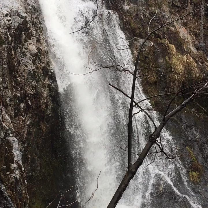
I think this is my new favorite waterfall hike in LA! The waterfall was lush and I'm always up for some rock scrambling, especially when it involves a little rope! We had to enter the campground to access the trailhead (restrooms were all closed when we went despite campers staying there) and parking by the Buckhorn Campgroung gate filled up pretty quickly by 8AM. AKA, try to arrive early to get a decent spot. You can also drive into the campground to park at the actual trailhead, but the designated exit may be blocked off without warning - which means you will have to drive backwards all the way back down on the narrow dirt road. Still, it's a great spot for a quick getaway into the mountains. Make sure to pack out your trash!


Beautiful hike. Slightly difficult to find if not familiar with area. We made the mistake of parking at beginning of buckhorn camp so we added about a mile to our trip each way. Once you see the waterfall from burkhart trail theres a mountain side to climb down. Theres ropes tied to assist but still slippery so be careful. The falls are stunning. Like out of Fern Gully lol. I recommend dipping in the water and taking a waterfall shower. Bring water shoes so you can keep your hiking shoes dry. You do descend down so be prepared to go back up.

Not a bad little waterfall hike that's smack dab in the middle of the Angeles National Forest. After postponing this hike since the winter (due to snow closures on the 2) I finally came out to check out the falls at Cooper Canyon this morning. The falls sit along the Pacific Crest Trail and you can get to the falls from a few places, namely Buckhorn Campground, Eagle's Roost, and where my comrades and I begun, which was Cloudburst Summit. From Cloudburst, it's an inside out hike for 3.5 miles to the falls one way. Meaning you start going downhill and come back going uphill instead of the typical climb a mountain and come back down. The way down was quite pleasant early in the morning, but we really felt the intense heat when we made our way back up in the late morning. There's pockets of shade on the trail, but even with the vast amount of tree's it was still pretty exposed to sun. It's easy to miss the waterfall itself, as there is small side trail that you need you take. This side trail is unmarked and a few hundred feet east of the junction of 2 trail signs at a junction - one leading to Cooper Canyon Campsite, the other Buckhorn Campground. The water down at the falls was clearest water that I've seen in SoCal, very picturesque stuff. I was glad to see that was actually running water over the falls, as I've seen a lot of dry ones in the summer months. I'd really like to get back here in the winter and see it when the water levels are higher. Overall, it was good hike that's not too taxing if you are willing to drive an hour deep into the Angeles National Forest.

Favorite waterfall hike to date. I haven't went recently but I've camped in Buckhorn Campgrounds my entire life with several groups of people over time, family, friends etc. The trail begins once you pass through the campground like other reviewers have mentioned. You do need an adventure pass, I recommend picking one up in La Canada Flintridge before driving up through the mountain to this trailhead. Make sure you also take sufficient amount of water & food because the drive back down is about 45 minutes. There's not much to say that others haven't, it's just one of those trails you have to see for yourself! I did this once at 8 months pregnant so I would say this trail is for everyone!

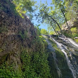
Best waterfall hike in the San Gabriels by far, but not without some caveats. The best time to go is late winter/early spring. This is when the falls are flowing best, however may be frozen if it's a little too cold. This is also gorgeous, but means scrambling down half frozen steep rocks. There is a rope, but be aware. ALSO, if you go during winter, or too early in spring, the campground road to the trail head parking is closed, which means you have to park about a mile from the trail head, adding about two miles to a four mile hike. Lastly, this is an upside down hike in that you begin by descending and have to climb out. All that said, you SHOULD go. The jeffery pines, small redwoods and cedars so close to L.A. make it worth every step.

This is such a LOVELY SERENE Trail! Meandering through the forest & enjoying the light scattering through the ginormous pines is soooo PEACEFUL! Beautiful wildflowers in the spring; Following the bubbling creek & playing on the stepping stones makes you feel like a kid again. The Hidden Waterfall is definitely a Treat. The LIFEFORCE was INTENSE & I left feeling ENERGIZED after a 14 mile hike! Note: the Hidden waterfall is definitely hidden, you could walk right past it & not even know, as we first did. I'm going to try explain this as the other reviews were difficult to get. This is from starting at the top side of the loop: head down the mountain several miles, at the fork proceed down the fire road along the creek and you will meet up with the trail that runs alongside the creek. At about the half way point in the loop when you cross the creek continue on until you see a sign for Buckhorn. Instead of turning right up the hill hang a left; someone wrote waterfall in black marker with an arrow. Head that direction for less than half a mile and the Hidden waterfall is on the left. There is an unambiguous path with a tree stump on the top bank. Head down the path & use the rope to descend. If you reach rattlesnake trail at the bottom of the hill from the main trail-you passed it. When you are satiated head back up the hill and follow signs to Buckhorn. After the trail there is a paved road that takes you through the campground and uphill to Hwy 2. You will hike about 1.5-2 Miles on 2 back up to the Trailhead. This portion of the hike is all uphill & has little shade.

Really loved this trail. We went just after the week of rain and snow in the mountains so we were walking on packed snow almost the whole trail. We walked from the road, through the Buckhorn campground to get to the Burkhart trailhead. That leads to the falls. If you're planning to go while theres still snow, make sure you suit up.

Recommended to bring: Adventure pass for parking Extra layer (it got cold on and off) Towel Shoes you're okay with getting wet You'll need to get inside Buckhorn Campgrounds first as Burkhart's Trail (the way to Cooper Canyon Falls) is located there and not whatever's pinpointed on Yelp. A quick peak at google maps could prevent you from making the same minor error I did of unnecessarily driving 2 additional miles down the road and to nothing at all. I arrived here at about 9:30 and the place was desolate. I'm not sure if it's empty because the campground is currently closed or maybe this is just a bit of a hidden gem that not too many people know about yet. I had to park inside the Buckhorn day use picnic area which is located about 1000 ft from the campgrounds. RT from the car was 6 miles and took me 3 hours to complete, but this is mostly due to me just dicking around and taking photos. The hike goes downhill practically the entire time in, but what goes down has to come up, so the way back is a tad of a bitch. It didn't prove to be too strenuous as I was able to get back up to the car within an hour without making any stops. So even at average health you shouldn't have a problem. You'll get shade on and off throughout the hike with only one part where you're directly blasted by the sun, but even lackadaisically walking through it would take you 3 minutes at most. Once you're down in the creek area you'll be encompassed by the foliage above. The trail features redwoods, pines, rock formations, fat squirrels and many points for photo opportunities. Eventually you'll hit a sign that tries to "Cheshire Cat" you out of finding the waterfall. The left points to Cooper Canyon Falls and the continuing path is Burkhart Trail. Follow that! The waterfall is not too far from the signage and a little further ahead on the left is a somewhat sketchy looking path down. That way will lead you to the base of the fall. Some good samaritan left their rope behind for ease of the descent. This trail is dog friendly, but unless you want to do the highly unethical method of tossing Fido to his demise you should probably leash him to a nearby tree before going down. I was lucky enough to have the whole waterfall to myself and had I packed a sandwich it would have been the perfect picnic. But there's always next time and I'm definitely coming back!

Cooper Canyon Falls Beautiful hike, about 3.5 miles RT. I've been hiking all over LA/OC area in the last several years and this is my favorite waterfall hike so far. Definitely worth the drive! It's about 36 miles along Hwy 2 ( Angeles Crest Hwy) from La Canada Flintridge. Once you pass Waterman Ski area on your right start looking for Buckhorn Campground on your left ( past the Buckhorn Day Use Area). Drive down to the very bottom of the campground until you see a sign for Buckhart Trail parking. Park there. You will need an Adventure Pass ( $5 day pass or $30 annual pass) which you must purchase ahead of time at REI, Sports Chalet...). There are pit toilets at the trailhead. The closest trash cans are the bear-proof ones up farther in the campground. We figured this out when at the trailhead we had a full doggie bag to dispose of. . The trail near the campground still had large patches of snow. The trail was well maintained and snow free throughout. The trail follows are river/stream throughout the hike and could be heard all along the trail. The trail descends slowly to the canyon. A bit rocky and narrow in places, but negotiable even when passing other hikers with our lab in tow. We meet few day hikers on Sunday afternoon, but we're delighted to pass about a dozen PCT through hikers as the PCT ( Pacific Crest Trail) intersects the Buckhart Trail twice in this stretch. There are beautiful giant Redwood and Ponderosa Pines scattered throughout the hike. Lupine and bright yellow monkey flower are now in bloom ( as well as along Hwy 2). You will descend into the canyon and pass over a small creek. A ways past the creek crossing you will see a sign for Cooper Canyon Camoground/PCT going left. Continue on the Burkhart Trail to the RIGHT. At the bottom of the sign someone has indicated waterfall with arrow to the right. Continue hiking along the creek and listen for Cooper Canyon Falls on the right down in the canyon. There is NO SIGN for the falls. Look for the steep and rather hidden trail PAST the falls ( there are some wood embankment walls built to prevent erosion where the trail starts down). The trail is steep, rocky, narrow and requires footwear with good tread. 50 ft or so down you will see a thick, secure cotton rope to help you descend the rest of the way into the canyon. There is good footing except for the last 10 feet which is rocky. The waterfall is beautiful and was freely flowing when we were there. If you don't want to go down in the rope there is a view of the falls near where the rope is secured. It's worth the view. We actually missed the falls the first time and continued to the next creek crossing, it was a nice place to have lunch. Just up the trail the narrow PCT trail picks up again on the right. If you get here you have gone too far. Once you visit the falls retrace your hike. This hike felt more challenging than its 3.5 miles. The elevation of 5,000 to 6,000 feet and the steady hike back out were probably the reason. This was the first time I tried hiking poles and I was very glad to have them on the hike out! I had read the elevation gain for this hike is around 800 feet which sounds about right. Take more food and water than you think you'll need. I had 3 L for me and our lab which was fine in early Spring. Bring your camera. There are plenty of photo ops along the trail. There is another, longer route ( 7+ mi) to the falls out of Cloudburst which you will pass on the way to Buckhorn Campgound. This is definitely on my bucket list. On Hwy 2 there is a resturant and a visitors center along the way. We didn't stop this time, but plan to on another visit. Enjoy!

It was a Sunday morning on easter day, came with my hiking crew. Theres 4 of us, all first time here. Let me first say that this hike is not easy by far, bring a lot of water. We started the trail at 9:30, its all down hill basically. No signs pointed to anywhere until you walked for at least 30 mins. We got to the water fall and Its not even a water fall, small stream basically. I ask one of my friend "this can't be it" I decided to keep going, we follow the buckhorn trail. My other friend stop following us by this time and decided to turn back with his girlfriend. Me and my other buddie kept going for about an hour. I decided we need a 10 min break and started eating beef jerky. At this point there was no sign of people what so ever, the air was thinner. I made the call to turn back, its a not good sign at the moment. Our stride got us back to the water fall "stream" in 30 mins. I was looking for my other friends but I figure they went back to the car. This is where the hard part begins, all incline all the way back up. Im a strong hiker and I work out 5 days a week but I had to make at least 6 stops before we got back to the car. Worst part my leg started cramping up. I was thinking in my head who the heck put down "easy moderate". When you get back to your car you will feel such a relief. All in all a lot of trees, a great exercise. If you want a challenge this is the place.
")
Welp. I did this hike on December 26th, 2014. I didn't actually make it to Cooper canyon falls because the snow and ice were crazy thick. Still it was amazing. It is a fairly easy hike out of Buckhorn campground that looks like your in the Sierra Nevada. This hike seems easy enough for kids, yet entertaining enough for even the most experienced of backpackers. My point of this review is mainly to add the awesome pictures I took that day. Enjoy!

We did the loop on 12/30/22. There were patches of ice and snow. I wore microspikes for about a 1/3 of the hike. We did the loop and the total mileage was 7 miles. The 2 people I did the hike with didn't have microspikes and they were fine. A lot of this area has been affected by the fires over the previous couple years. Since it is such a long, winding drive along Hwy 2 this trail is not very busy. Make sure to display your Adventure Pass parking permit. Because of the recent storms the waterfall had a good amount of water. read more


6 years ago
This is a beautiful short hike to a nice waterfall. If Buckhorn Campground is open, then you can park past the campground, it's about 3 miles round trip from here. But if the gate is closed to Buckhorn Campground, you will have to park outside and hike to the start of Burkhart trail head which will make this about 4 miles round trip. You will need to display an adventure pass for parking. There are restrooms in the campground area. When I hiked this, the campground was closed. I parked outside and follow the road into the campground. If you follow the road, there are signs directing you to Burkhart Trail. The hike itself is not hard, but pace yourself and enjoy everything around you. You can hear the stream running pretty much throughout the whole hike, but it might be seasonal pending on rain or snow. The trees are so big and majestic. It's definitely way different if you hike near Redbox Picnic area which is my go to destination. The trail is pretty straightforward, the only fork in the trail is when you see the posted sign to cooper canyon trail. Here you want to continue onto the Burkhart Trail. I would say about 50 to 100 feet past the posted sign, you will hear and see a large stream to your left. Keep an eye out for a rock scurry to the left to Cooper Canyon Falls. Someone tied ropes to help hikers climb down if you need it. Enjoy the waterfall and hike back out the way you came in. Whatever you bring in, take out. Don't be a jerk and litter this place. You want others to enjoy this place as clean and natural as it can be. Note, there is a small hidden side trail if you feel adventurous, it will take you to Buckhorn Falls:) As always, pack accordingly to the weather and have fun. read more


6 years ago
I think this is my new favorite waterfall hike in LA! The waterfall was lush and I'm always up for some rock scrambling, especially when it involves a little rope! We had to enter the campground to access the trailhead (restrooms were all closed when we went despite campers staying there) and parking by the Buckhorn Campgroung gate filled up pretty quickly by 8AM. AKA, try to arrive early to get a decent spot. You can also drive into the campground to park at the actual trailhead, but the designated exit may be blocked off without warning - which means you will have to drive backwards all the way back down on the narrow dirt road. Still, it's a great spot for a quick getaway into the mountains. Make sure to pack out your trash! read more

6 years ago
Easy hike to the water falls. Highly recommended! make sure to wear all weather/water proof hiking boots as sheets of ice are still on trail this time of the month have fun on your hike and stay hydrated read more


6 years ago
A wonderful place to go Hiking with the family we did a nice work out walking. We walk 6 miles to get to the fall but went you there is beautiful. read more


6 years ago
Beautiful hike. Slightly difficult to find if not familiar with area. We made the mistake of parking at beginning of buckhorn camp so we added about a mile to our trip each way. Once you see the waterfall from burkhart trail theres a mountain side to climb down. Theres ropes tied to assist but still slippery so be careful. The falls are stunning. Like out of Fern Gully lol. I recommend dipping in the water and taking a waterfall shower. Bring water shoes so you can keep your hiking shoes dry. You do descend down so be prepared to go back up. read more


Not a bad little waterfall hike that's smack dab in the middle of the Angeles National Forest. After postponing this hike since the winter (due to snow closures on the 2) I finally came out to check out the falls at Cooper Canyon this morning. The falls sit along the Pacific Crest Trail and you can get to the falls from a few places, namely Buckhorn Campground, Eagle's Roost, and where my comrades and I begun, which was Cloudburst Summit. From Cloudburst, it's an inside out hike for 3.5 miles to the falls one way. Meaning you start going downhill and come back going uphill instead of the typical climb a mountain and come back down. The way down was quite pleasant early in the morning, but we really felt the intense heat when we made our way back up in the late morning. There's pockets of shade on the trail, but even with the vast amount of tree's it was still pretty exposed to sun. It's easy to miss the waterfall itself, as there is small side trail that you need you take. This side trail is unmarked and a few hundred feet east of the junction of 2 trail signs at a junction - one leading to Cooper Canyon Campsite, the other Buckhorn Campground. The water down at the falls was clearest water that I've seen in SoCal, very picturesque stuff. I was glad to see that was actually running water over the falls, as I've seen a lot of dry ones in the summer months. I'd really like to get back here in the winter and see it when the water levels are higher. Overall, it was good hike that's not too taxing if you are willing to drive an hour deep into the Angeles National Forest. read more

9 years ago
Favorite waterfall hike to date. I haven't went recently but I've camped in Buckhorn Campgrounds my entire life with several groups of people over time, family, friends etc. The trail begins once you pass through the campground like other reviewers have mentioned. You do need an adventure pass, I recommend picking one up in La Canada Flintridge before driving up through the mountain to this trailhead. Make sure you also take sufficient amount of water & food because the drive back down is about 45 minutes. There's not much to say that others haven't, it's just one of those trails you have to see for yourself! I did this once at 8 months pregnant so I would say this trail is for everyone! read more


Best waterfall hike in the San Gabriels by far, but not without some caveats. The best time to go is late winter/early spring. This is when the falls are flowing best, however may be frozen if it's a little too cold. This is also gorgeous, but means scrambling down half frozen steep rocks. There is a rope, but be aware. ALSO, if you go during winter, or too early in spring, the campground road to the trail head parking is closed, which means you have to park about a mile from the trail head, adding about two miles to a four mile hike. Lastly, this is an upside down hike in that you begin by descending and have to climb out. All that said, you SHOULD go. The jeffery pines, small redwoods and cedars so close to L.A. make it worth every step. read more

8 years ago
8 years ago
This is such a LOVELY SERENE Trail! Meandering through the forest & enjoying the light scattering through the ginormous pines is soooo PEACEFUL! Beautiful wildflowers in the spring; Following the bubbling creek & playing on the stepping stones makes you feel like a kid again. The Hidden Waterfall is definitely a Treat. The LIFEFORCE was INTENSE & I left feeling ENERGIZED after a 14 mile hike! Note: the Hidden waterfall is definitely hidden, you could walk right past it & not even know, as we first did. I'm going to try explain this as the other reviews were difficult to get. This is from starting at the top side of the loop: head down the mountain several miles, at the fork proceed down the fire road along the creek and you will meet up with the trail that runs alongside the creek. At about the half way point in the loop when you cross the creek continue on until you see a sign for Buckhorn. Instead of turning right up the hill hang a left; someone wrote waterfall in black marker with an arrow. Head that direction for less than half a mile and the Hidden waterfall is on the left. There is an unambiguous path with a tree stump on the top bank. Head down the path & use the rope to descend. If you reach rattlesnake trail at the bottom of the hill from the main trail-you passed it. When you are satiated head back up the hill and follow signs to Buckhorn. After the trail there is a paved road that takes you through the campground and uphill to Hwy 2. You will hike about 1.5-2 Miles on 2 back up to the Trailhead. This portion of the hike is all uphill & has little shade. read more


7 years ago
Really loved this trail. We went just after the week of rain and snow in the mountains so we were walking on packed snow almost the whole trail. We walked from the road, through the Buckhorn campground to get to the Burkhart trailhead. That leads to the falls. If you're planning to go while theres still snow, make sure you suit up. read more


9 years ago
9 years ago
Recommended to bring: Adventure pass for parking Extra layer (it got cold on and off) Towel Shoes you're okay with getting wet You'll need to get inside Buckhorn Campgrounds first as Burkhart's Trail (the way to Cooper Canyon Falls) is located there and not whatever's pinpointed on Yelp. A quick peak at google maps could prevent you from making the same minor error I did of unnecessarily driving 2 additional miles down the road and to nothing at all. I arrived here at about 9:30 and the place was desolate. I'm not sure if it's empty because the campground is currently closed or maybe this is just a bit of a hidden gem that not too many people know about yet. I had to park inside the Buckhorn day use picnic area which is located about 1000 ft from the campgrounds. RT from the car was 6 miles and took me 3 hours to complete, but this is mostly due to me just dicking around and taking photos. The hike goes downhill practically the entire time in, but what goes down has to come up, so the way back is a tad of a bitch. It didn't prove to be too strenuous as I was able to get back up to the car within an hour without making any stops. So even at average health you shouldn't have a problem. You'll get shade on and off throughout the hike with only one part where you're directly blasted by the sun, but even lackadaisically walking through it would take you 3 minutes at most. Once you're down in the creek area you'll be encompassed by the foliage above. The trail features redwoods, pines, rock formations, fat squirrels and many points for photo opportunities. Eventually you'll hit a sign that tries to "Cheshire Cat" you out of finding the waterfall. The left points to Cooper Canyon Falls and the continuing path is Burkhart Trail. Follow that! The waterfall is not too far from the signage and a little further ahead on the left is a somewhat sketchy looking path down. That way will lead you to the base of the fall. Some good samaritan left their rope behind for ease of the descent. This trail is dog friendly, but unless you want to do the highly unethical method of tossing Fido to his demise you should probably leash him to a nearby tree before going down. I was lucky enough to have the whole waterfall to myself and had I packed a sandwich it would have been the perfect picnic. But there's always next time and I'm definitely coming back! read more


8 years ago
Cooper Canyon Falls Beautiful hike, about 3.5 miles RT. I've been hiking all over LA/OC area in the last several years and this is my favorite waterfall hike so far. Definitely worth the drive! It's about 36 miles along Hwy 2 ( Angeles Crest Hwy) from La Canada Flintridge. Once you pass Waterman Ski area on your right start looking for Buckhorn Campground on your left ( past the Buckhorn Day Use Area). Drive down to the very bottom of the campground until you see a sign for Buckhart Trail parking. Park there. You will need an Adventure Pass ( $5 day pass or $30 annual pass) which you must purchase ahead of time at REI, Sports Chalet...). There are pit toilets at the trailhead. The closest trash cans are the bear-proof ones up farther in the campground. We figured this out when at the trailhead we had a full doggie bag to dispose of. . The trail near the campground still had large patches of snow. The trail was well maintained and snow free throughout. The trail follows are river/stream throughout the hike and could be heard all along the trail. The trail descends slowly to the canyon. A bit rocky and narrow in places, but negotiable even when passing other hikers with our lab in tow. We meet few day hikers on Sunday afternoon, but we're delighted to pass about a dozen PCT through hikers as the PCT ( Pacific Crest Trail) intersects the Buckhart Trail twice in this stretch. There are beautiful giant Redwood and Ponderosa Pines scattered throughout the hike. Lupine and bright yellow monkey flower are now in bloom ( as well as along Hwy 2). You will descend into the canyon and pass over a small creek. A ways past the creek crossing you will see a sign for Cooper Canyon Camoground/PCT going left. Continue on the Burkhart Trail to the RIGHT. At the bottom of the sign someone has indicated waterfall with arrow to the right. Continue hiking along the creek and listen for Cooper Canyon Falls on the right down in the canyon. There is NO SIGN for the falls. Look for the steep and rather hidden trail PAST the falls ( there are some wood embankment walls built to prevent erosion where the trail starts down). The trail is steep, rocky, narrow and requires footwear with good tread. 50 ft or so down you will see a thick, secure cotton rope to help you descend the rest of the way into the canyon. There is good footing except for the last 10 feet which is rocky. The waterfall is beautiful and was freely flowing when we were there. If you don't want to go down in the rope there is a view of the falls near where the rope is secured. It's worth the view. We actually missed the falls the first time and continued to the next creek crossing, it was a nice place to have lunch. Just up the trail the narrow PCT trail picks up again on the right. If you get here you have gone too far. Once you visit the falls retrace your hike. This hike felt more challenging than its 3.5 miles. The elevation of 5,000 to 6,000 feet and the steady hike back out were probably the reason. This was the first time I tried hiking poles and I was very glad to have them on the hike out! I had read the elevation gain for this hike is around 800 feet which sounds about right. Take more food and water than you think you'll need. I had 3 L for me and our lab which was fine in early Spring. Bring your camera. There are plenty of photo ops along the trail. There is another, longer route ( 7+ mi) to the falls out of Cloudburst which you will pass on the way to Buckhorn Campgound. This is definitely on my bucket list. On Hwy 2 there is a resturant and a visitors center along the way. We didn't stop this time, but plan to on another visit. Enjoy! read more


It was a Sunday morning on easter day, came with my hiking crew. Theres 4 of us, all first time here. Let me first say that this hike is not easy by far, bring a lot of water. We started the trail at 9:30, its all down hill basically. No signs pointed to anywhere until you walked for at least 30 mins. We got to the water fall and Its not even a water fall, small stream basically. I ask one of my friend "this can't be it" I decided to keep going, we follow the buckhorn trail. My other friend stop following us by this time and decided to turn back with his girlfriend. Me and my other buddie kept going for about an hour. I decided we need a 10 min break and started eating beef jerky. At this point there was no sign of people what so ever, the air was thinner. I made the call to turn back, its a not good sign at the moment. Our stride got us back to the water fall "stream" in 30 mins. I was looking for my other friends but I figure they went back to the car. This is where the hard part begins, all incline all the way back up. Im a strong hiker and I work out 5 days a week but I had to make at least 6 stops before we got back to the car. Worst part my leg started cramping up. I was thinking in my head who the heck put down "easy moderate". When you get back to your car you will feel such a relief. All in all a lot of trees, a great exercise. If you want a challenge this is the place. read more


12 years ago
Welp. I did this hike on December 26th, 2014. I didn't actually make it to Cooper canyon falls because the snow and ice were crazy thick. Still it was amazing. It is a fairly easy hike out of Buckhorn campground that looks like your in the Sierra Nevada. This hike seems easy enough for kids, yet entertaining enough for even the most experienced of backpackers. My point of this review is mainly to add the awesome pictures I took that day. Enjoy! read more
 - Hiking Near Me - La Canada Flintridge, California")


11 years ago
Awesome little waterfall only a couple miles from the Buckhorn campground via the Burkhart Trail. I've been here 4 times already this year and this hike never ceased to amaze me. read more


More info about Cooper Canyon Falls
Ask the Community - Cooper Canyon Falls
We drove 1 hour last weekend to get to this place only to find out it's closed! We tried to drive around and see other entrances but they were all closed! Can someone help me…
Correct, it's going to take time for Angeles Forest to clean up the area before it can reopen. For now park outside the entrance gate and start the hike there. It's not a difficult hike to get to cooper canyon falls. Just the last section is… Read more
Anyone know the status of this trail while quarantine is still in place? And how long/difficult is this trail?
Throughout the quarantine timeframe. This trail has been open. Only places with restroom facilities were closed. The trail is not difficult, the last section to the waterfall is steep and ropes are there if needed.… Read more
Are there several trails or is there a specific one that leads to the waterfall? I'm asking because the last thing I want to do is get lost😂
There is one trail that leads to the waterfall...Buckhorn. However, the PCT does intersect with this trail. At the interesction, the left fork reads "Cooper Canyon Trail/Campground." This is NOT the way to go. The waterfall is to the right.… Read more
Review Highlights - Cooper Canyon Falls
You might also consider


Cooper Canyon Falls - hiking - Updated May 2026
Best of La Canada Flintridge
People found Cooper Canyon Falls by searching for…
River Swimming in La Canada Flintridge, CA
Free Snow Play in La Canada Flintridge, CA
Hiking Trails With Waterfalls in La Canada Flintridge, CA
Waterfalls and Swimming Holes in La Canada Flintridge, CA
Free Campgrounds in La Canada Flintridge, CA
Things to Do in La Canada Flintridge, CA
Campgrounds in La Canada Flintridge, CA
Creeks in La Canada Flintridge, CA
Shaded Hike in La Canada Flintridge, CA
Redwood Forest in La Canada Flintridge, CA
Urban Exploration in La Canada Flintridge, CA
Fall Foliage in La Canada Flintridge, CA
Forest in La Canada Flintridge, CA
Hiking Groups in La Canada Flintridge, CA
Parks in La Canada Flintridge, CA
Redwood Trees in La Canada Flintridge, CA
Camping Sites in La Canada Flintridge, CA
Dog Friendly Hiking Trails in La Canada Flintridge, CA
Off Road Trails in La Canada Flintridge, CA
Tent Camping in La Canada Flintridge, CA
Snow in La Canada Flintridge, CA
Waterfall in La Canada Flintridge, CA
Browse Nearby
Browse Brands
Browse Articles
People who viewed Cooper Canyon Falls also viewed
Trail Canyon Falls
119 reviews
San Antonio Falls
66 reviews
Dawn Mine Hike
69 reviews
Hermit Falls
298 reviews
Idlehour Trail Camp
5 reviews
Josephine Peak
17 reviews
West Fork Trail
31 reviews
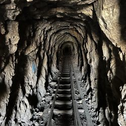
Mueller Tunnel
3 reviews
Ice House Canyon Trail
129 reviews
West Trail and Turner Trail To Captains Roost
2 reviews
Griffith Park