Big Horn Mine Photos


You might also consider
More like Big Horn Mine
Recommended Reviews - Big Horn Mine
Start your review...

Reviews With Photos

In the 1800's, Big Horn Mine obtained its name from Civil War veteran, Charles Tom Vincent. Supposed fugitive, admitting to killing 3 men who robbed him, he fled out to live in the San Gabriel Mountains. Here is where he discovered gold, while hunting Big Horn Sheep. If you're reading this, there is NO MORAL of this story, lol. Due to the heavy snowstorm the night before, I started hiking from Grassy Hallow Visitor Center. Ended up hiking 11.7 miles out and back. The highest point 6,890 ft with 1,873 ft total elevation gain. During winter months, snowshoes definitely needed, microspikes, hiking poles and the remainder of your "10 essentials" (REI has a good list online, if you don't know what I'm referring to). Look out for the posted signs for directions or use AllTrails to help you navigate to the mines. I parked along the main road (lot was full when I arrived around 8AM), and used an Adventure Parking Pass/Permit in case. Due to Snow Summit Ski area nearby, traffic during winter season is horrendous. So plan your trip here, accordingly. Happy adventuring to you and yours. Lastly, stay safe and healthy (mind, body and soul) Yelping out there :)

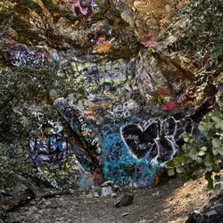
This place was somewhat interesting to see even with all that unnecessary graffiti at the mine. There's a parking lot right at the trail and most likely packed over the weekends. The trail itself was ~3.9 miles total and took about 1.5 hours to complete. It was mostly a dirt road with rocks all over. Highly recommend wearing two socks plus hiking shoes for some cushioning. It kind of feels easy to roll your ankle too. There were a few areas where the path was narrow and you really want to pay attention and take it really slow. Not too many shades so hiking during the summer could be brutal. Once you reach the building, the mine is located at the top. Watch your steps and bring a flashlight if you're into that. I did not go into the mine so not sure what's in there.

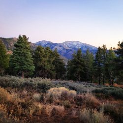
One of the better hikes I've been on this summer (2020). It's about a 4 mile hike (total), mostly uphill over a gravely rocky road. Lots of great views of the Angeles Forest. Lots of graffiti too. TIP, there are two trailheads from the parking lot. You must take the trail behind the white gate.. If you take the other path (very busy with hikers) you'll end up at the top of Mount Baden-Powell. When you arrive the at mine building you have to walk up behind the building to find the mine entrance. Yes, you can walk into the mine because people have cut the steel bars off. Bring a flashlight or just use your cell phone light.. Beware, the mine has bats and is full of mosquitoes... Bring plenty if deet repellent. Note, the parking lot will be full by 8AM on weekends. There is limited street parking in this area so get here early, or after the morning rush 2pm... An adventure Pass is required to park in the lot.. The pass can be purchased in town for $5.. There are conflicting reports if the sheriffs are actually enforcing the Adventure Pass or not, but I recommend to play it safe. - Not good for dogs, too many sharp rocks on the trail.


Hiked this over Memorial Day weekend to get away from the house during covid quarantine. Be warned that there are road closures on the 2 freeway currently, so make sure to check here before going: https://roads.dot.ca.gov/ When I went, the 2 was closed between Islip Saddle and Grassy Hallows. If you're trying to get to this hike, come around the 15 and 138 to drive through Wrightwood/Big Pines. Then take the 2 as about as close as you can get to Vincent Gulch Divide, which means parking on the side of the road at Grassy Hallows since the 2 was closed for further car entry for us at that point. You can then start walking - there's the option to take the Pacific Crest Trail, although we ended up walking directly on the 2 since the road was closed at this section and we didn't have to worry about cars. Don't underestimate this hike if you're new to hiking. Normally this hike is more on the easier end, but the road closures add an extra 3-4 miles one way, making this hike closer to 9-10 miles round-trip. Also I'm not sure if this trail was in a better / easier shape in past years, but there were about 3 trickier washed out spots when we went, and required making sure you had a good footing / balance before proceeding. There was quite a bit of loose rock and narrow spots where the trail was washed out, so I personally wouldn't recommend younger kids on here since you might slip off the side if you're not paying attention.

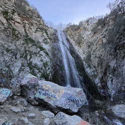
Very cool spot to hike go early before the heat and sun are on the whole trail. Par at the Vincent Gulch Divide/Vincent Gap. You need an Adventure Pass to park here. Trail for Big Horn Mine started behind the white gate. At the fork in the road stay to the right. It is a gradual incline with some rocky and narrow spots on the trail. Lovely views and baby waterfall when you reach the end at the mines. Bring really good flashlights if you plan on going into the mine it's pitch black and cold in there. The mine has several bifurcations and a green string to follow to lead you out to the opening. Small stream of water and lots of rocks in the Min also so low points be careful not to hit your head. Definitely will be back.

You would never know this hike existed if you drove by, but let me tell you it is definitely a hidden treasure. Like all treasure you're going to have to work for it, just a bit. The hike is about 1.5 to 2 miles one-way. It took us two hours round trip, but that included stopping and admiring the views on the way. On the way there, it's pretty much uphill, nothing steep but it can be a little much if you have any type of lung or heart condition, and I personally wouldn't bring kids. (But there were kids on the trail) About halfway in the trail turns into walking on the side of a mountain so make sure you wear appropriate hiking shoes to avoid any accidents. The trail also can get pretty hot with the sun beaming. Apparently you can climb into the mines when you get there, but we didn't go that far. We just went to enjoy the views with good company and some snacks. I personally wouldn't bring my dog because some parts of the trail are pretty sketch but some people brought their dogs.


We arrive there around 8:30 ish, it gave us enough time to hike and have plenty of stops on the way. The hike it self was pretty easy, just be careful and beware of your surrounding . There is a mini waterfall along the way also If you want to hike the mine be prepare to have a good flashlight, it gets pitch black. Overall a fun hike, to take your dog or just for a mini getaway. Tip: Bring a flashlight if you are going to hike the mine. Water resistance jacket because there water dripping in there. Make sure to buy a parking pass $35 for 2 passes, basically $15 each for the whole year. Snacks for the hike is good and for energy.

Had such an amazing time yesterday! 420Hikers had an event, hikers and cannabis. We had a big group come down, some camp in for the weekend and others did a one day hike. We just had a good time. Explored and enjoyed some cannabis and edibles. This hike to Big Horn was short hike but once there you can enter the cave and explore what is left of this old mine.

I'm a hiker, it's in my soul and this hike was one for the books. Don't miss out on it. When me and my family did this hike it was in January and still pretty cold out, Ice was stuck to the ground throughout the trail so I recommend sturdy, appropriate foot wear. We however didn't have any and went to a local store and bought yaktraks.. I believe that's how to spell it. They're this little wire contraption that you attach around your shoe and it hugs it providing support and grip against snow and ice. Id give this hike 100 stars if I could because the views speak for themselves, it's moderate in difficulty. Some portions of the hike are a little scary but so worth it. Just stay smart and safe. And bring water and snacks, the view at the top is breathtaking and a picnic is perfect! The entrance to the mine is technically blocked off but you can still get inside and it was a very cool creepy experience. If you love creepy like myself it's worth a peak!

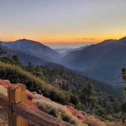
It is so hard to differentiate between a 4 and 5 star hike for me sometimes...this is a solid 4, wait 5, no 4...you get the picture. We hiked it for the 1st time yesterday and really enjoyed it. We plan on returning to do the Baden-Powell summit since the trailhead for that hike is in the same parking lot. Location- knew it was going to be a pretty long drive coming from the SE part of LA and a car accident on the 15 to and also on our return made it even longer. You have to drive on the winding 2 for a while before you reach the Vincent Gulch parking lot (Paolo and Laramae's reviews were helpful). Parking lot was pretty big and not very many people drive this far to hike so not very many cars at all. Adventure Parking Pass is needed. Trail- right beyond the white closed road gate. You start off downhill and there were quite a few flying bugs in this part until you reach a wooden sign indicating 2 miles to Big Horn Mine and the trail is a steady up hill from there on. It is not difficult but you may have a bit of difficulty acclimating to the higher altitude. Parts of the trail have shade but for the most part it is exposed to the sun. There are some great views. We didn't come across anyone on our ascent and maybe 10-15 on our way back. Mine- outside part of the mine has spectacular views and photo ops. We entered the mine...a bit difficult for my larger body but doable. Make sure to bring flashlights...we went in about 100-150 ft.

Big Horn Mine is a nice escape from the city, without having to travel too far. All trails will have you thinking it's a difficult hike, when the main thing to keep in mind is that you need to dress appropriately. Wear hiking boots/shoes and this will be a breeze. The recent fires still show some burn scars and lack of shade, so ideally get in/out before early afternoon. Other than that it's lovely. read more


7 months ago

1 year ago
This is definitely a must-see, just like any historical site. The hike itself isn't too bad--if you're in shape, it's a breeze, but it can be a bit challenging if you're not. My son, who weighs around 400 lbs and has gained weight due to a brain tumor, completed the hike. He struggled a bit during the last quarter but made it through. It took us a little over an hour with about three short stops. He didn't climb up to the mine ruins because he was tired, but overall, it was a great experience. I ventured about 400-500 feet into the cave, past the branched area where no natural light reaches. I brought a flashlight, which was essential. The views from the top are incredible, though it's disappointing to see tagging from immature individuals who likely don't understand why defacing such places is disrespectful. read more

In the 1800's, Big Horn Mine obtained its name from Civil War veteran, Charles Tom Vincent. Supposed fugitive, admitting to killing 3 men who robbed him, he fled out to live in the San Gabriel Mountains. Here is where he discovered gold, while hunting Big Horn Sheep. If you're reading this, there is NO MORAL of this story, lol. Due to the heavy snowstorm the night before, I started hiking from Grassy Hallow Visitor Center. Ended up hiking 11.7 miles out and back. The highest point 6,890 ft with 1,873 ft total elevation gain. During winter months, snowshoes definitely needed, microspikes, hiking poles and the remainder of your "10 essentials" (REI has a good list online, if you don't know what I'm referring to). Look out for the posted signs for directions or use AllTrails to help you navigate to the mines. I parked along the main road (lot was full when I arrived around 8AM), and used an Adventure Parking Pass/Permit in case. Due to Snow Summit Ski area nearby, traffic during winter season is horrendous. So plan your trip here, accordingly. Happy adventuring to you and yours. Lastly, stay safe and healthy (mind, body and soul) Yelping out there :) read more


This place was somewhat interesting to see even with all that unnecessary graffiti at the mine. There's a parking lot right at the trail and most likely packed over the weekends. The trail itself was ~3.9 miles total and took about 1.5 hours to complete. It was mostly a dirt road with rocks all over. Highly recommend wearing two socks plus hiking shoes for some cushioning. It kind of feels easy to roll your ankle too. There were a few areas where the path was narrow and you really want to pay attention and take it really slow. Not too many shades so hiking during the summer could be brutal. Once you reach the building, the mine is located at the top. Watch your steps and bring a flashlight if you're into that. I did not go into the mine so not sure what's in there. read more


One of the better hikes I've been on this summer (2020). It's about a 4 mile hike (total), mostly uphill over a gravely rocky road. Lots of great views of the Angeles Forest. Lots of graffiti too. TIP, there are two trailheads from the parking lot. You must take the trail behind the white gate.. If you take the other path (very busy with hikers) you'll end up at the top of Mount Baden-Powell. When you arrive the at mine building you have to walk up behind the building to find the mine entrance. Yes, you can walk into the mine because people have cut the steel bars off. Bring a flashlight or just use your cell phone light.. Beware, the mine has bats and is full of mosquitoes... Bring plenty if deet repellent. Note, the parking lot will be full by 8AM on weekends. There is limited street parking in this area so get here early, or after the morning rush 2pm... An adventure Pass is required to park in the lot.. The pass can be purchased in town for $5.. There are conflicting reports if the sheriffs are actually enforcing the Adventure Pass or not, but I recommend to play it safe. - Not good for dogs, too many sharp rocks on the trail. read more


Very unique, one of a kind hike. Most hikes you get nice views and nature. This one you get a mine and old structure you can take photos and chill. Inside the mine is pitch dark so make sure you bring a flashlight. Very fun to explore but be safe. read more


2 years ago
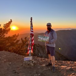
Love this place! Worth the hike! Definitely bring plenty of water, take breaks to enjoy the views and surroundings. I did it early in the morning and watched the sun rise. read more


2 years ago
Hiked this over Memorial Day weekend to get away from the house during covid quarantine. Be warned that there are road closures on the 2 freeway currently, so make sure to check here before going: https://roads.dot.ca.gov/ When I went, the 2 was closed between Islip Saddle and Grassy Hallows. If you're trying to get to this hike, come around the 15 and 138 to drive through Wrightwood/Big Pines. Then take the 2 as about as close as you can get to Vincent Gulch Divide, which means parking on the side of the road at Grassy Hallows since the 2 was closed for further car entry for us at that point. You can then start walking - there's the option to take the Pacific Crest Trail, although we ended up walking directly on the 2 since the road was closed at this section and we didn't have to worry about cars. Don't underestimate this hike if you're new to hiking. Normally this hike is more on the easier end, but the road closures add an extra 3-4 miles one way, making this hike closer to 9-10 miles round-trip. Also I'm not sure if this trail was in a better / easier shape in past years, but there were about 3 trickier washed out spots when we went, and required making sure you had a good footing / balance before proceeding. There was quite a bit of loose rock and narrow spots where the trail was washed out, so I personally wouldn't recommend younger kids on here since you might slip off the side if you're not paying attention. read more


6 years ago
Very cool spot to hike go early before the heat and sun are on the whole trail. Par at the Vincent Gulch Divide/Vincent Gap. You need an Adventure Pass to park here. Trail for Big Horn Mine started behind the white gate. At the fork in the road stay to the right. It is a gradual incline with some rocky and narrow spots on the trail. Lovely views and baby waterfall when you reach the end at the mines. Bring really good flashlights if you plan on going into the mine it's pitch black and cold in there. The mine has several bifurcations and a green string to follow to lead you out to the opening. Small stream of water and lots of rocks in the Min also so low points be careful not to hit your head. Definitely will be back. read more


6 years ago
You would never know this hike existed if you drove by, but let me tell you it is definitely a hidden treasure. Like all treasure you're going to have to work for it, just a bit. The hike is about 1.5 to 2 miles one-way. It took us two hours round trip, but that included stopping and admiring the views on the way. On the way there, it's pretty much uphill, nothing steep but it can be a little much if you have any type of lung or heart condition, and I personally wouldn't bring kids. (But there were kids on the trail) About halfway in the trail turns into walking on the side of a mountain so make sure you wear appropriate hiking shoes to avoid any accidents. The trail also can get pretty hot with the sun beaming. Apparently you can climb into the mines when you get there, but we didn't go that far. We just went to enjoy the views with good company and some snacks. I personally wouldn't bring my dog because some parts of the trail are pretty sketch but some people brought their dogs. read more


6 years ago
Such an awesome hike! Definitely a little rocky! But the end view, beautiful! You can actually go inside the mine too, but definitely need a flashlight. You can't go too far in either, too much water. Little gas station inside the small town is where you can get the parking pass $5. read more


7 years ago
We arrive there around 8:30 ish, it gave us enough time to hike and have plenty of stops on the way. The hike it self was pretty easy, just be careful and beware of your surrounding . There is a mini waterfall along the way also If you want to hike the mine be prepare to have a good flashlight, it gets pitch black. Overall a fun hike, to take your dog or just for a mini getaway. Tip: Bring a flashlight if you are going to hike the mine. Water resistance jacket because there water dripping in there. Make sure to buy a parking pass $35 for 2 passes, basically $15 each for the whole year. Snacks for the hike is good and for energy. read more


8 years ago
Had such an amazing time yesterday! 420Hikers had an event, hikers and cannabis. We had a big group come down, some camp in for the weekend and others did a one day hike. We just had a good time. Explored and enjoyed some cannabis and edibles. This hike to Big Horn was short hike but once there you can enter the cave and explore what is left of this old mine. read more


I'm a hiker, it's in my soul and this hike was one for the books. Don't miss out on it. When me and my family did this hike it was in January and still pretty cold out, Ice was stuck to the ground throughout the trail so I recommend sturdy, appropriate foot wear. We however didn't have any and went to a local store and bought yaktraks.. I believe that's how to spell it. They're this little wire contraption that you attach around your shoe and it hugs it providing support and grip against snow and ice. Id give this hike 100 stars if I could because the views speak for themselves, it's moderate in difficulty. Some portions of the hike are a little scary but so worth it. Just stay smart and safe. And bring water and snacks, the view at the top is breathtaking and a picnic is perfect! The entrance to the mine is technically blocked off but you can still get inside and it was a very cool creepy experience. If you love creepy like myself it's worth a peak! read more


It is so hard to differentiate between a 4 and 5 star hike for me sometimes...this is a solid 4, wait 5, no 4...you get the picture. We hiked it for the 1st time yesterday and really enjoyed it. We plan on returning to do the Baden-Powell summit since the trailhead for that hike is in the same parking lot. Location- knew it was going to be a pretty long drive coming from the SE part of LA and a car accident on the 15 to and also on our return made it even longer. You have to drive on the winding 2 for a while before you reach the Vincent Gulch parking lot (Paolo and Laramae's reviews were helpful). Parking lot was pretty big and not very many people drive this far to hike so not very many cars at all. Adventure Parking Pass is needed. Trail- right beyond the white closed road gate. You start off downhill and there were quite a few flying bugs in this part until you reach a wooden sign indicating 2 miles to Big Horn Mine and the trail is a steady up hill from there on. It is not difficult but you may have a bit of difficulty acclimating to the higher altitude. Parts of the trail have shade but for the most part it is exposed to the sun. There are some great views. We didn't come across anyone on our ascent and maybe 10-15 on our way back. Mine- outside part of the mine has spectacular views and photo ops. We entered the mine...a bit difficult for my larger body but doable. Make sure to bring flashlights...we went in about 100-150 ft. read more


5 years ago
Great hike if you are in the Wrightwood area. It took us a little over an hour to get to the mine. I wouldn't call the hike easy as I always take in to consideration kids and older folk. I would label the route a moderate hike but simple enough to do for most as the trail is moderately maintained. The view from inside the mine is a real treat, with plenty of picture opportunities. The actual structure takes you back into time as you imagine the life of a miner. We appreciated the cool graffiti, which adds another layer of character. We recommend this hike all the time, one of many hikes in the Wrightwood, Angeles Forest area. read more


 to the mine - Hiking Near Me")

11 years ago
LOVED the hike to Big Horn Mine. The hike itself was moderate with a few sections of intense incline and a couple of tricky down hill navigation but overall very doable for beginner hikers and enjoyable for intermediate hikers. Tips for a successful/enjoyable hike: - Buy an adventure pass ($5) at the Grassy Hallow Visitor Center to avoid the $100+ fine - it is on the way to the parking lot of the Big Horn Mine trail and the center is usually open until 4pm - Look up the weather and dress accordingly!! In the summer it can get pretty hot and during the fall/winter it can get pretty cold - I came here on 11/29/15 and there was snow starting to appear on the trail and it was a crisp 32 degrees - Wear sturdy shoes with good support - even though most of the trail is pretty easy and walkable, there are a couple of spots where having a good pair of shoes on will help you navigate the terrain with more certainty - Bring water - Save the map and special instructions on your phone the night before you go on the hike! There is no service ANYWHERE near the trail or on it Enjoy! read more


8 years ago
I absolutely loved this hike! I would consider this hike intermediate level. My hike duration was from 8am-1:00pm. Temperature was perfect mid 80s. Once I arrived to the abandoned building we took pictures and ate our snacks. I didn't pay for a permit and luckily didn't end up with a ticket. A lot of cars didn't have the pass so I figured we'd be ok. The hike at times tends to feel like you're heading in the wrong direction due to the lack of signs. Just ensure you take the trail named big horn mine. Location Type in Vincent Gap parking on your maps The parking lot is on your left Hike is also on your left read more


Big Horn Mine... was confused on how to find the trailhead initially, but fortunately got reception and read a few reviews on here that directed me to the white gate. Directions/parking: Use Vincent Gap Parking as your destination and you will be led right to it! An Adventure Pass is required for parking, but I winged it and managed to get dirt parking so I was okay. There is a limited amount of parking here, so if you go during peak hours, you'd have to get lucky. This seems to be a popular spot for hikers and there are multiple trails that use this lot. To get to Big Horn, follow the signs for 'Mine Gulch,' where you'd begin your hike at the white gate labeled 'Road Closed - Do Not Block Gate.' From here, you'd cruise roughly 2 miles to get to the mine. There are parts of the trail that can get narrow, and there is some incline, but overall it is an easy and doable hike. I loved that since we are so high in elevation, the air is sooo cool and you are basically hiking amongst the clouds. At first, I was pretty cold, but later on as the sun started coming out, the hike was just perfect. There is an ample amount of shade throughout the trail with many pretty flowers along the way. I saw plenty of wildlife.. squirrels, various colorful birds, rattlesnakes... it was the perfect amount of zen I needed to get away from the world's chaos. When you finally reach the top, the mine is accessible for you to freely go in. Definitely bring a flashlight if you decide to wonder around those tunnels! It was pretty neat to go through it. There are plenty of photo opportunities throughout this entire hike, would highly recommend! read more


8 years ago
This was our first trail- it was lovely-we thought it would be too hot but the weather is cooler as you go up the mountain. There were two spots we got to where I was a little nervous going but you just need to be careful (narrow trail). Coming back is easier because you know where your going. We were having a problem looking for the exact address for the location so we used: Angeles National Forest Big Rock Creek Rd Valyermo, CA 93563 United States This gets you to the location. We parked across the road from the Vincent gap parking lot so we don't have to purchase a parking permit. There's no network up the mountains. read more


10 years ago
What an awesome hike! I live in LA so it took about 1.5 hours to get to this hiking trial, but it was definitely worth it! The drive from Glendale up the mountains was a lot of fun for me - but I wouldn't recommend it to people who are afraid of driving curvy mountain roads. Once you get to the parking lot, don't forget to put up your Adventure Pass. If you don't have one, you can get it from the visitor's center or Big 5 beforehand. You'll probably want to use the restroom before starting the hike because that's the only one available in the area. At the beginning of the trail, pick the "Mine Gulch" trail (the left one). It's a short hike - 4.5 miles. It is relatively easy but there's a lot of annoying rocks on the ground, which can make it painful to walk. Just keep to the right side of the hike. Once you see the abandoned mine/cabin, you should hike down to where the small waterfall is and climb up to the cabin. The view from there is amazing! It's definitely instagram worthy. To find the tunnel system, you have to do some more climbing to the top (keep left of the cabin). After you have to climb into the tiny steel beams - BE CAREFUL! It's old and I heard that you can get a ticket for going inside. Don't forget to bring FLASHLIGHTS. I had my iPhone flashlight, which wasn't very useful if I were to enter deeper into the hole. It was too creepy for my taste so my friends and I left after a few minutes. read more


4 years ago
5 years ago
Good hike with amazing views. Would not recommend this trail for dogs. Disappointed to see all the vandalism along the way to the mine and more so, the trash left behind by careless visitors. read more


Hiked 7/25/2015 The trail is washed out! BUT... if you are adventurous and dare to cross loose rocks, it is still hikeable! Just be careful! The group of 4 of us managed to cross to washed out parts of the trail and we made it to the mines! Due to the heavy rain fall weekend prior, the trail has washed out in multiple places. Directions: type into google maps Vincent Gap. Which you take the 2 past Mountain High, and driving a little further you will see the parking lot. You need an Adventure Pass. Trail: We counted roughly 10 wash outs on the trail, 3 major ones. The first washout is the hardest to cross, but once you conquered that one, all the other washes are a walk in the park. Starting the trail, you go past the gate on the left. On the right is the trail to top of Baden Powell.The trail starts going down hill a little. The first part of the trail is easy, then you turn the corner and you see the wash out. WASH OUT #1: It's a 40 foot gap pretty much. We went down the loose rocks, crossed below, then climbed up to the other side of the trail. We saw others just go straight across, but that climb was a little steeper but doable. We saw a couple who looked like the were in their 40's cross, we also saw a dad with 4 boys age range 12-15 yrs old cross. We did see a lot of people turn away too. So do at your own risk. The other 2 big washouts were not as intense, just have a mindset of a Billie goat and you're good to go! You pass a first tunnel that looks like it's part of the mine, you keep going though then you will see the big mine structure. Once at the mine structure, you can wander up and into the mine tunnels. We wandered pretty far in. It's pretty awesome. We had a headlamp, and LED flashlight. Because of the rain, there was water inside. Roughly 4 miles round trip, took us 2-3 hours Good luck! read more


5 years ago
The best trail I've been to so far! Hike was a cool experience, nice views while you hike your way up, went all the way into the mine. The further you go in,the less oxygen you get , gets colder and harder to breathe. But it was definitely worth it ! I will be going back real soon ! read more


This is an easy hike with some pretty terrain. There are a couple of areas where the trail has eroded. These are not difficult to get around if you use care and follow the tracks others have made and watch your balance. Forest Service personnel and volunteers have rebuilt Vincent's Cabin although it's not viewable from the trail. I'm really glad I hiked this trail! read more

5 years ago
Great hike! Easy enough for kids, with a fantastic mine adventure at the end! Two miles one way plus any adventuring inside the mine. This is one of the few California hasn't caved in or fully barricaded. read more

8 years ago
This was an easy fun hike I took 2 "cool" teenagers (niece and nephew) and I found them smiling and laughing the whole time. We hiked all the way to the mine and went inside. The deeper you go in the colder it gets. It was creepy, the cool kids wanted to go further inside but I was like hell nah, I'm scared lol. I went on a Saturday in July it was hot Things you might want to take: Thermoflask filled with ice Extra water Good flashlight I suggest everyone who goes inside the mine has there own flashlight. Dont forget your Daily adventure parking pass, I bought one before heading up, just google where you can purchase one. I got my pass at a 7-11 in azusa read more


8 years ago
One of my favorite hikes in the Los Angeles area. This is a pretty simple in and back out hike, which usually takes about 2 hours with breaks. I have come here twice with my boyfriend and my dog. I love that it tires my dog out physically and mentally. The trail is relatively flat but the elevation of the mountain with lower oxygen can make it more difficult for some. We usually make a day trip of the hike by packing sandwiches for lunch and take a pit stop in the middle of our hike to enjoy the beautiful view. Due to the higher altitude, the temperature around the trail is always about 10-15 degrees cooler, so I recommend bringing a light jacket and wearing leggings. If you start your hike after 5/6 pm, you may also need head lamps as it gets quite dark. You will need an adventure pass to park in the parking lot, but you can buy one at the visitor center a few miles down the road or in advance at an REI. read more


8 years ago
This hiking trail had been on my list for a minute, so today, I can officially strike it off. The hike is moderate, but I highly recommend hiking shoes. Also, bring water and snacks, you will definitely want to relax and enjoy the view.. It's a safe trail, but does have narrow spots, so take your time and always be careful in the wilderness. This is a popular spot for photo opportunities, so try to hike early and beat the crowd. Thanks! read more


9 years ago
Highway has been closed for a few days now and as of 6/12 the road is still shut down. Trail is open though and you can park at the Grassy Hollow picnic area to hike 2 miles down to the trailhead. If open, parking lot seems to accommodate about 30 cars. There's a notification board and a (gross) restroom. Hike to Big Horn mine is about 2 miles out, at about half a mile there's a fork. The left (mine gulch) goes to Vincent's cabin and the right goes to the mines. Trail is on very easy terrain with only a 750ft elevation gain. First point of interest you'll hit is the free candy (dick) mine. You can slip through the slit and trespass to explore all 400ft of it in its waterlogged glory. Skip this part if you are terrified of getting your feet wet, the water will go up to your knees and it's freezing cold. The mining building is about half a mile from the first mine. Get those Instagram shots in here. I feel early morning gives you the best scene as the mountains are all blue and the haze of pollution isn't as apparent. The big mine is located above some rotting scaffolding on the left side of the building. You will have to shimmy through this one too. Try to bring a flashlight that has at least 300 lumens. Arrows guiding the way back outnumber the amount of tunnels in the mine. Hard to get lost! Avoid touching the moist wood, it's sticky and probably unsafe for consumption. I spent 30 minutes in here but I skipped a few tunnels. There's lots of graffiti scattered about; some of them dictate dead ends and those are all accurate. Try not to leave trash behind because hundreds of people before you have. Tip: Do the big mine before the water mine for a better time if you want to check out both. read more


9 years ago
I got here last Friday with my co-workers. It was really fun place to do hiking!! At the first time, we took a different course from the one we planned. And we changed the course quickly because we felt like it was not easy course we saw on the website. Finally, we got the course we wanted to take and finished 3 hours hiking well. It was very fun and I would like to recommend this course~ read more


9 years ago
Great hike for all ages, from beginner to advanced. On a Sunday morning (approx. 7 AM), the parking lot was still relatively empty. There was a couple of benches around (could be great for a morning picnic) and there was compost toilets to handle your business. Make sure you buy your $5 park pass at the bottom of the hill before you head up, since there is no way of purchasing passes in the parking lot. The hike was relatively easy, some inclines on the way to the mine, however, the toughest part was all the granite rocks on the trail. Make sure to wear good padded shoes, I would highly recommend to wear your hiking boots on this trail since it gives lots of support and you won't feel rocks at the bottom of your foot. The entire hike had great views all around. There was even a little abandoned mine tunnel that had a steady stream throughout (it's the one that says free candy). Obviously the major attraction is Big Horn Mine where you see an amazing view of the hills and mountains (perfect for that Instagram photo!). Friends of mine up to the abandoned mines and said it was very fun exploring and seemingly the mines went on forever. Overall, the hike was a total of 5 miles of hiking. I've seen plenty of dogs on the trail and even little kids hiking, perfect for everyone! My only deduction was the rocks on the trails because it made the hike a little more difficult if it was just pure dirt trails. Also when we arrived back to the parking lot, the whole lot was completely filled suggesting that this hike is becoming increasingly popular! read more

9 years ago
Nice place for a familky hike. This is a beginners hike depending on your physical fitness it might go to moderate but not hard at all. Go in early though because this place seems to attract a lot people and this hike being as easy and short as it is you might not get the best experience with all the people going in. read more


9 years ago
I loved this hike. It is a very popular one so I think it's interesting that they have not done any maintenance to the trail on areas where there has been landslides. Met some wonderful people along the way, including some older gentlemen that hike the area quite often and spoke of the deterioration of the mine itself the last couple of years. Bring strong flashlights and if you plan on going in to the mine deep, a way to mark your path that can be removed on your exit! (Leave no trace!) There are 20 miles underground . It's neat to know this was built in the 1800's... so there HAS to be ghosts! I was a little nervous thinking I would not make it in the entrance (being a fluffy unlikely hiker!) but read another hiker's review who was over 6ft, 200 lbs. and he made it so... BOOM!! Have fun. Take your time. Bring water and snacks. Be careful! Oh!! And you need an Adventure Pass to park! read more


10 years ago
Big Horn Mine earned its name after Charles Tom Vincent discovered gold while hunting for Big Horn Sheep in the area. In 1870 he built a small rustic cabin by hand and lived off the land for the next 40 years. He was supposedly a fugitive and was hiding out after killing 3 men who robbed him while living in Arizona. The cabin still exists and it is located not far off the trail. The trail that leads to the mine follows a wagon road that was built around the north slope of Mount Balden-Powell. The mine has an old Stamp Mill attached to the side of the mountain. Buried ore deposits were brought to the surface and the steam-powered rock crushers within the mill would pound the rocks to extract the ores. I hiked the trail in December and it was the first time that I had ever hiked in the snow. Even though it was a fairly short 4 mile roundtrip hike, the snow and the altitude made it feel much further and made it more strenuous. If you are interested in visiting Vincent's Cabin the junction where you can veer off the trail is located near the large metal sign that lists some basic camping tips. The cabin is a little difficult to locate but there are a few videos online that provide good directions. Once you reach the Stamp Mill, on the other side of the structure, there is a wooden ladder that you can climb to reach the opening of the mine. To get to the trailhead head to the town of Wrightwood. Continue west along Hwy 2, past Big Pines towards Inspiration Point. Continue on Hwy 2 from Inspiration Point, past Grassy Hollow Visitor's Center, down to the Vincent Gap parking area. Park at the Vincent Gap Parking lot and follow the Mine Gulch Trail. The white gate marks the entrance to the trail. Don't forget to display a National Forest Adventure Pass in the windshield of your vehicle. read more


Page 1 of 4
More info about Big Horn Mine
Ask the Community - Big Horn Mine
How does one reserve a camping space in Wrightwood? Or is it first come first serve?
What's the exact address to here? We want to see the tunnel and the beautiful view!?
lol there is no address... its a hike that you have to trek in to. Its a large parking lot on hwy 2 and if you google the parking lot it does show up on google maps...
Review Highlights - Big Horn Mine
You might also consider


Why does Yelp recommend reviews?
Big Horn Mine - hiking - Updated June 2026
Best of Wrightwood
People found Big Horn Mine by searching for…
Things to Do in Wrightwood, California
Free Snow Play in Wrightwood, California
Abandoned Buildings in Wrightwood, California
Hiking Trails With Waterfalls in Wrightwood, California
Attractions in Wrightwood, California
Campgrounds in Wrightwood, California
Parks in Wrightwood, California
Dog Friendly Things to Do in Wrightwood, California
Places to Take Pictures in Wrightwood, California
Scenic Drive in Wrightwood, California
Abandoned in Wrightwood, California
Off Road Trails in Wrightwood, California
Scenic View in Wrightwood, California
Beautiful Views in Wrightwood, California
Walking Trails in Wrightwood, California
Dog Friendly in Wrightwood, California
Parks for Kids in Wrightwood, California
Waterfalls and Swimming Holes in Wrightwood, California
Night View in Wrightwood, California
Snow in Wrightwood, California
Skyline View in Wrightwood, California
Landmarks in Wrightwood, California
Trending Searches in Wrightwood, CA
Black Owned Nail Salons near Big Horn Mine
Boat Rental near Big Horn Mine
Cliff Jumping near Big Horn Mine
Fishing Spots near Big Horn Mine
Jet Ski Rental near Big Horn Mine
Kayak Rental near Big Horn Mine
Lakes & Ponds near Big Horn Mine
Off Road Trails near Big Horn Mine
Outdoor Activities near Big Horn Mine
Places To Walk Around near Big Horn Mine
Public Shower near Big Horn Mine
River Swimming near Big Horn Mine
Rock Quarry near Big Horn Mine
Running Trails near Big Horn Mine
Scenic Night View near Big Horn Mine
Scenic Overlook near Big Horn Mine
Secluded Spots near Big Horn Mine
Soccer Store near Big Horn Mine
Strawberry Picking near Big Horn Mine
Sunrise View near Big Horn Mine
Swimming Holes near Big Horn Mine
Swimming Lakes near Big Horn Mine
U Pick Farms near Big Horn Mine
Watch Sunset near Big Horn Mine
Browse Articles
Browse Nearby
BEST of Wrightwood, California Parks near Big Horn Mine
BEST of Wrightwood, California Things to Do near Big Horn Mine
BEST of Wrightwood, California Coffee near Big Horn Mine
BEST of Wrightwood, California Restaurants near Big Horn Mine
BEST of Wrightwood, California Hot Springs near Big Horn Mine
BEST of Wrightwood, California Walking Trails near Big Horn Mine
BEST of Wrightwood, California Breakfast near Big Horn Mine
BEST of Wrightwood, California Campgrounds near Big Horn Mine
BEST of Wrightwood, California Visitor Centers near Big Horn Mine
Browse Brands
Related Searches in Wrightwood, CA
Best Fishing Locations and Guides in Wrightwood, California
Best Nature Trails for Hiking in Wrightwood, California
Best Places for Horseback Riding in Wrightwood, California
Best Sledding Spots and Fun in Wrightwood, California
Check Out Off Road Trails in Wrightwood, California
Discover Dog Friendly Trails to Explore in Wrightwood, California
Discover Scenic Bike Paths in Wrightwood, California
Discover Scenic Mountain Bike Trails Near Wrightwood, California
Discover Top Nature Parks to Visit in Wrightwood, California
Discover a Hiking Trail in Wrightwood, California
Discover the Best Night Hike Trails in Wrightwood, California
Discover the Best Running Track in Wrightwood, California
Dog-Friendly Hikes With Dogs in Wrightwood, California
Effective Stairs Workout Spots in Wrightwood, California
Enjoy Camping Adventures Around Wrightwood, California
Enjoy Exciting Mountain Biking Adventures in Wrightwood, California
Enjoy Tent Camping Spots Around Wrightwood, California
Enjoy a Beautiful Waterfall Hike in Wrightwood, California
Enjoy the Best Tubing Experiences in Wrightwood, California
Enjoy the Best Walking Path in Wrightwood, California
Enjoy the Best Walking Trails in Wrightwood, California
Exciting Cliff Jumping Spots in Wrightwood, California
Explore Beautiful Parks and Green Spaces in Wrightwood, California
Explore Easy Hikes Perfect for All in Wrightwood, California
Explore Fun Activities to Do in Wrightwood, California
Explore Popular Campgrounds Near Wrightwood, California
Explore Scenic Lakes to Visit in Wrightwood, California
Explore Top Dog Parks in Wrightwood, California Near You
Explore the Best Swimming Holes Around Wrightwood, California
Explore the Best Trail Options in Wrightwood, California
Find Beautiful Views in Wrightwood, California
Find Cozy Camping Cabins in Wrightwood, California
Find Popular Ziplining Spots Around Wrightwood, California
Find the Best Parks for Picnics in Wrightwood, California
Find the Best Playgrounds to Visit in Wrightwood, California
Find the Best Scenic View Locations in Wrightwood, California
Hiking Trails With Waterfalls in Wrightwood, California
Off Leash Dog Hiking Trails in Wrightwood, California
Plan a Scenic Drive Route Near Wrightwood, California
Popular Fishing Spots to Explore in Wrightwood, California
Popular Picnic Spots to Visit in Wrightwood, California
Safe River Swimming Areas in Wrightwood, California
Safe and Fun Parks for Kids in Wrightwood, California
Top Climbing Spots and Gyms in Wrightwood, California
Top Paddleboarding Activities in Wrightwood, California
Top Running Trails to Explore in Wrightwood, California
Top Swimming Lakes to Enjoy in Wrightwood, California
Top Swimming Spots and Pools in Wrightwood, California
People who viewed Big Horn Mine also viewed
Mormon Rocks Interpretive Trail
8 reviews
Blue Ridge Trail
15 reviews
Third Stream Falls
13 reviews
Deep Creek Hot Springs Campground
266 reviews
Bonita Falls
164 reviews
Indian Rock Camp
4 reviews
Rainbow Bridge Via Pacific Crest Trail
4 reviews
Will Abell Memorial Trail at Arrowhead Ridge
17 reviews
Devil's Backbone
63 reviews
Cleghorn Ridge Trail
18 reviews