Mount Baden-Powell Trail Photos


You might also consider
More like Mount Baden-Powell Trail
Recommended Reviews - Mount Baden-Powell Trail
Start your review...

Reviews With Photos

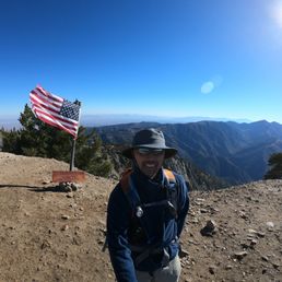
I love this trail...definitely one of my favorite local hikes. I love that you get the great views of being at over 9,300 ft without too long or overly arduous hike like some of the other local peaks. I highly recommend this hike for those who haven't done it and I look forward to coming back and enjoying this one many times and I have done it twice in less than 6 months. Parking- Vincent Gap parking lot off Hwy 2...we have gotten there early so it has never been an issue finding a spot and it is a rather large lot (you do need an Adventure Pass) Trail- it starts near the restroom...the trail to the left going down will take you to Big Horn Mine and the trail going up will take you steeply up to Baden-Powell and there will be many switchbacks and many great views as you make your way up; at about a mile there is a cool wooden bench to catch your breath or catch the great view; it is about 4 miles to the top and you will reach a 1,500 yr old tree less than a half a mile from the top called "Wally Waldron" at a flat kinda narrow portion that is a mini Devil's Backbone; you will then make one final ascent up to the peak where you will see a monument to the namesake who was a Boy Scouts leader and a pole with a writing station that contains some notebooks to log your thoughts, message, etc... and just beyond that you should find the wooden sign that you can hold with the elevation and a US flag Peak- there is a pretty large area at the top for you to find a spot for yourself/group to not bother others or be bothered by others and there are 360 degree beautiful views Distance- about 8 miles Elevation Gain- about 2,800 ft Peak- about 9,400 ft Duration- between 4 to 6 hrs depending of course on your speed, how many breaks, and how long you spend at the top Difficulty- Moderate to Hard (definitely easier than the other SoCal peaks like Mt Baldy or San Jacinto)

A newer trail that was added to the six pack of peaks as an alternate. Mount Baden-Powell trail also has connections to the Pacific Crest trail in the beautiful Angeles National Forest. It is an 8 mile hike. We have hiked more than on one occasion and it is one of my favorites and a great trail to train for bigger peaks. The 8 miler reaches the summit in quite a fashion. The famous trail ascends over 3,000 feet and the switchbacks are nestled in the shade of the tall forest trees. Once you are at the ridge you reach the Wally Waldorn tree, a must see. The summit is exposed but it does have some spots that are covered to rest up or simply enjoy your summit at the top. It is a strenuous hike but so worth it!

Hiked: Saturday June 6, 2015 Hours it took us: 6 hours Miles: 8 miles round trip Elevation gain: 2800 ft Elevation at the peak: 9,399 ft Drove out to Vincent Gap to climb Mt Baden-Powell on a Saturday, we hit the trail around 8:30 am. The parking lot was not full at all at that hour, we thought it would have been more crowded, especially since it was National Trails Day! It is a trek to get to though, we drove from Chino Hills and it took us almost an hour and a half to get to Vincent Gap. You past Mountain High Ski Lefts on the way out there. Definitely worth the drive though, such an amazing hike! Directions: I was able to type into Google maps Mt Baden Powell and it brought up the directions just fine, routed us there even with no service. It's off the 2 Highway Trail: it's really well marked. You gain elevation right away. There are a ton of switchbacks, from one site it said it has 30 switchbacks, but my trail book I have says 42, either way you lose count. My trekking poles definitely were helpful. The first notable thing you pass is a bench that over looks the road, then a few more switchbacks brings you to a sign pointing left towards some springs (I think that's the only water source along this trail). Once your higher on the trail, and you think your almost there, you're not. You got a lil ways still to go pass the Wally Waldron Tree, then you go on the trail part that's on the ridge of the mountain, THEN your practically there. So pretty at the top and throughout the hike! Tips from me: bring hiking poles, they're useful. Pack a lunch, maybe a windbreaker, and a lunch for the top!
It's about an hour and half drive from Los Angeles. But the hike is worth it, and you can knock out two trails in a day at the same parking lot. Vincent Gap is a little bit past mountain high ski resort. If you google map Vincent Gap, it will take you perfectly to the start of the trail head. Make sure to display your adventure pass. The hike is about 8 mile round trip. There are restrooms here, but it stinks, so bring some wipes and hand sanitizers. There are posted signs, but the start of the trail is the wooded fence going up the hill. Just continue up to about 40 plus switchbacks. You will see an Lamel Spring sign, just continue going up on the switchbacks. The views hiking up was okay. Once in a while you get a nice view. But going up on the switchbacks, there wasn't much great views till you get near the end where you see Wally Waldron tree. This is where the views are beautiful. From here to the summit, you probably will take lots of pictures. At summit, you will see I think a boy scouts monument, which was pretty cool, and an american flag. I really like this hike because the incline was gradual due to all the switchbacks, so it wasn't so difficult like some of the other trails in the Mount Baldy area. I would make it an all day event, when you come back down to the parking lot, go pass the white gate and do bighorn mine which is a 4 mile round trip and considered an easy hike. It's worth a look since you already drove a bit to get here, unless you live close by to this area. As always, pack accordingly to the weather and have fun. NOTE, winter time, there are possible risk when trails are snow covered, so be careful as there are drop offs.


The Mount Baden-Powell Trail shares the same parking lot as the Big Horn Mine Trail!! Buy an adventure pass at the visitor's center to avoid any tickets. My family and I came out here after Thanksgiving to hike but were stopped short due to the icy pathways. The trail is single file and uphill for the less than 2 miles we were on it so be careful when going in the winter!! We saw many geared up hikers coming down the mountain and telling us that they couldn't finish the hike and recommended that we (in our Nikes) be careful or just cut our losses. Even though we did not make it to the top, the scenery is beautiful and the air is extra fresh. We had a good time taking pictures and playing in the small amounts of snow. I will definitely be back in the spring or fall to finish this trail (due to the incline, I don't recommend this for the summer time unless you go extra early). Until next time...

Best hike of the season. It is really well maintained, shady for most of the trail and has a huge area at the summit. A relatively short hike that can challenge you but isn't too difficult with a payoff of magnificent views. Its also pretty shaded for much of the trail and we enjoyed a nice breeze along the way. Its a really peaceful trail and there's lots of cool trees along the way. I was disapointed there was no flag at the summit but there's a cool sign and also a journal where you can write something. We started at Vincent gap and the parking lot was pretty open at 6am on Sunday. Make sure to bring your adventure pass to park. There's a primitive bathroom there and some benches. I think we clocked in 8-9 miles. I was able to get reception on some of the hike which was cool because I was meeting up with people after the hike and we were taking a little longer than anticipated. I loved this hike and would definitely do again.

Liked the 16 mile round trip via Islip Saddle. North facing slope mostly, so cool in July with decent breeze when temps in Wrightwood were in 90s. Sorry to say made one wrong turn on descent from not stopping to study sign that was hard to read (turned toward Vincent Gap versus Islip Saddle). Thankfully only got 10 minutes down the wrong trail before a hiking buddy noticed error. She gets a gold star for noticing promptly. Like the sign on top of Mount BP, for photos, though it needs paint. Could use a similar sign on Mt Burnham, which was climbed enroute to Mount BP. Used GaiaGPS, for map, which was handy.

Really great hike, especially for the LA area! I did the hike on October 7 and the weather was perfect--nice crisp area, never got too hot. We drove up from LA and got to the trailhead around 9am. I was worried about finding parking since I usually like to start hikes earlier, but the parking lot was only about a quarter full when we got there. I was also worried about whether Highway 2 was going to be open since Google maps kept insisting that it was closed, but I actually Facebook messaged the Angeles Crest Highway account and they responded fairly quickly saying they were open, which was super helpful. There's a serviceable bathroom at the trailhead, and the trail itself is well-traveled and has signs pointing you in the right direction. We probably saw about 50 hikers over the course of the hike, but it was pretty spread out so it never got crowded at any point. The hike itself is beautiful and fairly shady until you get closer to the summit. The hike itself is a steady uphill climb, and I found myself struggling with the elevation starting around the halfway point. I'm a fairly experienced hiker, but anytime I hit around 9000 feet, my heartrate shoots up and I start breathing a lot more heavily than normal for the amount of exertion I'm putting in. A note of warning... I take my dogs hiking all the time, but this particular trail has a lot of loose little sharp rocks that was pretty rough on their paws. We had to slow down considerably on the way down because one of them unfortunately started limping and bleeding.

This hike was a toughie, but a goodie! Sitting here 3 days later, my legs are just easing up on soreness that I felt Monday and Tuesday. Came in from San Diego, the drive during COVID was easy peasy 2 hours and 10 minutes. Parked in the lot around 10am no problem, with our Adventure Pass. Headed up the mountain shortly after. There must be a lot of people that do a portion of the hike, because the first mile was pretty packed, but after that it really thinned out. The first mile is also super narrow, so when you're walking past people you're really squeezing past them. To my surprise and relief many other hikers had masks for passing. Overall this hike took us 5 hours 20 minutes, including a bunch of snack breaks along the way, and a longer stop at the top for pictures and lunch. First few miles were hot, we were in tanks. Then last mile or so got pretty windy, had our jackets on, and were holding on to our hats. At the top the wind came and went, but we found a spot semi protected by a tree to eat lunch at. Views from the top are STUNNING. Everything along the way is nice to look at, but I can't imagine doing a portion of the hike and not wanting to get to the top! Hike back down was easier, we finished up and headed into "town" for a beer before heading home.


This hike is about 8 miles roundtrip, out and back, with 2807' elevation gain/loss. The trail is single file with limited loose rocks under foot. It is a steady incline for most of the way with very limited steep ascensions. There are some shaded areas along the way. At the peak you are surrounded by a 360 degree view of the mountains.. You will see a monument dedicated to Mr Baden Powell, the founder of the Boy Scouts. There is a ledger that you can sign nearby as well. parking - small lot. Adventure pass required tip - if you want a more difficult hike, you can continue on to Ross Mountain for another 2.7 miles. Just be forewarned that the hike on the way back to Baden-Powell is fairly steep, as Ross Mountain is about 2000 feet lower.

For being a short hike to a mountain peak, this was still a little intense... with an awesome 360 degree panoramic view at the 9,399 foot peak! The round trip is only 8 miles, including a short side detour to a dry Lamel Springs, and up the well defined seemingly endless switchbacks. Mt Baden-Powell is the 4th highest peak in the San Gabriel Mountains. It was originally known as North Baldy until 1931 when it was renamed after Lord Baden-Powell, the founder of the Boy Scouts. I started my hike at the Vincent Gap trail head. From the 15 Freeway, take Highway 138 towards Palmdale. Then take Highway 2, the Angeles Crest Highway towards Wrightwood. After driving 14 miles on Hwy 2, you will see a 'Pacific Crest Trail parking' sign on the right at the Vincent Gap parking lot. http://www.yelp.com/user_local_photos?userid=RoGuDu1egfAvVgb4WmZwUw&select=oAAnaSQihK8P-qLYB3U9aA The Pacific Crest Trail that takes you up to Mt Baden-Powell starts just behind the bathroom on the left side of the road. The trail starts off steep right away. About a mile up there is a nice wooden bench where you can sit down and admire the trees and the tiny road below. But the best part of the trail for me was near 3.5 miles on the ridge crest as you head towards the ''Wally'' Waldron Tree, a 1,500 year old Limber Pine. All these old trees have their own characteristics. Think of all the hikers they must have seen pass by... Once on top, you see the Boy Scouts cement monument and the awesome views! Mt Baldy is South East, and if you look far off to the South West you will see the Mount Wilson antennas. Also on top you will see a pipe sticking out of the ground that was part of the original flagpole that was erected by the Boy Scouts in 1931. Yes... this was another great hike that I experienced with my pooch Sammy. Now we can't wait to hike this in the snow! http://www.yelp.com/biz_photos/mount-baden-powell-trail-wrightwood?select=6i521uODEMbsA87M_L_OYA&userid=RoGuDu1egfAvVgb4WmZwUw&utm_campaign=www_photo_share_popup&utm_medium=copy_link&utm_source=(direct)

1 year ago
They closed the road just past mountain high, which is 5 miles from the trailhead. You can park outside and the hike will add an extra 10 miles to the already challenging 9.5 mile hike up the mountain. There is an elevation gain of 4000ft. Views totally worth it! read more


Tremendous hike, Mt. Baden-Powell is a newer addition to the Six Pack Peak Challenge. Quick rundown, the hike is 8 miles total starting from Vincent Gap off of Hwy 2. Four miles up almost 3,000 feet elevation gain, & 4 miles back down. A lot of the trail is shaded by trees, once you've gone up around 1,000 feet up the mountain you'll start to get some good views of the antelope valley & the rest of that surrounding area. This hike is a bit challenging, but not as difficult as nearby Mt. Baldy, or Cucamonga. The multiple switchbacks makes the decent down easier to get through. There are a few other trails that lead to Baden-Powell like Dawson Saddle, but the most know is from Vincent Gap, you can look that name up by gps & get directions to the start of the trail. Like most of the big trails you'll need to have an adventure pass displayed for parking so you don't get a ticket. When you make it to the top you'll have some awesome views. There are a lot of nice picture here that people have posted at the top, but none of them do justice to what it's like to experience it in person. read more


3 years ago
Mochi - my faithful 9-yr old maltipoo who LOVES HIKING. Sun or snow he never fails to make it to the top - elevation 9,406' !! Been coming here for years and if you're lucky, on the way down, you can see Mochi belly slide on the dirt/sandy parts superman style. It's too cute & i think it's his short cut! One day I'll catch it on video... read more


I love this trail...definitely one of my favorite local hikes. I love that you get the great views of being at over 9,300 ft without too long or overly arduous hike like some of the other local peaks. I highly recommend this hike for those who haven't done it and I look forward to coming back and enjoying this one many times and I have done it twice in less than 6 months. Parking- Vincent Gap parking lot off Hwy 2...we have gotten there early so it has never been an issue finding a spot and it is a rather large lot (you do need an Adventure Pass) Trail- it starts near the restroom...the trail to the left going down will take you to Big Horn Mine and the trail going up will take you steeply up to Baden-Powell and there will be many switchbacks and many great views as you make your way up; at about a mile there is a cool wooden bench to catch your breath or catch the great view; it is about 4 miles to the top and you will reach a 1,500 yr old tree less than a half a mile from the top called "Wally Waldron" at a flat kinda narrow portion that is a mini Devil's Backbone; you will then make one final ascent up to the peak where you will see a monument to the namesake who was a Boy Scouts leader and a pole with a writing station that contains some notebooks to log your thoughts, message, etc... and just beyond that you should find the wooden sign that you can hold with the elevation and a US flag Peak- there is a pretty large area at the top for you to find a spot for yourself/group to not bother others or be bothered by others and there are 360 degree beautiful views Distance- about 8 miles Elevation Gain- about 2,800 ft Peak- about 9,400 ft Duration- between 4 to 6 hrs depending of course on your speed, how many breaks, and how long you spend at the top Difficulty- Moderate to Hard (definitely easier than the other SoCal peaks like Mt Baldy or San Jacinto) read more


A newer trail that was added to the six pack of peaks as an alternate. Mount Baden-Powell trail also has connections to the Pacific Crest trail in the beautiful Angeles National Forest. It is an 8 mile hike. We have hiked more than on one occasion and it is one of my favorites and a great trail to train for bigger peaks. The 8 miler reaches the summit in quite a fashion. The famous trail ascends over 3,000 feet and the switchbacks are nestled in the shade of the tall forest trees. Once you are at the ridge you reach the Wally Waldorn tree, a must see. The summit is exposed but it does have some spots that are covered to rest up or simply enjoy your summit at the top. It is a strenuous hike but so worth it! read more


Hiked: Saturday June 6, 2015 Hours it took us: 6 hours Miles: 8 miles round trip Elevation gain: 2800 ft Elevation at the peak: 9,399 ft Drove out to Vincent Gap to climb Mt Baden-Powell on a Saturday, we hit the trail around 8:30 am. The parking lot was not full at all at that hour, we thought it would have been more crowded, especially since it was National Trails Day! It is a trek to get to though, we drove from Chino Hills and it took us almost an hour and a half to get to Vincent Gap. You past Mountain High Ski Lefts on the way out there. Definitely worth the drive though, such an amazing hike! Directions: I was able to type into Google maps Mt Baden Powell and it brought up the directions just fine, routed us there even with no service. It's off the 2 Highway Trail: it's really well marked. You gain elevation right away. There are a ton of switchbacks, from one site it said it has 30 switchbacks, but my trail book I have says 42, either way you lose count. My trekking poles definitely were helpful. The first notable thing you pass is a bench that over looks the road, then a few more switchbacks brings you to a sign pointing left towards some springs (I think that's the only water source along this trail). Once your higher on the trail, and you think your almost there, you're not. You got a lil ways still to go pass the Wally Waldron Tree, then you go on the trail part that's on the ridge of the mountain, THEN your practically there. So pretty at the top and throughout the hike! Tips from me: bring hiking poles, they're useful. Pack a lunch, maybe a windbreaker, and a lunch for the top! read more


8 years ago
It's about an hour and half drive from Los Angeles. But the hike is worth it, and you can knock out two trails in a day at the same parking lot. Vincent Gap is a little bit past mountain high ski resort. If you google map Vincent Gap, it will take you perfectly to the start of the trail head. Make sure to display your adventure pass. The hike is about 8 mile round trip. There are restrooms here, but it stinks, so bring some wipes and hand sanitizers. There are posted signs, but the start of the trail is the wooded fence going up the hill. Just continue up to about 40 plus switchbacks. You will see an Lamel Spring sign, just continue going up on the switchbacks. The views hiking up was okay. Once in a while you get a nice view. But going up on the switchbacks, there wasn't much great views till you get near the end where you see Wally Waldron tree. This is where the views are beautiful. From here to the summit, you probably will take lots of pictures. At summit, you will see I think a boy scouts monument, which was pretty cool, and an american flag. I really like this hike because the incline was gradual due to all the switchbacks, so it wasn't so difficult like some of the other trails in the Mount Baldy area. I would make it an all day event, when you come back down to the parking lot, go pass the white gate and do bighorn mine which is a 4 mile round trip and considered an easy hike. It's worth a look since you already drove a bit to get here, unless you live close by to this area. As always, pack accordingly to the weather and have fun. NOTE, winter time, there are possible risk when trails are snow covered, so be careful as there are drop offs. read more


8 years ago
40 switchbacks...not bad at all! I suggest, go real early. It gets pretty crowded. The trail is clean and not as hard as I thought it will be. read more


10 years ago
The Mount Baden-Powell Trail shares the same parking lot as the Big Horn Mine Trail!! Buy an adventure pass at the visitor's center to avoid any tickets. My family and I came out here after Thanksgiving to hike but were stopped short due to the icy pathways. The trail is single file and uphill for the less than 2 miles we were on it so be careful when going in the winter!! We saw many geared up hikers coming down the mountain and telling us that they couldn't finish the hike and recommended that we (in our Nikes) be careful or just cut our losses. Even though we did not make it to the top, the scenery is beautiful and the air is extra fresh. We had a good time taking pictures and playing in the small amounts of snow. I will definitely be back in the spring or fall to finish this trail (due to the incline, I don't recommend this for the summer time unless you go extra early). Until next time... read more


Best hike of the season. It is really well maintained, shady for most of the trail and has a huge area at the summit. A relatively short hike that can challenge you but isn't too difficult with a payoff of magnificent views. Its also pretty shaded for much of the trail and we enjoyed a nice breeze along the way. Its a really peaceful trail and there's lots of cool trees along the way. I was disapointed there was no flag at the summit but there's a cool sign and also a journal where you can write something. We started at Vincent gap and the parking lot was pretty open at 6am on Sunday. Make sure to bring your adventure pass to park. There's a primitive bathroom there and some benches. I think we clocked in 8-9 miles. I was able to get reception on some of the hike which was cool because I was meeting up with people after the hike and we were taking a little longer than anticipated. I loved this hike and would definitely do again. read more


8 years ago
Liked the 16 mile round trip via Islip Saddle. North facing slope mostly, so cool in July with decent breeze when temps in Wrightwood were in 90s. Sorry to say made one wrong turn on descent from not stopping to study sign that was hard to read (turned toward Vincent Gap versus Islip Saddle). Thankfully only got 10 minutes down the wrong trail before a hiking buddy noticed error. She gets a gold star for noticing promptly. Like the sign on top of Mount BP, for photos, though it needs paint. Could use a similar sign on Mt Burnham, which was climbed enroute to Mount BP. Used GaiaGPS, for map, which was handy. read more


9 years ago
Really great hike, especially for the LA area! I did the hike on October 7 and the weather was perfect--nice crisp area, never got too hot. We drove up from LA and got to the trailhead around 9am. I was worried about finding parking since I usually like to start hikes earlier, but the parking lot was only about a quarter full when we got there. I was also worried about whether Highway 2 was going to be open since Google maps kept insisting that it was closed, but I actually Facebook messaged the Angeles Crest Highway account and they responded fairly quickly saying they were open, which was super helpful. There's a serviceable bathroom at the trailhead, and the trail itself is well-traveled and has signs pointing you in the right direction. We probably saw about 50 hikers over the course of the hike, but it was pretty spread out so it never got crowded at any point. The hike itself is beautiful and fairly shady until you get closer to the summit. The hike itself is a steady uphill climb, and I found myself struggling with the elevation starting around the halfway point. I'm a fairly experienced hiker, but anytime I hit around 9000 feet, my heartrate shoots up and I start breathing a lot more heavily than normal for the amount of exertion I'm putting in. A note of warning... I take my dogs hiking all the time, but this particular trail has a lot of loose little sharp rocks that was pretty rough on their paws. We had to slow down considerably on the way down because one of them unfortunately started limping and bleeding. read more


This hike was a toughie, but a goodie! Sitting here 3 days later, my legs are just easing up on soreness that I felt Monday and Tuesday. Came in from San Diego, the drive during COVID was easy peasy 2 hours and 10 minutes. Parked in the lot around 10am no problem, with our Adventure Pass. Headed up the mountain shortly after. There must be a lot of people that do a portion of the hike, because the first mile was pretty packed, but after that it really thinned out. The first mile is also super narrow, so when you're walking past people you're really squeezing past them. To my surprise and relief many other hikers had masks for passing. Overall this hike took us 5 hours 20 minutes, including a bunch of snack breaks along the way, and a longer stop at the top for pictures and lunch. First few miles were hot, we were in tanks. Then last mile or so got pretty windy, had our jackets on, and were holding on to our hats. At the top the wind came and went, but we found a spot semi protected by a tree to eat lunch at. Views from the top are STUNNING. Everything along the way is nice to look at, but I can't imagine doing a portion of the hike and not wanting to get to the top! Hike back down was easier, we finished up and headed into "town" for a beer before heading home. read more


6 years ago
6 years ago
One of my favorites and possibly the most gorgeous summit in the Ángeles National Forest. Great trail conditions .... I recommend it if you're looking for spectacular views. read more


10 years ago
This hike is about 8 miles roundtrip, out and back, with 2807' elevation gain/loss. The trail is single file with limited loose rocks under foot. It is a steady incline for most of the way with very limited steep ascensions. There are some shaded areas along the way. At the peak you are surrounded by a 360 degree view of the mountains.. You will see a monument dedicated to Mr Baden Powell, the founder of the Boy Scouts. There is a ledger that you can sign nearby as well. parking - small lot. Adventure pass required tip - if you want a more difficult hike, you can continue on to Ross Mountain for another 2.7 miles. Just be forewarned that the hike on the way back to Baden-Powell is fairly steep, as Ross Mountain is about 2000 feet lower. read more


7 years ago
For being a short hike to a mountain peak, this was still a little intense... with an awesome 360 degree panoramic view at the 9,399 foot peak! The round trip is only 8 miles, including a short side detour to a dry Lamel Springs, and up the well defined seemingly endless switchbacks. Mt Baden-Powell is the 4th highest peak in the San Gabriel Mountains. It was originally known as North Baldy until 1931 when it was renamed after Lord Baden-Powell, the founder of the Boy Scouts. I started my hike at the Vincent Gap trail head. From the 15 Freeway, take Highway 138 towards Palmdale. Then take Highway 2, the Angeles Crest Highway towards Wrightwood. After driving 14 miles on Hwy 2, you will see a 'Pacific Crest Trail parking' sign on the right at the Vincent Gap parking lot. http://www.yelp.com/user_local_photos?userid=RoGuDu1egfAvVgb4WmZwUw&select=oAAnaSQihK8P-qLYB3U9aA The Pacific Crest Trail that takes you up to Mt Baden-Powell starts just behind the bathroom on the left side of the road. The trail starts off steep right away. About a mile up there is a nice wooden bench where you can sit down and admire the trees and the tiny road below. But the best part of the trail for me was near 3.5 miles on the ridge crest as you head towards the ''Wally'' Waldron Tree, a 1,500 year old Limber Pine. All these old trees have their own characteristics. Think of all the hikers they must have seen pass by... Once on top, you see the Boy Scouts cement monument and the awesome views! Mt Baldy is South East, and if you look far off to the South West you will see the Mount Wilson antennas. Also on top you will see a pipe sticking out of the ground that was part of the original flagpole that was erected by the Boy Scouts in 1931. Yes... this was another great hike that I experienced with my pooch Sammy. Now we can't wait to hike this in the snow! http://www.yelp.com/biz_photos/mount-baden-powell-trail-wrightwood?select=6i521uODEMbsA87M_L_OYA&userid=RoGuDu1egfAvVgb4WmZwUw&utm_campaign=www_photo_share_popup&utm_medium=copy_link&utm_source=(direct) read more


12 years ago
Holy moly, this trail kicked my ass, big time. It was definitely an ass kicking worth taking though. We arrived at the trail just before 8am and there were only 3 other cars in the parking lot. There is a bathroom in the parking lot but it is very bare bones and more like a hole in the ground. I mean, you are in the middle of the mountains, so it's definitely better than nothing, but make sure to bring some baby wipes and Purell. I had read up on the trail for awhile and knew it was going to be difficult. I had even done some training hikes in anticipation of doing this hike. It was more difficult than I was probably really prepared for. Around the end of the first mile there is a bench with a lookout which was awesome. At the bench I met a fellow hiker who said he's done the trail a bunch of times and it always kicks his butt. So, I definitely knew what I was in for. It was at this point that I decided I was just going to take my time and hopefully eventually I would find myself at the peak. All of the other hikers I met, including a bunch of people doing the Pacific Coast Trail, were MEGA friendly. Everyone exchanged encouraging words and everyone seemed to agree that this is one steep trail. There were only a few patches of snow left on the trail when I did it. It does get more breezy the higher you go and it was definitely cold at the peak when I eventually made my way there. I would suggest packing layers of clothes, I was certainly grateful to have my REI hoodie to throw on while enjoying a snack at the peak. The way down does go a lot quicker than the way up. I highly recommend poles as I would have surely injured myself by tripping several times if I wouldn't have had mine. This was the first time I ever appreciated having poles on a hike, so that was a fun moment for me. The scenery here is just beyond anything I am able to describe with words. While I may never have the courage to do this hike again, I will always be grateful that I was able to haul my butt up this mountain to take it all in. Just totally gorgeous. It took us over 5 hours to get up and back down the mountain, but like I said, I took my time getting up to the top. You do need an adventure pass to park in this parking lot. I recommend bringing lots of water and a good camera to try and capture the beauty you'll experience. read more


Hiked this in the beginning of November and there was already snow and ice on the trail. The almost 3,000 feet of gain is all in the beginning. It took us about 2.5 hours to get to the top and 1.5 to come down. At certain points coming down I found myself running. All in all we completed the 8 miles in 4 hours. We started the hike at 8 am and at that time we were the third car in the lot. By the time we were done, around 12:30 the lot was full. We saw a lot of boys with their dads doing the hike and a whole bunch of other Sierra Club type of hikers. There is a bathroom in the parking lot, though it doesn't lock. And ladies, if you need to go on the trail you'll just need to pop, lock, and squat ... there are no bathrooms on the trail :( I was told by some regulars that the rangers don't close the trail during the winter months so you can hike the trail, but you'll need crampons. Once at the top you'll enjoy a 360 view of all of SoCal. From Catalina to the Mojave. Enjoy! read more

11 years ago
Loved this hike. The trailhead is pretty easy to find off Highway 2 coming from La Canada Flintridge. It's a 1 hour 45 minute drive from LA and one of the most scenic drives I've taken besides PCH. Watch out for fallen rocks on the road though!! You'll need an Adventure Pass to park in the Vincent Gap lot. There are visitors centers on either ends of Highway 2 so make sure to stop therefore before parking. The trail is a 4 mile steep incline of many switch backs. There aren't really any flat stretches so be sure to pack lots of water and a snack for the top. It took us 1 hour 40 minutes to climb and 1 hour 10 minutes to descend but I think the average time is about 5-6 hours both ways. Overall beautiful scenery and a lovely cool hiking breeze. I'll definitely be back! read more


My quads are sore. My calves are sore. But what a great workout!! The sign at the trailhead is misleading. I'm pretty sure it was more than 4 miles up to the peak; more like 4.5 miles. There are many switchbacks, but everywhere you turn the views are breathtaking so it wasn't boring. We were ooohhing and ahhhing the whole way up. We got to the parking lot at about 9am and it was already pretty packed. An Adventure Pass is required and there is a pit toilet at the trailhead. It's a steady uphill climb from beginning to end. There was a nice bench about 1/2 a mile up with beautiful views! Great photo op. The trail was easy to follow; no way you could get lost. The views once we were up top was amazing!! 360 degree view of the desert and surrounding peaks. Surprisingly, there was a lot of vegetation throughout the hike except for the very top. Don't forget to take pictures with "Wally," the 1,500 yr. old Waldon tree! Dogs are allowed, but please make sure they can handle the hike. There's lots of loosely strewn gravel on the trail and they can cut into their paws! read more


16 years ago
This hike is a great workout, and I feel that any active person can do this... The variable would just be the time it takes to complete the hike. Mt. Baden-Powell is mostly switchbacks, with an out and back at the top. The entire hike is non-stop gorgeous views, either of the entire Antelope Valley from the south side, the rolling hills of the San Gabriel Mountains, or the underneath of nature's canopy - trees. It's 4 miles to the top of the 9,400 ft. mountain, which is about a 2,800 ft. elevation gain, and the trail is well-maintained. Make sure to bring enough water for the whole day, as well as snacks/trail mix to eat during breaks, and lunch to eat at the summit. Wear sturdy shoes and hiking socks (trust me - I learned the hard way!), and lots of sun protection (hat & sunblock). We met some nice people along the way and had a great time! read more


 to Baden-Powell. - Hiking Near Me")
11 years ago
Mt. Baden-Powell is named after one of the founders of the Boy Scouts, Robert Baden-Powell, and is a popular destination for many Boy Scout troops. Naturally this hike was recommended to me by an Eagle Scout who hiked it years ago with a 25lbs backpack. Glad all I had to bring was my 2L of water and some snacks. The mountain is located in the San Gabriel Valley mountains and, living in Alhambra, I foolishly thought this mountain was only an hour or so away. It ended up being almost a 2-hr trip one way, with 2/3 of the trip being a narrow and windy mountain road. I thought I had gotten over my motion sickness but driving on that road proved otherwise. Didn't help that I was packed in a small car with 4 other guys. Once we had driven 2 hours to get to the mountain, it was time to finally hike. We parked at the lot (remember to purchase an Adventure Pass so you don't end up with a ticket), which we found easily. Since it was still 10:00am, we got a spot quickly. My group then followed the trailhead sign and off we went! The hike itself is only 4 miles up, but don't let the short distance fool you. You start off at approximately 6600ft elevation and then climb up 2800ft to reach the summit which is around 9400ft. My lungs are pretty weak so in the last 0.5 miles, I had some trouble breathing. But I think that was more due to the steep hills that you experience in the last mile. The other three miles were fine though, and I feel any intermediate hiker can reach the summit within 2 hours. The trail is full of switchbacks and also there was snow on the mountain, which was awesome! Living in SoCal, I rarely go snowboarding so the snow was nice to see. One of my friends even threw a snowball at another friend. Once you reach the summit, you'll find a memorial dedicated to Baden-Powell. Since the elevation is high, the summit is above the clouds! There are great views of Palmdale and Lancaster too, although most of it is just field after field after field... you get the idea. The temperature was also 40F at 12:00PM and it was even colder that morning. But since summer is coming up, hopefully the temperatures will be warmer. Going down the summit was easy. My group and I ran down most of it and it took us around 1hr 30min to reach the parking lot. Toilets are available too. My friend took a picture of one of the toilets, but it's not something you'd want to see. Then my group had to take the "lovely" drive back. Still, despite the drive and toilet, Mt. Baden-Powell is a great dayhike! Check it out if you are near the area. read more


13 years ago
Awesome trail. Single track. Clean. Epic views! Woodpeckers, rabbits, hawk, crow. The switchbacks make this single track trail easy to navigate. You won't get lost. We had to turn around because the sunlight was going away fast. We made it to 2.75 miles :( Just means I'm going again!! We were heading up when 50 or more Boy Scouts and Leaders were heading down. Like I said, it's single track so you have to be polite and give the right of way. One guy wore headphones (WHY WOULD YOU WEAR HEADPHONES WHEN YOU ARE MISSING OUT ON THE MOST INCREDIBLE SOUNDS OF NATURE). The winds whipping through the trees once and a while, coolness. Breezes. We went on Saturday May 11th at 4:30pm. The parking lot only had a few cars in it. I would HIGHLY recommend this trail. Go to the restroom first (bring your own wipes and be ready to gag). You need an Adventure Pass to park in the lot. I saw a NO BIKES ALLOWED sign but I didn't see a NO PETS ALLOWED. One family came down the trail with a dog, so maybe it's OK. read more


10 years ago
4/23/16: There is snow blanketed across parts of the trail and once you hit mile 3 you're pretty much scrambling up the mountain on your own through the snow/bushes/trees trying to make your way up. Miles: 8.5 miles Elevation gain: 2900ft Time: 6 hours Parking: Bring your adventure pass, park at the Vincent Gap lot Recommendations: Trekking poles, microspikes This was my first summit hike, and it'll be a memorable one - especially all those switchbacks. When you are hiking this trail you should definitely be prepared for anything, from the sun beating down on your face, to the snow covering the trail and you're wondering where to go next, to the gusts of wind that makes you apply your chapstick again for the 15th time. My friend and I were not prepared for the snow, so we were scrambling through the trees and bushes to make our way to the summit for the last mile. We made it! Woo. Met some very friendly people while hiking, and they were most appreciated when trying to find a way back down the mountain in icy conditions. Beautiful scenery, will come back again! Make sure to check out the tiny spring and Wally! Met a girl there who was hiking the PCT and planning on catch up with her friends that were 100 miles ahead of her. Cheers to you, if you ever come across this message - I think your name was Monique! read more

This hike was a tough one! Boyfriend and I came here when it had snowed. A LOT of switchbacks. I attempted to count but lost track. There was at least 3 inches? Maybe more, of snow we hiked through. Both of us were dressed warmly but did not wear the right type of shoes. Half way through the hike our feet were wet and freezing cold. At one point I thought my toes had frozen off lol. By the time we reached Wally, it was WINDY. We wanted to go to the top but it seemed too dangerous. There was a lot of snow and to be honest we were not prepared for it! Overall it was a great experience. It was my first time hiking in snow and I LOVED it! FYI: -Pack A LOT of food and snacks. -Wear proper shoes! Especially if it had snowed. -Pack extra socks! I was wearing two pairs, and forgot to pack an additional pair. Boyfriend gave me his extra... He hiked back down with freezing cold/wet socks (That's love right there! Lol) -Wear sunscreen, pack extra sunscreen. -Wear sunglasses or pack sunglasses. The sunlight hitting the snow was intense on our eyes -Pack A LOT of water. -Wear layers. -Pack chapstick. -Bring trekking poles. read more


10 years ago
Just hiked this today - Han Solo. Vincent Gap lot at Mile 74 area off Route 2. Hiking times - I am a novice hiker and in mediocre shape: Ascent: 1:37 Descent: 1:00 Left vicent gap lot at 06:45. Passed 17 people climbing up, and encountered two early birders climbing down. Had the summit to myself for over 20 mins. Climbing down encountered 50 people of so - crowded July 4th weekend hikers. Lot was over full when I returned to car around 10:00. -Excellent hike - no poles needed. Drank 1.5L as temps were creeping up on descent. -Bring hat -Adventure pass for car (acquire at Big 5) -Windy at summit -Great views, though wish it more clear. -Get there early - the earlier the better during the Summer months, preferably before 07:00. I wish I got there at 06:00 to limit the heat and sun. Definitely doing this again with my family when the children are older! read more


10 years ago
This is a great hike even though it seemed like a bit more than 8 miles! Just expect lots of switchbacks, I mean who doesn't love those?! I've always wanted to try this hike considering I pass it everytime I've done the Big Horn Mine trail, so I went for it! The trail is very well marked and easy to navigate, except when I was near the summit there were still some sheets of ice and snow banks that force you to go off trail. I highly recommend trekking poles for this hike. But the view is great on a clear day, and would defiantly recommend to other hikers! What you should bring: + Adventure pass (needed for parking) + At least 2L of water + Trekking poles + Few snacks for the top, I mean why not? read more


10 years ago
Beginners. Our first summit. We've been doing easy to moderate hikes. This was our first "big" one. 8 miles round trip (according to the sign at the trail head). 2800ft elevation gain. 9399ft at top. Start 8:39am Summit 1:30pm Descend 2:11pm End 4:27pm QUICK OVERVIEW: Adventure Pass. Water. Snacks/food for refuel at the top. Camera. Hiking poles/sticks was helpful for us. Sunscreen (high elevation). Take Hwy 2. Park at Vincent Gulch. Good size parking lot with bathroom. Trailhead is a couple of miles from Grassy Hollow Visitor Ctr. It starts steep with no end in sight. A bench to rest about a mile up. Magnificent views along the way. Trail well maintained. Shaded 90% of trail. Certain parts are rocky. Minimal bugs Cool temp (7/9/16) as you get higher of course. We made many stops to take pix/videos and had snacks along the way. As everyone stated, MANY, MANY, MANY switchbacks. Especially steep the last mile but the view was all worth it. read more


8 years ago
A Boy Scouts MUST - Baden Powell, the founder!!! Monument at the summit!! All Trails®: Total Distance: 8mi. Elevation Gain: 2,759ft. We got to the trail head at 7:55am and by 8:05 the entire parking lot was filled up. There were lots of large groups gettin ready to take off so we quickly used the restroom and were on our way. According to my All Trails® map, the first mile took us 25 minutes and was 656 ft elevation gain. The second mile we did in 26 minutes and was 732 ft elevation gain. Third was 27 minutes and 696 ft elevation gain. And lastly, our fourth mile was 35 minutes and 679 ft elevation gain. The last mile was definitely the hardest and I could feel my legs gettin heavier and fingers pulsing from the elevation by the 4th mile. There is a great stopping point near the 1500 year old tree that will give you a glimpse of what the summit looks like. I personally thought that was it. It was so gorgeous. But, only a few more minutes and you'll be at the summit. And you will be so happy. Its a panoramic view that will take your breath away. We got to the top and dropped our gear and just relaxed a little. There were a good amount of folks at the top and they were all super friendly. We ran into some PCT'ers that have been hiking for roughly a month with 4-5 more months ahead of them. Unbelievable!! So after we took our pics, we made our way down and that was fairly quick. It can be a little dangerous when trying to get out of the way for folks coming up so I caution you to be very careful of where your feet are. But for the most part, you'll get down quick and its not so steep to hurt your knees. I will suggest, dry, tight shoes to keep from rubbing the bottoms on the way down. That was my mistake and my soles were pretty sore by the bottom. We saw kids on the hike who were doing great. I'd say any kid over the age of 12 would be good if you were going to bring them along. And I had my to pups as well so as long as yours are in good shape and can handle other pups, they would love this hike. My heelers absolutely enjoyed it but were exhausted by the end so keep that in mind when debating the furry friends. This was my first of the Six Pack of Peaks and very well could one of my all time favorites. It was a beautiful hike all the way up and down. Go early and you'll enjoy the wonderful weather. If not, I fear that It may be too hot, especially to a beginner. See ya on the trail! MLA read more


13 years ago
This is the best hike ever for me. The trail was in excellent condition. It took 3:50 from the trailhead to the summit PLUS 15 mins of spending time at the summit. The views from the trail and from the summit were amazing. Generally, the whole hike was steep but shady almost the whole trail. You will need adventure pass to park at the Vincent Gap parking lot. Elevation gain was 2807 feet increase, up to 9,407. http://www.wrightwoodca.com/wrightwood-canyons-and-valleys/canyon.php?view&canyon=4 read more


8 years ago
Great hike! The distance wasn't bad and the switch backs help the incline seem less intense. Came the Sunday of Memorial Day weekend around 10 a.m. and parking was tight, the trail wasn't too bad crowd wise, though there was Boy Scout groups, pct'rs and of course other hikers, there are some narrow sections to wait and give the right away to those going up. Towards the top especially the view were incredibly spectacular, with small planes even flying right above you along the ridge line. Can't wait to do it again! read more


6 years ago
13 years ago
8 years ago
Absolutely lovely hike almost anytime of year as long as the road remains open to the trailhead. Steep switchbacks and altitude gain offer a challenge to anyone who hikes this trail. Worth the adventure as the views from the summit are splendid. read more


Page 1 of 2
More info about Mount Baden-Powell Trail
Wrightwood, CA 92397
Directions
Hours
Indoor Amenities
Outdoor Amenities
Ask the Community - Mount Baden-Powell Trail
Review Highlights - Mount Baden-Powell Trail
You might also consider


Why does Yelp recommend reviews?
1 review that is not currently recommended
The reviews below are not factored into the business's overall star rating.
7 years ago
Mount Baden-Powell Trail - hiking - Updated June 2026
Best of Wrightwood
People found Mount Baden-Powell Trail by searching for…
Snow Play in Wrightwood, California
Things to Do in Wrightwood, California
Hiking Trails in Wrightwood, California
Parks in Wrightwood, California
Waterfall Hike in Wrightwood, California
Scenic Drive in Wrightwood, California
Running Trails in Wrightwood, California
Dog Friendly Hiking Trails in Wrightwood, California
Scenic View in Wrightwood, California
Watch Sunset in Wrightwood, California
Snow in Wrightwood, California
National Parks in Wrightwood, California
Sunrise View in Wrightwood, California
Lookout Points in Wrightwood, California
Places to Take Pictures in Wrightwood, California
Off Road Trails in Wrightwood, California
Visitor Centers in Wrightwood, California
Mountain Biking in Wrightwood, California
Dog Friendly in Wrightwood, California
Nature in Wrightwood, California
Scenic Overlook in Wrightwood, California
Waterfall in Wrightwood, California
Trending Searches in Wrightwood, CA
Black Owned Nail Salons near Mount Baden-Powell Trail
Boat Rental near Mount Baden-Powell Trail
Cliff Jumping near Mount Baden-Powell Trail
Day Trips near Mount Baden-Powell Trail
Fishing Spots near Mount Baden-Powell Trail
Jet Ski Rental near Mount Baden-Powell Trail
Kayak Rental near Mount Baden-Powell Trail
Lakes & Ponds near Mount Baden-Powell Trail
Off Road Trails near Mount Baden-Powell Trail
Outdoor Activities near Mount Baden-Powell Trail
Places To Walk Around near Mount Baden-Powell Trail
Public Shower near Mount Baden-Powell Trail
River Swimming near Mount Baden-Powell Trail
Rock Quarry near Mount Baden-Powell Trail
Running Trails near Mount Baden-Powell Trail
Scenic Night View near Mount Baden-Powell Trail
Scenic Overlook near Mount Baden-Powell Trail
Secluded Spots near Mount Baden-Powell Trail
Soccer Store near Mount Baden-Powell Trail
Splash Pad near Mount Baden-Powell Trail
Strawberry Picking near Mount Baden-Powell Trail
Sunrise View near Mount Baden-Powell Trail
Swimming Holes near Mount Baden-Powell Trail
Swimming Lakes near Mount Baden-Powell Trail
U Pick Farms near Mount Baden-Powell Trail
Watch Sunset near Mount Baden-Powell Trail
Browse Articles
Browse Nearby
BEST of Wrightwood, California Restaurants near Mount Baden-Powell Trail
BEST of Wrightwood, California Coffee near Mount Baden-Powell Trail
BEST of Wrightwood, California Breakfast near Mount Baden-Powell Trail
BEST of Wrightwood, California Fishing near Mount Baden-Powell Trail
BEST of Wrightwood, California Campgrounds near Mount Baden-Powell Trail
Browse Brands
Related Searches in Wrightwood, CA
Best Fishing Locations and Guides in Wrightwood, California
Best Nature Trails for Hiking in Wrightwood, California
Best Places for Horseback Riding in Wrightwood, California
Best Sledding Spots and Fun in Wrightwood, California
Check Out Off Road Trails in Wrightwood, California
Discover Dog Friendly Trails to Explore in Wrightwood, California
Discover Scenic Bike Paths in Wrightwood, California
Discover Scenic Mountain Bike Trails Near Wrightwood, California
Discover Top Nature Parks to Visit in Wrightwood, California
Discover a Hiking Trail in Wrightwood, California
Discover the Best Night Hike Trails in Wrightwood, California
Discover the Best Running Track in Wrightwood, California
Dog-Friendly Hikes With Dogs in Wrightwood, California
Effective Stairs Workout Spots in Wrightwood, California
Enjoy Camping Adventures Around Wrightwood, California
Enjoy Exciting Mountain Biking Adventures in Wrightwood, California
Enjoy Tent Camping Spots Around Wrightwood, California
Enjoy a Beautiful Waterfall Hike in Wrightwood, California
Enjoy the Best Tubing Experiences in Wrightwood, California
Enjoy the Best Walking Path in Wrightwood, California
Enjoy the Best Walking Trails in Wrightwood, California
Exciting Cliff Jumping Spots in Wrightwood, California
Explore Beautiful Parks and Green Spaces in Wrightwood, California
Explore Easy Hikes Perfect for All in Wrightwood, California
Explore Fun Activities to Do in Wrightwood, California
Explore Popular Campgrounds Near Wrightwood, California
Explore Scenic Lakes to Visit in Wrightwood, California
Explore Top Dog Parks in Wrightwood, California Near You
Explore the Best Swimming Holes Around Wrightwood, California
Explore the Best Trail Options in Wrightwood, California
Find Beautiful Views in Wrightwood, California
Find Cozy Camping Cabins in Wrightwood, California
Find Popular Ziplining Spots Around Wrightwood, California
Find the Best Parks for Picnics in Wrightwood, California
Find the Best Playgrounds to Visit in Wrightwood, California
Find the Best Scenic View Locations in Wrightwood, California
Hiking Trails With Waterfalls in Wrightwood, California
Off Leash Dog Hiking Trails in Wrightwood, California
Plan a Scenic Drive Route Near Wrightwood, California
Popular Fishing Spots to Explore in Wrightwood, California
Popular Picnic Spots to Visit in Wrightwood, California
Safe River Swimming Areas in Wrightwood, California
Safe and Fun Parks for Kids in Wrightwood, California
Top Climbing Spots and Gyms in Wrightwood, California
Top Paddleboarding Activities in Wrightwood, California
Top Running Trails to Explore in Wrightwood, California
Top Swimming Lakes to Enjoy in Wrightwood, California
Top Swimming Spots and Pools in Wrightwood, California