Pacific Crest Trail Section 7 Photos


You might also consider
More like Pacific Crest Trail Section 7
Recommended Reviews - Pacific Crest Trail Section 7
Start your review...

10 months ago
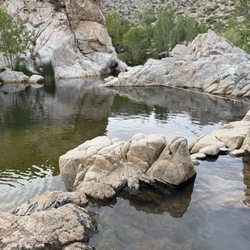
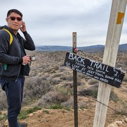
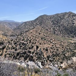
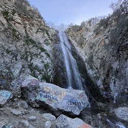
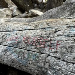
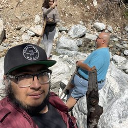
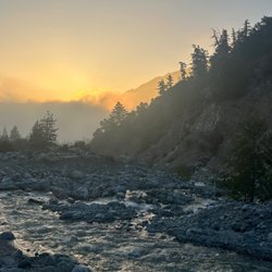
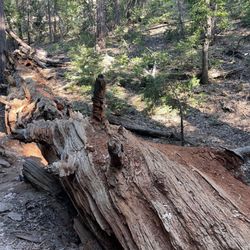
The PCT is broken into sections categorized by alphabet. I believe section 7 is actually section C. Section C of the PCT spans roughly 127.6 miles with a varying elevation gain. Parts of Section C are closed due to wildfire damage or other obstructions. I was able to hike a part of this as a quick day hike on my birthday. This part of the trail is still in pretty good condition and well maintained. Even in the fire areas you could see new vegetation sprouting up. There was beauty in the ashes. I enjoyed the view of Silverwood Lake as I hiked towards 138/173. The fire area is not a huge area and easy to hike through pretty quickly. As with all of the PCT, caution is required if hiking solo, watch your step, especially with catwalks and drop-offs. This section is mainly uncovered, and it gets hot in the desert so make sure to have sufficient hydration! read more


More info about Pacific Crest Trail Section 7
17891 California 173
Hesperia, CA 92345
Directions
Hours
Outdoor Amenities
You might also consider


Pacific Crest Trail Section 7 - hiking - Updated June 2026
Best of Hesperia
People found Pacific Crest Trail Section 7 by searching for…
Hiking Trails in Hesperia, California
Things to Do in Hesperia, California
Beautiful Views in Hesperia, California
Walking Trails in Hesperia, California
Running Trails in Hesperia, California
Trails in Hesperia, California
Scenic View in Hesperia, California
Swimming Holes in Hesperia, California
Easy Hikes in Hesperia, California
Off Road Trails in Hesperia, California
Fishing Spots in Hesperia, California
Places to Take Pictures in Hesperia, California
Lakes & Ponds in Hesperia, California
Waterfall Hike in Hesperia, California
Night Hike in Hesperia, California
Nature in Hesperia, California
Swimming Lakes in Hesperia, California
Bike Paths in Hesperia, California
Urban Exploration in Hesperia, California
Kids Friendly Beaches in Hesperia, California
Parks for Kids in Hesperia, California
Trending Searches in Hesperia, CA
Black Owned Nail Salons near Pacific Crest Trail Section 7
Boat Rental near Pacific Crest Trail Section 7
Cliff Jumping near Pacific Crest Trail Section 7
Day Trips near Pacific Crest Trail Section 7
Dog Friendly Trails near Pacific Crest Trail Section 7
Fishing Spots near Pacific Crest Trail Section 7
Jet Ski Rental near Pacific Crest Trail Section 7
Kayak Rental near Pacific Crest Trail Section 7
Lakes & Ponds near Pacific Crest Trail Section 7
Off Road Trails near Pacific Crest Trail Section 7
Outdoor Activities near Pacific Crest Trail Section 7
Places To Walk Around near Pacific Crest Trail Section 7
Public Pools near Pacific Crest Trail Section 7
Public Shower near Pacific Crest Trail Section 7
River Swimming near Pacific Crest Trail Section 7
Rock Quarry near Pacific Crest Trail Section 7
Scenic Night View near Pacific Crest Trail Section 7
Scenic Overlook near Pacific Crest Trail Section 7
Secluded Spots near Pacific Crest Trail Section 7
Soccer Store near Pacific Crest Trail Section 7
Splash Pad near Pacific Crest Trail Section 7
Strawberry Picking near Pacific Crest Trail Section 7
Sunrise View near Pacific Crest Trail Section 7
Swimming Holes near Pacific Crest Trail Section 7
Swimming Lakes near Pacific Crest Trail Section 7
U Pick Farms near Pacific Crest Trail Section 7
Watch Sunset near Pacific Crest Trail Section 7
Browse Articles
Browse Nearby
Browse Brands
Related Searches in Hesperia, CA
Affordable Kayak Rental Services in Hesperia, California
Best Fishing Locations and Guides in Hesperia, California
Best Nature Trails for Hiking in Hesperia, California
Best Places for Horseback Riding in Hesperia, California
Best Sledding Spots and Fun in Hesperia, California
Best Waterfalls and Swimming Holes in Hesperia, California
Check Out Off Road Trails in Hesperia, California
Discover Dog Friendly Trails to Explore in Hesperia, California
Discover Kid Friendly Hiking Trails in Hesperia, California
Discover Scenic Mountain Bike Trails Near Hesperia, California
Discover Scenic Waterfall Spots in Hesperia, California
Discover Top Nature Parks to Visit in Hesperia, California
Discover Walking Parks in Hesperia, California Near You
Discover a Hiking Trail in Hesperia, California
Discover the Best Night Hike Trails in Hesperia, California
Discover the Best Running Track in Hesperia, California
Dog-Friendly Hikes With Dogs in Hesperia, California
Enjoy Camping Adventures Around Hesperia, California
Enjoy Exciting Mountain Biking Adventures in Hesperia, California
Enjoy Kayaking Adventures in Hesperia, California
Enjoy Tent Camping Spots Around Hesperia, California
Enjoy a Beautiful Waterfall Hike in Hesperia, California
Enjoy the Best Picnic Spots and Ideas in Hesperia, California
Enjoy the Best Tubing Experiences in Hesperia, California
Enjoy the Best Walking Path in Hesperia, California
Enjoy the Best Walking Trails in Hesperia, California
Exciting Cliff Jumping Spots in Hesperia, California
Explore Beautiful Parks and Green Spaces in Hesperia, California
Explore Easy Hikes Perfect for All in Hesperia, California
Explore Fun Activities to Do in Hesperia, California
Explore Popular Campgrounds Near Hesperia, California
Explore Top Dog Parks in Hesperia, California Near You
Explore the Best Beach Spots in Hesperia, California
Explore the Best Swimming Holes Around Hesperia, California
Explore the Best Trail Options in Hesperia, California
Find Popular Ziplining Spots Around Hesperia, California
Find the Best Parks for Picnics in Hesperia, California
Hiking Trails With Waterfalls in Hesperia, California
Off Leash Dog Hiking Trails in Hesperia, California
Plan a Scenic Drive Route Near Hesperia, California
Popular Fishing Spots to Explore in Hesperia, California
Popular Outdoor Activities to Try in Hesperia, California
Popular Picnic Spots to Visit in Hesperia, California
Safe River Swimming Areas in Hesperia, California
Safe and Fun Parks for Kids in Hesperia, California
Top Climbing Spots and Gyms in Hesperia, California
Top Running Trails to Explore in Hesperia, California
Top Swimming Lakes to Enjoy in Hesperia, California
People who viewed Pacific Crest Trail Section 7 also viewed
Rainbow Bridge Via Pacific Crest Trail
4 reviews
Blue Ridge Trail
15 reviews
Mojave Riverwalk Trailhead
7 reviews
Mormon Rocks Interpretive Trail
8 reviews
Horseman's BMX
6 reviews
Apple Valley River Walk
11 reviews
Indian Rock Camp
4 reviews
Mojave Riverbed
4 reviews
Mojave River Forks Campground
13 reviews
Cougar Crest Trail
79 reviews