Indian Rock Camp Photos


You might also consider
More like Indian Rock Camp
Recommended Reviews - Indian Rock Camp
Start your review...

4 years ago
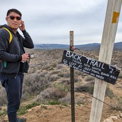
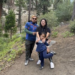
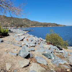
Great little hike with some shade for the family. Park by the Metate Trailhead sign and cross the road to where trail begins. According to AllTrails the hike is called Metate Trail and is approximately 2 miles of fairly flat trails. There are many different trails that links to this so you can extend your hike and go a totally different way. The Indian Rock Camp is only about 1/4 mile into the trail if you take the entrance on the left that says "interpretative." Once you get to the sign you will need to explore the hill for the Rock Camp. Our kids had a blast exploring and looking for acorns to play with. There is also a small hut for the kids to explore. Further down the trail is a small creek and lots more trail to explore. We saw signs of a large herd of deer so if you are quiet you maybe in for a surprise. read more


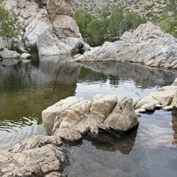
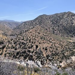
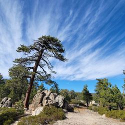
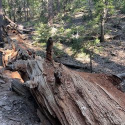
Starting at the Rock Camp Forest Service Station a very short trail (maybe a mile) winds through a beautiful grove of ponderosa pines and soon you will see a sign for the centuries (and maybe millennium) old Serrano Indian rocks that were used to grind acorns into meal for use as food. I love this place because it brings everyone back to reality, letting us know that we were not the first ones here, and we will not be the last. Its a really neat little piece of history in a secluded patch of woods. The trail head is located at 34.287955, -117.212582, just walk east and you'll run into it. I'm pretty sure there is a map and sign there as well. read more
14 years ago
13 years ago
More info about Indian Rock Camp
2294 California 173
Hesperia, CA 92345
Directions
Hours
Outdoor Amenities
You might also consider


Indian Rock Camp - hiking - Updated May 2026
Best of Hesperia
People found Indian Rock Camp by searching for…
Walking Trails in Hesperia, CA
Parks for Kids in Hesperia, CA
Running Trails in Hesperia, CA
Hiking With Kids in Hesperia, CA
Hiking Trails Kid Friendly in Hesperia, CA
Beautiful Views in Hesperia, CA
Secluded Spots in Hesperia, CA
Camping Cabins in Hesperia, CA
Fun Things to Do for a Birthday in Hesperia, CA
Trending Searches in Hesperia, CA
Bird Sanctuary near Indian Rock Camp
Botanical Gardens near Indian Rock Camp
Bounce House Rentals near Indian Rock Camp
Campgrounds near Indian Rock Camp
Cherry Picking near Indian Rock Camp
Cliff Jumping near Indian Rock Camp
Dog Friendly Trails near Indian Rock Camp
Flower Fields near Indian Rock Camp
Flower Shop near Indian Rock Camp
Garage Sales near Indian Rock Camp
Garden Center near Indian Rock Camp
Lakes & Ponds near Indian Rock Camp
Nurseries & Gardening near Indian Rock Camp
Outdoor Activities near Indian Rock Camp
Outdoor Furniture Stores near Indian Rock Camp
Party Equipment Rentals near Indian Rock Camp
Pedicure near Indian Rock Camp
Photo Spots near Indian Rock Camp
Pick Your Own Farms near Indian Rock Camp
Picnic Areas near Indian Rock Camp
Places To Take Pictures near Indian Rock Camp
Plant Nursery near Indian Rock Camp
River Swimming near Indian Rock Camp
Rock Quarry near Indian Rock Camp
Running Trails near Indian Rock Camp
Strawberry Picking near Indian Rock Camp
Sunset View near Indian Rock Camp
Browse Articles
Browse Nearby
BEST of Hesperia, California Things to Do near Indian Rock Camp
BEST of Hesperia, California Coffee near Indian Rock Camp
BEST of Hesperia, California Restaurants near Indian Rock Camp
BEST of Hesperia, California Breakfast near Indian Rock Camp
BEST of Hesperia, California Campgrounds near Indian Rock Camp
Browse Brands
Related Searches in Hesperia, CA
Affordable Kayak Rental Services in Hesperia, California
Best Fishing Locations and Guides in Hesperia, California
Best Nature Trails for Hiking in Hesperia, California
Best Places for Horseback Riding in Hesperia, California
Best Sledding Spots and Fun in Hesperia, California
Best Waterfalls and Swimming Holes in Hesperia, California
Check Out Off Road Trails in Hesperia, California
Discover Dog Friendly Trails to Explore in Hesperia, California
Discover Kid Friendly Hiking Trails in Hesperia, California
Discover Scenic Mountain Bike Trails Near Hesperia, California
Discover Scenic Walking Paths in Hesperia, California, {State}
Discover Scenic Waterfall Spots in Hesperia, California
Discover Top Nature Parks to Visit in Hesperia, California
Discover Walking Parks in Hesperia, California Near You
Discover a Hiking Trail in Hesperia, California
Discover the Best Night Hike Trails in Hesperia, California
Discover the Best Running Track in Hesperia, California
Dog-Friendly Hikes With Dogs in Hesperia, California
Enjoy Camping Adventures Around Hesperia, California
Enjoy Exciting Mountain Biking Adventures in Hesperia, California
Enjoy Kayaking Adventures in Hesperia, California
Enjoy Tent Camping Spots Around Hesperia, California
Enjoy a Beautiful Waterfall Hike in Hesperia, California
Enjoy the Best Picnic Spots and Ideas in Hesperia, California
Enjoy the Best Tubing Experiences in Hesperia, California
Enjoy the Best Walking Trails in Hesperia, California
Exciting Cliff Jumping Spots in Hesperia, California
Explore Beautiful Parks and Green Spaces in Hesperia, California
Explore Easy Hikes Perfect for All in Hesperia, California
Explore Fun Activities to Do in Hesperia, California
Explore Popular Campgrounds Near Hesperia, California
Explore Top Dog Parks in Hesperia, California Near You
Explore the Best Beach Spots in Hesperia, California
Explore the Best Swimming Holes Around Hesperia, California
Explore the Best Trail Options in Hesperia, California
Find Popular Ziplining Spots Around Hesperia, California
Find the Best Parks for Picnics in Hesperia, California
Hiking Trails With Waterfalls in Hesperia, California
Off Leash Dog Hiking Trails in Hesperia, California
Plan a Scenic Drive Route Near Hesperia, California
Popular Fishing Spots to Explore in Hesperia, California
Popular Outdoor Activities to Try in Hesperia, California
Popular Picnic Spots to Visit in Hesperia, California
Safe River Swimming Areas in Hesperia, California
Safe and Fun Parks for Kids in Hesperia, California
Top Climbing Spots and Gyms in Hesperia, California
Top Running Trails to Explore in Hesperia, California
Top Swimming Lakes to Enjoy in Hesperia, California
People who viewed Indian Rock Camp also viewed
Heart Rock
200 reviews
Butler Peak Fire Tower
2 reviews
Bertha Peak through Cougar Crest Trail
8 reviews
Strawberry Peak Fire Lookout Tower
37 reviews
Siberia Creek Trail / Champion Lodgepole Pine
7 reviews
Castle Rock Trail
248 reviews
San Bernardino Peak
14 reviews
Green Valley Campground
65 reviews
Happy Hills Trail
3 reviews
Big Horn Mine
123 reviews