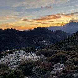
Mormon Rocks Interpretive Trail Photos


You might also consider
More like Mormon Rocks Interpretive Trail
Recommended Reviews - Mormon Rocks Interpretive Trail
Start your review...


2 years ago
The Mormon rocks are right off the 15 freeway on the 138. Large parking area to get out and stretch, let the pups out, or do some climbing. A beautiful crisp day enjoying the views of this landmark. read more
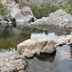
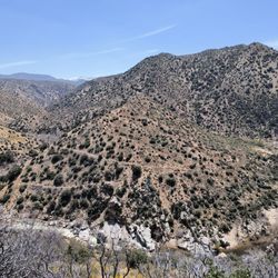
No time to hike the complete trail but there's plenty to see from the parking area with a short walk. Located along the San Andreas fault and exposed thanks to those tectonics, these sandstone blocks are exposed and climbable. The rocks received their name from Mormon settlers, moving to the Los Angeles Basin from Salt Lake City, Utah during the 1850s. There is a large parking lot at the bottom here where CA Highway 138 meets the 15 Freeway. There is no water and there is no shade. There are some great views but be prepared. And of course, always hike with a friend! [Review 17535 overall - 332 in California - 1053 of 2022.] read more

3 years ago
4 years ago
Great little hike about a mile circle. Not very challenging but you have a great view of all the beautiful rocks. You can park in the fire station and walk from there. Great way to break up a car ride from Vegas to San Diego! read more


8 years ago
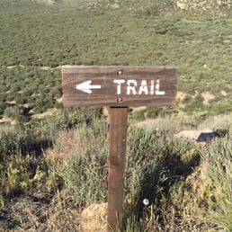
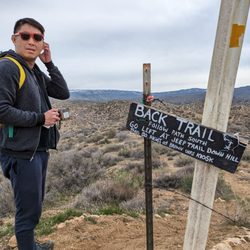
The trail begins at the Mormon Rocks fire station off the 138 West of the 15 N. Around a one mile hike. Not a lot of incline. Very simple with beautiful views of the rock formations. There are markers throughout the trail to help you go in the right direction. My friend and I were a bit adventurous and went our own way. It was still easy and we were able to find our way back in once piece. No hiking gear needed. Would recommend bringing sunblock. No shade. Free parking at the fire station. Overall I loved this trail. read more


5 years ago
More info about Mormon Rocks Interpretive Trail
Ask the Community - Mormon Rocks Interpretive Trail
You might also consider


Why does Yelp recommend reviews?
1 review that is not currently recommended
The reviews below are not factored into the business's overall star rating.
4 years ago
Mormon Rocks Interpretive Trail - hiking - Updated July 2026
Best of Phelan
People found Mormon Rocks Interpretive Trail by searching for…
Trending Searches in Phelan, CA
Black Owned Nail Salons near Mormon Rocks Interpretive Trail
Boat Rental near Mormon Rocks Interpretive Trail
Cliff Jumping near Mormon Rocks Interpretive Trail
Day Trips near Mormon Rocks Interpretive Trail
Dog Swimming near Mormon Rocks Interpretive Trail
Jet Ski Rental near Mormon Rocks Interpretive Trail
Kayak Rental near Mormon Rocks Interpretive Trail
Lakes & Ponds near Mormon Rocks Interpretive Trail
Off Road Trails near Mormon Rocks Interpretive Trail
Outdoor Activities near Mormon Rocks Interpretive Trail
Picnic Spots near Mormon Rocks Interpretive Trail
Places To Walk Around near Mormon Rocks Interpretive Trail
Public Pools near Mormon Rocks Interpretive Trail
Public Shower near Mormon Rocks Interpretive Trail
River Swimming near Mormon Rocks Interpretive Trail
River Tubing near Mormon Rocks Interpretive Trail
Rock Quarry near Mormon Rocks Interpretive Trail
Running Trails near Mormon Rocks Interpretive Trail
Scenic Night View near Mormon Rocks Interpretive Trail
Scenic Overlook near Mormon Rocks Interpretive Trail
Soccer Store near Mormon Rocks Interpretive Trail
Splash Pad near Mormon Rocks Interpretive Trail
Sunrise View near Mormon Rocks Interpretive Trail
Swimming Holes near Mormon Rocks Interpretive Trail
Swimming Lakes near Mormon Rocks Interpretive Trail
U Pick Farms near Mormon Rocks Interpretive Trail
Watch Sunset near Mormon Rocks Interpretive Trail
Browse Articles
Browse Nearby
BEST of Phelan, California Restaurants near Mormon Rocks Interpretive Trail
BEST of Phelan, California Lakes near Mormon Rocks Interpretive Trail
BEST of Phelan, California Coffee near Mormon Rocks Interpretive Trail
BEST of Phelan, California Things to Do near Mormon Rocks Interpretive Trail
BEST of Phelan, California Breakfast near Mormon Rocks Interpretive Trail
BEST of Phelan, California Campgrounds near Mormon Rocks Interpretive Trail
Browse Brands
Related Searches in Phelan, CA
Best Fishing Locations and Guides in Phelan, California
Best Nature Trails for Hiking in Phelan, California
Best Places for Horseback Riding in Phelan, California
Best Waterfalls and Swimming Holes in Phelan, California
Check Out Off Road Trails in Phelan, California
Discover Scenic Bike Paths in Phelan, California
Discover Scenic Mountain Bike Trails Near Phelan, California
Discover Scenic Waterfall Spots in Phelan, California
Discover Top Nature Parks to Visit in Phelan, California
Discover Walking Parks in Phelan, California Near You
Discover the Best Night Hike Trails in Phelan, California
Discover the Best Running Track in Phelan, California
Dog-Friendly Hikes With Dogs in Phelan, California
Enjoy Camping Adventures Around Phelan, California
Enjoy Kayaking Adventures in Phelan, California
Enjoy Tent Camping Spots Around Phelan, California
Enjoy a Beautiful Waterfall Hike in Phelan, California
Enjoy the Best Picnic Spots and Ideas in Phelan, California
Enjoy the Best Tubing Experiences in Phelan, California
Enjoy the Best Walking Path in Phelan, California
Enjoy the Best Walking Trails in Phelan, California
Exciting Cliff Jumping Spots in Phelan, California
Explore Beautiful Parks and Green Spaces in Phelan, California
Explore Fun Activities to Do in Phelan, California
Explore Popular Campgrounds Near Phelan, California
Explore Scenic Lakes to Visit in Phelan, California
Explore Top Dog Parks in Phelan, California Near You
Explore the Best Swimming Holes Around Phelan, California
Find Beautiful Views in Phelan, California
Find Parks and Recreation Activities in Phelan, California
Find Popular Ziplining Spots Around Phelan, California
Find the Best Parks for Picnics in Phelan, California
Find the Best Playgrounds to Visit in Phelan, California
Find the Best Scenic View Locations in Phelan, California
Great Places to Walk in Phelan, California
Hiking Trails With Waterfalls in Phelan, California
Plan a Scenic Drive Route Near Phelan, California
Popular Fishing Spots to Explore in Phelan, California
Popular Outdoor Activities to Try in Phelan, California
Safe River Swimming Areas in Phelan, California
Safe and Fun Parks for Kids in Phelan, California
Top Climbing Spots and Gyms in Phelan, California
Top Paddleboarding Activities in Phelan, California
Top Places for Snorkeling in Phelan, California
Top Playgrounds for Kids to Enjoy in Phelan, California
Top Running Trails to Explore in Phelan, California
Top Swimming Lakes to Enjoy in Phelan, California
Top Swimming Spots and Pools in Phelan, California