Cleghorn Ridge Trail Photos


You might also consider
More like Cleghorn Ridge Trail
Recommended Reviews - Cleghorn Ridge Trail
Start your review...

Reviews With Photos

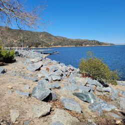
My family and I wanted to do boat paddling but the staff highly recommended kayaking and we absolutely LOVED IT! My son had such a great time he went 3 times. The lake is beautiful!!! Definitely coming back it was a work out due to high winds but we made it work. Staff was honest, fast and funny.

Cleghorn Ridge Trail is a great beginner to intermediate off-roading area with great views and the option of staying over for camping. It can be traversed in a 2 wheel-drive vehicle most times as long as it has good clearance. There are side trails and other spots where you can challenge yourself and your vehicle if you want. The trail starts at exit 129 from the 15 and heads off up the mountain into the San Bernardino National Forest. It continues about 14 miles to Silverwood Lake after climbing about 1500 feet in the first couple miles. There is a turn-off to highway 138 about 5.5 miles up if you decide you want to head off the trail early. A permit is not required if you are in a street legal vehicle and not stopping to picnic, camp, etc. Side-note: when it rains the difficulty level is higher as the steep switchbacks can get pretty slippery.


Definitely worth it for off roading. I barley discovered this trail existed. It's really fun and has many different side trails that are easy to difficult. The main trail is Easy and most of it can be done with 2wd in the summer time but I still recommend 4wd or 4x4 or AWD. The whole trail took me about 4 hours but we stopped and took pictures and also did some of the side trails. Definitely wouldn't recommend going alone in case something breaks. Take tools. Other vehicles are there off-roading so if you do go by yourself just link up with other people.

3 months ago


11 months ago
Came here during a Falken event and did some trials they did have some good ones but nothing that stood out compared to other spots I've been to. Worth checking out if its your first time out and trying to learn how to do some off roading. read more

4 years ago
My family and I wanted to do boat paddling but the staff highly recommended kayaking and we absolutely LOVED IT! My son had such a great time he went 3 times. The lake is beautiful!!! Definitely coming back it was a work out due to high winds but we made it work. Staff was honest, fast and funny. read more

4 years ago
Cleghorn Ridge Trail is a great beginner to intermediate off-roading area with great views and the option of staying over for camping. It can be traversed in a 2 wheel-drive vehicle most times as long as it has good clearance. There are side trails and other spots where you can challenge yourself and your vehicle if you want. The trail starts at exit 129 from the 15 and heads off up the mountain into the San Bernardino National Forest. It continues about 14 miles to Silverwood Lake after climbing about 1500 feet in the first couple miles. There is a turn-off to highway 138 about 5.5 miles up if you decide you want to head off the trail early. A permit is not required if you are in a street legal vehicle and not stopping to picnic, camp, etc. Side-note: when it rains the difficulty level is higher as the steep switchbacks can get pretty slippery. read more


8 years ago
Hit this trail Saturday afternoon with my brother and our quads and it was awwwwesome! Great trail, scenic and great little spots along the way to really play with your OHV. Fun trail to spend an afternoon/evening riding along and it's freeee! read more


6 years ago


6 years ago
Took my 2019 Chevy Silverado custom trail boss and had lots of fun! Trail is pretty muddy/snow right now so wouldn't suggest 2WD going right now. Needed to use 4L a lot due to sliding from all the mud/incline. But overall great trail with great view. read more


7 years ago
7 years ago
One of my favorite off-road trails .. it has a lot of different skills set offshoots and it's a very good trail to see what your comfortable with. I recommend this trail to anyone, from newbies to experienced drivers, there's something for everyone. read more

5 years ago
6 years ago
Definitely worth it for off roading. I barley discovered this trail existed. It's really fun and has many different side trails that are easy to difficult. The main trail is Easy and most of it can be done with 2wd in the summer time but I still recommend 4wd or 4x4 or AWD. The whole trail took me about 4 hours but we stopped and took pictures and also did some of the side trails. Definitely wouldn't recommend going alone in case something breaks. Take tools. Other vehicles are there off-roading so if you do go by yourself just link up with other people. read more


11 years ago
My son and I hit this trail up yesterday with our SXS for the first time. We don't have a lot of experience test but this was nice way to get some on an easy trail with a great view. I highly suggest it for anyone looking to kill a couple hours. The best part is that it's only 20 minutes from my home. read more


11 years ago
More info about Cleghorn Ridge Trail
Ask the Community - Cleghorn Ridge Trail
Hi do I need Lock differentials or a permit? to cross the trail , thanks
No you do not
I have a 3500 mega cab diesel 4x4 I would like to take my family and also get a lil mud on my tires will my rig be too big or will I be fine? I'm no stranger to off-roading being from the south but I would like to know exactly what I'm gettin into?
Stay on the main trail and you will be fine.... I have a Hummer H2 its wide had no problems
I have a 2016 Ram 1500 2wd quad cab well it make it?
Sure will stay on the main trail hahah
Review Highlights - Cleghorn Ridge Trail
You might also consider


Why does Yelp recommend reviews?
1 review that is not currently recommended
The reviews below are not factored into the business's overall star rating.
3 years ago
Cleghorn Ridge Trail - parks - Updated May 2026
Best of Phelan
People found Cleghorn Ridge Trail by searching for…
Trending Searches in Phelan, CA
Baseball Fields near Cleghorn Ridge Trail
Botanical Gardens near Cleghorn Ridge Trail
Bounce House Rentals near Cleghorn Ridge Trail
Campgrounds near Cleghorn Ridge Trail
Cherry Picking near Cleghorn Ridge Trail
Cliff Jumping near Cleghorn Ridge Trail
Dog Friendly Things To Do near Cleghorn Ridge Trail
Fishing Spots near Cleghorn Ridge Trail
Flower Shop near Cleghorn Ridge Trail
Garage Sales near Cleghorn Ridge Trail
Garden Center near Cleghorn Ridge Trail
Hair near Cleghorn Ridge Trail
Nurseries & Gardening near Cleghorn Ridge Trail
Off Leash Dog Parks near Cleghorn Ridge Trail
Outdoor Activities near Cleghorn Ridge Trail
Outdoor Basketball Courts near Cleghorn Ridge Trail
Outdoor Furniture Stores near Cleghorn Ridge Trail
Party Equipment Rentals near Cleghorn Ridge Trail
Pedicure near Cleghorn Ridge Trail
Pick Your Own Farms near Cleghorn Ridge Trail
Picnic Areas near Cleghorn Ridge Trail
Places To Take Pictures near Cleghorn Ridge Trail
Public Running Track near Cleghorn Ridge Trail
Rock Quarry near Cleghorn Ridge Trail
Splash Pad near Cleghorn Ridge Trail
Strawberry Picking near Cleghorn Ridge Trail
Swimming Holes near Cleghorn Ridge Trail
Table And Chair Rentals near Cleghorn Ridge Trail
Browse Articles
Browse Nearby
BEST of Phelan, California Coffee near Cleghorn Ridge Trail
BEST of Phelan, California Restaurants near Cleghorn Ridge Trail
BEST of Phelan, California Breakfast near Cleghorn Ridge Trail
BEST of Phelan, California Things to Do near Cleghorn Ridge Trail
BEST of Phelan, California Campgrounds near Cleghorn Ridge Trail
BEST of Phelan, California Thrift Stores near Cleghorn Ridge Trail
Browse Brands
Related Searches in Phelan, CA
Best Nature Trails for Hiking in Phelan, California
Best Off Leash Dog Parks in Phelan, California
Best Parks for Parties and Events in Phelan, California
Check Out Great Playgrounds in Phelan, California
Discover Baseball Fields Around Phelan, California
Discover Free Parking Options in Phelan, California
Discover Lakes & Ponds to Explore in Phelan, California
Discover Popular Photo Spots in Phelan, California
Discover Scenic Bike Paths in Phelan, California
Discover Soccer Fields in Phelan, California Near You
Discover Top Nature Parks to Visit in Phelan, California
Discover Walking Parks in Phelan, California Near You
Discover the Best Beaches in Phelan, California
Enjoy the Best Picnic Spots and Ideas in Phelan, California
Enjoy the Best Walking Path in Phelan, California
Enjoy the Best Walking Trails in Phelan, California
Explore Beautiful Botanical Gardens in Phelan, California
Explore Family-Friendly Zoos and Wildlife in Phelan, California
Explore Fun Activities to Do in Phelan, California
Explore Parks With Pull Up Bars in Phelan, California
Explore Pickleball Courts in Phelan, California
Explore Popular Campgrounds Near Phelan, California
Explore Popular Picnic Areas Around Phelan, California
Explore Popular RV Parks Around Phelan, California
Explore Popular Recreation Centers Around Phelan, California
Explore Popular Scenic Views Near Phelan, California
Explore Scenic Lakes to Visit in Phelan, California
Explore Top Dog Parks in Phelan, California Near You
Explore Top Water Parks in Phelan, California Today
Find Parks and Recreation Activities in Phelan, California
Find Top Skate Parks in Phelan, California for All Skill Levels
Find a Park With BBQ Pits in Phelan, California
Find the Best Parks BBQ Grills in Phelan, California
Find the Best Parks for Picnics in Phelan, California
Have Fun at a Splash Pad in Phelan, California
Indoor Playgrounds to Explore in Phelan, California
Locate Tennis Courts Around Phelan, California
Parks With Basketball Courts for Games in Phelan, California
Play at a Splash Pad Park in Phelan, California
Popular Children Playgrounds to Visit in Phelan, California
Popular Fishing Spots to Explore in Phelan, California
Popular Outdoor Activities to Try in Phelan, California
Popular Places to Take Pictures in Phelan, California
Top Hiking Trails to Explore in Phelan, California
Top Running Trails to Explore in Phelan, California
Top Swimming Lakes to Enjoy in Phelan, California
Top-Rated Basketball Courts to Play at in Phelan, California
Visit Popular Museums in Phelan, California Now
Visit the Best Kids Play Place Options in Phelan, California
People who viewed Cleghorn Ridge Trail also viewed
Heart Rock
200 reviews
Silverwood Lake State Recreation Area
290 reviews
Horseman's BMX
6 reviews
Cucamonga Peak
110 reviews
North Etiwanda Preserve
306 reviews
Lytle Creek Ranger Station
39 reviews
Etiwanda Falls Trail
57 reviews
Big Horn Mine
123 reviews
Lytle Creek - Cajon Pass Recreation Area
2 reviews
Mojave Riverbed
4 reviews