Third Stream Falls Photos


You might also consider
More like Third Stream Falls
Recommended Reviews - Third Stream Falls
Start your review...

Reviews With Photos

We took my friend's trusty minivan out to Third Stream Falls this morning. We followed Greg A. and Jon K.'s driving and hiking directions, but got a little lost at the step where you're supposed to look for a canyon which forks to the left. The left canyon opening is quite narrow, so we ventured up the right side thinking it was the main path. Going up further, this canyon eventually divides in to two MORE canyons, so we went up THIS left path following the streambeds (thinking this was the split mentioned in previous Yelp reviews) until there was no more water left :p Upon giving up, we headed back towards the parking lot, but ultimately found the correct path due to my supersonic hearing and navigation skillz. I guess it's important to keep in mind that it's the end of summer and we're in the midst of a severe drought, so certain features may not look the same. Things to keep in mind: HOT HOT HEAT: Try to get an early start to avoid the heat. We arrived around 7:30 am before the cloud layer had burned off, but even so, it was a scorcher today. The first two miles or so, you're climbing steadily uphill and there is little to no shade. Bring more water than you think you need! Also, I feel like the bigger animals are more active earlier in the day before it gets too hot-- we saw ~10 bighorn sheep and 4 deer earlier on during our hike. INSECT REPELLENT: Those mosquitos and gnats are relentless! My friend and I must have looked like a pair of maniacs flailing our arms about while hiking, but it was all we could do. They literally bite you through your clothes, lodge themselves into your eyeballs and swarm around you as you try to outrun them. Good luck. I recommend going in the winter, especially after recent rainfall. Third Stream Falls was more of a trickle than a waterfall (which I suppose is expected), but it was beautiful regardless.

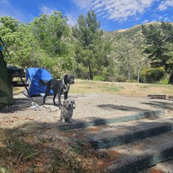
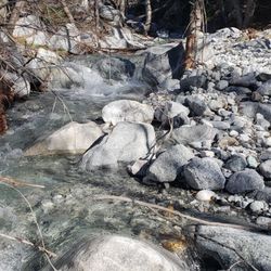
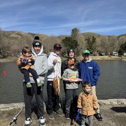
If you plan on hiking this trail you will need 4x4 to maneuver over some of the uneven terrain. Drive all the way until the fire road ends and you will find the trail head. Vault toilets available at the parking lot. Make sure you have an adventure pass. I would rate this as a moderate hike because of the incline. Bring lots of water; it can get very warm and the sun will be beating down on you. There is a fork in the trail about 1.5 miles from the trail head with the option to explore Stone House Camp. We took this trail down to the creek and explored the area. You will need to cross the creek to find the remains of Stone House Camp. There was water in the creek during November but it was easily passable. Be careful of the prickly bushes, they can cause an itchy reaction if your skin touches it. One of my kids brushed against it and he was in pain for a while. Luckily there was water in the creek to help wash off the oil or fine hairs from the plant. The trail keeps going up the canyon and parts of it were overgrown so we didn't venture far from the creek because most of us were wearing shorts. Wear pants! There were lots of bugs near the creek. So be aware and bring repellant.

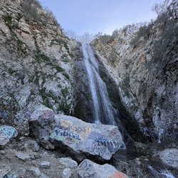
Third Stream Falls is an eighty foot waterfall located in a remote canyon in the Cucamonga Wilderness just above Rancho Cucamonga California. Unlike many of the waterfalls in Southern California, Third Stream Falls flows steadily for most of the year. I first heard about the waterfall from an excellent book called The Definitive Guide to the Waterfalls of Southern and Central California written by Chris Shaffer. I've been using his book for 2 years and I've visited nearly every waterfall in Riverside, Orange, and Las Angeles County. Third Stream Falls is, without a doubt, my favorite waterfall in Southern California. We didn't see a single other person on the trail, and the noise from the outside world is literally non-existent. My girlfriend and I had been saving this waterfall for a day when the temperatures in the mountain were at least in the fifties. We've learned the hard way that temperatures at higher elevations in southern California often vary by as much as 40 degrees. We both bring a jacket and a fleece sweatshirt on every mountain hike we attempt. From route 15, take the Sierra exit just north of the city of Fontana. Turn left on Sierra road and drive 6 miles. Turn left onto Middle Fork Road and drive for another 3 miles until the end. The trail to the waterfall starts in a parking lot at the end of Middle Fork Road. I was extremely surprised to see that the parking lot had its own bathroom because Middle Fork road was in poor condition. We did fine in a Toyota Camry, but I wouldn't take my Lamborghini down that road. From the parking lot, you climb steadily up the right side of the canyon for 2 miles. You get fantastic views of the cascading river below you. At about two miles in, you come into a giant grove of redwoods, many of which were severely burned in a fire several years ago. We crossed several dry streambeds which were tributaries of Lytle Creek as well as a few very primitive looking campsites which I've heard the boyscouts use and a large wooden sign for the Cucamonga Wilderness. After hiking through the redwood grove for about half a mile, the narrow canyon opens up into a giant bowl. This is where you cross Lytle Creek and head for the canyon on the left side of the river with the cascading water flowing out of it. The mouth of this side canyon is at least 30 feet wide with walls over a hundred feet tall. If you are looking for it, you won't be able to miss it. The side canyon is very steep and you will have to do some minor rock scrambling to get to the waterfall. The path is visible, but you will probably end up stepping in the water a few times. After a quarter mile, the waterfall will come into view. It's a two tiered waterfall totaling about a hundred feet tall with a decent swimming hole at its base. The water at the base was so cold that I could barely stick my toe into it, but it was crystal clear and very tempting to take a dip. If I do this hike again in the summer, I'm definitely going swimming. We ate lunch at the waterfall, took a few a pictures and then headed back to the parking lot the same way we came in. Coming out took us half the time it took us coming in. Although it's only a 6 mile roundtrip hike, it took us almost 3 hours to do the whole thing because of the steep elevation gain on the way in. You can check out more hikes at my blog http://southcaladventures.blogspot.com/

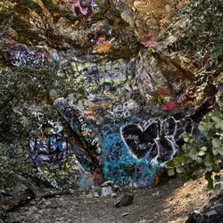
First of all not sure why but my directions showed I arrived at my destination just past the last house on the right. So I parked. Unfortunately, I was approx. 2.5 miles too soon. Luckily it was a wide fire trail but it was pretty intense!!! Keep driving until the fire road ends. There is parking and a bathroom as well. It's been recently maintained with what looks like fresh gravel. No 4x4 needed. On my way up I was appalled at the graffiti! It's disturbing that punks can't respect nature and also pollute our water. Once you are on the trailhead it's a steady incline on a very narrow trail. But it's pretty well kept and it isn't overgrown much. I only took the path up to the Stone House camp, which stupidly there is no actual "stone house" also not really a camp I could find unless the camp marker was slightly off? But I don't recommend this trail one bit. The beginning of the trail is cleared and easy to hike down. But once you get to the creek it's hell from there on in and back out. The trail literally ends at the creek. I had to cross the creek a few times repeatedly. There are huge boulders and a lot of loose rocks. There are also a lot of downed trees, and don't get me started on the gnats! Plus tons of fire ants, regular house ants, and tons of spiders and spider webs! I had repellent on and the gnats were all over me 10 fold! It was hell trying to swat them away while climbing boulders, climbing over & under trees, and crossing the creek multiple times. The creek was roaring like crazy in places and a tad scary to be honest. In one crossing I lost my balance on a slimy rock and ended up in the creek. I finally decided to turn around, and nearly fell off a section of rocks that must have been part of a landslide, because when I started putting my body weight on them they tumbled down and I ended up cutting my leg on a sharp boulder. Trying to make my way out I regretted ever venturing into this mess. My advice stay on the main trail! I never did make it to the stream crossing, so maybe next time. It's all sun and it's extremely warm so bring lots of water. I did 7.25 miles and drank all my 2L water bladder. Watch out for small snakes that look like long lizards without legs. The one I saw was when I was walking back down towards my car on the fire road. There were a few homeless up there, in their cars with a forest adventure pass. I think they stay there during the day until the trail closes. So be careful. read more


This location was easy to get to for a quick snow trip. You are able to park on most sides of the road but just be careful taking off because alot of the people zoom through the two way highway. Came up on a whim early morning to enjoy the fresh snow. The drive is not too far from riverside so we love going up here spring our winter. read more


I stumbled upon the review for this hike and was immediately ready to hit the trails. It took about 3 weeks to finally get here. Three days before, I checked the weather - 50 and sunny - "Perfect".. That morning it's sprinkling when we wake up. I checked the weather again, ok well it's lightly sprinkling and is supposed to be snowing later that evening. Arrive at trail, it's SNOWING at 12 pm. We decided to trek forwarded, possibly under-prepared but trekking forward nonetheless. This is technically a short trail, attached to the much longer Middle Fork trail. We took the upper trail, and even with the gaining elevation it wasn't steep or tiring. And though it was snowing it was absolutely beautiful. Can't wait to come back in the spring. Happy Trails! read more
12 years ago
We took my friend's trusty minivan out to Third Stream Falls this morning. We followed Greg A. and Jon K.'s driving and hiking directions, but got a little lost at the step where you're supposed to look for a canyon which forks to the left. The left canyon opening is quite narrow, so we ventured up the right side thinking it was the main path. Going up further, this canyon eventually divides in to two MORE canyons, so we went up THIS left path following the streambeds (thinking this was the split mentioned in previous Yelp reviews) until there was no more water left :p Upon giving up, we headed back towards the parking lot, but ultimately found the correct path due to my supersonic hearing and navigation skillz. I guess it's important to keep in mind that it's the end of summer and we're in the midst of a severe drought, so certain features may not look the same. Things to keep in mind: HOT HOT HEAT: Try to get an early start to avoid the heat. We arrived around 7:30 am before the cloud layer had burned off, but even so, it was a scorcher today. The first two miles or so, you're climbing steadily uphill and there is little to no shade. Bring more water than you think you need! Also, I feel like the bigger animals are more active earlier in the day before it gets too hot-- we saw ~10 bighorn sheep and 4 deer earlier on during our hike. INSECT REPELLENT: Those mosquitos and gnats are relentless! My friend and I must have looked like a pair of maniacs flailing our arms about while hiking, but it was all we could do. They literally bite you through your clothes, lodge themselves into your eyeballs and swarm around you as you try to outrun them. Good luck. I recommend going in the winter, especially after recent rainfall. Third Stream Falls was more of a trickle than a waterfall (which I suppose is expected), but it was beautiful regardless. read more


6 years ago
If you plan on hiking this trail you will need 4x4 to maneuver over some of the uneven terrain. Drive all the way until the fire road ends and you will find the trail head. Vault toilets available at the parking lot. Make sure you have an adventure pass. I would rate this as a moderate hike because of the incline. Bring lots of water; it can get very warm and the sun will be beating down on you. There is a fork in the trail about 1.5 miles from the trail head with the option to explore Stone House Camp. We took this trail down to the creek and explored the area. You will need to cross the creek to find the remains of Stone House Camp. There was water in the creek during November but it was easily passable. Be careful of the prickly bushes, they can cause an itchy reaction if your skin touches it. One of my kids brushed against it and he was in pain for a while. Luckily there was water in the creek to help wash off the oil or fine hairs from the plant. The trail keeps going up the canyon and parts of it were overgrown so we didn't venture far from the creek because most of us were wearing shorts. Wear pants! There were lots of bugs near the creek. So be aware and bring repellant. read more


14 years ago
Third Stream Falls is an eighty foot waterfall located in a remote canyon in the Cucamonga Wilderness just above Rancho Cucamonga California. Unlike many of the waterfalls in Southern California, Third Stream Falls flows steadily for most of the year. I first heard about the waterfall from an excellent book called The Definitive Guide to the Waterfalls of Southern and Central California written by Chris Shaffer. I've been using his book for 2 years and I've visited nearly every waterfall in Riverside, Orange, and Las Angeles County. Third Stream Falls is, without a doubt, my favorite waterfall in Southern California. We didn't see a single other person on the trail, and the noise from the outside world is literally non-existent. My girlfriend and I had been saving this waterfall for a day when the temperatures in the mountain were at least in the fifties. We've learned the hard way that temperatures at higher elevations in southern California often vary by as much as 40 degrees. We both bring a jacket and a fleece sweatshirt on every mountain hike we attempt. From route 15, take the Sierra exit just north of the city of Fontana. Turn left on Sierra road and drive 6 miles. Turn left onto Middle Fork Road and drive for another 3 miles until the end. The trail to the waterfall starts in a parking lot at the end of Middle Fork Road. I was extremely surprised to see that the parking lot had its own bathroom because Middle Fork road was in poor condition. We did fine in a Toyota Camry, but I wouldn't take my Lamborghini down that road. From the parking lot, you climb steadily up the right side of the canyon for 2 miles. You get fantastic views of the cascading river below you. At about two miles in, you come into a giant grove of redwoods, many of which were severely burned in a fire several years ago. We crossed several dry streambeds which were tributaries of Lytle Creek as well as a few very primitive looking campsites which I've heard the boyscouts use and a large wooden sign for the Cucamonga Wilderness. After hiking through the redwood grove for about half a mile, the narrow canyon opens up into a giant bowl. This is where you cross Lytle Creek and head for the canyon on the left side of the river with the cascading water flowing out of it. The mouth of this side canyon is at least 30 feet wide with walls over a hundred feet tall. If you are looking for it, you won't be able to miss it. The side canyon is very steep and you will have to do some minor rock scrambling to get to the waterfall. The path is visible, but you will probably end up stepping in the water a few times. After a quarter mile, the waterfall will come into view. It's a two tiered waterfall totaling about a hundred feet tall with a decent swimming hole at its base. The water at the base was so cold that I could barely stick my toe into it, but it was crystal clear and very tempting to take a dip. If I do this hike again in the summer, I'm definitely going swimming. We ate lunch at the waterfall, took a few a pictures and then headed back to the parking lot the same way we came in. Coming out took us half the time it took us coming in. Although it's only a 6 mile roundtrip hike, it took us almost 3 hours to do the whole thing because of the steep elevation gain on the way in. You can check out more hikes at my blog http://southcaladventures.blogspot.com/ read more

11 years ago
Take nothing less than a 4x4 truck. Beware of the thieves who will break into your car. This is no b.s.; i actually saw and reported a wrecked Honda accord and a TRASHED Dodge ram on my exit of the trail to the SBSD and CHP.. As a matter of fact, I literally picked up the couple whose Dodge Ram had been broken into and took them to the Forest Service office (those poor people had called 911 and waited 1 hour before hiking it out with ZERO response from the county/local EMS)... No way would i let someone hiking a three mile road in 100°+ heat continue on without help. My truck was the only one which hadn't been vandalised (probably because of the massive Browning Rifle windshield shade I had). Long story short, I'm never coming back here again. Regardless of the beauty or the available animals etc... Hike/hunt at your own risk. You might end up with no way home. read more

12 years ago
13 years ago
10 years ago
More info about Third Stream Falls
Lytle Creek, CA 92358
Directions
Hours
Outdoor Amenities
Ask the Community - Third Stream Falls
How many miles is the hike to the waterfall?
Can you camp overnight in this canyon?
In this Canyon, you may camp overnight but only within the cucamonga wilderness. Stray away from streams at least a 100 ft and you'll be okay. You will need a wilderness permit, however.
You might also consider


Why does Yelp recommend reviews?
1 review that is not currently recommended
The reviews below are not factored into the business's overall star rating.
12 years ago
Third Stream Falls - hiking - Updated June 2026
Best of Lytle Creek
People found Third Stream Falls by searching for…
Swimming Holes in Lytle Creek, California
Parks in Lytle Creek, California
Hiking Trails With Waterfalls in Lytle Creek, California
River Swimming in Lytle Creek, California
Campgrounds in Lytle Creek, California
Beautiful Views in Lytle Creek, California
Things to Do in Lytle Creek, California
Places to Take Pictures in Lytle Creek, California
Off Road Trails in Lytle Creek, California
Secret Spots in Lytle Creek, California
Walking Trails in Lytle Creek, California
River in Lytle Creek, California
Redwood Forest in Lytle Creek, California
Swimming Lakes in Lytle Creek, California
Running Trails in Lytle Creek, California
Creeks in Lytle Creek, California
Tours in Lytle Creek, California
National Parks in Lytle Creek, California
Natural Hot Springs in Lytle Creek, California
Tent Camping in Lytle Creek, California
Urban Exploration in Lytle Creek, California
Free Campgrounds in Lytle Creek, California
Trending Searches in Lytle Creek, CA
Black Owned Nail Salons near Third Stream Falls
Boat Rental near Third Stream Falls
Cliff Jumping near Third Stream Falls
Creeks near Third Stream Falls
Day Trips near Third Stream Falls
Fishing Spots near Third Stream Falls
Jet Ski Rental near Third Stream Falls
Kayak Rental near Third Stream Falls
Lakes & Ponds near Third Stream Falls
Off Road Trails near Third Stream Falls
Outdoor Activities near Third Stream Falls
Places To Walk Around near Third Stream Falls
Public Shower near Third Stream Falls
River Swimming near Third Stream Falls
Rock Quarry near Third Stream Falls
Running Trails near Third Stream Falls
Scenic Night View near Third Stream Falls
Scenic Overlook near Third Stream Falls
Secluded Spots near Third Stream Falls
Soccer Store near Third Stream Falls
Splash Pad near Third Stream Falls
Strawberry Picking near Third Stream Falls
Sunrise View near Third Stream Falls
Swimming Holes near Third Stream Falls
Swimming Lakes near Third Stream Falls
U Pick Farms near Third Stream Falls
Browse Articles
Browse Nearby
BEST of Lytle Creek, California Restaurants near Third Stream Falls
BEST of Lytle Creek, California Photo Spots near Third Stream Falls
BEST of Lytle Creek, California Things to Do near Third Stream Falls
BEST of Lytle Creek, California Parks near Third Stream Falls
BEST of Lytle Creek, California Coffee near Third Stream Falls
BEST of Lytle Creek, California Hot Springs near Third Stream Falls
BEST of Lytle Creek, California Breakfast near Third Stream Falls
BEST of Lytle Creek, California Sledding near Third Stream Falls
BEST of Lytle Creek, California Campgrounds near Third Stream Falls
Browse Brands
Related Searches in Lytle Creek, CA
Best Fishing Locations and Guides in Lytle Creek, California
Best Fun Things to Do in Lytle Creek, California
Best Nature Trails for Hiking in Lytle Creek, California
Best Places for Horseback Riding in Lytle Creek, California
Best Sledding Spots and Fun in Lytle Creek, California
Best Spots for Star Gazing in Lytle Creek, California
Best Waterfalls and Swimming Holes in Lytle Creek, California
Check Out Off Road Trails in Lytle Creek, California
Discover Dog Friendly Trails to Explore in Lytle Creek, California
Discover Popular Bike Trails in Lytle Creek, California
Discover Popular Photo Spots in Lytle Creek, California
Discover a Hiking Trail in Lytle Creek, California
Discover the Best Night Hike Trails in Lytle Creek, California
Dog-Friendly Hikes With Dogs in Lytle Creek, California
Enjoy Camping Adventures Around Lytle Creek, California
Enjoy Scenic Night View Experiences in Lytle Creek, California
Enjoy Tent Camping Spots Around Lytle Creek, California
Enjoy a Beautiful Waterfall Hike in Lytle Creek, California
Enjoy the Best Picnic Spots and Ideas in Lytle Creek, California
Enjoy the Best Walking Trails in Lytle Creek, California
Exciting Cliff Jumping Spots in Lytle Creek, California
Explore Beautiful Parks and Green Spaces in Lytle Creek, California
Explore Easy Hikes Perfect for All in Lytle Creek, California
Explore Popular Campgrounds Near Lytle Creek, California
Explore Popular RV Parks Around Lytle Creek, California
Explore Popular Scenic Overlook Points in Lytle Creek, California
Explore Scenic Lakes to Visit in Lytle Creek, California
Explore Secret Spots Worth Visiting in Lytle Creek, California
Explore the Best Swimming Holes Around Lytle Creek, California
Explore the Best Trail Options in Lytle Creek, California
Family Friendly Hiking With Kids in Lytle Creek, California
Find Popular Ziplining Spots Around Lytle Creek, California
Find Top Skate Parks in Lytle Creek, California for All Skill Levels
Find the Best Swimming Pools in Lytle Creek, California Today
Have Fun at a Splash Pad in Lytle Creek, California
Hiking Trails With Waterfalls in Lytle Creek, California
Off Leash Dog Hiking Trails in Lytle Creek, California
Perfect Spots to Watch Sunset in Lytle Creek, California
Picnic Areas With BBQ Pits Available in Lytle Creek, California
Plan a Scenic Drive Route Near Lytle Creek, California
Popular Fishing Spots to Explore in Lytle Creek, California
Popular Kids Activities in Lytle Creek, California
Popular Picnic Spots to Visit in Lytle Creek, California
Popular Places to Take Pictures in Lytle Creek, California
Popular Things to Do in Lytle Creek, California
Relax at Natural Hot Springs Near Lytle Creek, California
Safe River Swimming Areas in Lytle Creek, California
Safe and Fun Parks for Kids in Lytle Creek, California
People who viewed Third Stream Falls also viewed
San Antonio Falls
66 reviews
Cucamonga Peak
109 reviews
Lytle Creek Ranger Station
39 reviews
Stoddard Canyon Falls
33 reviews
Big Horn Mine
123 reviews
Ice House Canyon Trail
129 reviews
West Fork Trail
31 reviews
Bridge to Nowhere
5 reviews
Lytle Creek - Cajon Pass Recreation Area
3 reviews
Etiwanda Falls Trail
58 reviews