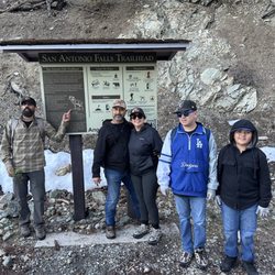
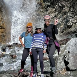
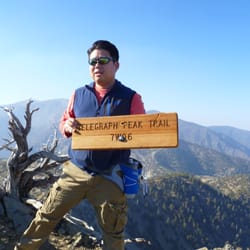
Telegragh Peak Photos


You might also consider
More like Telegragh Peak
Recommended Reviews - Telegragh Peak
Start your review...

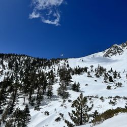
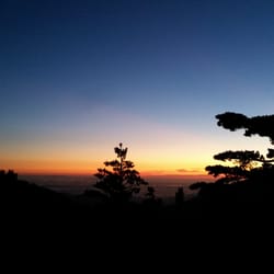
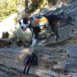
This has been my longest Mt. Baldy trail hike. The Three Tees Trail took me 16 miles, up 4,000 Feet of elevation gain and over Timber Mountain, Telegraph Peak and Thunder Mountain. And of course, to get there, I had to get up the Icehouse Canyon Trail. http://www.yelp.com/biz/ice-house-canyon-trail-mount-baldy#hrid:7xbAkpMLb89keNbcDHgMRA/src:self Since I hike with my pooch Sammy and our hike was in August, we were at the Ice House Canyon Trailhead by 4am... to avoid the heat on the climb up. This is a long hike, so even on our descent down in the heat I had to make sure I gave Sammy enough water and breaks so she wouldn't overheat. At 3.6 miles and 2,660 feet of elevation gain from the trailhead, we reached the Ice House Saddle before sunrise, took a break then headed up the Three Tees trail as the sun was rising. The trail starts up an incline right away and passes by some Manzanita bushes and some unique fallen trees. On the main trail at 4.4 miles there is a 'Timber Mountain .25' sign. Head east up the hill 0.25 miles to reach your first T, Timber Mountain at 8,303 feet. Sign the register located inside the metal cylinder, mounted in the tree, just behind the top Timber Mt. sign. Wander around behind and to the left of that tree to see a large hollowed out and twisted fallen tree. From that tree I was tempted to just head north to reconnect with the 3 T Trail, but Sammy advised me otherwise. We have gotten lost (oops, I mean detoured) before and today was not a good day for that! So, we headed back down the same way we went up. When you reach the main 3 T Trail, continue north for 2 miles towards the second T, Telegraph Peak. At first the trail goes downhill for about a half of a mile, but then at 5.5 miles, it starts UP through some narrow leg scratching Manzanita bushes and some STEEP soft dirt switchbacks through the large trees. Off to the west are some amazing views! At one point, the dirt trail seems to end at the edge of the mountain and you find yourself having to scramble up and over the large rocky boulders. At 6.99 miles, you will come across a 'Three Tees Trail' sign. For some reason there is no Telegraph Peak trail sign here. But go to the right and head up the hill for 0.2 miles to reach the Telegraph Peak at 8,985 feet. Look for the aluminum register box and the Geological Survey Bench Marker embedded in the large rock. http://www.yelp.com/user_local_photos?select=pyCsV4-lTSAaVzBIRS3m9A&userid=RoGuDu1egfAvVgb4WmZwUw Look north and you will see the Mt Baldy Notch water reservoir and the ski lodge. After Sammy and I enjoyed the amazing view, we headed back down to the main 3 T Trail and headed north again to reach our third T, Thunder Mountain... all downhill for 1.2 miles. On the way at 7.0 miles, start looking 310 degrees North West to see the green roofed San Antonio Ski Hut. It will be small, so you have to look hard for it. On the slightest of fog days you will not see it. At 8.0 miles you reach a purple 'Three T's Trail - Cucamonga Wilderness' sign and the third T, Thunder Mountain at 8,587 feet. Look over the ridge and you will see the water reservoir and the ski lodge again. Here at Thunder Mountain you can continue towards the ski lodge for 1.5 miles to make this a looped hike, but then you have to hike down the road back to your car. I didn't want to hike a road, so I just turned around after Thunder Mt. and went back the same way I got there, making this a very long 16 mile hike! In my other hiking reviews I have written about what I take, this time I will cover how I prepare my pooch Sammy for these long mountain hikes. She is a black 70 pound LOVEABLE Pit Bull. First, I feed her a high protein dog food diet. She carries her own one liter water backpack, which I mix in some pet electrolytes for the hotter days. She usually drinks more than 1 liter, so I make sure to carry extra water for her. Some days we start our hike before sunrise to avoid the heat. On those days I put my red flashing bicycle light on her backpack so I won't lose her in the mountains. On the very cold days, I put her Hurtta Pro winter fleece and wind resistant jacket on and carry her Ultra Paws 'Rugged' boots and boot liners (which help putting her boots on easier) just in case the trails get too snowy or icy. Here she is in her gear getting ready for the Devil's Backbone. http://www.yelp.com/user_local_photos?select=O-Qs4DorsTDq847jcaY6Xw&userid=RoGuDu1egfAvVgb4WmZwUw I really like the cold winter gear I bought for Sammy at www.TheDogOutdoors.com. They even posted her pictures on their facebook. https://www.facebook.com/media/set/?set=a.704051822952592.1073741829.114967671861013&type=1 I love hiking with my pooch Sammy. And I try my best to make it enjoyable and safe for her! read more


11 years ago
More info about Telegragh Peak
6777 Mt Baldy Rd
Mount Baldy, CA 91759
Directions
(909) 982-2829
Call Now
Hours
Outdoor Amenities
You might also consider


Telegragh Peak - hiking - Updated June 2026
Best of Mount Baldy
People found Telegragh Peak by searching for…
Parks in Mount Baldy, California
Things to Do in Mount Baldy, California
Off Road Trails in Mount Baldy, California
Sunrise View in Mount Baldy, California
Hiking Trails in Mount Baldy, California
Lakes & Ponds in Mount Baldy, California
Lookout Points in Mount Baldy, California
Walking Trails in Mount Baldy, California
View Points in Mount Baldy, California
Sunrise Hike in Mount Baldy, California
Swimming Holes in Mount Baldy, California
Canyoneering in Mount Baldy, California
Scenic Views in Mount Baldy, California
Full Moon Hike in Mount Baldy, California
Places to Take Pictures in Mount Baldy, California
Parks With Lakes in Mount Baldy, California
Beautiful Views in Mount Baldy, California
Picnic Areas in Mount Baldy, California
Caves in Mount Baldy, California
Swimming Lakes in Mount Baldy, California
Trail in Mount Baldy, California
Watch Sunset in Mount Baldy, California
Browse Nearby
BEST of Mount Baldy, California Restaurants near Telegragh Peak
BEST of Mount Baldy, California Coffee near Telegragh Peak
BEST of Mount Baldy, California Things to Do near Telegragh Peak
BEST of Mount Baldy, California Breakfast near Telegragh Peak
BEST of Mount Baldy, California Fishing near Telegragh Peak
BEST of Mount Baldy, California Shopping near Telegragh Peak
BEST of Mount Baldy, California Campgrounds near Telegragh Peak
BEST of Mount Baldy, California Snow Tubing near Telegragh Peak