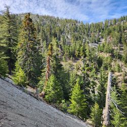
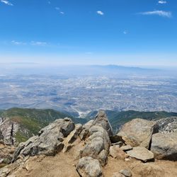
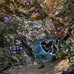
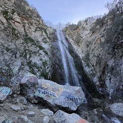
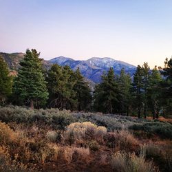
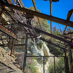
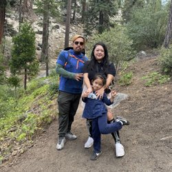
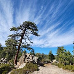
Devil's Backbone Photos


You might also consider
More like Devil's Backbone
Recommended Reviews - Devil's Backbone
Start your review...

Reviews With Photos

I summited Mt. Baldy via Devil's Backbone and it was an amazing experience! Not only were the trails easy to find and clearly marked, the people that were also hiking on the trail were super friendly. There is not much social distancing done on the hiking trails or at the summit as most people are just exhausted from the summit. This is a strenuous trail that I would not recommend for small children, but the views cannot be beat. If you are trying to work on the SoCal "6 Pack" of mountains for Mt. Whitney, this is a great option to practice on. Make sure to walk from the parking lot all the way up via Devil's Backbone and take the same trail back for a nice 14 mile hike. Make sure you have enough water and some good shoes/socks along with snacks. I ended up giving a little apple sauce packet to another hiker on the way down because she was exhausted on the side of the trail and needed something to help her. Remember that quick sugars are better than complex sugars. Candy bars are not as good as fruit (but energy gels are an even better option than fruit).

This is a pretty rough hike. The incline or decline is quite steep! Along Mount Baldy, the sign pointing to the Devil's Backbone was 1.2 miles... so I went on the trail just to check it out. I believe I have gone a bit too far in... maybe about 3 miles, so I had to hike back up to Baldy. It was tough with the nice incline. There was no sign indicating location until I bumped into a couple hunters. Luckily they didn't mistake me for a bear! Haha. Nice guys though as we spoke on the trail. They said that I was the only daring hiker to be around there... which I didn't have a clue. They asked if I was armed. No, I was not. Haha. They said the area going towards Lytle Creek is known for bears and deers. That kind of got me worried. So rushed back to the Baldy side. Overall, it's a beautiful hike. Lots of rocks and whisking grasshopper jumping around. I felt vulnerable and might have been prey. LOL. The views facing Lytle Creek was spectacular. The Pine Trees there was dropping Pine Cones. Would I do it again? My answer is yes. Just not alone.

The hike can be tough, but it's definitely not impossible. Difficulty is all relative, I felt that the hike was moderate (I did take the lift up, which cut out about 2.3 miles). Also, we went on a beautiful cool summer day, so there was no snow or ice on the mountains. Personally I felt that the toughest part was the air becoming thinner. However, once I started my rhythmic breathing and kept a steady pace I was ok. I would say that the hike is definitely not for beginners, hiking boots and poles are optional but strongly recommended. Soon after you start the the hike by the notch, you encounter a very steep climb. Not too worry, this is probably one of the steepest parts of the hike! The last steep climb are the final ascent to the peak which can be done, slow and steady! There are gorgeous views of the skyline and surrounding mountain tops as you climb. The actual devil's backbone ridge is quite picturesque. You will definitely have a great sense of accomplishment and awe when you reach the top. The weather on a summary day will be just right, a cool of 70 with a breeze. However, if you go in spring or fall it will be very windy and cold. As many people have mentioned, if you are a beginner: Go in a group and go at your pace. If you run, bike, or do other cardio it will help when you reach the higher altitudes. Lastly, don't let your friends scare you. It is a beautiful hike and definitely do-able.

What a great hike! I went up Baldy for the fourth time a few weeks ago, and enjoyed it every time! Be careful when you decide to go though, because the first time I went it was over 100 degrees, this time it was over 90 degrees, and once I went in late October and the trail was already completely snowed in so I had to turn around since I didn't have crampons on any equipment with me. My friends and I showed up to Manker Flats at 6am on a Saturday, shortly after sunrise and we really thought we were the only crazy people who would be up that early. But no, turns out there's plenty of crazy people in the world since the closest parking lot was almost full by the time we got there. We managed to snag a spot though, and immediately made use of the two portapotties that are conveniently located by the trailhead. They smell TERRIBLE but better than nothing I guess? If you're starting at Manker Flats and going up Devils Backbone and then back down the Ski Hut path, I suggest you look at this very helpful guide: https://hikingguy.com/hiking-trails/best-la-hikes/mt-baldy-hike/ He includes measurements down to the tenth mile mark and includes really helpful pictures so that you know what you're looking for! If you're going up the opposite way (through the Ski Hut first), the turnoff to the Ski Hut is a little steep and you really need to keep an eye out for it on your left hand side about a mile into the hike from the trailhead. We ended up going up and down Devils Backbone since that way we passed the Ski Lodge (different from the Ski Hut!) both times. It makes a really nice breaking point. It wasn't open when we passed it on our way up, but they leave the doors to the bathroom and water fountain open, which was really nice to use. On the way down, we were able to grab a cold drink and a small snack which felt great! Just a note re dogs... I brought three dogs up with us the last time I did it, and I don't think I'll ever do that again. One of my friends was a little slow so we didn't finish anywhere near as fast as I thought we did, so we ended up hitting 90 degree heat which made the dogs really suffer. However everyone on the hike was really friendly and nice about the dogs, and they were a hit at the summit!

My 666th review fittingly goes to... Devil's Backbone! Devil's Backbone is a trail that stretches along the ridge of the mountain east of the Mt. Baldy summit. This trail boasts some of the most spectacular views in the Mt. Baldy area. At times, you are hiking on the ridge top where to the left and right of you are steep mountain slopes (http://www.yelp.com/biz_photos/devils-backbone-mount-baldy?select=b11nnmpMhdk25XoWh3ssiA#b11nnmpMhdk25XoWh3ssiA). Don't look down if you have a fear of heights, although I am not sure you should be here in the first place if you do cuz it's pretty extreme! From jaw dropping views of the Baldy Bowl (http://www.yelp.com/biz_photos/devils-backbone-mount-baldy?select=ASVFWNHhH6lFOk96TGWsaw#ASVFWNHhH6lFOk96TGWsaw) to the 10,064 ft. peak of Old Baldy, hiking to the summit via Devil's Backbone trail is a must for any serious hiker! By distance, hiking from the Baldy Notch (where the ski lift drops you off) to the Baldy summit is just 3.2 miles, or 6.4 miles round-trip. Don't let the short distance fool you, because this is a pretty tough hike especially if you aren't used to hiking in high altitude. The first time I came here, I thought I would breeze through this hike and I got my butt handed to me. I fought altitude sickness and took over 2 hours to summit at 10,064 ft. I later found out that the hike starts at 7,802 ft. elevation which is higher than any place I had hiked at the time. By comparison, Mt. Wilson peaks out at only 5,710 ft. I had no idea how much more difficult hiking is at higher elevation! If you're a hardcore hiker, you can even start your hike way below at the San Antonio Falls/Manker Flats parking area or by the Mt. Baldy ski lifts parking lot to extend the hike even more! I would actually say that the toughest parts of the hike are the beginning and the end. The first section of the hike from the notch to the start of Devil's Backbone is slightly over a mile. This stretch is on pretty steep slope and could sap all your energy. Be sure to take enough breaks and hydrate yourself because it's a lot of work just to reach the Devil's Backbone trailhead. And the final stretch where you climb the slope to the summit is quite strenuous. I took breaks like every 5 minutes, climbing where the trails weren't so visible in the snow. This last part before summiting probably took me an hour! All in all, a breathtaking trail both literally and figuratively; did you know it's much harder to breathe in the thin air at high altitude? For those who plan to come here in the winter or when there is snow/ice, I would highly recommend you bring traction device for your boots like microspikes or crampons. On the Devil's Backbone, one slip could mean a one way ticket to... hell...?

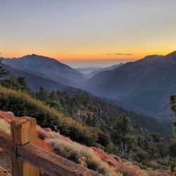
IN HONOR OF NATIONAL TRIALS DAY, June 7, 2014!!! BACKGROUND: In the United States, National Trails Day® (NTD) is the American Hiking Society's trail awareness program. Each year events are held to help promote awareness of the wide variety of benefits that trails provide, to encourage people to discover their local trails, to raise awareness of trail issues, and to instill excitement for the outdoors. National Trails Day ® is held every year on the first Saturday in June, although some local events could be held on other dates. Every year on National Trails Day The Crew hikes to the top of Mt. Baldy starting from various trail heads; Register Ridge, Ski Hut, Ice House Canyon, Devils Backbone, and Bear Flat, all with varying degrees difficulty. Know your limits. Mount San Antonio, commonly known as Mount Baldy, at 10,068 ft (3,069 m), is the highest peak in the San Gabriel Mountains, and the highest point in Los Angeles County. Mount San Antonio's sometimes snow-capped peaks are visible on clear days and dominate the view of the Los Angeles skyline. STEP OFF: This is a throwback review in honor of this celebration, show appreciation for, and lovingly give back to the hiking trails we so often take for granted. STATS: Distance: 6.6 miles Elevation Gain: 2,350ft. Max elevation: 10,064 ft. Not for beginners WARNING: Be aware of changes to your body, altitude sickness is possible http://en.wikipedia.org/wiki/Altitude_sickness http://www.huffingtonpost.com/2013/01/22/dominic-belletti-dead_n_2527345.html ESSENTIALS: Hiking shoes with good lug soles Water Layered clothing Hiking Poles Layers, it gets quite windy at the top Snacks Camera Sun screen (UV rays are stronger at 10,000+ft.) Hat (optional) Money (cash or credit) OUR ROUTE: Summiting Mt. Baldy took a while to get onto my "to do list". After over a year of hemming and hawing, I finally, in 2011, gave into its calling. I was not thrilled the first time, or the second, third, fourth, and fifth time. Sure the 360 degree view from the top is quite breathtaking, but it's mostly a trail hike. There are multiple ways to reach the peak of Baldy, and on National Trails Day 2013, I took the trail most traveled, yet shortest distance, the Devil's Backbone Trail. Round-trip ski lift tickets can be purchased at the ski lift, parking lot. The ride up to the Notch at the crack of dawn, even in June, is quite chilly, so bring layers. Jumpin' off at the top, outside the doors of The Notch, is where our hike began. The Devil's Backbone is a typical ridge-top trail that offers views on either side of the trail, with some unstable rock climbing and scree that offers breathtaking views, as well as getting the heart pumping for those afraid of heights. If you checked out the link above, hiking Mt. Baldy from any starting point can be dangerous, even deadly, so take great care while hiking and don't hike alone. The narrow trail gives way to a steep slope of scree. Cross a forest of sparse pines to a saddle between Mt. Baldy and Mt. Harwood. The steepest section of the trails is covered in 0.7 miles of switchbacks. As we climbed, we could see in the distance, Mount San Gorgonio to the east and Mount San Jacinto to the southeast. Once at the top pictures were taken, food was shared, and some even took a nap. After our break at the top we headed back the same way to The Notch. The 0.7 miles to the saddle between Mt. Baldy and Mt. Harwood was a slippery slope of loose gravel. Finally, The Notch, a restaurant at the top of the ski lifts that offers food, beverage (kid friendly, as well as adult friendly) souvenirs, and clothing. Also, I believe, but not certain, lockers for skiers during the winter months. This was supposed to be a one and done for me, yet, I've hiked to the top of Mt. Baldy seven times. This year I will be celebrating National Trails Day elsewhere, not because of my dislike for Baldy, it just didn't work out this year. I'm sure I'll be back next year. My dislike for trail hikes knocks this one down a star. DISCLAIMER: Hiking is not something that can be taken lightly. It can be life-threatening as you see and hear on the news, people die or get lost all time. Please, if you are going to hike, never go alone and prepare for the worst, hope for the best. Remember when going for a hike, no matter how short you think it may be, always be prepared. Carry at least two liters of water for every five miles (more if the weather is warm), protein bar, nuts, and electrolytes. Wear sturdy lug sole shoes and protective clothing. Some areas the weather can change quicker than a fireman can put on his gear. It is also very important, always always always let a family member or friend know where you are going and when you expect to be back. Lastly, have fun when you hike it up. #HIKING #MtBaldy #Notforbeginners

Devil's Backbone is named as such due to the trail traversing the ridge of the mountain with essentially nothing on either side - in other words, it's elevated, like the spine, and drops down on either side. It can be used to climb up to or down from Mount Baldy. If climbing up to, it would be a strenuous hike. I have only climbed down from Baldy via this route, and although long, it's not very strenuous. It's mostly flat and downhill. It will lead to the Baldy Notch, where the ski lift is located. From here, you can choose to ride the lift down or hike another 3 miles down to Manker Flats. The scenery is quite beautiful here, as it affords 360 degree views. It's definitely worth a trip here if you are up for a challenge.

Getting an early start on the Mt. Baldy hike is the way to go. My buddy and I arrived at Manker Flat at 7:15am (I totally forgot about the Adventure Pass and luckily there was a random little shop in Baldy village that was open at 7am). I was going to have us ascend via the Ski Hut trail, but I missed the turn-off and we wound up taking the Devils Backbone Trail. I'm glad we did -- it was a much easier climb and we made it to the summit in just under 3 hours. The one tip I would advise is to stick to the RIGHT when you continue past Baldy Notch. The wide trail on the left looks tempting, but it get incredibly steep after about 100 yards. The final climb to the summit is a very rocky and switchback-laden stretch of trail. Descending via the Baldy Bowl trail while lacking trekking poles did us in. My friend and I were slippin' and slidin' for a while on some gravely patches of trail. We completed the 10.6m round trip hike in just under 6 hours Is it normal to be SUPER sore after one of these hikes? Man, my butt is still achin' -- haha.

This is an ass kicker of a hike. You will taste a bit of hell when climbing the incline and will be ready to give up multiple times, but PUSH THROUGH! By the time you're about to give up, you're already at the top. (That was me) I came here beginning of April 2015 and there were some snow caps around the trail, but not directly on it. Hiking on a weekday allowed for very empty trails, which can be a good or bad thing. If you get lost, the chances of running into people are very low. Consider coming here on a weekend so that the chances of you running into a hiker are higher if this is your first time. Taking the next step to becoming a better hiker/backpacker means pushing through the pain when you're at your worst. As it should be known, Mt. Baldy is not a hike for first timers. The dirt is very loose here, making it easy to slip off and fall if you're not careful. The huge incline with high altitude makes it easy for you to get dizzy with lack of oxygen. Please remember to always stay where you KNOW where you are (ON TRAIL.) Do NOT go off trail if you are lost. My group and I went off trail and got lost on the decline. We had to climb back up on the trail, but it was much safer than getting lost in a place that we were unfamiliar with. TIPS: Bring painkillers if needed. My legs were in an insane amount of pain along with a migraine, making it difficult to hike. I pushed myself mentally, not giving up. Remember: #NOEXCUSES. You can and will do it! Make smart decisions and always be prepared for the worst.

You're the devil in disguise (oh yes you are) This deceptively short 6.4 mile hike (round trip from the ski lift drop off) should not be taken lightly! I think the highest elevation I've hiked at before was around 8,000 ft, and the first time I did that (but with a pack), it was pretty awful to adjust to. The hike here starts at around that elevation and goes to 10,000 ft, so beginners...start those breathing exercises. The first part of the hike to reach the trailhead is pretty brutal. You do a rapid ascent that is steep and seems to go on forever. Don't be discouraged, it does level off. Eventually. My friend, a beginning hiker, started to feel dizzy and nauseous during this time. Make sure to take frequent breaks and go at your own pace if this is the case! It's not a race, but to the cross-country runners we saw on the trail - props. Compared to the first part, the actual "backbone" is pretty easy. Just don't fall off, I guess. I'd be scared shitless doing this hike in the winter with all the ice, that's for sure. Unfortunately, we did not summit due to time constraints, plus our friend was super exhausted and unwilling to do the second altitude climb that awaited to get to the peak. I'll be back to conquer you next time, and maybe I'll go from the base so I don't have to pay from the ski lift! The way back was a breeze compared to the ascent, just step carefully around those rocks. This trail was very crowded, so keep that in mind if you don't like populated trails. It seemed like for the most part, people packed out their trash. Good on you guys! Views were not the most exciting for me personally, but it is still quite nice. What's pretty awesome is that once you're done hiking, you can ring the bell at the bottom and then go immediately to the restaurant to get a side of fries along with your sense of accomplishment. After all, you deserve it :)


This Trail is about 6 miles to the summit first you have to climb up to Mt. Baldy Ski hut then on the left side you can choose whichever trail you want but most likely you'll end up crossing the Devil's Backbone on your way to the summit. So I went hiking alone here last memorial day just because.... Woke up at 6 am but i didn't get there until 7:30am since i have to do some stuffs like fixing my PC cause i woke up and it got infected... Anyways it started as a cold an a bit cloudy day and the sun rays passing trough the clouds made it really nice and dramatic as i drove up to Manker flats(this is where you park your car). As I arrive there's a lot of people getting ready to hike some are well equipped and some are kinda confused on what to wear and what to bring... Me all i have is my back pack filled with 2 lenses, camera, 4 bottles of water, knife and 3 bars of trail mix. Since i hate putting on some sunblock i always end up wearing a compression shirt cause it dries really fast!!! And off i go!!! I tried to jog the first mile just trying to get the feel of it... from the parking lot, after about 1.25 miles you will see San Antonio Falls and you can always check it out before heading up or just drop by after the strenuous hike(its just a small falls, just like god peeing on you). all trough out the hike up to the Ski hut the trail is very easy and visible cause its a wide road and not well paved but a bit better than boulders... (but i like climbing boulders)... As i reached the ski hut area i got kinda confused which trail to take(its my first time trying this trail) good thing there's a couple behind me and i waited for them and asked for directions. But when i arrived to the Ski hut there's like 3 trails on the left and more on the right side so i was like a headless chicken confused and don't know where to go!!! And then i saw an old dude and i asked him and he just told me that i can take any trails on my left cause all of them leads to Devil's backbone. (There's something about the name "Devil's back bone" that made me climb this place). Since i have just been running like 2 miles a day my legs aren't used to long distance anymore so it started to burn especially on the steep slopes its gets harder and harder but its all in the mind so i just kept going until i crossed the devil's backone!!! i like this trail so much i was running and taking pictures then back to get my camera! From the ski hut to the summit it took me another 1 and a half hour so it not a really difficult hike at all.. if i can do it anyone can!!! or maybe... I'm 500lbs and 5 ft tall!!!! Pics: http://www.yelp.com/biz_photos/oYuCj3WLdK_Rt2llCmP3ug?action_user_photos=1 http://www.yelp.com/biz_photos/oYuCj3WLdK_Rt2llCmP3ug?select=ITHXzmHwurVYRrTNTPgdww http://www.yelp.com/biz_photos/oYuCj3WLdK_Rt2llCmP3ug?select=0CeKAS4bDXEPrzocyiBF3A

4 years ago


5 years ago
I summited Mt. Baldy via Devil's Backbone and it was an amazing experience! Not only were the trails easy to find and clearly marked, the people that were also hiking on the trail were super friendly. There is not much social distancing done on the hiking trails or at the summit as most people are just exhausted from the summit. This is a strenuous trail that I would not recommend for small children, but the views cannot be beat. If you are trying to work on the SoCal "6 Pack" of mountains for Mt. Whitney, this is a great option to practice on. Make sure to walk from the parking lot all the way up via Devil's Backbone and take the same trail back for a nice 14 mile hike. Make sure you have enough water and some good shoes/socks along with snacks. I ended up giving a little apple sauce packet to another hiker on the way down because she was exhausted on the side of the trail and needed something to help her. Remember that quick sugars are better than complex sugars. Candy bars are not as good as fruit (but energy gels are an even better option than fruit). read more

 - Hiking Near Me - Mount Baldy, California")
 ***IT GETS WINDY*** - Hiking Near Me - Mount Baldy, California")
This is a pretty rough hike. The incline or decline is quite steep! Along Mount Baldy, the sign pointing to the Devil's Backbone was 1.2 miles... so I went on the trail just to check it out. I believe I have gone a bit too far in... maybe about 3 miles, so I had to hike back up to Baldy. It was tough with the nice incline. There was no sign indicating location until I bumped into a couple hunters. Luckily they didn't mistake me for a bear! Haha. Nice guys though as we spoke on the trail. They said that I was the only daring hiker to be around there... which I didn't have a clue. They asked if I was armed. No, I was not. Haha. They said the area going towards Lytle Creek is known for bears and deers. That kind of got me worried. So rushed back to the Baldy side. Overall, it's a beautiful hike. Lots of rocks and whisking grasshopper jumping around. I felt vulnerable and might have been prey. LOL. The views facing Lytle Creek was spectacular. The Pine Trees there was dropping Pine Cones. Would I do it again? My answer is yes. Just not alone. read more


11 years ago
The hike can be tough, but it's definitely not impossible. Difficulty is all relative, I felt that the hike was moderate (I did take the lift up, which cut out about 2.3 miles). Also, we went on a beautiful cool summer day, so there was no snow or ice on the mountains. Personally I felt that the toughest part was the air becoming thinner. However, once I started my rhythmic breathing and kept a steady pace I was ok. I would say that the hike is definitely not for beginners, hiking boots and poles are optional but strongly recommended. Soon after you start the the hike by the notch, you encounter a very steep climb. Not too worry, this is probably one of the steepest parts of the hike! The last steep climb are the final ascent to the peak which can be done, slow and steady! There are gorgeous views of the skyline and surrounding mountain tops as you climb. The actual devil's backbone ridge is quite picturesque. You will definitely have a great sense of accomplishment and awe when you reach the top. The weather on a summary day will be just right, a cool of 70 with a breeze. However, if you go in spring or fall it will be very windy and cold. As many people have mentioned, if you are a beginner: Go in a group and go at your pace. If you run, bike, or do other cardio it will help when you reach the higher altitudes. Lastly, don't let your friends scare you. It is a beautiful hike and definitely do-able. read more

9 years ago
What a great hike! I went up Baldy for the fourth time a few weeks ago, and enjoyed it every time! Be careful when you decide to go though, because the first time I went it was over 100 degrees, this time it was over 90 degrees, and once I went in late October and the trail was already completely snowed in so I had to turn around since I didn't have crampons on any equipment with me. My friends and I showed up to Manker Flats at 6am on a Saturday, shortly after sunrise and we really thought we were the only crazy people who would be up that early. But no, turns out there's plenty of crazy people in the world since the closest parking lot was almost full by the time we got there. We managed to snag a spot though, and immediately made use of the two portapotties that are conveniently located by the trailhead. They smell TERRIBLE but better than nothing I guess? If you're starting at Manker Flats and going up Devils Backbone and then back down the Ski Hut path, I suggest you look at this very helpful guide: https://hikingguy.com/hiking-trails/best-la-hikes/mt-baldy-hike/ He includes measurements down to the tenth mile mark and includes really helpful pictures so that you know what you're looking for! If you're going up the opposite way (through the Ski Hut first), the turnoff to the Ski Hut is a little steep and you really need to keep an eye out for it on your left hand side about a mile into the hike from the trailhead. We ended up going up and down Devils Backbone since that way we passed the Ski Lodge (different from the Ski Hut!) both times. It makes a really nice breaking point. It wasn't open when we passed it on our way up, but they leave the doors to the bathroom and water fountain open, which was really nice to use. On the way down, we were able to grab a cold drink and a small snack which felt great! Just a note re dogs... I brought three dogs up with us the last time I did it, and I don't think I'll ever do that again. One of my friends was a little slow so we didn't finish anywhere near as fast as I thought we did, so we ended up hitting 90 degree heat which made the dogs really suffer. However everyone on the hike was really friendly and nice about the dogs, and they were a hit at the summit! read more

My 666th review fittingly goes to... Devil's Backbone! Devil's Backbone is a trail that stretches along the ridge of the mountain east of the Mt. Baldy summit. This trail boasts some of the most spectacular views in the Mt. Baldy area. At times, you are hiking on the ridge top where to the left and right of you are steep mountain slopes (http://www.yelp.com/biz_photos/devils-backbone-mount-baldy?select=b11nnmpMhdk25XoWh3ssiA#b11nnmpMhdk25XoWh3ssiA). Don't look down if you have a fear of heights, although I am not sure you should be here in the first place if you do cuz it's pretty extreme! From jaw dropping views of the Baldy Bowl (http://www.yelp.com/biz_photos/devils-backbone-mount-baldy?select=ASVFWNHhH6lFOk96TGWsaw#ASVFWNHhH6lFOk96TGWsaw) to the 10,064 ft. peak of Old Baldy, hiking to the summit via Devil's Backbone trail is a must for any serious hiker! By distance, hiking from the Baldy Notch (where the ski lift drops you off) to the Baldy summit is just 3.2 miles, or 6.4 miles round-trip. Don't let the short distance fool you, because this is a pretty tough hike especially if you aren't used to hiking in high altitude. The first time I came here, I thought I would breeze through this hike and I got my butt handed to me. I fought altitude sickness and took over 2 hours to summit at 10,064 ft. I later found out that the hike starts at 7,802 ft. elevation which is higher than any place I had hiked at the time. By comparison, Mt. Wilson peaks out at only 5,710 ft. I had no idea how much more difficult hiking is at higher elevation! If you're a hardcore hiker, you can even start your hike way below at the San Antonio Falls/Manker Flats parking area or by the Mt. Baldy ski lifts parking lot to extend the hike even more! I would actually say that the toughest parts of the hike are the beginning and the end. The first section of the hike from the notch to the start of Devil's Backbone is slightly over a mile. This stretch is on pretty steep slope and could sap all your energy. Be sure to take enough breaks and hydrate yourself because it's a lot of work just to reach the Devil's Backbone trailhead. And the final stretch where you climb the slope to the summit is quite strenuous. I took breaks like every 5 minutes, climbing where the trails weren't so visible in the snow. This last part before summiting probably took me an hour! All in all, a breathtaking trail both literally and figuratively; did you know it's much harder to breathe in the thin air at high altitude? For those who plan to come here in the winter or when there is snow/ice, I would highly recommend you bring traction device for your boots like microspikes or crampons. On the Devil's Backbone, one slip could mean a one way ticket to... hell...? read more


12 years ago
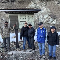
IN HONOR OF NATIONAL TRIALS DAY, June 7, 2014!!! BACKGROUND: In the United States, National Trails Day® (NTD) is the American Hiking Society's trail awareness program. Each year events are held to help promote awareness of the wide variety of benefits that trails provide, to encourage people to discover their local trails, to raise awareness of trail issues, and to instill excitement for the outdoors. National Trails Day ® is held every year on the first Saturday in June, although some local events could be held on other dates. Every year on National Trails Day The Crew hikes to the top of Mt. Baldy starting from various trail heads; Register Ridge, Ski Hut, Ice House Canyon, Devils Backbone, and Bear Flat, all with varying degrees difficulty. Know your limits. Mount San Antonio, commonly known as Mount Baldy, at 10,068 ft (3,069 m), is the highest peak in the San Gabriel Mountains, and the highest point in Los Angeles County. Mount San Antonio's sometimes snow-capped peaks are visible on clear days and dominate the view of the Los Angeles skyline. STEP OFF: This is a throwback review in honor of this celebration, show appreciation for, and lovingly give back to the hiking trails we so often take for granted. STATS: Distance: 6.6 miles Elevation Gain: 2,350ft. Max elevation: 10,064 ft. Not for beginners WARNING: Be aware of changes to your body, altitude sickness is possible http://en.wikipedia.org/wiki/Altitude_sickness http://www.huffingtonpost.com/2013/01/22/dominic-belletti-dead_n_2527345.html ESSENTIALS: Hiking shoes with good lug soles Water Layered clothing Hiking Poles Layers, it gets quite windy at the top Snacks Camera Sun screen (UV rays are stronger at 10,000+ft.) Hat (optional) Money (cash or credit) OUR ROUTE: Summiting Mt. Baldy took a while to get onto my "to do list". After over a year of hemming and hawing, I finally, in 2011, gave into its calling. I was not thrilled the first time, or the second, third, fourth, and fifth time. Sure the 360 degree view from the top is quite breathtaking, but it's mostly a trail hike. There are multiple ways to reach the peak of Baldy, and on National Trails Day 2013, I took the trail most traveled, yet shortest distance, the Devil's Backbone Trail. Round-trip ski lift tickets can be purchased at the ski lift, parking lot. The ride up to the Notch at the crack of dawn, even in June, is quite chilly, so bring layers. Jumpin' off at the top, outside the doors of The Notch, is where our hike began. The Devil's Backbone is a typical ridge-top trail that offers views on either side of the trail, with some unstable rock climbing and scree that offers breathtaking views, as well as getting the heart pumping for those afraid of heights. If you checked out the link above, hiking Mt. Baldy from any starting point can be dangerous, even deadly, so take great care while hiking and don't hike alone. The narrow trail gives way to a steep slope of scree. Cross a forest of sparse pines to a saddle between Mt. Baldy and Mt. Harwood. The steepest section of the trails is covered in 0.7 miles of switchbacks. As we climbed, we could see in the distance, Mount San Gorgonio to the east and Mount San Jacinto to the southeast. Once at the top pictures were taken, food was shared, and some even took a nap. After our break at the top we headed back the same way to The Notch. The 0.7 miles to the saddle between Mt. Baldy and Mt. Harwood was a slippery slope of loose gravel. Finally, The Notch, a restaurant at the top of the ski lifts that offers food, beverage (kid friendly, as well as adult friendly) souvenirs, and clothing. Also, I believe, but not certain, lockers for skiers during the winter months. This was supposed to be a one and done for me, yet, I've hiked to the top of Mt. Baldy seven times. This year I will be celebrating National Trails Day elsewhere, not because of my dislike for Baldy, it just didn't work out this year. I'm sure I'll be back next year. My dislike for trail hikes knocks this one down a star. DISCLAIMER: Hiking is not something that can be taken lightly. It can be life-threatening as you see and hear on the news, people die or get lost all time. Please, if you are going to hike, never go alone and prepare for the worst, hope for the best. Remember when going for a hike, no matter how short you think it may be, always be prepared. Carry at least two liters of water for every five miles (more if the weather is warm), protein bar, nuts, and electrolytes. Wear sturdy lug sole shoes and protective clothing. Some areas the weather can change quicker than a fireman can put on his gear. It is also very important, always always always let a family member or friend know where you are going and when you expect to be back. Lastly, have fun when you hike it up. #HIKING #MtBaldy #Notforbeginners read more


11 years ago
Devil's Backbone is named as such due to the trail traversing the ridge of the mountain with essentially nothing on either side - in other words, it's elevated, like the spine, and drops down on either side. It can be used to climb up to or down from Mount Baldy. If climbing up to, it would be a strenuous hike. I have only climbed down from Baldy via this route, and although long, it's not very strenuous. It's mostly flat and downhill. It will lead to the Baldy Notch, where the ski lift is located. From here, you can choose to ride the lift down or hike another 3 miles down to Manker Flats. The scenery is quite beautiful here, as it affords 360 degree views. It's definitely worth a trip here if you are up for a challenge. read more


11 years ago
Getting an early start on the Mt. Baldy hike is the way to go. My buddy and I arrived at Manker Flat at 7:15am (I totally forgot about the Adventure Pass and luckily there was a random little shop in Baldy village that was open at 7am). I was going to have us ascend via the Ski Hut trail, but I missed the turn-off and we wound up taking the Devils Backbone Trail. I'm glad we did -- it was a much easier climb and we made it to the summit in just under 3 hours. The one tip I would advise is to stick to the RIGHT when you continue past Baldy Notch. The wide trail on the left looks tempting, but it get incredibly steep after about 100 yards. The final climb to the summit is a very rocky and switchback-laden stretch of trail. Descending via the Baldy Bowl trail while lacking trekking poles did us in. My friend and I were slippin' and slidin' for a while on some gravely patches of trail. We completed the 10.6m round trip hike in just under 6 hours Is it normal to be SUPER sore after one of these hikes? Man, my butt is still achin' -- haha. read more


11 years ago
This is an ass kicker of a hike. You will taste a bit of hell when climbing the incline and will be ready to give up multiple times, but PUSH THROUGH! By the time you're about to give up, you're already at the top. (That was me) I came here beginning of April 2015 and there were some snow caps around the trail, but not directly on it. Hiking on a weekday allowed for very empty trails, which can be a good or bad thing. If you get lost, the chances of running into people are very low. Consider coming here on a weekend so that the chances of you running into a hiker are higher if this is your first time. Taking the next step to becoming a better hiker/backpacker means pushing through the pain when you're at your worst. As it should be known, Mt. Baldy is not a hike for first timers. The dirt is very loose here, making it easy to slip off and fall if you're not careful. The huge incline with high altitude makes it easy for you to get dizzy with lack of oxygen. Please remember to always stay where you KNOW where you are (ON TRAIL.) Do NOT go off trail if you are lost. My group and I went off trail and got lost on the decline. We had to climb back up on the trail, but it was much safer than getting lost in a place that we were unfamiliar with. TIPS: Bring painkillers if needed. My legs were in an insane amount of pain along with a migraine, making it difficult to hike. I pushed myself mentally, not giving up. Remember: #NOEXCUSES. You can and will do it! Make smart decisions and always be prepared for the worst. read more

5 years ago
You're the devil in disguise (oh yes you are) This deceptively short 6.4 mile hike (round trip from the ski lift drop off) should not be taken lightly! I think the highest elevation I've hiked at before was around 8,000 ft, and the first time I did that (but with a pack), it was pretty awful to adjust to. The hike here starts at around that elevation and goes to 10,000 ft, so beginners...start those breathing exercises. The first part of the hike to reach the trailhead is pretty brutal. You do a rapid ascent that is steep and seems to go on forever. Don't be discouraged, it does level off. Eventually. My friend, a beginning hiker, started to feel dizzy and nauseous during this time. Make sure to take frequent breaks and go at your own pace if this is the case! It's not a race, but to the cross-country runners we saw on the trail - props. Compared to the first part, the actual "backbone" is pretty easy. Just don't fall off, I guess. I'd be scared shitless doing this hike in the winter with all the ice, that's for sure. Unfortunately, we did not summit due to time constraints, plus our friend was super exhausted and unwilling to do the second altitude climb that awaited to get to the peak. I'll be back to conquer you next time, and maybe I'll go from the base so I don't have to pay from the ski lift! The way back was a breeze compared to the ascent, just step carefully around those rocks. This trail was very crowded, so keep that in mind if you don't like populated trails. It seemed like for the most part, people packed out their trash. Good on you guys! Views were not the most exciting for me personally, but it is still quite nice. What's pretty awesome is that once you're done hiking, you can ring the bell at the bottom and then go immediately to the restaurant to get a side of fries along with your sense of accomplishment. After all, you deserve it :) read more

9 years ago
6 years ago
8 years ago
Just breathtaking ... literally Amazing views, great challenging climb. We were told that it's dangerous in the winter time because you cannot see the hedges and can fall thousands of feet to a very painful death. So... maybe don't go when there's snow. read more


This Trail is about 6 miles to the summit first you have to climb up to Mt. Baldy Ski hut then on the left side you can choose whichever trail you want but most likely you'll end up crossing the Devil's Backbone on your way to the summit. So I went hiking alone here last memorial day just because.... Woke up at 6 am but i didn't get there until 7:30am since i have to do some stuffs like fixing my PC cause i woke up and it got infected... Anyways it started as a cold an a bit cloudy day and the sun rays passing trough the clouds made it really nice and dramatic as i drove up to Manker flats(this is where you park your car). As I arrive there's a lot of people getting ready to hike some are well equipped and some are kinda confused on what to wear and what to bring... Me all i have is my back pack filled with 2 lenses, camera, 4 bottles of water, knife and 3 bars of trail mix. Since i hate putting on some sunblock i always end up wearing a compression shirt cause it dries really fast!!! And off i go!!! I tried to jog the first mile just trying to get the feel of it... from the parking lot, after about 1.25 miles you will see San Antonio Falls and you can always check it out before heading up or just drop by after the strenuous hike(its just a small falls, just like god peeing on you). all trough out the hike up to the Ski hut the trail is very easy and visible cause its a wide road and not well paved but a bit better than boulders... (but i like climbing boulders)... As i reached the ski hut area i got kinda confused which trail to take(its my first time trying this trail) good thing there's a couple behind me and i waited for them and asked for directions. But when i arrived to the Ski hut there's like 3 trails on the left and more on the right side so i was like a headless chicken confused and don't know where to go!!! And then i saw an old dude and i asked him and he just told me that i can take any trails on my left cause all of them leads to Devil's backbone. (There's something about the name "Devil's back bone" that made me climb this place). Since i have just been running like 2 miles a day my legs aren't used to long distance anymore so it started to burn especially on the steep slopes its gets harder and harder but its all in the mind so i just kept going until i crossed the devil's backone!!! i like this trail so much i was running and taking pictures then back to get my camera! From the ski hut to the summit it took me another 1 and a half hour so it not a really difficult hike at all.. if i can do it anyone can!!! or maybe... I'm 500lbs and 5 ft tall!!!! Pics: http://www.yelp.com/biz_photos/oYuCj3WLdK_Rt2llCmP3ug?action_user_photos=1 http://www.yelp.com/biz_photos/oYuCj3WLdK_Rt2llCmP3ug?select=ITHXzmHwurVYRrTNTPgdww http://www.yelp.com/biz_photos/oYuCj3WLdK_Rt2llCmP3ug?select=0CeKAS4bDXEPrzocyiBF3A read more


The devil's backbone itself was not as scary as people said! Previous reviews definitely made me nervous and made me want to rethink my plans of taking this way up to the summit but I'm glad I didn't listen to them. Granted, there was no snow or ice. Find out the weather before you make your decision. I definitely would not take this way if it was snowing because I'm a very clumsy person. The backbone wasn't too narrow. I'm afraid of heights and this wasn't bad at all! Still, take your time and watch your steps. Take this trail if you can, views are very nice. read more

After an excruciating hike up the Baldy Bowl trail to the Devil's Backbone, my friends and I were in for a treat. This spot is amazing! The views are breathtaking, the clouds are close enough to touch (okay, maybe not), the air is amazingly fresh, ahhh, is there such a thing called hiker's high? The trail is steep so do watch out, and if you've got a fear of heights, this may not be the best place for you to be. Find a hand to hold, and don't look down when you're crossing. My number one tip is to invest in a pair of hiking shoes if you're out to climb this mountain. There is a lot of loose gravel and some big hills, a regular pair of shoes won't make it out alive. No matter how hot the weather is, always bring an extra jacket, it can change drastically at the top (elevation 10,064 ft.). AND WEAR SUNSCREEN! A lot of it. Re-apply, you'll be here a while if you're an amateur. If you're out hiking Mt. Baldy, I absolutely recommend taking the Devil's Backbone. Whichever side of the mountain you go up, this is the best way to get across. Guaranteed! read more


9 years ago
13 years ago
I hike less than 5 times per year and would not consider myself as an avid hiker. However, I do enjoy exploring nature and will not shy away from a physical challenge. The best compromise for me was to take the shortest route for the most challenging hike in the area. Devil's Backbone was the best match - a 6.4 mile roundtrip trail that reaches the top of Southern California's tallest mountain (Mt. Baldy) at just over 10,000' in elevation. There are numerous ways to get to Devil's Backbone: by hiking from the mountain base at Manker Flats, or for less experienced hikers by taking the ski lift up to the notch and then hiking up, or for people with big bags of money by taking a helicopter directly up to the top. I chose to take the ski lift because it shaved off the more uninteresting parts of the hike (~3 miles) with less scenery, and the Groupon deal looked too good to pass up. For $29, we received 2 round trip ski lift passes and two $10 vouchers to the Top of the Notch restaurant. To get to the ski lift, we drove up Mt. Baldy Road past Manker Flats and after several curvy 180 degree switchbacks, the road terminated at the ski lift parking lot. Note that the ski lift staff charges $5 for parking unless you had purchased an adventure pass. After a 15 minute scenic ride on the chair lift, we were dropped off at the notch (7800' in elevation). There is a restaurant at the top of the notch, and apparently on clear days, you can see Catalina Island from this level. Our hike technically started at the notch. The road diverged into two paths from the restaurant and we took a sharp left. We were met with a steep incline full of rocks over the first 1/2 mile. This was one of the toughest sections of the trail to hike because it was strenuous to the calves and thighs. About 1 mile into the hike, we reached the base of Devil's Backbone and were high enough to catch spectacular views of the Mt. Baldy slopes and nearby mountains. Continuing forward, there were numerous narrow and uphill switchbacks on loose gravel that seemed to go on forever. Finally, after about 1 mile of switchbacks, we were led to the base of the summit. The final climb to the summit was full of rocks and is as steep as the first 1/2 mile. This area was also very windy so it's advised to dress in layers. When we reached the summit, the clouds were close and the air was fresh. It was a magnificent lookout at 10,000'. The descent down Devil's Backbone was easier than the hike up, but a bit more dangerous if you are not properly equipped with hiking boots and hiking poles. I would not recommend wearing regular running shoes because it is easy to slip or slide on the rocks, especially on the narrow switchback paths. I fell on my ass twice in front of many people. It was especially difficult to walk down the final half mile which is not paved and is completely covered with slippery dirt and rocks. We started the hike at 9:45am and finished at 2:30pm. Our hike took much longer than expected because we took many photo and water breaks. Before we took the ski lift back to the car, we ate at the notch restaurant which served lackluster and subpar food, but understandable considering the fact that ingredients had to be shipped up to such high elevations. I enjoyed this portion of the Mt. Baldy hike because it was unpredictable and physically challenging. I would retry it from the base at San Antonio Falls in the future after some conditioning and endurance training. My tips are similar to what most people have already suggested: start early because it starts heating up at around 11am, and if you are only hiking the Devil's Backbone trail, bring 2L of water. Take lots of photographs and water breaks! It's important to hydrate yourself due to loss of water vapor from your lungs at higher elevations. read more


 - Hiking Near Me - Mount Baldy, California")
10 years ago
7 years ago
10 years ago
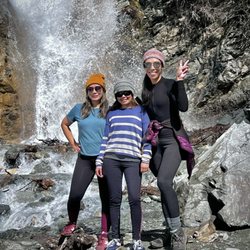
Talk about a real kick in the butt! The Devil's Backbone trail is definitely not for the feint of heart. This 12-mile loop involves hiking steep scree slopes, traversing across mountain ridges, dealing with strong crosswinds, and the likes. If you are an avid hiker, this hike is definitely a great workout and the views are magnificent from start to end! You can start the trail multiple ways. You can either start it from 1) the Visitors Center (Old Mt. Baldy Trail), 2) Manker Flats/San Antonio Falls (we did this one), 3) from the Sugar Pine Ski Hut parking lot (this trail intersects the Manker Flats trail closer to the Top of the Notch), or 4) from the Top of the Notch at the top of the ski lifts (shortest overall distance). Since we took the Manker Flats approach I suppose my review would gear more towards that. The Makner Flats/San Antonio Falls trailhead is located on the side of the road maybe a quarter mile from the Sugar Pine parking lot. When nearing the end of Mt. Baldy Rd., the two lanes of traffic will split and eventually, you will see a small left turn that allows you to cut across to the opposing side. From there you will see a wide opening and a white gate which is the start of the trail. The first section starts off paved up until San Antonio Falls which is roughly a half mile up. From there, it is another 3mi to the Notch where there is food, restrooms, etc. From the Notch, the peak is about another 3 miles away. The start of the trail from the Notch is northwest of the Notch alongside the 2nd ski lift. This is a 1 mile stretch of steep scree and eventually eases out when you reach the top of the ski lift. From here, it is another gradual 1.5mi ascent to the Baldy Bowl section. Here, you might be able to catch a glimpse of people climbing the last quarter mile up to the peak (you might stop at this point and question what you got yourself into). The final quarter of a mile to the peak is steep and rather confusing. There are trails that go every which direction, so as long as you can find a safe path up the peak, take it. At the top, you will be greeted with a 360 degree view of the vicinity, from the High Desert, to the IE, and even a decent amount of the San Gabriel Valley on a good day. At this point you can continue down the West Baldy trail to complete the loop, but our group decided to just go back the same way in which we came from. Total distance was just over 12mi. according to my GPS. Note: This hike is probably best done during the warmer months. If you plan to do this in late Fall or Winter, you may possibly need crampons and an ice axe as the trail may be covered in snow/slick ice. I would advise checking weather conditions to be sure that you won't hit any snow when going up and also be mindful of previous days' weather as the snow/ice may still remain from storms a few days (or even weeks) prior. Fortunately for us (or unfortunately, depending on how you look at it), California hasn't seen much wet weather this year, so even though we hiked it in the Winter, the trail was largely clear. There were only small spots of snow and ice throughout. read more


. - Hiking Near Me - Mount Baldy, California")
11 years ago
14 years ago


11 years ago
WARNING: THIS TRAIL CAN BE THE ABSOLUTE WORST IF YOU DON'T HAVE PROPER HIKING SHOES! A couple of friends and I started from the Manker Flats parking area at 7am, and it took about an hour and 15 minutes to get through the fire road and reach the ski cabin at the top right before the Backbone trail. The incline here is steady but I definitely felt the burn -- perhaps because I was an idiot and did leg day at the gym the day before. At the cabin where the ski lifts drop people off, there's a decent restroom area to do your business before embarking on the Backbone - take advantage of it! At this point, there are two trails to the left, both of which will lead to the same area. The farther left path (I've heard) is slightly longer but easier, and not as steep as the one to its right, which is the one we took. LOOSE GRAVEL EVERYWHERE! Shoes are integral here, otherwise you'll be wasting a lot of your energy just trying to get stable footing. Beware, it's VERY steep, but more direct. The Backbone itself wasn't too bad in my opinion. It wasn't until the very last stretch before the top where it gets mega steep again, but there's a little bit of flatland to get you warmed up and prepared. Lucky for us it wasn't sunny when we went, because it's not even slightly shaded. Once you reach the top it's like a whole new world! Every strenuous step and deep heaving breaths be on worth it when you take in the view from the highest point in Los Angeles county. We stayed up there for about 40 minutes eating our lunch and taking pictures, then descended back down in a loop. I've heard that coming back the way you came is shorter, but with the trifecta of strong gusts, unstable footing, and steepness, we didn't want to take a chance. All in all it took us four hours to get up and three to get down. Good luck fellow hikers! read more


7 years ago
14 years ago
10 years ago
This is definitely worth the hike but its not for the faint of heart. Its a serious 4.5 mile very steep hike. Take lots of water and good shoes. If you want to cut it in half and make it easier take the ski lifts up and start from there. read more

Page 1 of 2
More info about Devil's Backbone
6777 Mt Baldy Rd
Mt Baldy
Mount Baldy, CA 91759
Directions
Hours
Outdoor Amenities
Ask the Community - Devil's Backbone
Review Highlights - Devil's Backbone
You might also consider


Devil's Backbone - hiking - Updated June 2026
Best of Mount Baldy
People found Devil's Backbone by searching for…
Beaches in Mount Baldy, California
Hiking Trails With Waterfalls in Mount Baldy, California
Things to Do in Mount Baldy, California
Rock Climbing in Mount Baldy, California
Campgrounds in Mount Baldy, California
Visitor Centers in Mount Baldy, California
Scenic Drive in Mount Baldy, California
Waterfalls and Swimming Holes in Mount Baldy, California
Scenic Night View in Mount Baldy, California
Lookout Points in Mount Baldy, California
Parks in Mount Baldy, California
Dog Friendly Hiking Trails in Mount Baldy, California
Off Road Trails in Mount Baldy, California
Sightseeing in Mount Baldy, California
Sunrise View in Mount Baldy, California
Scenic Overlook in Mount Baldy, California
Skyline View in Mount Baldy, California
Night Hike in Mount Baldy, California
Waterfalls in Mount Baldy, California
Natural Hot Springs in Mount Baldy, California
Camping Sites in Mount Baldy, California
Camping Cabins in Mount Baldy, California
Browse Nearby
Browse Brands
Browse Articles
People who viewed Devil's Backbone also viewed
Cucamonga Peak
109 reviews
Stoddard Canyon Falls
33 reviews
Etiwanda Falls Trail
58 reviews
Bridge to Nowhere
5 reviews
Old Baldy
12 reviews
Lytle Creek Ranger Station
39 reviews
West Fork Trail
31 reviews
Marble Head Placer Claim No. 6
1 review
Lytle Creek - Cajon Pass Recreation Area
3 reviews
Sugarloaf Peak
1 review