Three T's Trail Photos


You might also consider
More like Three T's Trail
Recommended Reviews - Three T's Trail
Start your review...

Reviews With Photos

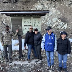
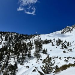
This hike, taking the Icehouse Canyon Trail, is about 14 miles with 6,100 total elevation gain. The 3 T's consist of a group of peaks which are located between Icehouse Saddle and the Baldy Notch, They include the 1st peak,Timber mountain (8303'), 2nd peak,Telegraph Peak (8985'), and 3rd peak, Thunder Mountain (8587') It is a fairly difficult hike overall, with the toughest climb from Timber to Telegraph Peak. Hiking to the 3rd peak,Thunder Mountain, is not nearly as challenging. Overall, it makes for a very long day of hiking, but it is a great leg workout and calorie burner. Most of the trail is single file with loose rocks under foot. The hike consists mostly of a steady incline, but there are steep portions. Parts of the trail are shaded but mostly unshaded. Go early in the morning to avoid the heat, especially in the summer. Views are interesting thoughout, but the most spectacular views are offered from Telegraph Peak. It was definitely worth the summit. parking - small lot located at the start of the trail. Adventure pass required

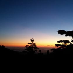
I did this great hike back in September of 2019 and really loved it despite it being one of the 5 hardest hikes I have personally done. Parking- an Adventure Pass is needed which costs $5 for one day or $30 for the year (I like to get the annual and add a 2nd car pass for $5 additional dollars and split the cost with a hiking buddy...so $17.50 and we each have a pass for our car for the year); my hiking buddy Jose parked his car at Manker Flat and I drove him back to the Ice House parking lot where we started our hike from Trail- the Ice House Canyon Trail is beautiful and you are hiking near the Ice House Creek for most of the 3.5 miles up to the saddle; this section is pretty busy since this is the trail that people who are hiking to Ontario Peak or Cucamonga Peak use also; once at the saddle most people take a little snack break since you have been steadily climbing for the past hour and a half; trails signs are visible at the saddle and the Three T's trail is to the left and the next 3.5 miles I found to be the hardest as you make your way to Timber and Telegraph Peaks...the views along the trail and at the peaks are phenomenal (esp. Telegraph)...this portion the elevation will be between 7,500 and 9,000 ft so depending on how comfortable you are at the altitude you may experience some fatigue/breathing issues; the final peak of the Three T's, Thunder Mountain, is the easiest to reach but it is the least impressive; from Thunder you make your way down to the Baldy Notch which has a bathroom, water refill station, and a good place to buy a snack or a drink; after taking a 15-20 min break at the lodge area we made the boring walk down the fire road to Manker Flat for about 3 miles...if you don't have a 2nd car parked here than you need to walk a couple more miles down the paved Mt. Baldy Rd back to your one car at Ice House or maybe someone will see you walking and offer you a ride down to your car Details Distance- almost 14 miles Elevation Gain- almost 5k feet Elevation Peak- 8,976 ft Duration- Total time of 7hrs with 5.5 hrs of actual hiking time since we took 5 breaks (saddle, each of the Three T's, and at the notch) *the first half (7 miles) of the hike is the hardest since you are averaging between 500-800 ft of elevation gain per mile Tips- start early since this hike will take most people between 6-8 hrs and you will want to avoid the effects of heat/sun exposure; bring layers since there will be temperature fluctuations; wear hiking shoes/boots...wouldn't recommend wearing just tennis shoes on this one; bring 2-3 liters of water, pack snacks, hiking poles might be good but not a must, and try to use 2 cars so you can park one at each lot (Manker & Ice House) read more


 - Hiking Near Me - Mount Baldy, California")


 - Hiking Near Me - Mount Baldy, California")


8 years ago
Like the great views, lodge for snacks, chair lift down. Lodge staff thoughtfully gave senior discount $10 tickets for chair lift down. Sorry to say potato wedges are nearly addictive- our group of 7 went through 3 baskets. Liked the cool breeze that made top areas pleasant while temperatures down in the village got into 90s in mid July. Thankfully, water for refilling containers was available at lodge at top of lower chair lift, say 10 miles in. TheHikingGuy has useful web page and video of the route. Could use portable signs, for photos, like one sees on Mt Gorgonio etc. read more


11 years ago
TELEGRAPH TIMBER, THERE'S THUNDER ON THE MOUNTAIN! BACKGROUND: Thunder Mountain: (Elevation 8587ft) Thunder is the northernmost of what Southern California peak baggers refer to as the "Three T's", the other two being Telegraph Peak (8,985) and Timber Mountain (8,303). Thunder Mountain is by far the easiest of the three, due to the existence of a road (closed to vehicle traffic) to the summit, and a trailhead 1,000' higher than the typical approach for the other two. Telegraph Peak (elevation 8985ft): Named for uncertain reasons. Telegraph is set on the border between the Angeles National Forest and the San Bernardino National Forest. Often overshadowed by its neighbor to the northwest, Mount Baldy (San Antonio), Telegraph Peak is much less visited, but no less magnificent. Timber Mountain: (elevation 8303ft.)Name given by early Sierra Club skiers and hikers (ca. 1930). It was singled out by Walt Wheelock as one of 30 early peaks. STATS: 10.5 miles shuttle route w/the ski lift Elevation gain: 2500 (overall) Elevation starts at 5600' at the trail head ESSENTIALS: At least 3 liters of water Know your limits Hiking boots that can withstand water, ice, and snow Layered Clothing Gloves High protein food/snacks Electrolytes Camera Hat (optional) Sunscreen Trek/ski poles OUR ROUTE: Me and The Crew started our day as the sun was rising in Ice House Canyon at the ski hut below the Top of the Notch, at 7800ft. Here we purchased our round trip ski lift ticket. Two-by-two we hopped on ski lift chairs and accompanied by a guitar, sang our way to the top. At the top of the notch, we prepared our gear for a long, strenuous for some, day of trekking. Our first stop was Thunder Mountain. From Top of the Notch, we followed a fire/service road till we hit a ski slop. hiking up the slop was by far the most strenuous portion of Thunder, but eventually all prevailed. As if we hadn't climbed enough, after peaking on Thunder, we head up to Telegraph. If you don't like switchbacks, this one is not for you. However, unlike Whitney's 99 switchbacks, Telegraph has far less, but they are short and steep. The upside to going up Telegraph is the shaded trail and scenic view. As you can imagine, based on the elevation gain/loss, Timber was less strenuous then Thunder and Telegraph. Nice way to ease back into the lower elevation of our final resting place, Top of the Notch. Some ate a hardy lunch and toasted to our feat with a tasty beverage, while others rested before taking the ski lift down and heading to The Baldy Village for some grub and brew. Yelper Matt P. wrote in his review, "Make no mistake, hiking this isn't for the faint of heart...". His statement is on point. This is a good practice hike before heading to San Gorgonio, San Jacinto, and Mt. Whitney. However, if those are not on your bucket list, Three T's is a very scenic hike with over 2500ft of elevation gain. DISCLAIMER: Hiking is not something that can be taken lightly. It can be life-threatening as you see and hear on the news, people die or get lost all time. Please, if you are going to hike, never go alone and prepare for the worst, hope for the best. Remember when going for a hike, no matter how short you think it may be, always be prepared. Carry at least two liters of water for every five miles (more if the weather is warm), protein bar, nuts, and electrolytes. Wear sturdy lug sole shoes and protective clothing. Some areas the weather can change quicker than a fireman can put on his gear. It is also very important, always always always let a family member or friend know where you are going and when you expect to be back. Lastly, have fun when you hike it up. Review 54 Yelp 100+ Challenge 2015 #hiking #sangabrielmountains #3Ts #peatbaggers read more


11 years ago
This hike, taking the Icehouse Canyon Trail, is about 14 miles with 6,100 total elevation gain. The 3 T's consist of a group of peaks which are located between Icehouse Saddle and the Baldy Notch, They include the 1st peak,Timber mountain (8303'), 2nd peak,Telegraph Peak (8985'), and 3rd peak, Thunder Mountain (8587') It is a fairly difficult hike overall, with the toughest climb from Timber to Telegraph Peak. Hiking to the 3rd peak,Thunder Mountain, is not nearly as challenging. Overall, it makes for a very long day of hiking, but it is a great leg workout and calorie burner. Most of the trail is single file with loose rocks under foot. The hike consists mostly of a steady incline, but there are steep portions. Parts of the trail are shaded but mostly unshaded. Go early in the morning to avoid the heat, especially in the summer. Views are interesting thoughout, but the most spectacular views are offered from Telegraph Peak. It was definitely worth the summit. parking - small lot located at the start of the trail. Adventure pass required read more


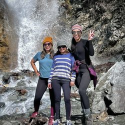
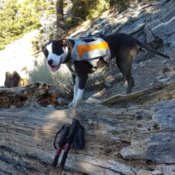
This has been my longest Mt. Baldy trail hike. The Three Tees Trail took me 16 miles, up 4,000 Feet of elevation gain and over Timber Mountain, Telegraph Peak and Thunder Mountain. And of course, to get there, I had to get up the Icehouse Canyon Trail. http://www.yelp.com/biz/ice-house-canyon-trail-mount-baldy#hrid:7xbAkpMLb89keNbcDHgMRA/src:self Since my hike was in August, and I hike with my pooch Sammy, we were at the Icehouse Canyon Trailhead by 4am... to avoid the heat on the climb up. This is a long hike, so even on our descent down in the heat I had to make sure I gave Sammy enough water and breaks so she wouldn't overheat. At 3.6 miles and 2,660 feet of elevation gain from the trailhead, we reached the Icehouse Saddle before sunrise, took a break then headed up the Three Tees trail as the sun was rising. The trail starts up an incline right away and passes by some Manzanita bushes and some unique fallen trees. On the main trail at 4.4 miles there is a 'Timber Mountain .25' sign. Head east up the hill 0.25 miles to reach your first T, Timber Mountain at 8,303 feet. Sign the register located inside the metal cylinder, mounted in the tree, just behind the top Timber Mt. sign. Wander around behind and to the left of that tree to see a large hollowed out and twisted fallen tree. From that tree I was tempted to just head north to reconnect with the 3 T Trail, but Sammy advised me otherwise. We have gotten lost (oops, I mean detoured) before and today was not a good day for that! So, we headed back down the same way we went up. When you reach the main 3 T Trail, continue north for 2 miles towards the second T, Telegraph Peak. At first the trail goes downhill for about a half of a mile, but then at 5.5 miles, it starts UP through some narrow leg scratching Manzanita bushes and some STEEP soft dirt switchbacks through the large trees. Off to the west are some amazing views! At one point, the dirt trail seems to end at the edge of the mountain and you find yourself having to scramble up and over the large rocky boulders. At 6.99 miles, you will come across a 'Three Tees Trail' sign. For some reason there is no Telegraph Peak trail sign here. But go to the right and head up the hill for 0.2 miles to reach the Telegraph Peak at 8,985 feet. Look for the aluminum register box and the Geological Survey Bench Marker embedded in the large rock. http://www.yelp.com/user_local_photos?select=pyCsV4-lTSAaVzBIRS3m9A&userid=RoGuDu1egfAvVgb4WmZwUw Look north and you will see the Mt Baldy Notch water reservoir and the ski lodge. After Sammy and I enjoyed the amazing view, we headed back down to the main 3 T Trail and headed north again to reach our third T, Thunder Mountain... all downhill for 1.2 miles. On the way at 7.0 miles, start looking 310 degrees North West to see the green roofed San Antonio Ski Hut. It will be small, so you have to look hard for it. On the slightest of fog days you will not see it. At 8.0 miles you reach a purple 'Three T's Trail - Cucamonga Wilderness' sign and the third T, Thunder Mountain at 8,587 feet. Look over the ridge and you will see the water reservoir and the ski lodge again. Here at Thunder Mountain you can continue towards the ski lodge for 1.5 miles to make this a looped hike, but then you have to hike down the road back to your car. I didn't want to hike a road, so I just turned around after Thunder Mt. and went back the same way I got there, making this a very long 16 mile hike! In my other hiking reviews I have written about what I take, this time I will cover how I prepare my pooch Sammy for these long mountain hikes. She is a black 70 pound LOVEABLE Pit Bull. First, I feed her a high protein dog food diet. She carries her own one liter water backpack, which I mix in some pet electrolytes for the hotter days. She usually drinks more than 1 liter, so I make sure to carry extra water for her. Some days we start our hike before sunrise to avoid the heat. On those days I put my red flashing bicycle light on her backpack so I won't lose her in the mountains. On the very cold days, I put her Hurtta Pro winter fleece and wind resistant jacket on and carry her Ultra Paws 'Rugged' boots and boot liners (which help putting her boots on easier) just in case the trails get too snowy or icy. Here she is in her gear getting ready for the Devil's Backbone. http://www.yelp.com/user_local_photos?select=O-Qs4DorsTDq847jcaY6Xw&userid=RoGuDu1egfAvVgb4WmZwUw I really like the cold winter gear I bought for Sammy at www.TheDogOutdoors.com. They even posted her pictures on their facebook. https://www.facebook.com/media/set/?set=a.704051822952592.1073741829.114967671861013&type=1 I love hiking with my pooch Sammy. And I try my best to make it enjoyable and safe for her! There is also a Yelp check in for Telegraph Peak. http://www.yelp.com/biz/telegragh-peak-mount-baldy?ob=1 read more


11 years ago
More info about Three T's Trail
Ice House Canyon Rd
Mount Baldy, CA 91759
Directions
Hours
Outdoor Amenities
Ask the Community - Three T's Trail
You might also consider


Three T's Trail - hiking - Updated June 2026
Best of Mount Baldy
People found Three T's Trail by searching for…
Parks in Mount Baldy, California
Things to Do in Mount Baldy, California
Scenic Drive in Mount Baldy, California
Hiking Trails in Mount Baldy, California
Running Trails in Mount Baldy, California
Scenic Overlook in Mount Baldy, California
Scenic Night View in Mount Baldy, California
Lookout Points in Mount Baldy, California
Off Road Trails in Mount Baldy, California
View Points in Mount Baldy, California
Sunrise View in Mount Baldy, California
Park & Forests in Mount Baldy, California
Beautiful Views in Mount Baldy, California
Sunrise Hike in Mount Baldy, California
Walking Trails in Mount Baldy, California
Playgrounds in Mount Baldy, California
Waterfalls and Swimming Holes in Mount Baldy, California
Photo Spots in Mount Baldy, California
Lakes & Ponds in Mount Baldy, California
Hiking Club in Mount Baldy, California
Redwood Forest in Mount Baldy, California
Full Moon Hike in Mount Baldy, California
Browse Nearby
BEST of Mount Baldy, California Restaurants near Three T's Trail
BEST of Mount Baldy, California Coffee near Three T's Trail
BEST of Mount Baldy, California Things to Do near Three T's Trail
BEST of Mount Baldy, California Breakfast near Three T's Trail
BEST of Mount Baldy, California Fishing near Three T's Trail
BEST of Mount Baldy, California Shopping near Three T's Trail
BEST of Mount Baldy, California Campgrounds near Three T's Trail
BEST of Mount Baldy, California Snow Tubing near Three T's Trail
Browse Brands
Browse Articles
People who viewed Three T's Trail also viewed
Box Springs Two Trees Trail
38 reviews
Santa Ana River Trail - Hidden Valley Wildlife Reserve Entrance
27 reviews
Cucamonga Peak
109 reviews
Old Mt. Baldy Trail
29 reviews
Devil's Backbone
63 reviews
Hidden Valley Wildlife Area
15 reviews
Challen Hill Park
12 reviews
Louis Rubidoux Nature Center
4 reviews
Idlehour Trail Camp
5 reviews
Blue Mountain Trail
21 reviews