Baldy Bowl Trail Photos


You might also consider
More like Baldy Bowl Trail
Recommended Reviews - Baldy Bowl Trail
Start your review...

6 years ago
Extremely hard for newbies!!! This is by far the most strenuous hike I've ever done!! It was hard to breathe and my heart was beating so fast that it felt as if it was about to jump out of my body. However, the scenic view was amazing and it's literally mind over matter when I wanted to turn back after the group started hiking to the top from resting at the green cabin place. When the group was nearly to the top, for every 15 steps we walked, we rested 5-10 mins. The trail was rocky and slippery, but it has a lot of shade (big bonus) making the hiking trip enjoyable beside it harsh elevation. All in all, this maybe my 1st and last time hiking this trail. Hehe. read more


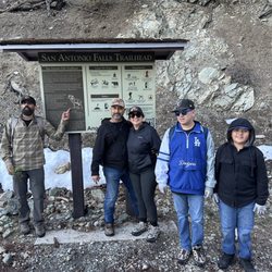
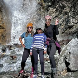
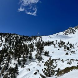
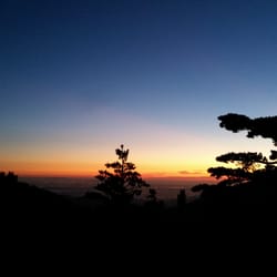
The hike up Baldy Bowl Trail, also known as the Ski Hut Trail to the summit of Mt. Baldy was one of the most difficult hikes I've done to date. The out and back round trip comes in at 9.2 miles, and you take on almost 4000' of elevation gain during the 4.6 mile ascent. Don't judge a hike by the distance; I've been on much longer hikes, yet never experienced such an ass kicking! Despite that, I totally love this trail and can't wait to take it again to the top! First, let me stress how easy it is to miss the trailhead from the fire road that starts at Manker Flats if you have never been here before. After you pass San Antonio Falls, it shouldn't take you more than 15 minutes to get to the trailhead. Keep your eyes peeled http://www.yelp.com/biz_photos/baldy-bowl-trail-mount-baldy?select=ZF95HefbyzFlmm02UyfS6w#ZF95HefbyzFlmm02UyfS6w for the lone yucca bush next to a trail splitting to the left and going up. Not too long ago there was apparently a sign that used to say "Mt. Baldy Trail" at the trailhead, but that sign is now missing. Hence my first time coming here, I ended up hiking past it going near the ski lifts and had to back track. I'll never forget that first time on the Baldy Bowl Trail. The visibility was bad and it was snowing as I hiked up. It isn't very often one gets to hike under snowfall http://www.yelp.com/biz_photos/baldy-bowl-trail-mount-baldy?select=JifbrRoARQwvBwa-w9vh8g#JifbrRoARQwvBwa-w9vh8g in LA so I stopped often to take it all in. That day, I never actually made it to the summit. I only made it to the Sierra Club San Antonio Ski Hut at the 2.5 mile mark. It was surreal approaching 8210' and out of the fog seeing this green building. Luckily, the door was open and I would end up spending the next couple hours in there by the furnace, chatting with some very cool people, drinking, eating, playing the guitar, and exploring the building. I had such a great time there that I didn't want to leave! But enough about the Ski Hut, that's another review http://www.yelp.com/biz/san-antonio-ski-hut-mount-baldy for another day! The next time I came back here, the conditions were totally different. It was an incredibly clear day and I could literally see out to the ocean and spot a few of the Channel Islands. The view out towards Catalina Island especially was so clear http://www.yelp.com/biz_photos/baldy-bowl-trail-mount-baldy?select=H3qwpO3LiBksGxHt1KGlEQ#H3qwpO3LiBksGxHt1KGlEQ that you could even count the ships between the coast and the island! I learned that the real ass kicking starts after the Ski Hut. I had to put traction device on my boots because the trail got pretty icy. After traversing past the big boulders, I started climbing up along the side of the Baldy Bowl as the big trees became more sparse and that's when things got really difficult! During the climb on the steep trail of loose rock and dirt through the manzanita bushes, I literally had to stop and take breaks every few minutes. At times, I would take these long breaks and get back up, start hiking again only to sit and rest after a minute or two because it was so tiring. I pushed myself up past the Baldy Bowl saddle http://www.yelp.com/biz_photos/baldy-bowl-trail-mount-baldy?select=CBS4x5_yn8Doz-HVzzQwsQ#CBS4x5_yn8Doz-HVzzQwsQ and with the toughest section behind me, I made my way towards the summit in the snow. I ran into a couple hikers just below the summit http://www.yelp.com/biz_photos/baldy-bowl-trail-mount-baldy?select=SvGhwRxBS5ifbDS-h0ZhuA#SvGhwRxBS5ifbDS-h0ZhuA also in awe of the breathtaking view. We talked about how lucky we were to make it up here on such a gorgeous day! You could really feel the wind as you summit at the top of Mt. Baldy. And you can see the snow swirling as the wind hits the ridge top, blowing the white powder into the air. It's an awesome sight! Even though it was really windy at the top, http://www.yelp.com/biz_photos/baldy-bowl-trail-mount-baldy?select=9XDwukBloHmiF_JYbaVhpQ#9XDwukBloHmiF_JYbaVhpQ nobody wanted to leave behind such a spectacular view. After taking a bunch of photos, collecting snow in my bottle (I had run out of water at that point), and even making a new friend at 10,064', I started my 4.6 mile descent down this awesome trail. I think I finally made it back to my car after spending over 8 hours on this hike! As strenuous as the hike is, you have to appreciate this kind of a challenge if you're a hiking enthusiast. We are lucky to have access to such a mountain without having to drive very far! Just remember to bring plenty of water (2 to 3L), food/snacks, hiking poles, and of course in the winter, some kind of traction device for your boots like microspikes or crampons. read more


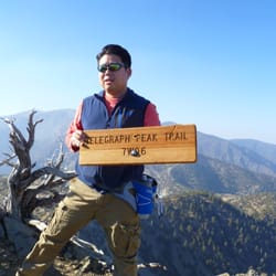
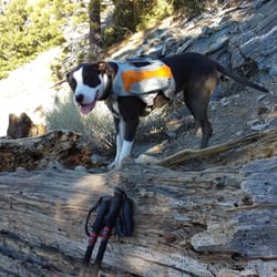
This is a great mountain trail loop that takes you up to Mount San Antonio, the highest peak on Mt Baldy at 10,064 feet. The preferred route, which happens to be the hardest way, is to take the San Antonio Falls Trailhead, up the Baldy Bowl Trail to the Peak and down the great Devil's Backbone Trail. The only downfall is walking the last 3.6 miles down from Baldy Notch on a wide dirt service road back to Manker Flats. Start by parking just after Manker Flats where the road splits in two, exactly 4 miles from the Mt Baldy Visitor Center. The San Antonio Falls trailhead is on the north side, off Falls Road, where there is a porti-pottie and a gate to go around. Walk up the asphalt road for 0.6 miles; just as you reach the sharp hairpin turn, the Falls is on the left. Continue to the right up the dirt road for another 0.3 miles to find the Baldy Bowl Trailhead on the left, also known as the Ski Hut Trail... but the actual sign is labeled 'Mt Baldy Trail'. (The road going straight is the way you will be coming down from the ski resort if you do the loop). http://www.yelp.com/user_local_photos?select=bUS9fLnblXfCFZ8Hm6m3Zw&userid=RoGuDu1egfAvVgb4WmZwUw Go left up the easy to miss STEEP trail for about 30 yards and sign the trail register. ** Make a note for another day, about 25 feet past the register box is a faint unmarked trail to the right. That is the Register Ridge Trail, which will take you up to the Devil's Backbone Trail one mile east of the San Antonio Peak. Once you are past the register box and the Register Ridge Trailhead, the Baldy Bowl Trail heads up the steep dirt trail along the edge of the ravine. Look up the mountain to the right and you will see the green roof of the Ski Hut. At 2.14 miles from the SA Falls Trailhead, the trail seems to end at a 3 foot boulder, a tree and the EDGE of the mountain. Pass through to the right, along the edge. Then at 2.22 miles there are a couple of huge boulders you will need to crawl over on all fours to get over. Don't go around and miss all the fun! Even my pooch Sammy goes over them. You gotta love these mountain trails! At 2.54 miles you reach the Ski Hut, putting you just a little over half way to the peak. There is a log bench and a table to take a short break at. Just behind the Hut there is a porti-pottie... just in case. Up until now the trail offers a lot of shade. But as you leave the Hut, you head into the sun to cross a small creek, pass over a rocky trail section and head up some STEEP switchbacks through the pine and fir trees before you get a little break at the first ridge above the Hut. Enjoy the great views here! After the ridge, the trail gets a little confusing as you reach the huge rocky boulders and Manzanita section. At 3.45 miles you should see a trail sign 'Baldy Bowl Trail To Manker Flat'. http://www.yelp.com/user_local_photos?select=2uoqnQWbWo5Ozwvy4OACmw&userid=RoGuDu1egfAvVgb4WmZwUw At the sign, look down the mountain about 50 yards for a USMC Hellcat plane that crashed in 1949. The wreckage is scattered all about. http://www.yelp.com/user_local_photos?select=i1IdzeVe9Ab4AHZOvnGfAQ&userid=RoGuDu1egfAvVgb4WmZwUw There is somewhat of a trail that goes down through the Manzanita bushes to the plane sections and loops back up towards the peak, to the main trail. Here you will be only 0.34 miles from the Peak. At 4.6 miles you reach the Peak at 10,064 feet! To complete the loop, head east and take the awesome Devil's Backbone Trail for 3.2 miles down to Baldy Notch at the ski resort. From there you will follow the boring dirt road for 3.6 miles, back down to San Antonio Falls and Manker Flats where you parked. This loop will cover around 11 miles and 3,904 feet of elevation gain. On my hikes I use the Runkeeper app on my phone. It's a great app that works off the satellite and does not require phone reception. It will run your phone battery down so I also carry an 'Anker Astro 5600mAh Backup External Battery Pack Charger' for all cell phones ($30). I also carry a Garmin Oregon 450t navigation device and a '3.0 Liter Platypus Insulator Hydration System'. I put ice cubes in it and the water stays cold all day. I like their top opening access better than Camelbak. Since the mountain weather can be unpredictable, I always carry a windbreaker and gloves. I just love the experience and the challenges of a mountain! read more


11 years ago
More info about Baldy Bowl Trail
Mount Baldy Rd & Falls Rd
Mount Baldy, CA 91759
Directions
Hours
Outdoor Amenities
You might also consider


Baldy Bowl Trail - hiking - Updated May 2026
Best of Mount Baldy
People found Baldy Bowl Trail by searching for…
Scenic Drive in Mount Baldy, CA
Waterfall Hike in Mount Baldy, CA
Sunset View in Mount Baldy, CA
Scenic Night View in Mount Baldy, CA
Scenic Overlook in Mount Baldy, CA
Off Road Trails in Mount Baldy, CA
Hiking With Kids in Mount Baldy, CA
Visitor Centers in Mount Baldy, CA
Hiking Trails Kid Friendly in Mount Baldy, CA
Lookout Points in Mount Baldy, CA
Tourist Attractions in Mount Baldy, CA
Dog Hiking Trails in Mount Baldy, CA
Scenic Spots in Mount Baldy, CA
Running Trails in Mount Baldy, CA
Beautiful Views in Mount Baldy, CA
Free Things to Do in Mount Baldy, CA
Hiking Groups in Mount Baldy, CA
Scenic Places to Walk in Mount Baldy, CA
Browse Nearby
BEST of Mount Baldy, California Restaurants near Baldy Bowl Trail
BEST of Mount Baldy, California Coffee near Baldy Bowl Trail
BEST of Mount Baldy, California Things to Do near Baldy Bowl Trail
BEST of Mount Baldy, California Breakfast near Baldy Bowl Trail
BEST of Mount Baldy, California Fishing near Baldy Bowl Trail
BEST of Mount Baldy, California Shopping near Baldy Bowl Trail
BEST of Mount Baldy, California Campgrounds near Baldy Bowl Trail
BEST of Mount Baldy, California Snow Tubing near Baldy Bowl Trail