Eagle Scout Trail Photos


You might also consider
More like Eagle Scout Trail
Recommended Reviews - Eagle Scout Trail
Start your review...

Reviews With Photos

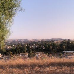
I love this trail, minus the very steep part at the start. Once your heart is beating out of your chest, the trail begins tapering off and makes it's way to a beautifully scenic ridge overlooking Pomona, Diamond Bar, Cal Poly, even Mt. SAC. I have seen as far as Catalina Island on the highest peak of the ridge. Sadly, new "No Parking" signs have been placed at the street side of Mission at the main trailhead.

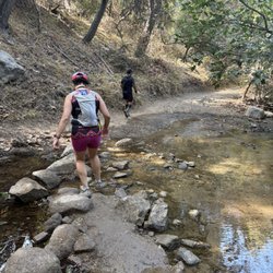
Came in through the other side, not on mission, it was just a random unlabeled entrance. Little hill on start and will continue with some rolling slightly rocky hills. Little bit of flat parts here and there with hard hills but nothing horrible! Good for a run depending which way you come up and will probably get a mile or two in if you do it all. Great view of all surrounding areas at the bench would definitely recommend.


7 years ago
My jam. I live across the street so this is a super convenient trail to do before work. It's about 3-4 miles and the incline is decent so you get a good workout. It's not busy like the Claremont Loop. They just put up no parking signs so I'm not sure where visitors are supposed to park. It was beautiful this spring due to all the rain. It's back to its desert looking self so don't come here for the scenery. Its cool at the top cause you can see all of the Six peaks but otherwise, lots of brown. There is no shade so I tend to go early morning or in the evening. There are also no bathrooms on the trail, so stop by the gas stations on Temple or Starbucks if you need it. There are a couple ways to go up. The one to the left is a bit steeper and has a rockier path involved. The other is the very obvious dirt trail to the right. The right trail is not as steep to start off with but also doesn't seem as "never-ending story" as the trail on the left. This is probably due to the fact that you can see where the trail is going. On the left trail, there's like 5-6 mini hills and you can't tell which one you're on until the top. The trail on the left will take you directly to the stone bench (only one on the trail). The trail on the right will take you to the fork in the trail that either leads you to the stone bench (left fork) or towards Diamond Bar (right fork). Check out AllTrails.com for a trail map. Most of the reviews are describing the left trail. read more


7 years ago
Not one of the best trails out there.. There's no map or post showing the trail route so you kinda just follow the exact gps location which led us to a side of the road where the trail starts lol We went to the right side of the trail and it definitely had some incline parts but the entire trail was waaay too rocky & dry. you can easily twist an ankle which is why I don't recommend it. We parked in the visitors parking across the street at the apartment complex and just waited until the road was clear to cross the street! All in all, It was OK but not the safest read more


7 years ago
I love this trail, minus the very steep part at the start. Once your heart is beating out of your chest, the trail begins tapering off and makes it's way to a beautifully scenic ridge overlooking Pomona, Diamond Bar, Cal Poly, even Mt. SAC. I have seen as far as Catalina Island on the highest peak of the ridge. Sadly, new "No Parking" signs have been placed at the street side of Mission at the main trailhead. read more


5 years ago
Came in through the other side, not on mission, it was just a random unlabeled entrance. Little hill on start and will continue with some rolling slightly rocky hills. Little bit of flat parts here and there with hard hills but nothing horrible! Good for a run depending which way you come up and will probably get a mile or two in if you do it all. Great view of all surrounding areas at the bench would definitely recommend. read more


14 years ago
One of if not the highest peak in the San Gabriel Valley! I park at the visitors lot at the apartment complex because you cant park on the other side. The view from here will give "Garcia Trail" a run for its money! read more

8 years ago
9 years ago
This is a good hike for everyone from kids to adults. It's challenging at certain points but over all a good workout! One of my favorites. read more

13 years ago
12 years ago
12 years ago
More info about Eagle Scout Trail
400 Appian Way
Pomona, CA 91766
Directions
Hours
Outdoor Amenities
Ask the Community - Eagle Scout Trail
Where exactly is the parking and entrance?
Hi guys, where is the entrance and where can I park? I was near an apartment complex (don't know the name of it) but I didn't see an entrance anywhere?
It's on the SW corner of Pipeline and Grand between Del Taco and Panda Express. The entrance is facing Pipeline.
I have never been but I really want to try it. Is it easy to get lost?
If you follow and stay on the trail you shouldn't get lost. Very easy trail!
Review Highlights - Eagle Scout Trail
You might also consider


Eagle Scout Trail - hiking - Updated July 2026
Best of Pomona
People found Eagle Scout Trail by searching for…
Trending Searches in Pomona, CA
Black Owned Nail Salons near Eagle Scout Trail
Boat Rental near Eagle Scout Trail
Cliff Jumping near Eagle Scout Trail
Day Trips near Eagle Scout Trail
Jet Ski Rental near Eagle Scout Trail
Kayak Rental near Eagle Scout Trail
Lakes & Ponds near Eagle Scout Trail
Off Road Trails near Eagle Scout Trail
Outdoor Activities near Eagle Scout Trail
Picnic Spots near Eagle Scout Trail
Places To Swim near Eagle Scout Trail
Places To Walk Around near Eagle Scout Trail
Pool Day Pass near Eagle Scout Trail
Public Pools near Eagle Scout Trail
Public Shower near Eagle Scout Trail
River Swimming near Eagle Scout Trail
River Tubing near Eagle Scout Trail
Rock Quarry near Eagle Scout Trail
Running Trails near Eagle Scout Trail
Scenic Night View near Eagle Scout Trail
Scenic Overlook near Eagle Scout Trail
Soccer Store near Eagle Scout Trail
Splash Pad near Eagle Scout Trail
Sunrise View near Eagle Scout Trail
Swimming Holes near Eagle Scout Trail
Swimming Lakes near Eagle Scout Trail
Watch Sunset near Eagle Scout Trail
Browse Articles
Browse Nearby
BEST of Pomona, California Coffee near Eagle Scout Trail
BEST of Pomona, California Things to Do near Eagle Scout Trail
BEST of Pomona, California Restaurants near Eagle Scout Trail
BEST of Pomona, California Breakfast near Eagle Scout Trail
BEST of Pomona, California Parks near Eagle Scout Trail
BEST of Pomona, California Walking Trails near Eagle Scout Trail
BEST of Pomona, California Hot Springs near Eagle Scout Trail
BEST of Pomona, California Campgrounds near Eagle Scout Trail
BEST of Pomona, California Snow Tubing near Eagle Scout Trail
Browse Brands
Related Searches in Pomona, CA
Best Fishing Locations and Guides in Pomona, California
Best Nature Trails for Hiking in Pomona, California
Best Places for Horseback Riding in Pomona, California
Check Out Off Road Trails in Pomona, California
Discover Dog Friendly Trails to Explore in Pomona, California
Discover Kid Friendly Hiking Trails in Pomona, California
Discover Scenic Hiking Trails in Pomona, California
Discover Scenic Mountain Bike Trails Near Pomona, California
Discover Scenic Waterfall Spots in Pomona, California
Discover Walking Parks in Pomona, California Near You
Discover a Hiking Trail in Pomona, California
Discover the Best Night Hike Trails in Pomona, California
Discover the Best Running Track in Pomona, California
Dog-Friendly Hikes With Dogs in Pomona, California
Enjoy Camping Adventures Around Pomona, California
Enjoy Exciting Mountain Biking Adventures in Pomona, California
Enjoy Kayaking Adventures in Pomona, California
Enjoy Tent Camping Spots Around Pomona, California
Enjoy a Beautiful Waterfall Hike in Pomona, California
Enjoy a Peaceful Nature Walk in Pomona, California
Enjoy the Best Walking Path in Pomona, California
Enjoy the Best Walking Trails in Pomona, California
Exciting Cliff Jumping Spots in Pomona, California
Explore Beautiful Parks and Green Spaces in Pomona, California
Explore Easy Hikes Perfect for All in Pomona, California
Explore Fun Activities to Do in Pomona, California
Explore Popular Campgrounds Near Pomona, California
Explore the Best Beach Spots in Pomona, California
Explore the Best Swimming Holes Around Pomona, California
Explore the Best Trail Options in Pomona, California
Family Friendly Hiking With Kids in Pomona, California
Find Beautiful Views in Pomona, California
Find the Best Parks for Picnics in Pomona, California
Find the Best Scenic View Locations in Pomona, California
Great Places to Walk in Pomona, California
Hike the Popular Waterfall Trail in Pomona, California
Hiking Trails With Waterfalls in Pomona, California
Off Leash Dog Hiking Trails in Pomona, California
Plan a Scenic Drive Route Near Pomona, California
Popular Outdoor Activities to Try in Pomona, California
Popular Picnic Spots to Visit in Pomona, California
Safe River Swimming Areas in Pomona, California
Safe and Fun Parks for Kids in Pomona, California
Top Climbing Spots and Gyms in Pomona, California
Top Paddleboarding Activities in Pomona, California
Top Running Trails to Explore in Pomona, California
Top Swimming Lakes to Enjoy in Pomona, California
Top Swimming Spots and Pools in Pomona, California
People who viewed Eagle Scout Trail also viewed
Steep Canyon Trailhead
149 reviews
La Sierra Trail Loop
73 reviews
Michael D. Antonovich Trail
99 reviews
Marshall Canyon Regional Park
40 reviews
Eucalyptus Trail Loop
64 reviews
Summitridge Park
63 reviews
Walnut Creek Park
70 reviews
Ice House Canyon Trail
129 reviews
Helen McCoy Loop
2 reviews
Baldy Bowl Trail
4 reviews