Potato Mountain Photos

 - Hiking Near Me - Claremont, California")


You might also consider
More like Potato Mountain
Recommended Reviews - Potato Mountain
Start your review...

Reviews With Photos - Potato Mountain

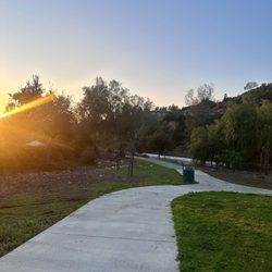
Super fun hike with great views, especially from the top! I found this to be an extremely pleasant hike - it's a mostly gradual incline, lots of shade, wide trail, polite hikers - very decent. The ground is rocky and uneven a lot of the way but it's definitely very manageable. We went 5.4 miles and gained 1224 feet and we spent about 3 1/2 hours doing it very leisurely - I take a lot of photos and we spent a lot of time at the top having fun so it adds time on. AllTrails calls this hike moderate and I think that's accurate. There are spots where the incline can be intense, but for the most part it's gradual. I'd say this trail is probably about 60-70% shade as well. And along the first mile or so, you can hear a nice flowing stream down in the ravine! At the top there's a raised, circular cement area where everyone places their potato offerings lol! We brought a potato and decorated it to mark the occasion lol! Super fun! There used to be a cool sign at the top that you could take a picture with, but sadly it was gone - apparently it was there last week so not sure what happened. The trail is very heavily trafficked. Tons of hikers, a few mountain bikers, and even a crazy unicycler skirting the rim of the trail!! We got there at around 730am on Sunday and it was already packed. By the time we got back to the car around 11am, parking was already 3 rows deep and becoming hard to find (see my pics). There's plenty of room for social distancing and most of the hikers aren't wearing masks which is not an issue for me but if you're at all scared of this kind of scenario, don't do this hike. For the most part, the hikers and bikers (and unicycler lol!) are polite and respectful. There's a little graffiti along the trail sadly. And we really only had one weird encounter - a woman pulled her pants down and peed on the trail - yes, the actual trail right in front of us - no modesty, no cover, just naked and peeing on the trail and left her toilet paper right there too. I was shocked and appalled to say the least lol. But this is LA and a very packed trail so just be aware you might get some weird stuff going on. The trailhead has signs saying "no public access" and "no trail access". I knew that before coming and tried to research but still don't know why, bc everyone enters here. I'm guessing maybe they just don't want anyone parking there. At the entrance, there's a yellow gate across the trail, but there's a hiker entrance opening just to the left, like so many other trails out here so it must be allowed. Not to mention that there are TONS of hikers entering. Parking is in a gravel lot about 1/4 mile away. After you park, you have to walk along the road and it's a little scary bc there's a lot of fast traveling cars and such - so just be careful. Also, there are no bathrooms.


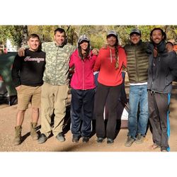
After our hike today, I can say this is going to be one of our favorite hikes. There are lots of parking along the road and we walked to the entrance. The trail is clear and easy to follow. These yellow flowers along the trails smells so sweet. Steady incline, not so rocky, weather today was perfect. We took our time and stopped couple of times to rest. It was 4.6 miles round trip, 1400 ft elevation, took us about 3-1/2 hrs because we took a lot of stops. There were lots of people on the top just enjoying the view and having snacks. We took couple of pictures and then head back down. This is easy to moderate hike.

I visited Potato Mtn on Jan 2021 and wanted to share my tips from the hike! PROS 1) moderate hike and a majority of the hike is shaded by trees. Less shade obviously as you get higher to the top. 2) the hiking trail is fairly wide, which is great during covid times. 3) Bring your own potato to leave at the shrine if you wish! 4) roundtrip is ~5.5 miles and took about 2 to 2.5 hrs. Elevation gain is ~1300ft. CONS 1) This is just a warning, but if you google map "potato mtn trailhead", it will take you to an unmarked trail head entrance with a no public access sign (refer to photo). Despite the signage, many people still use the trail. I can confirm that the trail does lead to the potato mtn summit. About 0.2miles before the entrance on google map, one will bypass a giant dirt parking area, which is where one will park. Be careful walking to the entrance as there is NO pedestrian walkway or bike path. If you've walked to the "welcome to Angeles National Park sign, you've walked too far. The trail head entrance should have a yellow gate. As a visitor to the area, this weird entrance threw me off, but I sorta followed the crowd lol. Enjoy the hike and the views!
")

No sign where the trailhead starts was a pain. It took me like 30 mins to go round and round to find it. I eventually found it on YouTube. The trail itself was fun. It was steep, but not that steep. Well, up until the very end it got pretty steep for a beginner/mid hiker level. There was a little stream (maybe a river) which was calming. Overall, it's a pretty good trail with a good view in the end.

Nice views from the top! About 5 mile round trip starting from the parking lot. This took about 2 hours with some rest at the top. Parking isn't allowed at the trailhead so you need to park about 1/4 miles down at a big dirt parking lot. The parking lot will be on the right side if you're coming up from Claremont. Continue to walk up the mountain road on the right side until you see an trail opening across the street. Cross the street and walk past a yellow barrier. The last one mile to the top was somewhat intense due to the inclines! Good workout though.

This was tricky to find but easily became one of my favorites! It's a pretty easy hike; there's a gradual incline at the beginning while your body is still warming up so it feels a little hard, and incline at the end but your body is warmed up by then and it feels like nothing. Between that it's just good views and a fun hike! I highly recommend !

Since hiking was the best non-covid activity of 2020, we started 2021 with a hike as well! Potato Mountain was an easy to mild difficulty and worked out great on a chilly January morning. It is on the way to Mt Baldy, so gets a bit more crowded on weekends. The trail is about 6 miles long, and it took us an hour to get up (no stops) and about 30 min to get down, with 30 minutes to spare and enjoy the views on the top. Most of the hike is a pleasant walk up in the shade of the mountain (at least at 8 am), and the last mile is a bit more strenuous with a steeper incline. As usual, you get a beautiful view of the SGV, but I did not care much for the "potato platform" with all the signs and graffiti... There is a small parking lot on the west sound of the road, and you will need to walk 5-6 min, cross the road, and start the hike at the schlagbaum.

We picked a perfect day to hike here. The views and vistas were out of this world! This trail rates as a moderate hike and, in my opinion, it's exactly that. A steady climb takes you up the mountain until you reach a sign that points you to Potato Mountain. From there, it's tough. The ascension is steeper but once at top, it makes it all worth it! Would definitely recommend!

It was AMAZING!!! totally kids friendly hike . It was 4 of us my kids ages range from 11 yrs old ...9yrs old and my 6yrs old we all made it to the top of potatoe mt. It was worth it and definitely coming back again !! The view is AMAZING! i read ppl can take up to 2 hrs going up to 3 1/2 hrs we made it in 1 hrs with 30 mins with lots of breaks . Pack water and snacks.

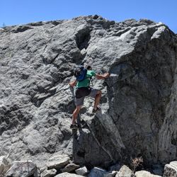
Let me start by saying this is not as easy as some of these reviews make it sound. Whoa is it a tough steady uphill climb! The whole way up I kept asking myself what in the duck did I get myself into, and asking myself why people like to torture their bodies with uphill hiking! Well the answers to those questions is arriving at the peak of potato mountain, knowing that you conquered that hike to the top all on your own! The views are amazing, and taking a look at all the potatoes is pretty fun! Everyone is incredibly friendly along the trail. Lots of older folks walking along the trail. The sound of the creek running along the north side of the trail sounds so refreshing and offers a few perfect picture taking moments, and one spot even had a great little area you could rest your weary legs. It's very rocky along the trail and to be honest I don't know how people do it with just a pair of tennis shoes. I had hiking boots on and my feet are sore from all the rocks. I almost tripped on one rock on the way down too. So be careful! There was plenty of shade on the way up and a few very sunny spots. It's a bit windy at the top so although no shade, if felt so amazing up there. Will definitely attempt this again. It's hard but I survived and I feel better for getting up and getting out there, while trying something new! Adventure Awaits!

I recently went on this hike with my hubs after having it bookmarked for years. We parked at the North lot of the Claremont Hills Wilderness Park on Mills Ave because I knew our car would be safe there from vandalism- the Claremont park rangers are frequently patrolling the lots. I do NOT recommend parking on Mt. Baldy Rd- first, it is a no parking zone so you can get cited for a $50 ticket, second, tons of traffic accidents happen between pedestrians and vehicles all the time, and lastly, your car has a a very high likelihood of getting broken into. I highly recommend paying the $5 on weekdays or $7 on weekends and park in a safer lot for your own peace of mind. Once you enter the loop, it will add 5 miles to your hike- bringing the total to around 9 miles. As you walk-in you'll come to a fork that splits to the left and right, labeled Burbank Canyon Mtn Way (left) and Cobal Canyon (right)- take Cobal Canyon. You can take Burbank, but it'll add more miles and time to your hike. You'll hike through a shaded area for around 0.50 miles, and after that, it'll be full sun, no shade for almost the rest of the way. Once your up about 1.5 miles, you'll see a yellow gate with a sign stating you're leaving the CHWP and entering Evey Canyon. It'll list Potato Mtn. You'll go through that gate. Then it's a steady incline and there are clear signs along the way to help you navigate. It is a rocky hike, and once you leave the loop, we had the trail pretty much to ourselves on a weekday. Once at the top, I was sad to see graffiti- next time I'm bringing spray paint to paint over it. The views made up for it though. I was able to see all the way to downtown LA and beyond. If it wasn't for the smog, I bet I could see all the way to Catalina Island. We didn't bring a potato. I wish I had brought a small picnic- like sandwiches to eat once you're up at the top. Of course, practice good hike etiquette- pack your trash out, never leave any garbage behind. The trail was pretty clean so I think many are following the etiquette. Note: Wear a hat, whatever sun protection you want, sunblock, and bring plenty of water. Once you pass the gates at the loop, there is no water source. If you bring your dogs, bring lots of water for them as well. The park rangers have mentioned dogs have died in their Wilderness park due to careless owners not bringing enough water for their dogs- don't be that person- it'll be devastating for you and a sad way to go for your fur babies. Don't forget- it is way hotter for your dogs to be lower to the ground, combined with fur, and no way to sweat. Truthfully, I don't recommend this hike for dogs. Please keep that in mind. I didn't bring my dogs because 9 miles is way too many miles for my Shibas in full sun, along with knowing there'll be rattlesnakes, tarantulas, bears, coyotes and mountain lions. If they were to get a snake bite, it wouldn't look good. The park rangers patrol just the Claremont portion. Potato Mtn is in the Angeles forest and a different jurisdiction- and the trail is not able to accommodate vehicles easily as some parts are too narrow- most like you'd have to be airlifted out. Wear shoes with traction, as the trail is kind of rocky. I brought hiking sticks to help with the downhill. Weekends will def be busier. There is poison oak so try to keep your hands off any three leaf plants. If you mountain bike, this trail isn't for the novice biker. You'll reach some serious downhill speed. I saw one mountain biker and the hill was so rocky and steep at one point he was walking his bike up. I would hike it first to see if you think you can bike it. Since it is shared with hikers, they'd be in the way. I like mountain biking in designated mtn biking trails like in Moab, Utah. Anyway, enough of my tips on safety. I heard what happens on these hikes so I want to make sure everyone stays safe and enjoy it the fullest. This is a fun trail that's marked well and is a relatively easier hike because of the steady incline. Still kicked my butt. I would say it is an intermediate level hike, def not a beginner hike. If you are out of shape, this hike will be hard. Don't listen to the reviews saying this hike is easy. Combine the hike with the usual SoCal heat and it'll be challenging. It is not a beginner's hike, the downhill is steep and will be hard for anyone with knee issues. Going up will burn the heck out of your booty. It is a good workout hike, but not for those who don't really workout.

My friend and I went hiking in Claremont and intended on doing the loop, but when we saw the sign leading to Potato Mountain, we decided to head up! I've only heard about this spot, but have never been so I was excited to explore. The hike is not shaded and has a steady incline, so I was grateful that it was overcast and cool most of the day. The trail is wide enough for a car to drive on, and no major rocky areas, so I would say that if you were reeeeeally ambitious and wanted to push a jogging stroller up and down, you probably could. There are occasional bikers that we passed, but otherwise just a few hikers doing this trail, much less than the number of people doing the loop, which I actually liked. With the exception of the ugly graffiti on the concrete thing at the top, we were rewarded with a beautiful view of the valley on one end, and snow capped mountains on the other end. It didn't take that long to summit ( I think it took us less than an hour each way), so if you have a couple hours for something a little more challenging than the loop, this is a good hike! Parking is available in the lot starting at $10 (Yikes!) on the weekends. Enjoy! read more

First time visitor There are not bathrooms anywhere There are a few (3?) trash can / compost / recycle green bins at the start of the trail There is not a designated parking area if coming on MT Baldy RD, park after the last No Stopping Any time sign (will see Angeles Forest large sign) then can park on the side of the road and forward Be aware of oncoming traffic both directions when walking to the trail head Bring a hat, sunglasses, sunblock, water, snacks It is dog friendly but tough for stroller I think based on continual incline and gravel and rocky terrain Also note air may feel thinner as you start the trail so be mindful of your breathing and take rest stops Start of trail will be walking through shaded area with tree and can hear water and as continue the pathway make your descent up As you make your way further up, there will be part to turn left or go straight to the right, head to the left to continue upward - you'll see amazing clouds surrounding the mountain and the trail continuing You'll see a pathway that curves down the hill then back up, a right triangular metal sign will indicate going the right way and almost to the end of the trail. Other markers is seeing small forms of graffiti and the name Joey tagged on things Once on top, enjoy your accomplishment and then it's primarily a down hill return Enjoy Hydrate Limited cell service pending what part of the mountain on Enjoy the birds flowers rock formation little critters that pop In and out Would certainly return to try the other routes to potato mountain read more


3 years ago
Super fun hike with great views, especially from the top! I found this to be an extremely pleasant hike - it's a mostly gradual incline, lots of shade, wide trail, polite hikers - very decent. The ground is rocky and uneven a lot of the way but it's definitely very manageable. We went 5.4 miles and gained 1224 feet and we spent about 3 1/2 hours doing it very leisurely - I take a lot of photos and we spent a lot of time at the top having fun so it adds time on. AllTrails calls this hike moderate and I think that's accurate. There are spots where the incline can be intense, but for the most part it's gradual. I'd say this trail is probably about 60-70% shade as well. And along the first mile or so, you can hear a nice flowing stream down in the ravine! At the top there's a raised, circular cement area where everyone places their potato offerings lol! We brought a potato and decorated it to mark the occasion lol! Super fun! There used to be a cool sign at the top that you could take a picture with, but sadly it was gone - apparently it was there last week so not sure what happened. The trail is very heavily trafficked. Tons of hikers, a few mountain bikers, and even a crazy unicycler skirting the rim of the trail!! We got there at around 730am on Sunday and it was already packed. By the time we got back to the car around 11am, parking was already 3 rows deep and becoming hard to find (see my pics). There's plenty of room for social distancing and most of the hikers aren't wearing masks which is not an issue for me but if you're at all scared of this kind of scenario, don't do this hike. For the most part, the hikers and bikers (and unicycler lol!) are polite and respectful. There's a little graffiti along the trail sadly. And we really only had one weird encounter - a woman pulled her pants down and peed on the trail - yes, the actual trail right in front of us - no modesty, no cover, just naked and peeing on the trail and left her toilet paper right there too. I was shocked and appalled to say the least lol. But this is LA and a very packed trail so just be aware you might get some weird stuff going on. The trailhead has signs saying "no public access" and "no trail access". I knew that before coming and tried to research but still don't know why, bc everyone enters here. I'm guessing maybe they just don't want anyone parking there. At the entrance, there's a yellow gate across the trail, but there's a hiker entrance opening just to the left, like so many other trails out here so it must be allowed. Not to mention that there are TONS of hikers entering. Parking is in a gravel lot about 1/4 mile away. After you park, you have to walk along the road and it's a little scary bc there's a lot of fast traveling cars and such - so just be careful. Also, there are no bathrooms. read more


After our hike today, I can say this is going to be one of our favorite hikes. There are lots of parking along the road and we walked to the entrance. The trail is clear and easy to follow. These yellow flowers along the trails smells so sweet. Steady incline, not so rocky, weather today was perfect. We took our time and stopped couple of times to rest. It was 4.6 miles round trip, 1400 ft elevation, took us about 3-1/2 hrs because we took a lot of stops. There were lots of people on the top just enjoying the view and having snacks. We took couple of pictures and then head back down. This is easy to moderate hike. read more


6 years ago
I visited Potato Mtn on Jan 2021 and wanted to share my tips from the hike! PROS 1) moderate hike and a majority of the hike is shaded by trees. Less shade obviously as you get higher to the top. 2) the hiking trail is fairly wide, which is great during covid times. 3) Bring your own potato to leave at the shrine if you wish! 4) roundtrip is ~5.5 miles and took about 2 to 2.5 hrs. Elevation gain is ~1300ft. CONS 1) This is just a warning, but if you google map "potato mtn trailhead", it will take you to an unmarked trail head entrance with a no public access sign (refer to photo). Despite the signage, many people still use the trail. I can confirm that the trail does lead to the potato mtn summit. About 0.2miles before the entrance on google map, one will bypass a giant dirt parking area, which is where one will park. Be careful walking to the entrance as there is NO pedestrian walkway or bike path. If you've walked to the "welcome to Angeles National Park sign, you've walked too far. The trail head entrance should have a yellow gate. As a visitor to the area, this weird entrance threw me off, but I sorta followed the crowd lol. Enjoy the hike and the views! read more


 - Hiking Near Me - Claremont, California")


3 years ago
No sign where the trailhead starts was a pain. It took me like 30 mins to go round and round to find it. I eventually found it on YouTube. The trail itself was fun. It was steep, but not that steep. Well, up until the very end it got pretty steep for a beginner/mid hiker level. There was a little stream (maybe a river) which was calming. Overall, it's a pretty good trail with a good view in the end. read more


Nice views from the top! About 5 mile round trip starting from the parking lot. This took about 2 hours with some rest at the top. Parking isn't allowed at the trailhead so you need to park about 1/4 miles down at a big dirt parking lot. The parking lot will be on the right side if you're coming up from Claremont. Continue to walk up the mountain road on the right side until you see an trail opening across the street. Cross the street and walk past a yellow barrier. The last one mile to the top was somewhat intense due to the inclines! Good workout though. read more


3 years ago
This was tricky to find but easily became one of my favorites! It's a pretty easy hike; there's a gradual incline at the beginning while your body is still warming up so it feels a little hard, and incline at the end but your body is warmed up by then and it feels like nothing. Between that it's just good views and a fun hike! I highly recommend ! read more


5 years ago
Since hiking was the best non-covid activity of 2020, we started 2021 with a hike as well! Potato Mountain was an easy to mild difficulty and worked out great on a chilly January morning. It is on the way to Mt Baldy, so gets a bit more crowded on weekends. The trail is about 6 miles long, and it took us an hour to get up (no stops) and about 30 min to get down, with 30 minutes to spare and enjoy the views on the top. Most of the hike is a pleasant walk up in the shade of the mountain (at least at 8 am), and the last mile is a bit more strenuous with a steeper incline. As usual, you get a beautiful view of the SGV, but I did not care much for the "potato platform" with all the signs and graffiti... There is a small parking lot on the west sound of the road, and you will need to walk 5-6 min, cross the road, and start the hike at the schlagbaum. read more


We picked a perfect day to hike here. The views and vistas were out of this world! This trail rates as a moderate hike and, in my opinion, it's exactly that. A steady climb takes you up the mountain until you reach a sign that points you to Potato Mountain. From there, it's tough. The ascension is steeper but once at top, it makes it all worth it! Would definitely recommend! read more


2 years ago
It was AMAZING!!! totally kids friendly hike . It was 4 of us my kids ages range from 11 yrs old ...9yrs old and my 6yrs old we all made it to the top of potatoe mt. It was worth it and definitely coming back again !! The view is AMAZING! i read ppl can take up to 2 hrs going up to 3 1/2 hrs we made it in 1 hrs with 30 mins with lots of breaks . Pack water and snacks. read more


Let me start by saying this is not as easy as some of these reviews make it sound. Whoa is it a tough steady uphill climb! The whole way up I kept asking myself what in the duck did I get myself into, and asking myself why people like to torture their bodies with uphill hiking! Well the answers to those questions is arriving at the peak of potato mountain, knowing that you conquered that hike to the top all on your own! The views are amazing, and taking a look at all the potatoes is pretty fun! Everyone is incredibly friendly along the trail. Lots of older folks walking along the trail. The sound of the creek running along the north side of the trail sounds so refreshing and offers a few perfect picture taking moments, and one spot even had a great little area you could rest your weary legs. It's very rocky along the trail and to be honest I don't know how people do it with just a pair of tennis shoes. I had hiking boots on and my feet are sore from all the rocks. I almost tripped on one rock on the way down too. So be careful! There was plenty of shade on the way up and a few very sunny spots. It's a bit windy at the top so although no shade, if felt so amazing up there. Will definitely attempt this again. It's hard but I survived and I feel better for getting up and getting out there, while trying something new! Adventure Awaits! read more


I recently went on this hike with my hubs after having it bookmarked for years. We parked at the North lot of the Claremont Hills Wilderness Park on Mills Ave because I knew our car would be safe there from vandalism- the Claremont park rangers are frequently patrolling the lots. I do NOT recommend parking on Mt. Baldy Rd- first, it is a no parking zone so you can get cited for a $50 ticket, second, tons of traffic accidents happen between pedestrians and vehicles all the time, and lastly, your car has a a very high likelihood of getting broken into. I highly recommend paying the $5 on weekdays or $7 on weekends and park in a safer lot for your own peace of mind. Once you enter the loop, it will add 5 miles to your hike- bringing the total to around 9 miles. As you walk-in you'll come to a fork that splits to the left and right, labeled Burbank Canyon Mtn Way (left) and Cobal Canyon (right)- take Cobal Canyon. You can take Burbank, but it'll add more miles and time to your hike. You'll hike through a shaded area for around 0.50 miles, and after that, it'll be full sun, no shade for almost the rest of the way. Once your up about 1.5 miles, you'll see a yellow gate with a sign stating you're leaving the CHWP and entering Evey Canyon. It'll list Potato Mtn. You'll go through that gate. Then it's a steady incline and there are clear signs along the way to help you navigate. It is a rocky hike, and once you leave the loop, we had the trail pretty much to ourselves on a weekday. Once at the top, I was sad to see graffiti- next time I'm bringing spray paint to paint over it. The views made up for it though. I was able to see all the way to downtown LA and beyond. If it wasn't for the smog, I bet I could see all the way to Catalina Island. We didn't bring a potato. I wish I had brought a small picnic- like sandwiches to eat once you're up at the top. Of course, practice good hike etiquette- pack your trash out, never leave any garbage behind. The trail was pretty clean so I think many are following the etiquette. Note: Wear a hat, whatever sun protection you want, sunblock, and bring plenty of water. Once you pass the gates at the loop, there is no water source. If you bring your dogs, bring lots of water for them as well. The park rangers have mentioned dogs have died in their Wilderness park due to careless owners not bringing enough water for their dogs- don't be that person- it'll be devastating for you and a sad way to go for your fur babies. Don't forget- it is way hotter for your dogs to be lower to the ground, combined with fur, and no way to sweat. Truthfully, I don't recommend this hike for dogs. Please keep that in mind. I didn't bring my dogs because 9 miles is way too many miles for my Shibas in full sun, along with knowing there'll be rattlesnakes, tarantulas, bears, coyotes and mountain lions. If they were to get a snake bite, it wouldn't look good. The park rangers patrol just the Claremont portion. Potato Mtn is in the Angeles forest and a different jurisdiction- and the trail is not able to accommodate vehicles easily as some parts are too narrow- most like you'd have to be airlifted out. Wear shoes with traction, as the trail is kind of rocky. I brought hiking sticks to help with the downhill. Weekends will def be busier. There is poison oak so try to keep your hands off any three leaf plants. If you mountain bike, this trail isn't for the novice biker. You'll reach some serious downhill speed. I saw one mountain biker and the hill was so rocky and steep at one point he was walking his bike up. I would hike it first to see if you think you can bike it. Since it is shared with hikers, they'd be in the way. I like mountain biking in designated mtn biking trails like in Moab, Utah. Anyway, enough of my tips on safety. I heard what happens on these hikes so I want to make sure everyone stays safe and enjoy it the fullest. This is a fun trail that's marked well and is a relatively easier hike because of the steady incline. Still kicked my butt. I would say it is an intermediate level hike, def not a beginner hike. If you are out of shape, this hike will be hard. Don't listen to the reviews saying this hike is easy. Combine the hike with the usual SoCal heat and it'll be challenging. It is not a beginner's hike, the downhill is steep and will be hard for anyone with knee issues. Going up will burn the heck out of your booty. It is a good workout hike, but not for those who don't really workout. read more

This was a pretty good hiking trail. It's moderately hard for those who don't hike a lot. If you follow the Yelp address you'll end up at the trail head with parking on the roadside. There's a sign that said not to enter but everyone enters through there. It's about 4 miles round trip. The path is pretty straightforward with no forked roads to confuse you. Half way up you'll see a sign that points you to Potato Mountain. The path is pretty pebbly rocky so be careful not to accidentally slip and fall. There is some shade from the trees along the way but mostly it's pretty bare. Make sure to bring plenty of water, sunscreen, and a hat. There are some uphill spots that give you a good cardio workout and plenty of sweat to prove, especially on a hot and sunny day. As you go higher up, you'll be able to look out and see the gorgeous hilly greenery. It's worth the hard work to see. When you arrive, you'll see a water tank with a metal plate with potatoes and yams, bring yours if you want to leave your marks there. The view at the water tank is also breathtaking. This trail is dog friendly, you can get a good cardio with your fur babies! read more


 - Hiking Near Me - Claremont, California")


Not the biggest mountain, but one that I've not been able to make it to yet, so decided to start the day here and knock it off the list. Nicely maintained trail and a trail system that can go on for days and days should you choose to do so, but... Apparently, the 'official' trailhead that everyone points out is actually not open to the public; Luckily I had just exited before the Ranger showed up to see why so many cars were at the trailhead. Your best option is is leave from the Claremont Wilderness Park (8-mile RT) read more


3 years ago
Hiked: 12/26 Miles hiked: 4.4 miles EG: 1377 ft My uncle lives in Claremont, CA and this trail is less than a 20 minute drive from his house! I dragged him and my 15 year old cousin up this trail while I was in town. I'm the type of person who likes harder hikes (ie Ice House Canyon, Mt Baldy Trail...), but because I took my fam, I picked an easier trail for us. Parking: we started at the Potato Mtn trailhead, which is on the road leading up to Mt Baldy. There was parking on both sides of the road, no pass is needed that I saw. The trail is a steady incline. Claremont Loop is accessible from Potato Mtn and vice versa, to make it a longer hike, we just did Potato though. The views at the top are good of the city, and Potatoe Mountain is written on concrete. I would definitely do this trail again! A good conditioning trail if you're a local, and this trail is lower in elevation so it doesn't get snow. read more


such a great hike! it was all uphill at first so you'll feel exhausted if you are not a normal hiker or don't exercise as much. Coming back was fairly easy and fast since obviously what comes up must come down. not much of a view expect for the city. Bring a potato if you want lol it's somehow a tradition for going to potato mountain. If you are bringing a dog, be careful. it's all rocks and pebbles. my dog end up scratching on of his paws on his way up. read more


Super cute hiking trail! There were acorns everywhere and a small creek at the start of the walk. It can be quite rocky too so be sure to watch your step! The hike up is about 3 miles and let me tell you, this hike is a bun and thigh buster. I probably wouldn't do this hike as a beginner if I was planning to get to the top. read more


7 years ago
7 years ago
Came here before 7:30AM on Sunday morning, there were still parking spaces outside the trailhead. If you're coming from Mountain Ave (then Shinn rd), the trailhead is on your right. Ice coated certain part of the trail, be careful. Hang out at the peak a little bit to enjoy the snow-capped mountain view and city view. Picked up a few empty beer cans near where I parked, some jerks were here drinking and failed to clean up after. Enjoy the hike! read more


What a beautiful hike! It didn't take too terribly long and the first half of it was mostly in the shade, the view at the top is amazing and very much worth the work. It's about 4.5 miles total with some incline. I haven't hiked in a while (and I certainly haven't done any uphill walking) so it took about 40-50 mins to get to the top. Oh, I also brought potatoes. read more


Nice SHORT hike with decent incline if you want a quick work out, it's not a bad hike to do if it's sunny since most parts are shaded except at the top Panoramic views at the top! The BIGGEST complaint I have is there were a lot of gnats that kept following us around! I don't know if they were attracted to my perfume or what but it was annoying (and I had just showered before we started the hike) NOTE: The trailhead is easy to miss since the yelp map pinpoint is not accurate. You really want to go to EVEY canyon trailhead, it's not far up the mountain from Claremont! And on the map the trailhead is just adjacent to the San Antonio dam which is dry right now. Rmbr to look for the yellow Gate to the left read more


2 years ago
8 years ago
What a nice find! This is one of the mountains you can get to going up Mt. Baldy road, behind Claremont. It's not too difficult to drive to, and parking is usually pretty ample. This seems to be a trail that isn't as widely known or popular as some of the other ones in this region. This is about almost a 5 mile roundtrip hike (maybe closer to 4?) from the small dirt parking area. The path is extremely open and difficult to get lost. The beginning starts off shaded and among the trees. However, once you start climbing up, the trail becomes open and under the beating sun. So be sure not to hike this too late. We hiked it on a Saturday morning around 8AM, and we were already feeling the heat. Definitely kid and dog friendly. Watch out for bikers on the trail as well. Bring maybe a liter of water per person, depending on how much water you normally drink, and don't forget a potato! People bring it up here and leave it with a note. It's such a fun concept. One group didn't have a potato and actually brought up an onion instead (lol). The view from the top is actually quite nice for having only hiked 5 miles up. You can actually see LA and the ocean from there. The short distance and view make it a hike that you can regularly take without investing too much time or exhausting yourself too much. Definitely worthwhile to check out. read more
 - Hiking Near Me - Claremont, California")

2 years ago
5 years ago
5 years ago
There is not a lot of shade. The trail is straight-forward, easy, and wide with a mostly steady incline. Free parking is 0.3 miles away at the dam. The trailhead has a sign that says no public access, but you can enter. It was challenging because I went when it was very hot. Adding my decorated potato to the bunch of potatoes on the top of the mountain was fun. I would visit this trail again. read more


9 years ago
Directions/parking: Take the 57 freeway north to the 210 freeway Go east on the 210 freeway Exit Baseline Rd Turn left on Baseline Rd Turn right on Padua Ave Turn right on Mt. Badly Rd and continue up about 1.6 miles until you see a yellow gate on the left hand side of the road and cars parked along the side of the road. Park anywhere on the dirt and walk to the trailhead (walk through the yellow "gate") I recommend wearing tennis or hiking shoes, something with good grip to help brace yourself on the steep incline. It's 5 miles round trip and good for all fitness levels and ages. Once you pass the signage for the fork in the road, your uphill battle begins!!! Take your time and take breaks if necessary. I didn't because I thought I'd reach it in 5 more minutes, but it actually took like 15 more minutes. Worth it though. Bring hat/sunscreen, water, snacks. Don't forget a potato for the top of the mountain! Great views and fresh air. You won't even be able to hear the traffic from the top of Potato Mountain. WARNING: RECENT CAR THEFTS. My friend had her car broken into (she parked across from the trailhead) and had everything in her glove compartment and trunk stolen. Police said it happened earlier the SAME day & the day before. Tips: Don't keep aaaany valuables in your vechile. Be vigilant and report suspicious activity. read more


6 years ago
6 years ago
First time hiking this trail, and it was great! It is a very difficult hike and there is a lot of uphill. Round trip is about 5 miles. Overall, I would recommend it. The view at the top was great and I enjoyed the seeing the potatoes at the top! read more

5 years ago
Good exercise. Straight climb all the way up. No facilities. Please pick up after your pets read more


6 years ago
First time here we entered through the back road it took us about an hour and a half to make it to Potato Mountain. It was worth it, shade for most of the hike. We loved it. read more


4 years ago
Page 1 of 4
More info about Potato Mountain
Mt Baldy Rd
Claremont, CA 91711
Directions
Visit Website
http://www.simpsoncity.com/hiking/potato.html
Hours
Indoor Amenities
Outdoor Amenities
Ask the Community - Potato Mountain
Do you have to pay for parking? Also can you go at night?
Park 1/4 mile down from Yellow Gate trail head at big dirt parking lot by San Antonio Dam. Free parking
How long does it take to complete this trail?
Depends on your experience as a hiker and how fast or slow you walk. I would say 45 minutes to an hour.
Are dogs allowed?
Yes on a leash. Take water gets hot there and bags to pick up after your friendly friend.
Has anyone hiked this trail with a stroller?
Honestly I probably wouldn't recommend it the trail gets really rough when it starts to climb and I know you will struggle to push over huge rocks. I would say go with friends to gauge whether you think you can do it. FYI I did see a few people have… Read more
Do u need to get permit to hike Potato Mtn?
No you don't, just stay on the trail.
Review Highlights - Potato Mountain
You might also consider


Why does Yelp recommend reviews?
3 reviews that are not currently recommended
The reviews below are not factored into the business's overall star rating.
7 years ago
6 years ago
5 years ago
Potato Mountain - hiking - Updated July 2026
Best of Claremont
People found Potato Mountain by searching for…
Beautiful Views in Claremont, CA
Free Snow Play in Claremont, CA
Hiking Trails With Waterfalls in Claremont, CA
Places to Take Pictures in Claremont, CA
Walking Trails in Claremont, CA
Rock Climbing in Claremont, CA
Scenic Night View in Claremont, CA
Running Trails in Claremont, CA
Mountain Bike Trails in Claremont, CA
Off Road Trails in Claremont, CA
Trending Searches in Claremont, CA
Black Owned Nail Salons near Potato Mountain
Boat Rental near Potato Mountain
Cliff Jumping near Potato Mountain
Day Trips near Potato Mountain
Jet Ski Rental near Potato Mountain
Kayak Rental near Potato Mountain
Lakes & Ponds near Potato Mountain
Off Road Trails near Potato Mountain
Outdoor Activities near Potato Mountain
Picnic Spots near Potato Mountain
Places To Swim near Potato Mountain
Places To Walk Around near Potato Mountain
Pool Day Pass near Potato Mountain
Public Pools near Potato Mountain
Public Shower near Potato Mountain
River Swimming near Potato Mountain
River Tubing near Potato Mountain
Rock Quarry near Potato Mountain
Running Trails near Potato Mountain
Scenic Night View near Potato Mountain
Scenic Overlook near Potato Mountain
Soccer Store near Potato Mountain
Splash Pad near Potato Mountain
Sunrise View near Potato Mountain
Swimming Holes near Potato Mountain
Swimming Lakes near Potato Mountain
Watch Sunset near Potato Mountain
Browse Articles
Browse Nearby
BEST of Claremont, California Coffee near Potato Mountain
BEST of Claremont, California Restaurants near Potato Mountain
BEST of Claremont, California Things to Do near Potato Mountain
BEST of Claremont, California Parks near Potato Mountain
BEST of Claremont, California Breakfast near Potato Mountain
BEST of Claremont, California Lakes near Potato Mountain
BEST of Claremont, California Campgrounds near Potato Mountain
BEST of Claremont, California Ski Resorts near Potato Mountain
Browse Brands
Related Searches in Claremont, CA
Best Fishing Locations and Guides in Claremont, California
Best Nature Trails for Hiking in Claremont, California
Best Places for Horseback Riding in Claremont, California
Check Out Off Road Trails in Claremont, California
Discover Dog Friendly Trails to Explore in Claremont, California
Discover Kid Friendly Hiking Trails in Claremont, California
Discover Scenic Hiking Trails in Claremont, California
Discover Scenic Mountain Bike Trails Near Claremont, California
Discover Scenic Waterfall Spots in Claremont, California
Discover Top Nature Parks to Visit in Claremont, California
Discover Walking Parks in Claremont, California Near You
Discover a Hiking Trail in Claremont, California
Discover the Best Night Hike Trails in Claremont, California
Discover the Best Running Track in Claremont, California
Dog-Friendly Hikes With Dogs in Claremont, California
Enjoy Camping Adventures Around Claremont, California
Enjoy Exciting Mountain Biking Adventures in Claremont, California
Enjoy Kayaking Adventures in Claremont, California
Enjoy Tent Camping Spots Around Claremont, California
Enjoy a Beautiful Waterfall Hike in Claremont, California
Enjoy a Peaceful Nature Walk in Claremont, California
Enjoy the Best Walking Path in Claremont, California
Enjoy the Best Walking Trails in Claremont, California
Exciting Cliff Jumping Spots in Claremont, California
Explore Beautiful Parks and Green Spaces in Claremont, California
Explore Easy Hikes Perfect for All in Claremont, California
Explore Fun Activities to Do in Claremont, California
Explore Popular Campgrounds Near Claremont, California
Explore the Best Beach Spots in Claremont, California
Explore the Best Trail Options in Claremont, California
Family Friendly Hiking With Kids in Claremont, California
Find Beautiful Views in Claremont, California
Find the Best Parks for Picnics in Claremont, California
Find the Best Scenic View Locations in Claremont, California
Great Places to Walk in Claremont, California
Hike the Popular Waterfall Trail in Claremont, California
Hiking Trails With Waterfalls in Claremont, California
Off Leash Dog Hiking Trails in Claremont, California
Plan a Scenic Drive Route Near Claremont, California
Popular Outdoor Activities to Try in Claremont, California
Popular Picnic Spots to Visit in Claremont, California
Safe River Swimming Areas in Claremont, California
Safe and Fun Parks for Kids in Claremont, California
Top Climbing Spots and Gyms in Claremont, California
Top Paddleboarding Activities in Claremont, California
Top Running Trails to Explore in Claremont, California
Top Swimming Lakes to Enjoy in Claremont, California
Top Swimming Spots and Pools in Claremont, California
People who viewed Potato Mountain also viewed
Claremont Hills Wilderness Park
472 reviews
Stoddard Peak Hike
20 reviews
Joatngna Trailhead
5 reviews
Frankish Peak Hike
9 reviews
Thompson Creek Road Trail
35 reviews
Sunset Peak Hike
21 reviews
Claremont Hills Sycamore Canyon Trail
12 reviews
Johnson's Pasture
18 reviews
Old Mt. Baldy Trail
29 reviews
Ontario Peak
22 reviews