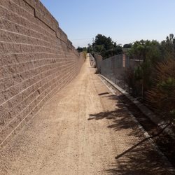
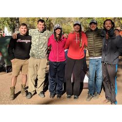
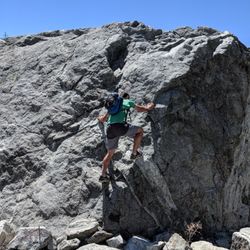
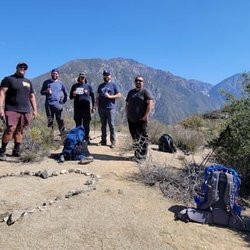
Joatngna Trailhead Photos


You might also consider
More like Joatngna Trailhead
Recommended Reviews - Joatngna Trailhead
Start your review...

This isn't your typical hiking trail but my dog and I absolutely love this hike! Not many hikes around the IE are dog friendly so I wanted to check this one out with our pup. Tip: Drive further up than the address that Yelp provides. You'll see some cars and cars parked on the side of the road. We've been parking there and it's been fine! There's a small stream of water which makes this so much fun. It's beautiful with lots of rocks, shrubs, and flat ground. You kind of just explore the area and come back when you're ready. My dog has never been happier. One thing I love is that there are not too many people. We've only seen 1-2 other groups there and that's about it. So we can really enjoy our time there! Highly recommend for dog owners. Just don't expect a trail because there isn't one! read more


3 years ago
Not a far drive at all. With the snowpack it was worrh wild. Pretty cool to get away from the city and get some one on one with yourself. read more

7 years ago
The Joatngna hiking trail is a short trail that makes its way up a scenic overlook, over looking the san antonio canyon. read more


6 years ago
More info about Joatngna Trailhead
2901 N Mountain Ave
Upland, CA 91784
Directions
Hours
Indoor Amenities
Outdoor Amenities
You might also consider


Joatngna Trailhead - hiking - Updated June 2026
Best of Upland
People found Joatngna Trailhead by searching for…
Hiking Trails in Upland, California
Walking Trails in Upland, California
Scenic Drive in Upland, California
Places to Take Pictures in Upland, California
Off Road Trails in Upland, California
Scenic Overlook in Upland, California
Dog Friendly Hiking Trails in Upland, California
Places to Walk Around in Upland, California
Easy Hikes in Upland, California
Things to Do in Upland, California
Running Trails in Upland, California
Dog Friendly Things to Do in Upland, California
Lookout Points in Upland, California
Beautiful Views in Upland, California
Scenic View in Upland, California
Hiking Club in Upland, California
Empty Parking Lot in Upland, California
Trending Searches in Upland, CA
Black Owned Nail Salons near Joatngna Trailhead
Boat Rental near Joatngna Trailhead
Cliff Jumping near Joatngna Trailhead
Day Trips near Joatngna Trailhead
Fishing Spots near Joatngna Trailhead
Jet Ski Rental near Joatngna Trailhead
Kayak Rental near Joatngna Trailhead
Lakes & Ponds near Joatngna Trailhead
Off Road Trails near Joatngna Trailhead
Outdoor Activities near Joatngna Trailhead
Places To Walk Around near Joatngna Trailhead
Public Shower near Joatngna Trailhead
River Swimming near Joatngna Trailhead
Rock Quarry near Joatngna Trailhead
Running Trails near Joatngna Trailhead
Scenic Night View near Joatngna Trailhead
Scenic Overlook near Joatngna Trailhead
Secluded Spots near Joatngna Trailhead
Soccer Store near Joatngna Trailhead
Splash Pad near Joatngna Trailhead
Strawberry Picking near Joatngna Trailhead
Sunrise View near Joatngna Trailhead
Swimming Holes near Joatngna Trailhead
Swimming Lakes near Joatngna Trailhead
U Pick Farms near Joatngna Trailhead
Watch Sunset near Joatngna Trailhead
Browse Articles
Browse Nearby
BEST of Upland, California Coffee near Joatngna Trailhead
BEST of Upland, California Restaurants near Joatngna Trailhead
BEST of Upland, California Things to Do near Joatngna Trailhead
BEST of Upland, California Parks near Joatngna Trailhead
BEST of Upland, California Breakfast near Joatngna Trailhead
BEST of Upland, California Lakes near Joatngna Trailhead
BEST of Upland, California Campgrounds near Joatngna Trailhead
BEST of Upland, California Ski Resorts near Joatngna Trailhead
Browse Brands
Related Searches in Upland, CA
Best Fishing Locations and Guides in Upland, California
Best Nature Trails for Hiking in Upland, California
Best Places for Horseback Riding in Upland, California
Best Sledding Spots and Fun in Upland, California
Check Out Off Road Trails in Upland, California
Discover Dog Friendly Trails to Explore in Upland, California
Discover Kid Friendly Hiking Trails in Upland, California
Discover Scenic Hiking Trails in Upland, California
Discover Scenic Mountain Bike Trails Near Upland, California
Discover Scenic Waterfall Spots in Upland, California
Discover Top Nature Parks to Visit in Upland, California
Discover Walking Parks in Upland, California Near You
Discover a Hiking Trail in Upland, California
Discover the Best Night Hike Trails in Upland, California
Dog-Friendly Hikes With Dogs in Upland, California
Enjoy Camping Adventures Around Upland, California
Enjoy Exciting Mountain Biking Adventures in Upland, California
Enjoy Kayaking Adventures in Upland, California
Enjoy Tent Camping Spots Around Upland, California
Enjoy a Beautiful Waterfall Hike in Upland, California
Enjoy a Peaceful Nature Walk in Upland, California
Enjoy the Best Walking Path in Upland, California
Enjoy the Best Walking Trails in Upland, California
Exciting Cliff Jumping Spots in Upland, California
Explore Beautiful Parks and Green Spaces in Upland, California
Explore Easy Hikes Perfect for All in Upland, California
Explore Fun Activities to Do in Upland, California
Explore Popular Campgrounds Near Upland, California
Explore the Best Swimming Holes Around Upland, California
Explore the Best Trail Options in Upland, California
Family Friendly Hiking With Kids in Upland, California
Find Beautiful Views in Upland, California
Find Popular Ziplining Spots Around Upland, California
Find the Best Parks for Picnics in Upland, California
Find the Best Scenic View Locations in Upland, California
Great Places to Walk in Upland, California
Hike the Popular Waterfall Trail in Upland, California
Hiking Trails With Waterfalls in Upland, California
Off Leash Dog Hiking Trails in Upland, California
Plan a Scenic Drive Route Near Upland, California
Popular Outdoor Activities to Try in Upland, California
Popular Picnic Spots to Visit in Upland, California
Safe River Swimming Areas in Upland, California
Safe and Fun Parks for Kids in Upland, California
Top Climbing Spots and Gyms in Upland, California
Top Running Trails to Explore in Upland, California
Top Swimming Lakes to Enjoy in Upland, California
Top Swimming Spots and Pools in Upland, California
People who viewed Joatngna Trailhead also viewed
Potato Mountain
144 reviews
Bridle Path
24 reviews
North Etiwanda Preserve
306 reviews
Cucamonga Peak
109 reviews
Etiwanda Falls Trail
58 reviews
Pacific Electric Trail - Route 66 Trailhead
4 reviews
Pacific Electric Inland Empire Trail
73 reviews
San Antonio Falls
66 reviews
The Uplands Trail
1 review
La Sierra Trail Loop
73 reviews