Bridle Path Photos


You might also consider
More like Bridle Path
Recommended Reviews - Bridle Path
Start your review...

Reviews With Photos

Ye Bridle Path is a good compromise between hiking in nature with nice views while not traveling very far. I've parked at Chase bank at the beginning of the trail but most times I start up higher on 19th street and park at the school on weekends. The path is a wide dirt path in the middle of the street with plenty of trees and shade. There's benches throughout the path as well as drinking fountains for humans and dogs. The hike up is safe for the most part and requires no real hiking experience. It's great for people of all levels, kids, etc. The view of the homes that get progressively bigger and more elaborate as you hike closer to the top are breathtaking. Once at the base of the mountain it feels like an accomplishment. The trek down goes a lot faster and is very relaxing at the end. It's about 5 miles total to hike up and back to the start.

If you are not the athletic type, this is a very nice place for a stroll/walk, and if you are, then go ahead and show off as you run uphill--huffing and puffing all the way. Not off the beaten path or secluded like some of the other local trails so there's no need to pack a survivalist kit. It's right smack dab in the middle of Euclid Avenue. A water fountain or two along the way if you need water, and some benches if you poop out or just want to admire some of the cool looking houses. The further north you get, the more serene it becomes. Earlier in the morning is also a better time. Pretty noisy and lots of traffic down at the south end off Foothill until you get just past 16th St. Our beagles enjoy this walk and don't get weirded out by coyotes and critters that stalk us in other areas that are more like hiking trails/wilderness. So many trees, so little time to smell and pee on! This was Ramsay's choice for his Birfday outing this past weekend. He tagged as many trees as possible!

I really love this walking path. If weren't 12 miles (one way) from my house it would be absolutely perfect! I used to walk the entire 6 miles with a girlfriend once a week but it gets way too hot in the summer. Now I walk 3 miles round trip by myself 2 or 3x a week. This is the only walk I have found that is completely safe to walk alone and that's what I love about it. It's right in the center of a busy Street, it's lined with beautiful willow trees and plenty of people walking alone but never so many that it's crowded. I love walkin uphill first and then downhill on the return. No wild animals, no creepy snakes, no weirdos... PERFECT for me!

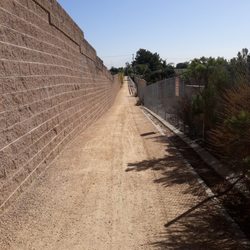
Always a tranquil walk, the Bridle Path is a 3-mile trail from Foothill Ave to 24th Street, in between the N Euclid median. The trailhead is the Madonna of the Trail monument, the visibly recognized yet often ignored monument "dedicated to the spirit of pioneer women in the United States" (Wikipedia). The path aptly starts at Foothill Blvd for it graciously ascends towards the foothills of the San Gabriel Mountains, yet stops short. The North Euclid median is lined by Pepper trees street-side along the entire 3 mile stretch, offering a cool shade for those afternoon runs or walks. Most people walk, some run, and a few will ride horseback. A note to runners: be keen of the path you run on because the ground is uneven, especially the first mile. It would be to the benefit of the community if the trail was tended to by the city of Upland by removing the old asphalt and leveling the trail altogether. Look no further than to the Pacific Electric trail for an exemplary trail. A few benches line the trail and a water fountain is located at 13th Street and 17th Street. There are mile markers though the one mile marker was knocked over and pending a replacement. Coyotes roam in the early and late hours, but they are quick to scurry on. I prefer a morning walk along the trail because there is minimal noise pollution. Whatever the time of day, squeeze in a little physical activity along this beautiful stretch of Upland.

Love this trail! I feel safe it's out in the open. Though you hear and see many cars go by, you become in a different place in between all the beautiful trees. They have benches and water fountains. A trolley use to run this path and city picnics were held. I always think of the history of this trail/path. Love it!


Bridle Path?? Growing up I have always called this "that one trail on Euclid." Due to the Covid-19 shut down on the fitness industry, my hometown friend and I happen to both be in Upland at the same time and we have met up a few time for some "distanced" walks. I just carry a little backpack so I can keep my keys, 32oz of water, id, credit card and HAND SANITIZER :) 2020 problems!! This is an easy chill walk with low key elevation starting from Foothill Blvd to 24th Street, which is slightly less than 6 miles round trip. You walk between the tall plushy trees off Euclid Ave, so there is plenty of shade. This is definitely a very family environment trail with kids and pets. There is a lot of loose dirt on the trail, so don't wear any shoes that are precious. Or in my case... don't wear pink flip flops :) It wasn't bad but I was just dirty after... When you get to the fire station on 24th, you know you have reached the midpoint and the second half is an easy downhill chill walk. Next to the fire station on 24th is a gas station with a small selection of beverages if you need a water break. Or a special ICE CREAM treat to reward yourself on the way back ;) Its FREE, so don't expect too much. It's convenient for me so I am sure my hometown friend and I will be back. read more


This is my favorite trail to walk. It wasn't always my favorite because it's a really good incline to the top and quiet the leg workout! It's 6 miles round trip. It's got a slow but steady incline that will leave our legs quivering at the end. Its full of friendly people and I feel safe walking here. It's not the quiet trail by any means, as there are cars zooming in and down Euclid constantly. You may even get a honk or two on your walk and maybe a whistle. At the top is San Antonio Fire Station with great views of the mountains. Early to mid morning the trail is pretty shaded. Often times there is a light breeze. On some cloudy days once you get above the 210 you might feel a little mist. There are water spigots for dogs, and drinking fountains for you. There are a few benches to take a rest and or just people watch. A few things to keep in mind. The trail is uneven in some parts, other parts it's a bit rocky. But it's doable by feet, bike & stroller. Once you get to 20th street thee is a nasty sewer smell most days. You will have to pay attention at street crossings for cars. I've been nearly hit once by a woman not paying attention. It's a great workout and if you haven't tried it yet you should! Just don't tell your friends about it. Ha! read more

Ye Bridle Path is a good compromise between hiking in nature with nice views while not traveling very far. I've parked at Chase bank at the beginning of the trail but most times I start up higher on 19th street and park at the school on weekends. The path is a wide dirt path in the middle of the street with plenty of trees and shade. There's benches throughout the path as well as drinking fountains for humans and dogs. The hike up is safe for the most part and requires no real hiking experience. It's great for people of all levels, kids, etc. The view of the homes that get progressively bigger and more elaborate as you hike closer to the top are breathtaking. Once at the base of the mountain it feels like an accomplishment. The trek down goes a lot faster and is very relaxing at the end. It's about 5 miles total to hike up and back to the start. read more

6 years ago
If you are not the athletic type, this is a very nice place for a stroll/walk, and if you are, then go ahead and show off as you run uphill--huffing and puffing all the way. Not off the beaten path or secluded like some of the other local trails so there's no need to pack a survivalist kit. It's right smack dab in the middle of Euclid Avenue. A water fountain or two along the way if you need water, and some benches if you poop out or just want to admire some of the cool looking houses. The further north you get, the more serene it becomes. Earlier in the morning is also a better time. Pretty noisy and lots of traffic down at the south end off Foothill until you get just past 16th St. Our beagles enjoy this walk and don't get weirded out by coyotes and critters that stalk us in other areas that are more like hiking trails/wilderness. So many trees, so little time to smell and pee on! This was Ramsay's choice for his Birfday outing this past weekend. He tagged as many trees as possible! read more


10 years ago
I really love this walking path. If weren't 12 miles (one way) from my house it would be absolutely perfect! I used to walk the entire 6 miles with a girlfriend once a week but it gets way too hot in the summer. Now I walk 3 miles round trip by myself 2 or 3x a week. This is the only walk I have found that is completely safe to walk alone and that's what I love about it. It's right in the center of a busy Street, it's lined with beautiful willow trees and plenty of people walking alone but never so many that it's crowded. I love walkin uphill first and then downhill on the return. No wild animals, no creepy snakes, no weirdos... PERFECT for me! read more


Always a tranquil walk, the Bridle Path is a 3-mile trail from Foothill Ave to 24th Street, in between the N Euclid median. The trailhead is the Madonna of the Trail monument, the visibly recognized yet often ignored monument "dedicated to the spirit of pioneer women in the United States" (Wikipedia). The path aptly starts at Foothill Blvd for it graciously ascends towards the foothills of the San Gabriel Mountains, yet stops short. The North Euclid median is lined by Pepper trees street-side along the entire 3 mile stretch, offering a cool shade for those afternoon runs or walks. Most people walk, some run, and a few will ride horseback. A note to runners: be keen of the path you run on because the ground is uneven, especially the first mile. It would be to the benefit of the community if the trail was tended to by the city of Upland by removing the old asphalt and leveling the trail altogether. Look no further than to the Pacific Electric trail for an exemplary trail. A few benches line the trail and a water fountain is located at 13th Street and 17th Street. There are mile markers though the one mile marker was knocked over and pending a replacement. Coyotes roam in the early and late hours, but they are quick to scurry on. I prefer a morning walk along the trail because there is minimal noise pollution. Whatever the time of day, squeeze in a little physical activity along this beautiful stretch of Upland. read more


11 years ago
Love this trail! I feel safe it's out in the open. Though you hear and see many cars go by, you become in a different place in between all the beautiful trees. They have benches and water fountains. A trolley use to run this path and city picnics were held. I always think of the history of this trail/path. Love it! read more

8 years ago
8 years ago
12 years ago
I had a lot of fun walking this path and looking at all the beautiful houses around it!! It is nice to go very early in the morning so you don't have to hear the sounds of moving cars (: the directions off of yelp take you to Arrow St. but it really is on Foothill! read more

10 years ago
I live close by so I decided to cancel my gym membership and walk/jog over here. It's a good 5 mile from my house to Bridle Path back and forth. read more

8 years ago
What a beautiful and historic street. Euclid ave starts in Chino and runs north all the way to the city of Upland. Many years ago there was a trolly track that ran up Euclid ave, starting in Ontario and ending in Upland. It was actually all Ontario until they decided to change North Ontario to Upland. The trolly was pulled by a mule, and when the trolly reached North Ontario the mule would hop on the back and ride back down. The bridle path starts at the historic monument Madonna of the Trail. One in a series of 12 monuments dedicated to the spirit of pioneer women in the United States, and runs to the top of Euclid ending at 24th street. The dirt path is lined with beautiful trees and beautiful houses on both sides. Anytime of the day you will see people running, walking, and pushing strollers. There are even people riding their horses on the trail. This trail is all uphill and the incline seems to increase around 21st. Just an overall great historic trail. read more


11 years ago
9 years ago
11 years ago
12 years ago
11 years ago
11 years ago
11 years ago
11 years ago
12 years ago
More info about Bridle Path
N Euclid Ave
Upland, CA 91786
Directions
Hours
Payment methods
Outdoor Amenities
Ask the Community - Bridle Path
Review Highlights - Bridle Path
You might also consider


Bridle Path - hiking - Updated June 2026
Best of Upland
People found Bridle Path by searching for…
Hiking Trails in Upland, California
Walking Trails in Upland, California
Beautiful Views in Upland, California
Running Trails in Upland, California
Places to Take Pictures in Upland, California
Scenic View in Upland, California
Scenic Drive in Upland, California
Photo Spots in Upland, California
Secret Spots in Upland, California
Things to Do With Kids in Upland, California
Dog Friendly Hiking Trails in Upland, California
Places to Walk Around in Upland, California
Hiking With Kids in Upland, California
Horse Rental in Upland, California
Easy Hikes in Upland, California
Equestrian Center in Upland, California
Sunset View in Upland, California
Scenic Overlook in Upland, California
Stroller Walk in Upland, California
Bike Paths in Upland, California
Trending Searches in Upland, CA
Black Owned Nail Salons near Bridle Path
Cliff Jumping near Bridle Path
Fishing Spots near Bridle Path
Jet Ski Rental near Bridle Path
Lakes & Ponds near Bridle Path
Off Road Trails near Bridle Path
Outdoor Activities near Bridle Path
Places To Walk Around near Bridle Path
Public Shower near Bridle Path
River Swimming near Bridle Path
Running Trails near Bridle Path
Scenic Night View near Bridle Path
Scenic Overlook near Bridle Path
Secluded Spots near Bridle Path
Strawberry Picking near Bridle Path
Swimming Holes near Bridle Path
Browse Articles
Browse Nearby
BEST of Upland, California Coffee near Bridle Path
BEST of Upland, California Restaurants near Bridle Path
BEST of Upland, California Things to Do near Bridle Path
BEST of Upland, California Walking Trails near Bridle Path
BEST of Upland, California Parks near Bridle Path
BEST of Upland, California Breakfast near Bridle Path
BEST of Upland, California Hot Springs near Bridle Path
Browse Brands
Related Searches in Upland, CA
Affordable Horse Boarding Services in Upland, California
Affordable Horse Rental Options in Upland, California
Affordable Pony Rental Services Available in Upland, California
Best Fishing Locations and Guides in Upland, California
Best Nature Trails for Hiking in Upland, California
Best Places for Horseback Riding in Upland, California
Best Sledding Spots and Fun in Upland, California
Book English Riding Lessons Near You in Upland, California
Book Equestrian Lessons With Experts in Upland, California
Book Expert Dressage Lessons in Upland, California
Check Out Off Road Trails in Upland, California
Discover Dog Friendly Trails to Explore in Upland, California
Discover Effective Equine Therapy Options in Upland, California
Discover Equestrian Centers Around Upland, California
Discover Fun Activities to Do in Upland, California
Discover Horseback Riding Tours in Upland, California
Discover Kid Friendly Hiking Trails in Upland, California
Discover Scenic Hiking Trails in Upland, California
Discover Scenic Mountain Bike Trails Near Upland, California
Discover Scenic Waterfall Spots in Upland, California
Discover Top Nature Parks to Visit in Upland, California
Discover Top-Rated Dude Ranch Experiences in Upland, California
Discover Walking Parks in Upland, California Near You
Discover a Hiking Trail in Upland, California
Discover the Best Night Hike Trails in Upland, California
Dog-Friendly Hikes With Dogs in Upland, California
Enjoy Camping Adventures Around Upland, California
Enjoy Exciting Mountain Biking Adventures in Upland, California
Enjoy Hiking Adventures in Upland, California
Enjoy Horseback Riding on Beach in Upland, California
Enjoy Kayaking Adventures in Upland, California
Enjoy Petting Zoo Pony Rides Around Upland, California
Enjoy Stables and Horse Riding Experiences in Upland, California
Enjoy Tent Camping Spots Around Upland, California
Enjoy Thrilling Atv Riding Experiences in Upland, California
Enjoy a Beautiful Waterfall Hike in Upland, California
Enjoy a Memorable Pony Ride in Upland, California Today
Enjoy a Peaceful Nature Walk in Upland, California
Enjoy the Best Walking Path in Upland, California
Enjoy the Best Walking Trails in Upland, California
Exciting Cliff Jumping Spots in Upland, California
Experience Exciting Horse Racing in Upland, California
Experience Top Dressage Events in Upland, California
Explore Beautiful Parks and Green Spaces in Upland, California
Explore Bike Rentals Throughout Upland, California
Explore Easy Hikes Perfect for All in Upland, California
Explore Equestrian Activities and Services in Upland, California
Explore Fun Activities to Do in Upland, California
People who viewed Bridle Path also viewed
Cucamonga Creek Trail
8 reviews
Thompson Creek Road Trail
35 reviews
Pacific Electric Trail
19 reviews
Joatngna Trailhead
5 reviews
Claremont Hills Wilderness Park
472 reviews
Johnson's Pasture
18 reviews
Frankish Peak Hike
9 reviews
San Antonio Park
5 reviews
Marshall Canyon Regional Park
40 reviews
Conservation Park
3 reviews