Frankish Peak Hike Photos


You might also consider
More like Frankish Peak Hike
Recommended Reviews - Frankish Peak Hike
Start your review...

Reviews With Photos

This hike is 14 miles roundtrip with 2,794' elevation gain/loss starting from the Stoddard Barrett parking lot. It's not a difficult hike, in terms of a killer incline/workout, but it does require a lot of endurance and about 6 hours of your time. The trail is fairly wide a good portion of the way with some loose rocks under foot. Some of the trail, though, does have high brush. At the turn to go up to Stoddard Peak, continue straight instead. Most of the way to Frankish Peak, the hike is actually pretty easy. It won't seem like it, but most of the way there is a pretty steady, gentle decline. It is a pretty and meandering hike to get to the peak. About a mile or so before reaching the peak, there will be an option to go right or left. Go right and continue to ascend. You will see an option to go right, around the peak to get to the top, OR, go straight up. This will be the killer portion of the hike if you choose it. And it is REALLY TOUGH! If you go this route, once you get to the top, this is not Frankish, even though it will seem like it is. In the distance a few hundred feet more, you will see another peak at about the same elevation. Continue on to reach Frankish Peak. On the return, most of the way back toward Stoddard will be at an incline. It's not a tough climb, but the distance of the hike will make it seem tougher than it really should be. Make sure to stay well hydrated. parking - adventure pass required

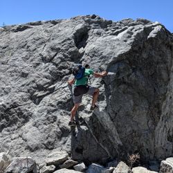
Distance: 4.26 miles Elevation Gain: 1927ft Total Elevation Gain/Loss: 2014ft / -178ft Difficulty: 7/10 Here is all you need to know to get to the top of Frankish Peak. I would say after conquering Potato Mountain, this is the next hike to do. Unlike Potato Mountain, this hike does not attract very high traffic and is not as well maintained. Just the kind of trails I like. The trail head is located on the left 2200ft north from the intersection of Mountain ave and Euclid. Parking here does not require an Adventure pass. The trail starts directly north of you to the right of the yellow gate, Yes, you will be going up that. In 350 feet, the trail will level to a small clearing, Continue north east on the single track for 0.5mi. Here you will see in intersection, you will want to head EAST which is to your RIGHT. Travel on the fire road until you reach a second intersection, Here you will want to travel WEST which is LEFT. Continue for another 1000ft and you will reach a rather large clearing. Here is where the fun starts! Directly NORTH of you lies the trail that you will follow. It is for all intents and purposes a user made traffic trail; easily missed. and easier to loose. Go slow and pay attention to your surroundings. There are several places where there are rocky drops on ether side. This trail lasts for 1.07mi, at this point you will reach a fire road. Your path awaits to the EAST. Continue for roughly 1000ft and you'll have arrived at Frankish Peak. Return the way you came!.

2 years ago
I did this hike last month in April. We were lucky to do it with good weather. Also, we started this hike from the northern side where the Stoddard Peak trailhead is located. We started the hike early too, which always helps with a hike of this distance. We started at 5 AM and hiked to Stoddard Peak which is a beautiful and pretty easy hike. We then continued on the main trail south toward Frankish Peak. I have to be honest and admit that I had never heard of this trail until the weak before when I got the invite from one of my hiker friends to join a group of hikers to do this one. We hiked for another 2.5 miles and then reached an area where there are some connected trails and this area was beautiful and we didn't encounter any hikers/mountain bikers during the first half of this hike. At this point we had to make a decision to take a trail way out to the east that looked to be a longer route to Frankish Peak or what looked like a more direct, steeper trail to the peak. We opted for the shorter route...problem was it looked like a trail on the map and looked like it may have actually been a trail at one time but this trail has not been maintained or used by the looks of it in may years. We had to walk through sharp shrubbery and even had to get on our hands and knees and crawl under the brush for portions of the last mile to the peak...most of this last mile was also rather steep. We were also a bit disappointed to not find anything that officially looked like we were at the top of Frankish Peak. We stayed for a while on what looked like the peak according to the map and we also made our way to another high flat area nearby where we found a box with some hiking stickers that might indicate that was the peak. On the way back, we took the longer trail that was better maintained and not as hard Distance- from the Stoddard trailhead to Stoddard Peak and Frankish Peak and back to the parking lot was about 14 miles Duration- I would estimate it to take around 7 to 8 hours of your time including time to eat, take pictures, etc... Difficulty- hard not necessarily due to the overall elevation gain but mainly due to the pieces of steep, rocky stretches and the overall length of 14 miles read more


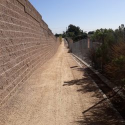
EASY TO MISS, it's not far past the Mountain Ave and Euclid Ave intersection but if you keep going past that intersection on Mountain the trial head is UNMARKED on your RIGHT hand side JUST PAST the water tower! the trial head starts with a STEEP hill with a bunch of broken bricks (which is to the left of a yellow gate). you can park in the dirt area to the side of the road the hike is short but ALL INCLINE, and at some points we had to use our hands just a little to brace ourselves onto the rocks. we weren't able to reach the END of the trial because the wind started blowing so hard it was no longer safe to hike, but we were at the top! views aren't that amazing but it was definitely worth the uphill work out NOTE: don't get confused with the 2 yellow gates BEFORE the water tower because they aren't it! read more

11 years ago
This hike is 14 miles roundtrip with 2,794' elevation gain/loss starting from the Stoddard Barrett parking lot. It's not a difficult hike, in terms of a killer incline/workout, but it does require a lot of endurance and about 6 hours of your time. The trail is fairly wide a good portion of the way with some loose rocks under foot. Some of the trail, though, does have high brush. At the turn to go up to Stoddard Peak, continue straight instead. Most of the way to Frankish Peak, the hike is actually pretty easy. It won't seem like it, but most of the way there is a pretty steady, gentle decline. It is a pretty and meandering hike to get to the peak. About a mile or so before reaching the peak, there will be an option to go right or left. Go right and continue to ascend. You will see an option to go right, around the peak to get to the top, OR, go straight up. This will be the killer portion of the hike if you choose it. And it is REALLY TOUGH! If you go this route, once you get to the top, this is not Frankish, even though it will seem like it is. In the distance a few hundred feet more, you will see another peak at about the same elevation. Continue on to reach Frankish Peak. On the return, most of the way back toward Stoddard will be at an incline. It's not a tough climb, but the distance of the hike will make it seem tougher than it really should be. Make sure to stay well hydrated. parking - adventure pass required read more


13 years ago
Distance: 4.26 miles Elevation Gain: 1927ft Total Elevation Gain/Loss: 2014ft / -178ft Difficulty: 7/10 Here is all you need to know to get to the top of Frankish Peak. I would say after conquering Potato Mountain, this is the next hike to do. Unlike Potato Mountain, this hike does not attract very high traffic and is not as well maintained. Just the kind of trails I like. The trail head is located on the left 2200ft north from the intersection of Mountain ave and Euclid. Parking here does not require an Adventure pass. The trail starts directly north of you to the right of the yellow gate, Yes, you will be going up that. In 350 feet, the trail will level to a small clearing, Continue north east on the single track for 0.5mi. Here you will see in intersection, you will want to head EAST which is to your RIGHT. Travel on the fire road until you reach a second intersection, Here you will want to travel WEST which is LEFT. Continue for another 1000ft and you will reach a rather large clearing. Here is where the fun starts! Directly NORTH of you lies the trail that you will follow. It is for all intents and purposes a user made traffic trail; easily missed. and easier to loose. Go slow and pay attention to your surroundings. There are several places where there are rocky drops on ether side. This trail lasts for 1.07mi, at this point you will reach a fire road. Your path awaits to the EAST. Continue for roughly 1000ft and you'll have arrived at Frankish Peak. Return the way you came!. read more

7 years ago
A little steep at times. had to turn back cause of the weather, going back down was something i didnt plan. had to take my time going back down read more


13 years ago
11 years ago
9 years ago
More info about Frankish Peak Hike
2798 N Mountain Ave
Upland, CA 91784
Directions
Visit Website
http://nobodyhikesinla.com
Hours
Outdoor Amenities
Ask the Community - Frankish Peak Hike
You might also consider


Frankish Peak Hike - hiking - Updated July 2026
Best of Upland
People found Frankish Peak Hike by searching for…
Trending Searches in Upland, CA
Black Owned Nail Salons near Frankish Peak Hike
Boat Rental near Frankish Peak Hike
Cliff Jumping near Frankish Peak Hike
Day Trips near Frankish Peak Hike
Jet Ski Rental near Frankish Peak Hike
Kayak Rental near Frankish Peak Hike
Lakes & Ponds near Frankish Peak Hike
Off Road Trails near Frankish Peak Hike
Outdoor Activities near Frankish Peak Hike
Picnic Spots near Frankish Peak Hike
Places To Swim near Frankish Peak Hike
Places To Walk Around near Frankish Peak Hike
Pool Day Pass near Frankish Peak Hike
Public Pools near Frankish Peak Hike
Public Shower near Frankish Peak Hike
River Swimming near Frankish Peak Hike
River Tubing near Frankish Peak Hike
Rock Quarry near Frankish Peak Hike
Running Trails near Frankish Peak Hike
Scenic Night View near Frankish Peak Hike
Scenic Overlook near Frankish Peak Hike
Soccer Store near Frankish Peak Hike
Splash Pad near Frankish Peak Hike
Sunrise View near Frankish Peak Hike
Swimming Holes near Frankish Peak Hike
Swimming Lakes near Frankish Peak Hike
Watch Sunset near Frankish Peak Hike
Browse Articles
Browse Nearby
BEST of Upland, California Coffee near Frankish Peak Hike
BEST of Upland, California Restaurants near Frankish Peak Hike
BEST of Upland, California Things to Do near Frankish Peak Hike
BEST of Upland, California Parks near Frankish Peak Hike
BEST of Upland, California Breakfast near Frankish Peak Hike
BEST of Upland, California Lakes near Frankish Peak Hike
BEST of Upland, California Campgrounds near Frankish Peak Hike
BEST of Upland, California Ski Resorts near Frankish Peak Hike
Browse Brands
Related Searches in Upland, CA
Best Fishing Locations and Guides in Upland, California
Best Nature Trails for Hiking in Upland, California
Best Places for Horseback Riding in Upland, California
Best Sledding Spots and Fun in Upland, California
Check Out Off Road Trails in Upland, California
Discover Dog Friendly Trails to Explore in Upland, California
Discover Kid Friendly Hiking Trails in Upland, California
Discover Scenic Hiking Trails in Upland, California
Discover Scenic Mountain Bike Trails Near Upland, California
Discover Scenic Waterfall Spots in Upland, California
Discover Top Nature Parks to Visit in Upland, California
Discover Walking Parks in Upland, California Near You
Discover a Hiking Trail in Upland, California
Discover the Best Night Hike Trails in Upland, California
Dog-Friendly Hikes With Dogs in Upland, California
Enjoy Camping Adventures Around Upland, California
Enjoy Exciting Mountain Biking Adventures in Upland, California
Enjoy Kayaking Adventures in Upland, California
Enjoy Tent Camping Spots Around Upland, California
Enjoy a Beautiful Waterfall Hike in Upland, California
Enjoy a Peaceful Nature Walk in Upland, California
Enjoy the Best Walking Path in Upland, California
Enjoy the Best Walking Trails in Upland, California
Exciting Cliff Jumping Spots in Upland, California
Explore Beautiful Parks and Green Spaces in Upland, California
Explore Easy Hikes Perfect for All in Upland, California
Explore Fun Activities to Do in Upland, California
Explore Popular Campgrounds Near Upland, California
Explore the Best Swimming Holes Around Upland, California
Explore the Best Trail Options in Upland, California
Family Friendly Hiking With Kids in Upland, California
Find Beautiful Views in Upland, California
Find Popular Ziplining Spots Around Upland, California
Find the Best Parks for Picnics in Upland, California
Find the Best Scenic View Locations in Upland, California
Great Places to Walk in Upland, California
Hike the Popular Waterfall Trail in Upland, California
Hiking Trails With Waterfalls in Upland, California
Off Leash Dog Hiking Trails in Upland, California
Plan a Scenic Drive Route Near Upland, California
Popular Outdoor Activities to Try in Upland, California
Popular Picnic Spots to Visit in Upland, California
Safe River Swimming Areas in Upland, California
Safe and Fun Parks for Kids in Upland, California
Top Climbing Spots and Gyms in Upland, California
Top Running Trails to Explore in Upland, California
Top Swimming Lakes to Enjoy in Upland, California
Top Swimming Spots and Pools in Upland, California