La Sierra Trail Loop Photos


You might also consider
More like La Sierra Trail Loop
Recommended Reviews - La Sierra Trail Loop
Start your review...

Reviews With Photos


Beautiful hike during the spring. You will find yellow wildflowers blooming and mustard grass everywhere. You can also get a nice view of the sunset and snow caps on the mountain from afar. This trail is easy-moderate. It can take you 45-1hr to complete the loop. And has a steep rocky hill (going down). If you're also not a fan of gnats I suggest to bring a wide brim sun hat with a protective face cover. They tend to group up near the bottom of the path where the water runs. Parking is available in the residential area. Note: There is also a fork near the end of the trail where you can take a longer route.


This trail is my ultimate happy place! Thank goodness I live in the neighborhood, so I'm able to take a walk here whenever I want. The trail is quite difficult because there are many inclines, and it is pretty long. However, the hiking experience is worth it because the scenery is just breathtaking. You'll be able to see rolling green hills, snow-capped mountains, and fields of flowers and vegetation. As always, wear comfortable tennis shoes or hiking boots and always carry a bottle of water along with other hiking essentials. And most definitely, your smartphone because you'll want to capture many scenic photos!

Moderate hiking trail in Chino Hills with some steep climbs. Came here on a Saturday around 10am and it was already pretty hot (gotta love SoCal summers). The trail is exposed and there's minimal shade so wear sunblock and bring a lot of water. There were some cyclists but the majority of people we saw were hikers. I'd suggest wearing hiking books since some parts of the trail were a bit slippery, but you could get by with sneakers. Parking is available at the park and you can take the trailhead underneath an overpass which branches out in a couple of different directions. Bathrooms are available at the park, not along the trail. There were two or three benches at certain points in the trail but only one was underneath a tree with shade. You do need to cross the street at one point in the trail if you want to continue onward and make it a loop. Otherwise, it can easily be made into an out and back.


Plenty of street parking on a Sunday morning. Pretty decent 2 mile hike that took about 45 minutes. In addition, the trails are marked well with signs so it was easy to complete the loop. There are some inclines and declines but wasn't too bad. There's another trail in here called the Monteverde Trail if you wanted to add another 1.6 miles (no loop). There were some annoying flies so you could bring some bug repellent. Furthermore, there was a dead snake on the side of the street where people park so be careful out there.

A very nice short hiking trail. The whole loop is around 2 miles for an easy hike. The entrance to this trial is located at a cul de sac residential area. Park on the street and enter the trail on the hill. It was a gorgeous day on a Wednesday when we visited the trail. We wanted to take some pictures of the blooming wild flowers. Originally, we were planing to visit the Chino Hill State Park, but not much flowers there yet. Maybe another week or so before we will be seeing flowers there. The best place to take photos with flowers on the hill is near the entrance. With rolling hills and puffy clouds, the scenery is picture perfect. Another photo taking point is near the top of the hill where you can see the distance mountains with snow caps. The picturesque scene of the mountains is breathtaking. When we were there on Wednesday this week ( 2/23/2022), the clouds were spectacular covering the mountains. I have never seen anything like it. If you're in the area and thinking about a short hike, this would be a pleasant trail to pay a visit.

First time hiking in this trail. Because of the rain season we have this year.. The Yellow wild flowers are blooming. Spring is here.. People burning fat and enjoy nature and rattle snake are awake! Trail is not hard. At the end it is a little work out.. Will burn some fat but it's not to the point you want to die. Bring water.. No shade so you can get dehydrated after the hike. Tip: 1. walk in the middle since rattle snake might be hiding near the flowers. 2. Watch your steps Almost got attack by a baby rattle snake. Good thing my brother in law warned me as I was busy running down the trail. Be careful when hiking especially going with little kids. they like to explore or walk near the edge.of the trail

Had no idea this trail was so nearby ! This is my second time stopping by in the past couple of weeks to get my heart rate up. There are lots of cute little lizards running around and there is a lot of dry brush. If you're looking for a moderate hike in the area with plenty of steep hills this is the one for you. Just be sure to be cautious and social distance as I noticed during my hike today that many people are out on the trails.


Came on an overcast day and it was perfect. I can imagine it being very hot in summer days due to no shade. Trail is about 2 miles, very straightforward. We followed the arrow on the trail marker, and it was basically a mile down and a gradual increase with one steeper climb towards the end. Easy neighborhood street parking. Dog friendly. Bonus that spring flowers are blooming now.

Saw the most amazing sunrise from this trail! You should check the exact time of the sunrise online- it totally changes depending on the time of year! Chino Hills has such an amazing collection of trails but this one is one of the highlights. The best way to get a good sunrise also depends on the season- generally you'll enjoy a summer sunrise if you're a late-riser but it's worth getting up early in the winter for that crisp feel. The worst thing is if you get up early and it's a super foggy day! But that's a very game of thrones, dramatic early rise so it'll be well worth your efforts and that cup of coffee regardless. :) Make sure you try to bring a good quality camera- DSLR is bulky but worth the climb, otherwise if you're on a run a good iphone camera should suffice!

3 months ago
My favorite trail to hike. You'll catch me here often on weekends. Sometimes during the week because it's such a beautiful and peaceful place to be. read more

2 months ago
Such a beautiful trail! Came during sunset. There was a good number of people around so felt very safe as well. Around 2 miles, not too steep in my opinion. Very nice and peaceful walk with some incline. Plenty of street parking. read more


1 year ago
Great hike! It's a rattlesnake haven! I do enjoy hiking here but know I need to stay alert because of the wildlife. read more


Beautiful hike during the spring. You will find yellow wildflowers blooming and mustard grass everywhere. You can also get a nice view of the sunset and snow caps on the mountain from afar. This trail is easy-moderate. It can take you 45-1hr to complete the loop. And has a steep rocky hill (going down). If you're also not a fan of gnats I suggest to bring a wide brim sun hat with a protective face cover. They tend to group up near the bottom of the path where the water runs. Parking is available in the residential area. Note: There is also a fork near the end of the trail where you can take a longer route. read more

2 years ago
Beautiful trail in Chino hills, super quiet and dog friendly. No shades but that's ok, easy walk! read more


1 year ago
3 years ago
This trail is my ultimate happy place! Thank goodness I live in the neighborhood, so I'm able to take a walk here whenever I want. The trail is quite difficult because there are many inclines, and it is pretty long. However, the hiking experience is worth it because the scenery is just breathtaking. You'll be able to see rolling green hills, snow-capped mountains, and fields of flowers and vegetation. As always, wear comfortable tennis shoes or hiking boots and always carry a bottle of water along with other hiking essentials. And most definitely, your smartphone because you'll want to capture many scenic photos! read more


5 years ago
Moderate hiking trail in Chino Hills with some steep climbs. Came here on a Saturday around 10am and it was already pretty hot (gotta love SoCal summers). The trail is exposed and there's minimal shade so wear sunblock and bring a lot of water. There were some cyclists but the majority of people we saw were hikers. I'd suggest wearing hiking books since some parts of the trail were a bit slippery, but you could get by with sneakers. Parking is available at the park and you can take the trailhead underneath an overpass which branches out in a couple of different directions. Bathrooms are available at the park, not along the trail. There were two or three benches at certain points in the trail but only one was underneath a tree with shade. You do need to cross the street at one point in the trail if you want to continue onward and make it a loop. Otherwise, it can easily be made into an out and back. read more


Plenty of street parking on a Sunday morning. Pretty decent 2 mile hike that took about 45 minutes. In addition, the trails are marked well with signs so it was easy to complete the loop. There are some inclines and declines but wasn't too bad. There's another trail in here called the Monteverde Trail if you wanted to add another 1.6 miles (no loop). There were some annoying flies so you could bring some bug repellent. Furthermore, there was a dead snake on the side of the street where people park so be careful out there. read more


A very nice short hiking trail. The whole loop is around 2 miles for an easy hike. The entrance to this trial is located at a cul de sac residential area. Park on the street and enter the trail on the hill. It was a gorgeous day on a Wednesday when we visited the trail. We wanted to take some pictures of the blooming wild flowers. Originally, we were planing to visit the Chino Hill State Park, but not much flowers there yet. Maybe another week or so before we will be seeing flowers there. The best place to take photos with flowers on the hill is near the entrance. With rolling hills and puffy clouds, the scenery is picture perfect. Another photo taking point is near the top of the hill where you can see the distance mountains with snow caps. The picturesque scene of the mountains is breathtaking. When we were there on Wednesday this week ( 2/23/2022), the clouds were spectacular covering the mountains. I have never seen anything like it. If you're in the area and thinking about a short hike, this would be a pleasant trail to pay a visit. read more


3 years ago
2 years ago
2 years ago
2 years ago
7 years ago
First time hiking in this trail. Because of the rain season we have this year.. The Yellow wild flowers are blooming. Spring is here.. People burning fat and enjoy nature and rattle snake are awake! Trail is not hard. At the end it is a little work out.. Will burn some fat but it's not to the point you want to die. Bring water.. No shade so you can get dehydrated after the hike. Tip: 1. walk in the middle since rattle snake might be hiding near the flowers. 2. Watch your steps Almost got attack by a baby rattle snake. Good thing my brother in law warned me as I was busy running down the trail. Be careful when hiking especially going with little kids. they like to explore or walk near the edge.of the trail read more

6 years ago
Had no idea this trail was so nearby ! This is my second time stopping by in the past couple of weeks to get my heart rate up. There are lots of cute little lizards running around and there is a lot of dry brush. If you're looking for a moderate hike in the area with plenty of steep hills this is the one for you. Just be sure to be cautious and social distance as I noticed during my hike today that many people are out on the trails. read more


. - Hiking Near Me - Chino Hills, California")
 - Hiking Near Me - Chino Hills, California")
6 years ago
Came on an overcast day and it was perfect. I can imagine it being very hot in summer days due to no shade. Trail is about 2 miles, very straightforward. We followed the arrow on the trail marker, and it was basically a mile down and a gradual increase with one steeper climb towards the end. Easy neighborhood street parking. Dog friendly. Bonus that spring flowers are blooming now. read more


Saw the most amazing sunrise from this trail! You should check the exact time of the sunrise online- it totally changes depending on the time of year! Chino Hills has such an amazing collection of trails but this one is one of the highlights. The best way to get a good sunrise also depends on the season- generally you'll enjoy a summer sunrise if you're a late-riser but it's worth getting up early in the winter for that crisp feel. The worst thing is if you get up early and it's a super foggy day! But that's a very game of thrones, dramatic early rise so it'll be well worth your efforts and that cup of coffee regardless. :) Make sure you try to bring a good quality camera- DSLR is bulky but worth the climb, otherwise if you're on a run a good iphone camera should suffice! read more


9 years ago
I wasn't having a great morning. I was feeling really weird all morning and uninspired. I decided to get out of my house. I was just going to go for a walk, but then I thought I should check out some near by places to go on a hike. So naturally I checked yelp and found this trail. Let me start off by saying the neighborhood is INSANE! The houses around this trail are huge! Lol It was the perfect day for a hike it was about 73 degrees! I started and it was so green every where since it had been raining a lot this last month. The trail itself wasn't too challenging & I definitely recommend for someone who wants to start hiking, it's a small trail with different directions that connect eventually. read more


This hike is in a very beautiful area in Chino Hills and I would consider it between moderate and difficult. There are a lot of hills that you will have to traverse. However the views are really nice and this 2 mile loop will get you in good shape quickly. read more

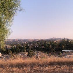
Who knew? After living and working in the Chino Valley, we were not aware that the La Sierra Trail Loop was so close to home. It is a mild 2.5 mile hike providing views of Chino Hills and the Pomona Valley. There is ample parking right outside the entrance and a picnic table is nearby. On the day we visited, we only saw two people taking advantage of this gem. The inclines are not too difficult, and the soil was solid. There are two main loops (La Sierra and Monte Verde) you can choose from, or do them both. The La Sierra Trail Loop is convenient, easy to complete, and not too long. This is a great option for those looking for some great views and for those who wish to avoid cardiac arrest. We cannot wait to return on a sunny day and once the greenery returns! read more


3 years ago
3 years ago
Nice little loop for a casual trail hiking. The one down side is there's like an obstacle course full of poop....Please people pick up after your dogs. read more

6 years ago
5 years ago
I completely forgot about this trail. Which is daily close to my house. Have been coming here for about two months now! Love it so peaceful and it's a good quick 35 min walk. read more

4 years ago
6 years ago
Best time to do this trail is the early morning. The air is so fresh and the scenery is beautiful. I feel safe. read more


This trail is well marked and quiet. Quick 2mi hike. Trails are wide with mixed flat and some inclines (easy-moderate), the gravel helps you get a good step up or down. Nice that it loops so you don't have to backtrack. I went after a week of rain and there were patches of pretty yellow wildflowers in bloom. Can't wait to see what it looks like in the springtime. Watch your step and be careful of coyotes and rattlesnakes. read more


It's not spring yet but the wild flowers are already starting to bloom. The trail head is at the crossroads of Monteverde and La Sierra. You will notice large beautiful new homes in this area. Park on the street. This is a moderate hike with short climbs and descents that make it not boring. I like this hike because you go down into a canyon and cannot see homes. You're just surrounded by nature. There were just one mountain biker and 2 other hikers this weekday morning around 10 am. We spotted a coyote though. Better use hiking shoes because there can be some slippery gravel. Round trip is about 2 miles and took about 1 hour. There is an opportunity to go off to the Monteverde trail which is another 0.8 miles and can add another 45 minutes round trip to rejoin the La Sierra trail. Good for cool weather hikes. There is no shade. read more


11 years ago
Wow!! I am glad this trial is close to where I live, I am going to become a frequent hiker here! It's a good trail to do every weekend, that's for sure! I like that it is not too crowded.. Because of that my doggie can walk off the leash with no problem. This is a great trail for both people and dogs! I know mine had a field day running through the tall grass like her wild ancestors haha.. I honestly worked up a good sweat!! I am going to try and run the whole loop eventually, I am just going to have to build the endurance... Finding the trail was a little tricky... Don't go by the location displayed on yelp, it's is incorrect.... The main cross streets are chino avenue and Peyton... And then the actual cross streets (it's in a residential area) is La Sierra and monte verde... You will be seeing my face here every Sunday and Saturday for quiet some time read more


4 years ago
10 years ago
Good, short 2 mile hike. Follow the signs... Ive tried to go off signs and use other "trails" that i thought would lead me out quicker but found that it got me further away from my car. It is pretty challenging (medium) level. Be careful when bringing your pups as it can be very hot with no-shaded areas and up/down hills can be too much for them if they are overweight or not used to this type of exercise. Make sure you slow down and take lots of rests if it becomes too much for you and your pup. And, bring water for them!! Keep the leash on your dogs as there are a lot of downhill dirt. If your dog is a chaser of bunnies, they can fall in. Also, i have ran into wild life here - a big coyote was watching all of the passerbys while hiding in the bushes. And, today my dogs and i almost step on a snake. read more


Page 1 of 2
More info about La Sierra Trail Loop
Monteverde Dr & La Sierra Dr
Chino Hills, CA 91709
Directions
Hours
Indoor Amenities
Outdoor Amenities
Ask the Community - La Sierra Trail Loop
Review Highlights - La Sierra Trail Loop
You might also consider


Why does Yelp recommend reviews?
La Sierra Trail Loop - hiking - Updated July 2026
Best of Chino Hills
People found La Sierra Trail Loop by searching for…
Hiking Trails in Chino Hills, CA
Places to Take Pictures in Chino Hills, CA
Beautiful Views in Chino Hills, CA
Photo Spots in Chino Hills, CA
Flower Field in Chino Hills, CA
Walking Trails in Chino Hills, CA
Running Trails in Chino Hills, CA
Off Road Trails in Chino Hills, CA
Scenic Drive in Chino Hills, CA
Scenic Night View in Chino Hills, CA
Sunrise View in Chino Hills, CA
Watch Sunset in Chino Hills, CA
Sunset View in Chino Hills, CA
Waterfall Hike in Chino Hills, CA
Dog Friendly Hiking Trails in Chino Hills, CA
Attractions in Chino Hills, CA
Picnic Spots in Chino Hills, CA
Hiking With Kids in Chino Hills, CA
Secret Spots in Chino Hills, CA
Trending Searches in Chino Hills, CA
Black Owned Nail Salons near La Sierra Trail Loop
Boat Rental near La Sierra Trail Loop
Cliff Jumping near La Sierra Trail Loop
Day Trips near La Sierra Trail Loop
Jet Ski Rental near La Sierra Trail Loop
Kayak Rental near La Sierra Trail Loop
Lakes & Ponds near La Sierra Trail Loop
Off Road Trails near La Sierra Trail Loop
Outdoor Activities near La Sierra Trail Loop
Picnic Spots near La Sierra Trail Loop
Places To Swim near La Sierra Trail Loop
Places To Walk Around near La Sierra Trail Loop
Pool Day Pass near La Sierra Trail Loop
Public Pools near La Sierra Trail Loop
Public Shower near La Sierra Trail Loop
River Swimming near La Sierra Trail Loop
River Tubing near La Sierra Trail Loop
Rock Quarry near La Sierra Trail Loop
Running Trails near La Sierra Trail Loop
Scenic Night View near La Sierra Trail Loop
Scenic Overlook near La Sierra Trail Loop
Soccer Store near La Sierra Trail Loop
Splash Pad near La Sierra Trail Loop
Sunrise View near La Sierra Trail Loop
Swimming Holes near La Sierra Trail Loop
Swimming Lakes near La Sierra Trail Loop
Watch Sunset near La Sierra Trail Loop
Browse Articles
Browse Nearby
BEST of Chino Hills, California Coffee near La Sierra Trail Loop
BEST of Chino Hills, California Restaurants near La Sierra Trail Loop
BEST of Chino Hills, California Things to Do near La Sierra Trail Loop
BEST of Chino Hills, California Breakfast near La Sierra Trail Loop
BEST of Chino Hills, California Walking Trails near La Sierra Trail Loop
BEST of Chino Hills, California Parks near La Sierra Trail Loop
BEST of Chino Hills, California Hot Springs near La Sierra Trail Loop
BEST of Chino Hills, California Campgrounds near La Sierra Trail Loop
BEST of Chino Hills, California Sightseeing near La Sierra Trail Loop
Browse Brands
Related Searches in Chino Hills, CA
Affordable Kayak Rental Services in Chino Hills, California
Best Fishing Locations and Guides in Chino Hills, California
Best Nature Trails for Hiking in Chino Hills, California
Best Places for Horseback Riding in Chino Hills, California
Check Out Off Road Trails in Chino Hills, California
Discover Dog Friendly Trails to Explore in Chino Hills, California
Discover Kid Friendly Hiking Trails in Chino Hills, California
Discover Scenic Hiking Trails in Chino Hills, California
Discover Scenic Mountain Bike Trails Near Chino Hills, California
Discover Scenic Waterfall Spots in Chino Hills, California
Discover Top Nature Parks to Visit in Chino Hills, California
Discover Walking Parks in Chino Hills, California Near You
Discover a Hiking Trail in Chino Hills, California
Discover the Best Night Hike Trails in Chino Hills, California
Dog-Friendly Hikes With Dogs in Chino Hills, California
Enjoy Camping Adventures Around Chino Hills, California
Enjoy Exciting Mountain Biking Adventures in Chino Hills, California
Enjoy Kayaking Adventures in Chino Hills, California
Enjoy Tent Camping Spots Around Chino Hills, California
Enjoy a Beautiful Waterfall Hike in Chino Hills, California
Enjoy a Peaceful Nature Walk in Chino Hills, California
Enjoy the Best Walking Path in Chino Hills, California
Enjoy the Best Walking Trails in Chino Hills, California
Exciting Cliff Jumping Spots in Chino Hills, California
Explore Beautiful Parks and Green Spaces in Chino Hills, California
Explore Easy Hikes Perfect for All in Chino Hills, California
Explore Popular Campgrounds Near Chino Hills, California
Explore the Best Beach Spots in Chino Hills, California
Explore the Best Swimming Holes Around Chino Hills, California
Explore the Best Trail Options in Chino Hills, California
Family Friendly Hiking With Kids in Chino Hills, California
Find Beautiful Views in Chino Hills, California
Find the Best Parks for Picnics in Chino Hills, California
Find the Best Scenic View Locations in Chino Hills, California
Great Places to Walk in Chino Hills, California
Hike the Popular Waterfall Trail in Chino Hills, California
Hiking Trails With Waterfalls in Chino Hills, California
Off Leash Dog Hiking Trails in Chino Hills, California
Plan a Scenic Drive Route Near Chino Hills, California
Popular Outdoor Activities to Try in Chino Hills, California
Popular Picnic Spots to Visit in Chino Hills, California
Safe River Swimming Areas in Chino Hills, California
Safe and Fun Parks for Kids in Chino Hills, California
Top Climbing Spots and Gyms in Chino Hills, California
Top Paddleboarding Activities in Chino Hills, California
Top Running Trails to Explore in Chino Hills, California
Top Swimming Lakes to Enjoy in Chino Hills, California
Top Swimming Spots and Pools in Chino Hills, California
Walk Dog Friendly Hiking Trails in Chino Hills, California
Walk the Best Paved Walking Trails in Chino Hills, California