Applewhite Picnic Area Photos


You might also consider
More like Applewhite Picnic Area
Recommended Reviews - Applewhite Picnic Area
Start your review...

Reviews With Photos


This place was awesome a few weeks but it looks like the host is more interested in picking recyclables from the dumpsters then actually running the park, if you're looking for a great out door experience go across the street to the campground. My wife and I just left the picnic area and there were three tents setup next to the water I thought camping in the picnic area was prohibited. Please be considerate and help pick up trash there is a lot more visitors then there is volunteers or forest service workers.

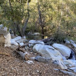
Cute little picnic area nestled back in the hills area of Lytle Creek area. I can sit and watch the creek run for hours. Picnic tables are set up close enough to the water's edge that it makes for a quaint spot to eat and enjoy. Tables are sprinkled around so that there are quite a few yet not too close together, and plenty of shade. Parking is near the tables too, so you don't have to haul your stuff very far. Lots of parking spots up and down the picnic area and each bathroom is within a reasonable walking distance. Very sweet little spot. However, it's not really very clean. Not bad, but seems that the people using the area are inconsiderate. I guess that goes for anywhere in this country of ours, but maybe a ranger or park employee can make an extra sweep of the place to pick up trash. Toilets are pit toilets furnished with toilet paper and and sinks to wash up. There are cute little wood carvings placed around the site and an old shack near the entrance. They've definitely gone the extra distance to make it a cute place for a visit. Relatively close to the city, but far enough away that you feel like you are hundreds of miles up in the mountains. Fresh air, running stream, nature. Not a bad place to visit when you need a nice little get-away. CHEERS!! read more


3 years ago
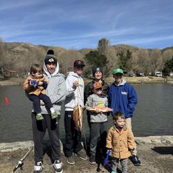
We went with family friends and hung out playing games and having lunch at a table while the kids played in the stream for hours. And when it was time to leave the kids demanded to come back some day. Such a great time. And lots of bathrooms! read more
2 years ago
6 years ago
Had some good family time at this location. Good amount of ice cold water and decent BBQ area with tables. Met alot of friendly people, get there early because yes parking does fill up quick. I don't recommend arriving any later than 8:15am. read more


7 years ago
This place was awesome a few weeks but it looks like the host is more interested in picking recyclables from the dumpsters then actually running the park, if you're looking for a great out door experience go across the street to the campground. My wife and I just left the picnic area and there were three tents setup next to the water I thought camping in the picnic area was prohibited. Please be considerate and help pick up trash there is a lot more visitors then there is volunteers or forest service workers. read more

6 years ago
11 years ago
The water flowing at Apple white picnic area is not from snow run off. Its from the under ground springs about half a mile up stream..there use to be a lot more water. read more


7 years ago
7 years ago
More info about Applewhite Picnic Area
Ask the Community - Applewhite Picnic Area
Does anyone know if barbecuing is allowed at Applewhite picnic area?
Yes there's 1-2 barbecues built in next to every picnic table.
You might also consider


Why does Yelp recommend reviews?
2 reviews that are not currently recommended
The reviews below are not factored into the business's overall star rating.
3 months ago
8 days ago
Applewhite Picnic Area - parks - Updated July 2026
Best of Lytle Creek
People found Applewhite Picnic Area by searching for…
Campgrounds in Lytle Creek, CA
Picnic Areas in Lytle Creek, CA
Things to Do in Lytle Creek, CA
River Swimming in Lytle Creek, CA
Fishing Spots in Lytle Creek, CA
Picnic Spots in Lytle Creek, CA
Parks for Kids in Lytle Creek, CA
Photo Spots in Lytle Creek, CA
Picnic Areas BBQ Pits in Lytle Creek, CA
Gold Panning in Lytle Creek, CA
Camping Sites in Lytle Creek, CA
Scenic Drive in Lytle Creek, CA
National Parks in Lytle Creek, CA
Hiking Trails With Waterfalls in Lytle Creek, CA
Fun Things to Do With Kids in Lytle Creek, CA
Free Snow Play in Lytle Creek, CA
Nature Parks in Lytle Creek, CA
Public Running Track in Lytle Creek, CA
Lakes & Ponds in Lytle Creek, CA
Trending Searches in Lytle Creek, CA
Berry Picking near Applewhite Picnic Area
Blueberry Picking near Applewhite Picnic Area
Cliff Jumping near Applewhite Picnic Area
Day Trips near Applewhite Picnic Area
Free Things To Do With Kids near Applewhite Picnic Area
Fruit Picking near Applewhite Picnic Area
Jet Ski Rental near Applewhite Picnic Area
Kayak Rental near Applewhite Picnic Area
Kids Activities Outdoor near Applewhite Picnic Area
Lakes & Ponds near Applewhite Picnic Area
Outdoor Basketball Courts near Applewhite Picnic Area
Paddle Boat Rentals near Applewhite Picnic Area
Parks For Picnics near Applewhite Picnic Area
Places To Swim near Applewhite Picnic Area
Places To Walk Around near Applewhite Picnic Area
Pokemon Go near Applewhite Picnic Area
Pool Day Pass near Applewhite Picnic Area
Public Swimming Pools near Applewhite Picnic Area
River Swimming near Applewhite Picnic Area
Secluded Spots near Applewhite Picnic Area
Skyline View near Applewhite Picnic Area
Soccer Store near Applewhite Picnic Area
Swimming Holes near Applewhite Picnic Area
Swimming Lakes near Applewhite Picnic Area
U Pick Farms near Applewhite Picnic Area
Browse Articles
Browse Nearby
BEST of Lytle Creek, California Restaurants near Applewhite Picnic Area
BEST of Lytle Creek, California Things to Do near Applewhite Picnic Area
BEST of Lytle Creek, California Coffee near Applewhite Picnic Area
BEST of Lytle Creek, California Picnic Areas near Applewhite Picnic Area
BEST of Lytle Creek, California Gold Panning near Applewhite Picnic Area
BEST of Lytle Creek, California Hiking near Applewhite Picnic Area
BEST of Lytle Creek, California Breakfast near Applewhite Picnic Area
BEST of Lytle Creek, California Natural Hot Springs near Applewhite Picnic Area
BEST of Lytle Creek, California Campgrounds near Applewhite Picnic Area
Browse Brands
Related Searches in Lytle Creek, CA
Best Parks for Parties and Events in Lytle Creek, California
Best Water Parks for Kids in Lytle Creek, California
Check Out Great Playgrounds in Lytle Creek, California
Discover Baseball Fields Around Lytle Creek, California
Discover Fun Toddler Parks in Lytle Creek, California for Your Little One
Discover Lakes & Ponds to Explore in Lytle Creek, California
Discover Popular Bike Trails in Lytle Creek, California
Discover Popular Photo Spots in Lytle Creek, California
Discover Soccer Fields in Lytle Creek, California Near You
Discover Top Nature Parks to Visit in Lytle Creek, California
Discover Walking Parks in Lytle Creek, California Near You
Discover the Best Beaches in Lytle Creek, California
Discover the Best Kids Park Spots in Lytle Creek, California
Enjoy Scenic Places to Walk in Lytle Creek, California
Enjoy the Best Picnic Spots and Ideas in Lytle Creek, California
Enjoy the Best Walking Trails in Lytle Creek, California
Explore Free Picnic Areas Around Lytle Creek, California
Explore Fun Activities to Do in Lytle Creek, California
Explore Parks With Pull Up Bars in Lytle Creek, California
Explore Picnic Parks Near Lytle Creek, California
Explore Popular Campgrounds Near Lytle Creek, California
Explore Popular Kids Parks Throughout Lytle Creek, California
Explore Popular Picnic Areas Around Lytle Creek, California
Explore Popular RV Parks Around Lytle Creek, California
Explore Scenic Lakes to Visit in Lytle Creek, California
Explore Top Dog Parks in Lytle Creek, California Near You
Explore Top Water Parks in Lytle Creek, California Today
Find Great Places to Feed Ducks in Lytle Creek, California
Find Parks and Recreation Activities in Lytle Creek, California
Find Top Dog Friendly Parks to Visit in Lytle Creek, California
Find Top Skate Parks in Lytle Creek, California for All Skill Levels
Find a Kids Birthday Party Park in Lytle Creek, California
Find a Park With BBQ Pits in Lytle Creek, California
Find the Best Parks BBQ Grills in Lytle Creek, California
Find the Best Parks for Picnics in Lytle Creek, California
Find the Best Playgrounds to Visit in Lytle Creek, California
Have Fun at a Splash Pad in Lytle Creek, California
Locate Tennis Courts Around Lytle Creek, California
Picnic Areas With BBQ Pits Available in Lytle Creek, California
Play at a Splash Pad Park in Lytle Creek, California
Popular Picnic Spots to Visit in Lytle Creek, California
Relax in Parks With Shade Areas in Lytle Creek, California
Safe and Fun Parks for Kids in Lytle Creek, California
Top Hiking Trails to Explore in Lytle Creek, California
Top Playgrounds for Kids to Enjoy in Lytle Creek, California
Top Running Trails to Explore in Lytle Creek, California
Top Swimming Lakes to Enjoy in Lytle Creek, California
Top-Rated Camping Sites in Lytle Creek, California
Top-Rated Hikes in Lytle Creek, California to Explore
Visit Top Toddler Playgrounds in Lytle Creek, California for Playtime
People who viewed Applewhite Picnic Area also viewed
Lytle Creek Ranger Station
39 reviews
Lytle Creek - Cajon Pass Recreation Area
3 reviews
Jackson Lake
27 reviews
Green Valley Lake Recreation
39 reviews
Fairmont Regional Park
6 reviews
MacKay Park
42 reviews
San Antonio Falls
66 reviews
North Etiwanda Preserve
307 reviews
Etiwanda Falls Trail
58 reviews
Manker Flats Campground
33 reviews