Kratka Ridge Photos


You might also consider
More like Kratka Ridge
Recommended Reviews - Kratka Ridge
Start your review...

8 years ago
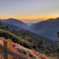
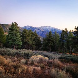
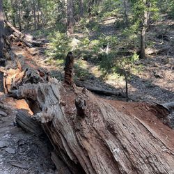
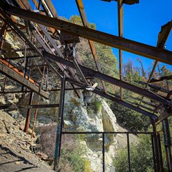
I'm a big fan of abandoned places as I claim to see the beauty in destruction and desolation. Not only are these spots adventurous; but they tell stories in their own defunct ways. My love for deserted spots stems from my childhood growing up in a poverty-stricken ex-steel mill city. Los Angeles isn't necessarily a playground filled with a plethora of abandoned places (as real estate is, although pricey, in demand) but there are some 'cool' places to see. How does an abandoned ski lift sound? Neat? It sure is... So where is this abandoned ski lift, you ask? In the Los Angeles National Forest and it's a bit of a drive to get there. First of all, you generally have to take the 210 to the 2 which is the main freeway going through the heart of the forest. And go through the heart of the forest, it does! This freeway is insanely scary as it is mountain-edging and and has more curves and turns than even the usual LA canyon roads. Not to mention, it is so high up that you get stuck in the marine layer/clouds. I drove at 9am and it was so scary I wanted to cry and there were times I had to drive 20 mph because you truly can't see more than two feet ahead of you. Good luck if your car breaks down. And this isn't just a morning thing... it was like this in the afternoon, as well. Once you get high enough to drive out of the Marine Layer... the views are gorgeous! You won't feel like you are in LA anymore and rather in a state like Colorado or the PNW. High mountain peaks and alpine woods abound: tall pines EVERYWHERE! The air is fresh and crisp and everything seems untouched by the LA smog. It's certainly worth seeing. Campgrounds and picnic areas will start to pop up as the 2 freeway in this area is part of the Pacific Crest Trail (that's right... you will see hikers a la Reese Witherspoon-style in the movie, "Wild". So let's discuss the actual ski lift, shall we? Kratka Ridge ski lift is located past the actual spot where a GPS takes you. Look for the Vista Picnic Area (there is a sign) which is a gravel shoulder parking area. This DOES require Adventure Pass parking (you can get a month pass for $5) but other than that... just pull over. You are immediately at the side of a large hill/mountain and you simply follow the single trail up. The initial trek is moderately difficult as it is steeper than it looks and the altitude gets to you. I workout daily and hike often but it was a workout for my lungs because you are higher than most are used to (you are about 7, 500 feet above sea level!). I even went home with some altitude sickness. But the environment and views are worth it: tall trees and pines, a constant roar of wind (but not too cold surprisingly), large rocks, and unusual plants opening up to stunning, take-your-breath away views of the the National Forest and LA down below. Again... you HAVE to see this! Lots of photo ops! Once at the top of the hike (it's really not that long. About 1.5 miles); you can't miss the abandoned ski lift. The rotting wood structure stands like an imposing fort with the actual lift chairs (single-person chairs) and cables still attached. It's very neat and cool to see but also sort of sad. Everything is clean with no garbage or spray painted vandalism (let's keep it like that, folks) and you can see far away to the Coachella Valley. A picnic table and flat spot (no shade) is also located near the lift. Interestingly, people still actually go up to this spot to ski and the snow in the winter gets deep. Certainly something to check out if into that sort of thing! Despite the crazy 2-freeway drive; Kratka Ridge is worth hiking whether you are into abandoned spots, amazing views that make you feel removed from Los Angeles, or both. You won't regret it! Just get ready for the altitude! read more


5 years ago
Great place to hike and see a deserted ski lift site. I was six years old when I first saw this running. Now I'm 66 years old and have skied the Rockies in Wyoming down to Mammoth, still going strong. I wish my cat Wotan could come along, but he's a stay at home cat. read more

8 years ago
More info about Kratka Ridge
Angeles National Forest California
Pearblossom, CA 93553
Directions
Hours
Outdoor Amenities
You might also consider


Kratka Ridge - hiking - Updated July 2026
Best of Pearblossom
People found Kratka Ridge by searching for…
Abandoned Buildings in Pearblossom, CA
Things to Do in Pearblossom, CA
Hiking Trails in Pearblossom, CA
Picnic Areas in Pearblossom, CA
Tent Camping in Pearblossom, CA
Running Trails in Pearblossom, CA
Shaded Hike in Pearblossom, CA
Off Road Trails in Pearblossom, CA
Things to See in Pearblossom, CA
Lookout Points in Pearblossom, CA
Free Campgrounds in Pearblossom, CA
Canyoneering in Pearblossom, CA
People who viewed Kratka Ridge also viewed
Charlie Turner's Trail
39 reviews
Griffith Park
Mount Hollywood
18 reviews
Griffith Park
Falls Creek Falls
12 reviews
Tameobit Wildlife Sanctuary
1 review
Longview Wildlife Sanctuary
1 review
Blue Ridge Trail
15 reviews
Mount McDill
1 review
Ultimate Destination Trail
5 reviews
Walt Disney's Grave
10 reviews
Glassell Park
Abraham Lincoln Park
31 reviews