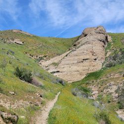
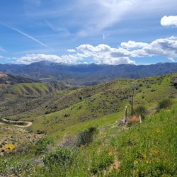
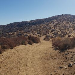
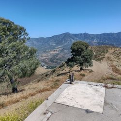
Barrel Springs Trail Photos


You might also consider
More like Barrel Springs Trail
Recommended Reviews - Barrel Springs Trail
Start your review...

Reviews With Photos


This is a GREAT place to bring your horses and ride all the great trails.... You can either stay on relatively flat ground or go up and down various degrees of hills and other terrain. It's impossible to get lost as there are streets on all 4 sides around the park so if you lose your way just ride straight out. There's an arena and a roundpen now and makes it easy to warm your horse up before a ride.


4 months ago
This was my first time coming here, and I really enjoyed it. The trail has two fairly steep hills one going up and one on the way back so it's about a 2-3 mile hike depending on your pace. I'd rate it easy to moderate because of those hills. I brought my 5-year-old, and she was able to handle it, but she did complain on the way back, so next time I probably won't bring her. The views are really nice, and there are a few smaller trails around the area. I'm definitely planning to go again. I went a bit late around 9 a.m., and the sun was already pretty strong, so going earlier would be better. Overall, I 100% recommend this hike. read more


7 months ago
I love hiking so I decided to go to this place and see what happened... My car window was smashed and my backpack with my notebooks were stolen. This happened between 1 and 2 p.m. last Wednesday (10/29/25), in broad daylight. A horrible experience. Be careful and think twice before you park there. There were many cars parked and people was walking around and strangely enough, nobody saw anything. Be mindful before you choose this location. read more

7 months ago
3 years ago
Nice, simple trail to get in a quick workout. You can also stray off the main trail for more of a challenge. Walk it regularly with my dog. read more


4 years ago
We went to watch the sunset. It was fine for that. A lot of scat at the beginning of the trailhead so watch your step! read more

3 years ago
5 years ago
Easy family friendly hike! About 3 miles round trip. Nice dessert views. It was only 70 degrees but the sun felt intense so bring your sunblock and caps. Not much shade along the way to stop and take a break from the sun so I would recommend this as an early morning or late evening hike. read more


13 years ago
This is a GREAT place to bring your horses and ride all the great trails.... You can either stay on relatively flat ground or go up and down various degrees of hills and other terrain. It's impossible to get lost as there are streets on all 4 sides around the park so if you lose your way just ride straight out. There's an arena and a roundpen now and makes it easy to warm your horse up before a ride. read more


11 years ago
This is a really nice spot to walk! The path is clean, very pretty views and there always seems to be someone else walking as well. From start to finish it's about 4.5 miles. The most difficult part is the BIG HILL!!! lol. Take your time and enjoy....it is much easier on the way back. read more


8 years ago
This is a quick go-to. A nice mixture of inclines and declines. A wide trail and fun for all ages. Makes for a nice sunset view while hiking. Mix it up with a trail off the main path. read more


8 years ago
7 years ago
7 years ago
11 years ago
I had a great time walking here todsy there two large hills to walk up and one small .The place is very clean in some parts and other part need to be clean by the city looks like there is a lot of people use ing this park as a dump site. read more


15 years ago
5 years ago
8 years ago
10 years ago
11 years ago
This is a good outdoor hike for an individual or a family. Just use "Caution" if hiking alone. The trail is clean and if you hike at or around 6, you will walk into some incredible sunsets. I have been hiking this trail for several years with my sister. On April 21, 2015, I was bitten by a dog (See photo of the dog and my injuries) The dog was on a leash; however, the owner just got too close to me. I did not peruse any criminal actions against the owner as I really felt that it was just a FREAK accident. ALSO beware that there is a lot of sexual activities going on here; men meeting men for sex. When you drive up, you will see from time to time, especially when it begins to get dark, men waiting in trucks or cars for men to arrive for these sexual acts. If you hike deeper into the hills, which I will NO longer do after my dog attack, you will see couches, condoms, and other sexual contraband lying around. STAY on the trail if you are a female BUT I HIGHLY caution that if you are a female, you do NOT go alone. You just never know when a man will pop out and grab you, or like me, an animal. The trail is approximately 1 1/2 miles one way. There are two steep heels that will get your heart pumping but after you pass these two hills, it is a straight path from then on. I have only encountered one Coyote and I saw him from a distance - so wild animals do exist. Also, there have been rumors loose pit bulls and snakes on this trail...so just keep your eyes open and never think that you are safe. Always hike with caution and never allow your kids to run ahead of you where you can't see with them with your eye. read more

13 years ago
13 years ago
13 years ago
10 years ago
12 years ago
12 years ago
10 years ago
More info about Barrel Springs Trail
25TH St E And Barrel Springs Rd
Palmdale, CA 93550
Directions
Hours
Payment methods
Outdoor Amenities
Ask the Community - Barrel Springs Trail
Review Highlights - Barrel Springs Trail
You might also consider


Why does Yelp recommend reviews?
3 reviews that are not currently recommended
The reviews below are not factored into the business's overall star rating.
6 years ago
5 years ago
13 years ago
Barrel Springs Trail - hiking - Updated May 2026
Best of Palmdale
People found Barrel Springs Trail by searching for…
Beautiful Views in Palmdale, CA
Fun Things to Do With Kids in Palmdale, CA
Off Road Trails in Palmdale, CA
Running Trails in Palmdale, CA
Places to Take Pictures in Palmdale, CA
Walking Trails in Palmdale, CA
Fun Things to Do at Night in Palmdale, CA
Scenic Overlook in Palmdale, CA
Parks for Kids in Palmdale, CA
Dog Friendly Hiking Trails in Palmdale, CA
Fun Places to Go in Palmdale, CA
Trending Searches in Palmdale, CA
Botanical Gardens near Barrel Springs Trail
Bounce House Rentals near Barrel Springs Trail
Campgrounds near Barrel Springs Trail
Cheap Plants near Barrel Springs Trail
Cherry Picking near Barrel Springs Trail
Cliff Jumping near Barrel Springs Trail
Dog Friendly Things To Do near Barrel Springs Trail
Flower Fields near Barrel Springs Trail
Flower Shop near Barrel Springs Trail
Garage Sales near Barrel Springs Trail
Garden Center near Barrel Springs Trail
Lakes & Ponds near Barrel Springs Trail
Nurseries & Gardening near Barrel Springs Trail
Outdoor Activities near Barrel Springs Trail
Outdoor Furniture Stores near Barrel Springs Trail
Parks near Barrel Springs Trail
Party Equipment Rentals near Barrel Springs Trail
Pedicure near Barrel Springs Trail
Photo Spots near Barrel Springs Trail
Picnic Areas near Barrel Springs Trail
Places To Take Pictures near Barrel Springs Trail
Rock Quarry near Barrel Springs Trail
Running Trails near Barrel Springs Trail
Rv Rental near Barrel Springs Trail
Spray Tanning near Barrel Springs Trail
Sunrise View near Barrel Springs Trail
Swimming Holes near Barrel Springs Trail
Table And Chair Rentals near Barrel Springs Trail
Browse Articles
Browse Nearby
BEST of Palmdale, California Restaurants near Barrel Springs Trail
BEST of Palmdale, California Coffee near Barrel Springs Trail
BEST of Palmdale, California Things to Do near Barrel Springs Trail
BEST of Palmdale, California Breakfast near Barrel Springs Trail
BEST of Palmdale, California Shopping near Barrel Springs Trail
BEST of Palmdale, California Thrift Stores near Barrel Springs Trail
BEST of Palmdale, California Hotels near Barrel Springs Trail
Browse Brands
Related Searches in Palmdale, CA
Affordable Horse Boarding Services in Palmdale, California
Affordable Pony Rental Services Available in Palmdale, California
Best Fishing Locations and Guides in Palmdale, California
Best Gymnastics for Kids Activities in Palmdale, California
Best Nature Trails for Hiking in Palmdale, California
Best Places for Horseback Riding in Palmdale, California
Best Waterfalls and Swimming Holes in Palmdale, California
Book Equestrian Lessons With Experts in Palmdale, California
Check Out Off Road Trails in Palmdale, California
Discover Effective Equine Therapy Options in Palmdale, California
Discover Fun Activities to Do in Palmdale, California
Discover Horseback Riding Tours in Palmdale, California
Discover Kid Friendly Hiking Trails in Palmdale, California
Discover Scenic Hiking Trails in Palmdale, California
Discover Scenic Mountain Bike Trails Near Palmdale, California
Discover Scenic Waterfall Spots in Palmdale, California
Discover Walking Parks in Palmdale, California Near You
Discover a Hiking Trail in Palmdale, California
Discover the Best Night Hike Trails in Palmdale, California
Discover the Best Running Track in Palmdale, California
Dog-Friendly Hikes With Dogs in Palmdale, California
Enjoy Camping Adventures Around Palmdale, California
Enjoy Exciting Mountain Biking Adventures in Palmdale, California
Enjoy Hiking Adventures in Palmdale, California
Enjoy Kayaking Adventures in Palmdale, California
Enjoy Stables and Horse Riding Experiences in Palmdale, California
Enjoy Tent Camping Spots Around Palmdale, California
Enjoy Thrilling Atv Riding Experiences in Palmdale, California
Enjoy Water Activities and Fun in Palmdale, California
Enjoy a Beautiful Waterfall Hike in Palmdale, California
Enjoy a Peaceful Nature Walk in Palmdale, California
Enjoy the Best Walking Path in Palmdale, California
Enjoy the Best Walking Trails in Palmdale, California
Exciting Cliff Jumping Spots in Palmdale, California
Experience Exciting Horse Racing in Palmdale, California
Experience Top Dressage Events in Palmdale, California
Explore Beautiful Parks and Green Spaces in Palmdale, California
Explore Bike Rentals Throughout Palmdale, California
Explore Easy Hikes Perfect for All in Palmdale, California
Explore Equestrian Activities and Services in Palmdale, California
Explore Fun Activities to Do in Palmdale, California
Explore Horse Stables and Boarding in Palmdale, California
Explore Horseback Riding Trails in Palmdale, California
Explore Kids Horseback Riding Lessons in Palmdale, California
Explore Popular Campgrounds Near Palmdale, California
Explore Summer Camps for All Ages in Palmdale, California
Explore the Best Rock Climbing Areas in Palmdale, California
Explore the Best Swimming Holes Around Palmdale, California
People who viewed Barrel Springs Trail also viewed
Prime Desert Woodland Preserve
63 reviews
SGT Steve Owen Bench Trail
3 reviews
Devil's Punchbowl Natural Area
137 reviews
Indian Canyon
5 reviews
Islip Saddle
6 reviews
Parker Mountain
3 reviews
Grass Mountain
2 reviews
Dawson Gap to Throop Peak
3 reviews
Martindale Ridge via Rowher OHV
2 reviews
Vasquez Rocks Natural Area Park
318 reviews