Indian Canyon Photos


You might also consider
More like Indian Canyon
Recommended Reviews - Indian Canyon
Start your review...

Reviews With Photos

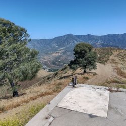
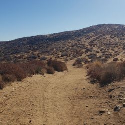
Indian Canyon trailhead provides access to northern and southern sections of the Pacific Crest Trail located in Acton. The southern section of the trail winds its way deep into the Angeles National Forest. The "wild" northern section of the PCT is the more interesting of the two. It takes you on a 10-mile (there and back) hike that passes by some interesting rock formation and Indian caves. It eventually leads to the southern border of Vazquez Rocks located in Agua Dulce. To start, park your car at the Indian Canyon trailhead then you make your way across the street. Head north a short distance until you see signs for the PCT and a KOA camp. The trail initially makes its way through some dense trees and lush vegetation and then crosses some train tracks. From there the trail is pretty well marked. The most strenuous part of the hike is the initial incline up the mountainside. You'll eventually pass by some stone escarpments and an Indian cave as you head north in the direction of Vasquez Rocks. Nearby there do 2 different rock formations that have outcropping resembling a human face (this phenomenon is referred to as mimetoliths). To reach them you'll have to break off the PCT and travel west along Briggs Edison fire Rd. This road can also be accessed from Agua Dulce Canyon Rd although there is a locked gate at the entrance and signs indicating that it is a private residential road.

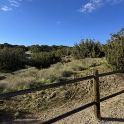
This review is for the Indian Canyon North Via Pacific Crest Trail which was a ~4.5 mile round trip that took ~2 hours to complete. Trail entrance is across the street from the parking lot. The first ~0.5 miles was a bit overgrown and washed out. In addition, there was one large stream crossing with a lot of water. For this particular stream, it was somewhat ankle deep otherwise you can cross by using the logs and trees. Once you cross the railroad tracks to another part of the PCT, it becomes a steady incline / flat trail for the remaining duration of the hike. Plenty of wildflowers and views throughout the hike. Unfortunately, nothing exciting at the end of the trail. Short video of the hike for those interested! https://youtu.be/DyMKtjR5YZk read more


2 years ago
6 years ago
Indian Canyon trailhead provides access to northern and southern sections of the Pacific Crest Trail located in Acton. The southern section of the trail winds its way deep into the Angeles National Forest. The "wild" northern section of the PCT is the more interesting of the two. It takes you on a 10-mile (there and back) hike that passes by some interesting rock formation and Indian caves. It eventually leads to the southern border of Vazquez Rocks located in Agua Dulce. To start, park your car at the Indian Canyon trailhead then you make your way across the street. Head north a short distance until you see signs for the PCT and a KOA camp. The trail initially makes its way through some dense trees and lush vegetation and then crosses some train tracks. From there the trail is pretty well marked. The most strenuous part of the hike is the initial incline up the mountainside. You'll eventually pass by some stone escarpments and an Indian cave as you head north in the direction of Vasquez Rocks. Nearby there do 2 different rock formations that have outcropping resembling a human face (this phenomenon is referred to as mimetoliths). To reach them you'll have to break off the PCT and travel west along Briggs Edison fire Rd. This road can also be accessed from Agua Dulce Canyon Rd although there is a locked gate at the entrance and signs indicating that it is a private residential road. read more


7 years ago
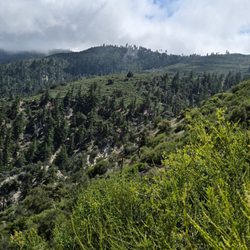
This was my first time hiking on the Pacific Crest Trail in about 25 years. I helped to build the trail 40 years ago in the section from Bouquet Canyon to Liebre Mountain, and I am going to hike from Indian Canyon through the northern extent of the Angeles National Forest in segments. It was a perfect day for this hike when I went at the end of March 2019. There is a good steady climb with little shade, so a day that is not too hot is a good choice. Wildflowers were in abundance, with poppies and other flowers lining the trail in some areas. Beautiful rock formations make this a very special hike. I encountered only about a dozen hikers on the trail, so if you are wanting to get away from the crowds in places like Griffith Park, this is one you might want to check out. If you hike through to Vasquez Rocks, it is about 8 miles. read more


More info about Indian Canyon
7650 Soledad Canyon Rd
Acton, CA 93510
Directions
Hours
Outdoor Amenities
You might also consider


Indian Canyon - hiking - Updated June 2026
Best of Acton
People found Indian Canyon by searching for…
Things to Do in Acton, California
Hiking Trails in Acton, California
Beautiful Views in Acton, California
Off Road Trails in Acton, California
Waterfall Hike in Acton, California
National Parks in Acton, California
View Points in Acton, California
Wildflowers in Acton, California
Running Trails in Acton, California
Walking Trails in Acton, California
Scenic View in Acton, California
Waterfalls in Acton, California
Cave Tour in Acton, California
Tent Camping in Acton, California
Canyoneering in Acton, California
Trending Searches in Acton, CA
Amusement Parks near Indian Canyon
Black Owned Nail Salons near Indian Canyon
Boat Rental near Indian Canyon
Cliff Jumping near Indian Canyon
Dog Friendly Trails near Indian Canyon
Fishing Spots near Indian Canyon
Free Kids Activities near Indian Canyon
Jet Ski Rental near Indian Canyon
Outdoor Activities near Indian Canyon
Pick Your Own Farms near Indian Canyon
Picnic Parks near Indian Canyon
Public Shower near Indian Canyon
Rock Quarry near Indian Canyon
Running Trails near Indian Canyon
Scenic Drive near Indian Canyon
Secluded Spots near Indian Canyon
Soccer Store near Indian Canyon
Strawberry Picking near Indian Canyon
Sunrise View near Indian Canyon
Swimming Holes near Indian Canyon
Swimming Lakes near Indian Canyon
Swimming Pools near Indian Canyon
Watch Sunset near Indian Canyon
Browse Articles
Browse Nearby
Browse Brands
Related Searches in Acton, CA
Best Fishing Locations and Guides in Acton, California
Best Nature Trails for Hiking in Acton, California
Best Places for Horseback Riding in Acton, California
Best Waterfalls and Swimming Holes in Acton, California
Check Out Off Road Trails in Acton, California
Discover Dog Friendly Trails to Explore in Acton, California
Discover Kid Friendly Hiking Trails in Acton, California
Discover Scenic Mountain Bike Trails Near Acton, California
Discover Scenic Waterfall Spots in Acton, California
Discover Walking Parks in Acton, California Near You
Discover a Hiking Trail in Acton, California
Discover the Best Night Hike Trails in Acton, California
Discover the Best Running Track in Acton, California
Dog-Friendly Hikes With Dogs in Acton, California
Enjoy Camping Adventures Around Acton, California
Enjoy Exciting Mountain Biking Adventures in Acton, California
Enjoy Kayaking Adventures in Acton, California
Enjoy Tent Camping Spots Around Acton, California
Enjoy a Beautiful Waterfall Hike in Acton, California
Enjoy the Best Walking Path in Acton, California
Enjoy the Best Walking Trails in Acton, California
Exciting Cliff Jumping Spots in Acton, California
Explore Beautiful Parks and Green Spaces in Acton, California
Explore Easy Hikes Perfect for All in Acton, California
Explore Fun Activities to Do in Acton, California
Explore Popular Campgrounds Near Acton, California
Explore the Best Beach Spots in Acton, California
Explore the Best Swimming Holes Around Acton, California
Explore the Best Trail Options in Acton, California
Family Friendly Hiking With Kids in Acton, California
Find Beautiful Views in Acton, California
Find Parks and Recreation Activities in Acton, California
Find the Best Parks for Picnics in Acton, California
Find the Best Scenic View Locations in Acton, California
Great Places to Walk in Acton, California
Hiking Trails With Waterfalls in Acton, California
Off Leash Dog Hiking Trails in Acton, California
Plan a Scenic Drive Route Near Acton, California
Popular Outdoor Activities to Try in Acton, California
Popular Picnic Spots to Visit in Acton, California
Safe River Swimming Areas in Acton, California
Safe and Fun Parks for Kids in Acton, California
Top Climbing Spots and Gyms in Acton, California
Top Paddleboarding Activities in Acton, California
Top Running Trails to Explore in Acton, California
Top Swimming Lakes to Enjoy in Acton, California
Top Swimming Spots and Pools in Acton, California
Top Things to Do With Kids in Acton, California