Trail Canyon Falls Photos


You might also consider
More like Trail Canyon Falls
Recommended Reviews - Trail Canyon Falls
Start your review...

Reviews With Photos

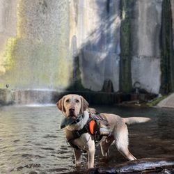
Beautiful trail. Just a heads up to bring proper hiking boots, not just walking shoes with some grip. It won't be enough. There are nine creek crossings, and since the trail is out and back, that means eighteen crossings where you'll be walking through the water. There's really no way to avoid it. The highlight for me was the scenery. The tall mountains are beautiful, and I spotted some birds and butterflies along the way. Many people bring their dogs too, so if your walk is anything like mine, you'll see a few along the trail. I spent about three hours there in total, including time at the waterfall. The waterfall itself was a nice reward at the end. I'm honestly tempted to give it four stars because there are no bathrooms anywhere from the trailhead to the top. But I won't because I'm not docking points off nature for this. Also note, parking isn't in a designated lot. People just park along both sides of the bi directional road near the trail entrance.

What an amazing hike to do, especially when it's been a wet winter! In Mid January 2026 the falls were so full! It was a beautiful site to see! Plus you can aww the falls from the lower section and from the top looking down! To get to the falls it's about a 4.4 mile hike with some incline . We did the falls plus the camp, so we were news up crossing water 18 times so be prepared to get your feet wet now! The water is not terribly cold! To get to the lower falls there is several ropes to climb down so be comfortable with this route before setting off to the falls. This trail is very popular. Especially in the raining season. The official parking lot t the trailhead is super small: holds 4-5 cars. If full you can parallel park on the street but be careful on the highway: fast dangerous traffic zoom by! If your schedule provides, I suggest you hike this trail early in the morning on a weekday. During the summer come prepared for full sun hike most of the way to falls: wear sun screen, bring water and wear a wide brim hat! Happy hiking!


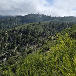
I'd had Trail Canyon Falls on my radar for years and finally made the trek with intrepid hiker and Yelper Cydney M. I didn't know what to expect but given the recent rains we'd had at the time, I knew the waterfall would be at least halfway decent. I did *not* anticpate how challenging the stream crossings would be! Be prepared, especially after the huge storm we just had (February 2023). I bit the bullet and realized a little water wouldn't hurt me. However, watch out for stong currents and potential flash flooding. Check the weather before you go and make sure your cell phone is fully charged. There's no cell phone service but you may still be able to call 911 or text someone if you get stuck. Parking: Find a spot on Big Tujunga Canyon Road, or the tiny parking lot near the trailhead if you're lucky. Depending on the day, you may have to park way up the road, especially on weekends and holidays. Don't forget your Adventure Pass; you are in the Angeles National Forest (not to mention on Native American land). The Trail: The route is stunning. You will be able to see chaparral and riparian forest along the creek as you climb up the ridge iwith tons of native trees and plants. Once you're at the top, you will make a steep descent into the waterfalls with a rope for support. It's not as bad as it sounds, pretty doable actually. It's called Trail Canyon because placer miners had found gold flakes ("trail") in the creek in earlier times. The Waterfall: Described as between 30 and 40 feet tall, it's a stunner. Folks were pretty polite about taking turns to take their selfies; there were a couple of nuts all the way at the top standing reallllllly close to the edge. (I was hoping we wouldn't witness an accidental selfie plunge to the death; be smart, people. Standing on the precipice of a waterfall to get that ultimate selfie is just silly.) Etiquette: Take only pictures and leave only footprints. This trail was remarkably clean and graffiti free. Enjoy!

BEAUTIFUL WATERFALL AND HIKE! ============================= DETAILS: On Saturday, January 7, 2023, my friend Isobel, who I met thanks to Yelp years ago, and I hiked to Trail Canyon Falls. I did not do any research ahead of time and had never been there before. I trusted Isobel to pick the place because she hikes a lot more than I do. This hike and waterfall is definitely on the top of my list of must do hikes, especially in the winter. HIKE: Google Maps will get you to the trailhead. Once you head north on Big Tujunga Canyon Road from Sunland into the Angeles National Forest you'll see cars parked on the side of the road. Stop before you see the intersection of Ottie Road. If you see Rancho Ybarra Campground the Wildwood Picnic Site you have gone too far. The dam is north of the trailhead. After you park and walk toward the fire road the trail is marked well so you won't get lost. However, I am not buying the whole two miles to the waterfall business. It is further than that. I turned on my Apple watch when starting and it was 2.62 miles to the waterfall with an elevation gain of 871 feet. After the rain be prepared to cross the stream about twelve times there and back, so I recommend at least one hiking pole and waterproof hiking shoes because there isn't always enough things to step on to keep your shoes dry. IMPORTANT NOTES: When you get close to the waterfall you will have to climb down a really steep cliff with a rope that was left there for assistance. I wasn't really sure about the strength or quality of the rope, so I wouldn't depend on that completely. TIPS: 1. Bring some snacks and definitely bring water to drink. There are some big rocks and a tree trunk to sit on to take a little break once you get to the waterfall. 2. Try to remove all valuables from your car. I constantly hear about cars being broken into in the Angeles National Forest. Do a sweep of your car before you leave home and just take out the major things including your registration and anything else that can be used to steal your identity. 3. Wear good hiking shoes with decent tread on them. 4. Hiking poles or a ski pole will come in handy for the stream crossings.

Absolutely loved this hike. Went on a Saturday morning started around 6:15am ended 8:45am. It was 40 degrees out so wear layers. First off parking is mostly on the street the lot only holds like 6 cars. I had an adventure pass so I wouldn't get a ticket. The trail has several stream crossings some you can get away with not getting in water on a few some others your gonna get wet. Once you see the falls in the distance go down on your right the first trail that branches off to repel down ropes and rocks to get to the bottom of the falls. About 5 miles round trip. No cell service on trail.

Regardless of the waterfall flow the trail to the fall is enjoyable in itself. Great views from inside the mountain, the trail is an out and back that's just under 5 miles total and it's an easy trail to follow. There are a few parts on the slight climb up when you're nearing the waterfall section that the trail gets a little narrow and you can see over the edge so if heights make you nervous you might want to stay close to the wall. With the main payoff for this hike being the waterfall itself the best time to visit is right after the rainy season. The last couple years in LA we get about 2 weeks in a row of rain and that's about it, the flow is ok around those times an definitely worth a visit since anyone other time of the year you'll most likely see a slight trickle. This trial is pretty popular so arrive early to get a parking spot along the trail side of the road. This hike is in Angeles National Forest, I've heard you don't need to have an adventure pass, but since I have an annual pass I display it just in case.
")
If you speak and sound as soothing as this waterfall, that is the only way you'll get me to sit and listen to you all day :) I hiked here on a recent weekend and it was so dang crowded!!! Multiple groups of people, about 10 persons deep and their dog, hiking out here. At least, the likelihood of getting lost is close to none. As there will be so many nice hikers around for you to ask for directions, if needed. Couple shallow water crossings and dirt trail gets a bit narrow in some areas. Small section where you'll be scrambling, with a rope to hang on to (if needed) when and if you decided hike to the bottom of the falls as I did. There is a trail leading to the top of the falls too. Otherwise, about 1,000 feet elevation gain and 4.8 miles out and back. Very limited parking at the trailhead. Most cars are parked along the main road. I had my Adventure Parking Pass on my dashboard, in case. Bring your "ten essentials" (REI has a good list to refer to, if you aren't sure what I'm talking about). Zone out the chatter of all the people, this waterfall was relaxing and worth adventuring to. Hope you all stay safe and healthy (mind, body and soul) out there :)

A very enjoyable, fairly easy, moderate rated hike. The rope climbing to the lower falls at the end is over dramatized by some reviews. It's really not difficult for the average fitness level; I even climbed down most of it without the help of the ropes. It's worth going down though because the waterfall is beautiful and at the top you can't see anything anyway so we skipped that part. Parking is limited right next to the trailhead, which is right off the main road, but we saw many other cars parked along the road past the trailhead so parking enforcement seems to be lax here thankfully. The first bit of the hike takes you up and over and then down a small hill, into the canyon along the stream, which is very shallow only an inch or two deep, and then to the hardest part of the hike which is the last 1.5 mile climb up to where the falls are. It is a well defined path, it's just all uphill during this portion. The falls themselves are worth it; truly serene and they were extra strong flow wise. Took us 2 hours total and our feet did not get wet a single time. Highly recommend and I plan to return.

During the Covid-19 pandemic, I picked up hiking. This is one of the trails I have been to. I arrived early (7:30am) thinking I am beating the crowd. Little did I know, hikers started much much earlier. As I started my hike, hikers are coming down the trail. Most of the trail is going up and steep.You'll pass small streams and wooded area. Beautiful view of the canyon that you can't miss. And then the waterfalls that makes the hike worthwhile. It is hard to believe that such beautiful creation is up the mountain. Make sure to bring enough water. Watch out for snakes. Small parking on the side of the road.

One of the greatest trails I've been on which is saying something because I've been on quite a few. It's a pretty extensive trail. There's lots of changes of scenery at different stages of the hike so that really brightens up the hike and makes it more exciting. There's a waterfall near the ends of the hike with extremely cold water. FYI your allowed to take a dip in it for anyone that was wondering. There's also a specific section of the hike where you have to use ropes provided to climb down the mountain in order to get to the waterfall. Throughout the hike you will encounter many small streams or creaks that you'll have to step over and in some instances if you mess up your footing expect to get a little wet. The views on the hike is quite breathtaking. This is a fairly simple hike, 100% beginner friendly, definitely recommend everyone to give it a shot.


28 days ago


This hike was interesting, but for me it was definitely more difficult and a lot more dangerous than I expected. The first part of the trail, down to the creek and along the creek, was not too hard and actually pretty enjoyable. Crossing the creek several times was fun, and there were some nice shaded areas along the way. We also saw a California newt, which was really interesting -- but please do not touch them. Later, when we finally had internet again, we read that their skin produces a toxin, so it's best to admire them from a safe distance. The harder part starts after you climb above the creek. From there, the trail leading toward the waterfall becomes narrow and slippery, and on the right side there are steep drop-offs almost the entire way. The final descent to the waterfall was the biggest challenge for me. You have to go down along the rock with a rope for support, but honestly it did not look safe at all, so we decided not to go all the way down to the base of the waterfall. I would not bring children on this hike. Also, be prepared that the round trip can take around 3.5 hours depending on your pace. A few helpful things to know: * parking was along the road * there are no restrooms * tickets/permits need to be purchased in advance in a different place * internet service was very poor, so it's better to download your map ahead of time * there were not many people, which was nice The waterfall was full and rushing, and the views were beautiful, but personally I would not do this hike a second time. read more


4 months ago
Beautiful trail. Just a heads up to bring proper hiking boots, not just walking shoes with some grip. It won't be enough. There are nine creek crossings, and since the trail is out and back, that means eighteen crossings where you'll be walking through the water. There's really no way to avoid it. The highlight for me was the scenery. The tall mountains are beautiful, and I spotted some birds and butterflies along the way. Many people bring their dogs too, so if your walk is anything like mine, you'll see a few along the trail. I spent about three hours there in total, including time at the waterfall. The waterfall itself was a nice reward at the end. I'm honestly tempted to give it four stars because there are no bathrooms anywhere from the trailhead to the top. But I won't because I'm not docking points off nature for this. Also note, parking isn't in a designated lot. People just park along both sides of the bi directional road near the trail entrance. read more


What an amazing hike to do, especially when it's been a wet winter! In Mid January 2026 the falls were so full! It was a beautiful site to see! Plus you can aww the falls from the lower section and from the top looking down! To get to the falls it's about a 4.4 mile hike with some incline . We did the falls plus the camp, so we were news up crossing water 18 times so be prepared to get your feet wet now! The water is not terribly cold! To get to the lower falls there is several ropes to climb down so be comfortable with this route before setting off to the falls. This trail is very popular. Especially in the raining season. The official parking lot t the trailhead is super small: holds 4-5 cars. If full you can parallel park on the street but be careful on the highway: fast dangerous traffic zoom by! If your schedule provides, I suggest you hike this trail early in the morning on a weekday. During the summer come prepared for full sun hike most of the way to falls: wear sun screen, bring water and wear a wide brim hat! Happy hiking! read more


12 days ago
21 days ago
4 months ago
Moderate trail, awesome waterfall! This place is beginner to moderate level hikers. I've seen kids around 7-11 years old on this trail. One of my favorite local trails near San Fernando Valley. read more


22 days ago
5 months ago
8 months ago
I'd had Trail Canyon Falls on my radar for years and finally made the trek with intrepid hiker and Yelper Cydney M. I didn't know what to expect but given the recent rains we'd had at the time, I knew the waterfall would be at least halfway decent. I did *not* anticpate how challenging the stream crossings would be! Be prepared, especially after the huge storm we just had (February 2023). I bit the bullet and realized a little water wouldn't hurt me. However, watch out for stong currents and potential flash flooding. Check the weather before you go and make sure your cell phone is fully charged. There's no cell phone service but you may still be able to call 911 or text someone if you get stuck. Parking: Find a spot on Big Tujunga Canyon Road, or the tiny parking lot near the trailhead if you're lucky. Depending on the day, you may have to park way up the road, especially on weekends and holidays. Don't forget your Adventure Pass; you are in the Angeles National Forest (not to mention on Native American land). The Trail: The route is stunning. You will be able to see chaparral and riparian forest along the creek as you climb up the ridge iwith tons of native trees and plants. Once you're at the top, you will make a steep descent into the waterfalls with a rope for support. It's not as bad as it sounds, pretty doable actually. It's called Trail Canyon because placer miners had found gold flakes ("trail") in the creek in earlier times. The Waterfall: Described as between 30 and 40 feet tall, it's a stunner. Folks were pretty polite about taking turns to take their selfies; there were a couple of nuts all the way at the top standing reallllllly close to the edge. (I was hoping we wouldn't witness an accidental selfie plunge to the death; be smart, people. Standing on the precipice of a waterfall to get that ultimate selfie is just silly.) Etiquette: Take only pictures and leave only footprints. This trail was remarkably clean and graffiti free. Enjoy! read more


 - Hiking Near Me - Tujunga, California")
BEAUTIFUL WATERFALL AND HIKE! ============================= DETAILS: On Saturday, January 7, 2023, my friend Isobel, who I met thanks to Yelp years ago, and I hiked to Trail Canyon Falls. I did not do any research ahead of time and had never been there before. I trusted Isobel to pick the place because she hikes a lot more than I do. This hike and waterfall is definitely on the top of my list of must do hikes, especially in the winter. HIKE: Google Maps will get you to the trailhead. Once you head north on Big Tujunga Canyon Road from Sunland into the Angeles National Forest you'll see cars parked on the side of the road. Stop before you see the intersection of Ottie Road. If you see Rancho Ybarra Campground the Wildwood Picnic Site you have gone too far. The dam is north of the trailhead. After you park and walk toward the fire road the trail is marked well so you won't get lost. However, I am not buying the whole two miles to the waterfall business. It is further than that. I turned on my Apple watch when starting and it was 2.62 miles to the waterfall with an elevation gain of 871 feet. After the rain be prepared to cross the stream about twelve times there and back, so I recommend at least one hiking pole and waterproof hiking shoes because there isn't always enough things to step on to keep your shoes dry. IMPORTANT NOTES: When you get close to the waterfall you will have to climb down a really steep cliff with a rope that was left there for assistance. I wasn't really sure about the strength or quality of the rope, so I wouldn't depend on that completely. TIPS: 1. Bring some snacks and definitely bring water to drink. There are some big rocks and a tree trunk to sit on to take a little break once you get to the waterfall. 2. Try to remove all valuables from your car. I constantly hear about cars being broken into in the Angeles National Forest. Do a sweep of your car before you leave home and just take out the major things including your registration and anything else that can be used to steal your identity. 3. Wear good hiking shoes with decent tread on them. 4. Hiking poles or a ski pole will come in handy for the stream crossings. read more


2 years ago
Absolutely loved this hike. Went on a Saturday morning started around 6:15am ended 8:45am. It was 40 degrees out so wear layers. First off parking is mostly on the street the lot only holds like 6 cars. I had an adventure pass so I wouldn't get a ticket. The trail has several stream crossings some you can get away with not getting in water on a few some others your gonna get wet. Once you see the falls in the distance go down on your right the first trail that branches off to repel down ropes and rocks to get to the bottom of the falls. About 5 miles round trip. No cell service on trail. read more


Regardless of the waterfall flow the trail to the fall is enjoyable in itself. Great views from inside the mountain, the trail is an out and back that's just under 5 miles total and it's an easy trail to follow. There are a few parts on the slight climb up when you're nearing the waterfall section that the trail gets a little narrow and you can see over the edge so if heights make you nervous you might want to stay close to the wall. With the main payoff for this hike being the waterfall itself the best time to visit is right after the rainy season. The last couple years in LA we get about 2 weeks in a row of rain and that's about it, the flow is ok around those times an definitely worth a visit since anyone other time of the year you'll most likely see a slight trickle. This trial is pretty popular so arrive early to get a parking spot along the trail side of the road. This hike is in Angeles National Forest, I've heard you don't need to have an adventure pass, but since I have an annual pass I display it just in case. read more


If you speak and sound as soothing as this waterfall, that is the only way you'll get me to sit and listen to you all day :) I hiked here on a recent weekend and it was so dang crowded!!! Multiple groups of people, about 10 persons deep and their dog, hiking out here. At least, the likelihood of getting lost is close to none. As there will be so many nice hikers around for you to ask for directions, if needed. Couple shallow water crossings and dirt trail gets a bit narrow in some areas. Small section where you'll be scrambling, with a rope to hang on to (if needed) when and if you decided hike to the bottom of the falls as I did. There is a trail leading to the top of the falls too. Otherwise, about 1,000 feet elevation gain and 4.8 miles out and back. Very limited parking at the trailhead. Most cars are parked along the main road. I had my Adventure Parking Pass on my dashboard, in case. Bring your "ten essentials" (REI has a good list to refer to, if you aren't sure what I'm talking about). Zone out the chatter of all the people, this waterfall was relaxing and worth adventuring to. Hope you all stay safe and healthy (mind, body and soul) out there :) read more
 - Hiking Near Me - Tujunga, California")
A very enjoyable, fairly easy, moderate rated hike. The rope climbing to the lower falls at the end is over dramatized by some reviews. It's really not difficult for the average fitness level; I even climbed down most of it without the help of the ropes. It's worth going down though because the waterfall is beautiful and at the top you can't see anything anyway so we skipped that part. Parking is limited right next to the trailhead, which is right off the main road, but we saw many other cars parked along the road past the trailhead so parking enforcement seems to be lax here thankfully. The first bit of the hike takes you up and over and then down a small hill, into the canyon along the stream, which is very shallow only an inch or two deep, and then to the hardest part of the hike which is the last 1.5 mile climb up to where the falls are. It is a well defined path, it's just all uphill during this portion. The falls themselves are worth it; truly serene and they were extra strong flow wise. Took us 2 hours total and our feet did not get wet a single time. Highly recommend and I plan to return. read more


During the Covid-19 pandemic, I picked up hiking. This is one of the trails I have been to. I arrived early (7:30am) thinking I am beating the crowd. Little did I know, hikers started much much earlier. As I started my hike, hikers are coming down the trail. Most of the trail is going up and steep.You'll pass small streams and wooded area. Beautiful view of the canyon that you can't miss. And then the waterfalls that makes the hike worthwhile. It is hard to believe that such beautiful creation is up the mountain. Make sure to bring enough water. Watch out for snakes. Small parking on the side of the road. read more


3 years ago
3 years ago
One of the greatest trails I've been on which is saying something because I've been on quite a few. It's a pretty extensive trail. There's lots of changes of scenery at different stages of the hike so that really brightens up the hike and makes it more exciting. There's a waterfall near the ends of the hike with extremely cold water. FYI your allowed to take a dip in it for anyone that was wondering. There's also a specific section of the hike where you have to use ropes provided to climb down the mountain in order to get to the waterfall. Throughout the hike you will encounter many small streams or creaks that you'll have to step over and in some instances if you mess up your footing expect to get a little wet. The views on the hike is quite breathtaking. This is a fairly simple hike, 100% beginner friendly, definitely recommend everyone to give it a shot. read more


3 years ago
This place is absolutely stunning!! There was so much water it was a fun and not to hard of a hiki lots of people The air was amazing I definitely want to go back again. Take your family and kids read more


4 years ago
Amazing hike. Pretty easy hike if you regularly hike up until the last bit of it with the ropes. I wouldn't say the last part to get down to the waterfall was particularly difficult but if you are older, uncoordinated, or a bit anxious about slipping then maybe be be aware of this. However, I wouldn't say don't go on this hike. It still is great! Just know you won't see the water fall looking up but can still see the top of it if you don't go down. PARKING: no lot but parking on the side of the rode is totally good/safe (don't come at me if your car gets broken into tho!) When I got there (kinda early) there were no cars but don't worry cars will show up later. Just stay in the white line. REMEMBER: don't be a litter bug and stay safe read more


3 years ago
Great 5mi hike/workout! Make sure to come in early because it gets too hot in the middle of the day and a good portion of the trail has limited to zero shade. Getting to the falls is a little tricky, you can miss the inconspicuous down trail easily - as soon as the top of the falls becomes visible from where you are, keep on a lookout for a steep off-path trail to your right. Be careful on your way down as it is pretty steep but still manageable. There will be a couple of ropes on the steepest part of the descend that can help you navigate the path until you get to the bottom, which is also bottom of the falls! Def worth it! read more


I mean just look at the views. Easily one of the best hikes I've been on in SoCal. Its so calm and peaceful, but also doable for all hiking levels. The colors are breathtaking, the silent is tranquil, and overall the hike brings peace and serenity. I did this hike during one of my rare off days in the late summer and it was just what I needed to relax after a long week. My one regret is not catching the waterfall at it's peak. Trust me though, I plan to fix that in the spring. One thing I will say is, like many LA hikes, there isn't much shade throughout the hike. So I would strongly recommend bringing loads of sunscreen and a good bucket hat. read more


We did this on Saturday (2/16/19) after receiving several recent storms so the fall was flowing extremely well. Because of all the recent precipitation the creek crossing were somewhat difficult though. Location: in Sunland-Tujunga off the 210 just west of where the 2 connects; parking is on Big Tujunga Rd...about half a mile after you cross a bridge...there will be a small dirt road to the left with a metal barrier and we found some parking along the dirt before the barrier Trail- for about .75 you are on an access road that leads to the trailhead which is near some cabins...stay to the left and you will see the official start of the trail and a sign nearby saying it is not a maintained trail but we found it to be in good condition; we had to cross the water about 5 or 6 times each way and there were times that the water was up to our knees and moving swiftly in parts; we visited a couple years ago and turned back after a few crossings and I'm glad we didn't do that this time; none of the trail is very steep with about 300 ft of elevation gain every mile...there is a steep part going down to the base of the falls but there were two ropes and you will be fine if you take your time Fall- it was flowing so nice and it was a great experience to see it flowing so nicely and there are times throughout the year that it is not flowing at all which makes the hike easier but I am sure less enjoyable read more


5 years ago
This is a fun trek to the waterfall, which is just under 5 miles out and back. There are moderate hills and elevation of about 1,000 ft gain overall. The trail is single track and fire road. Most of the trail is exposed but there are pleasant, wooded areas which include shallow stream crossings. Just before you reach the waterfall, there is a rope that can be used for keeping your footing while descending or ascending the steep but short segment. parking - free in the small lot or road side read more

7 years ago
This hike was really fun! We arrived around 8:30pm and parked along the highway since it was already starting to get filled up. It takes a couple of minutes to reach the trailhead from the parking area, you'll see a couple cabins inside, which indicates the trail is beginning once you pass them. We had a number of rain storms recently, so the forest was very green and had a good amount of water flowing throughout the stream. The hike took around 3 hours round trip and had plenty of exciting elements to it, such as balancing on logs for stream crossings and using ropes to get down to the waterfall area. There is a good amount of shade during the first section of the hike, but the sun is shining down around the final part of the hike. The weather was great during the time of our hike, it was warm and not too hot. At the end of the trail is a waterfall, which is pretty spectacular for LA standards. You can hike to the point above the waterfall as well as down to the waterfall floor. You'll definitely need hiking shoes with good traction for this hike, I wore regular running shoes and slipped a couple of times. Bring those hiking shoes to be safe! Waterproof socks and/or shoes are also a good idea to stay dry. This is a moderate level hike, but I did see some young Boy Scouts along the trail, so it shouldn't be too difficult for all levels. Overall, it was a fun hike and I definitely wouldn't mind coming back again. It wasn't too difficult or easy, so it's perfect if you want a bit of a challenge. read more


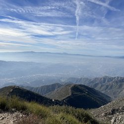
During the COVID era, I have been looking for activities to do that both get me out of the house and keep me safe from COVID exposure. Part of that is (finally) going out to the San Gabriel Mountains and looking for nice hikes. And I found one! Parking was not that difficult, I made sure to display my adventure pass (they will ticket you if you're not displaying yours) and started hiking. The hike meanders by a couple of residents and then the real nature parts begins. There are a few creek crossings so I'd be concerned about this hike after a really heavy rain. There is also some shade too. The picnic table is about the halfway point. After that, there's a small steep section but the views of the canyon and Mt. Lukens are wonderful. Then once you turn around the bend, you'll see the waterfall. I will warn you that there's a very steep final climb to the waterfall. It's a ramble and you'll have to use the rope there to help you climb. But once you make it, it's a great spot and you'll have earned it. I imagine this is a good hike to take good friends who are not big hikers on. I have in the past made the mistake of picking hikes that are too steep or too long. This one is both a good length, not too steep (except for the end point) and the waterfall at the end is a nice touch and a great place to take photos/eat lunch. But if you're deciding which hike to take your friends on, pick this one. read more


So, we wanted to go hiking with our friends. Happened to see these falls on a video on youtube by Josh from californiathroughmylensdotcom. So I told my wife about it and she said it looked good. You do need an Adventure Pass to park in Angeles Crest Forest, we didn't know this was part of the forest and went back down to 7-11 and got one. The trail head isn't well marked as someone else mentioned, but there were a lot of cars parked there so we figured it out. Well this was the perfect day and the perfect time of year. It was nice and cool plenty of water. There are plenty of stream crossing, but none of them that bad, I never fell in, though our friend did once. There are some spots that are kind of narrow as you hike up along the mountain, but they are fine, my daughter never complained. When you get to the fall you can climb down to the pool at bottom, very nice, recommend you do it. Even though it is a little tricky which is why someone left a rope which makes it doable. and even though another hiker had recommended us to go past the falls. What a treat, there is a Cherry Blossom tree and it was in bloom. read more


Love it from start to finish. It can be very difficult to find this trail to begin with. This website link sent us to the correct location: https://modernhiker.com/hike/trail-canyon-falls/ The trail first takes you through a small residential area. Please be mindful and respectful. Do not forget to sign the register at the beginning of the trail as well. Quickly after you commence you will start to see a stream of water that you will follow and stream cross at least 4-5 times throughout the hike. The hike itself is not extremely strenuous. This is an excellent choice for a beginner hiker with a couple of small hikes under their belt. Some might even consider this trail slightly moderate. There is some shade at the beginning but once you leave the stream behind and start to descend all tree shade is lost. That is why this hike is best to do early morning. In order to get to the waterfall you will have to do some rope climbing down or very careful hiking down a steep path. It is not to long but just be careful and take your time. The waterfall is quite beautiful after some rain or during the spring. I used this trail as part of my training for our backpacking trip. Once I carried my osprey backpacker bag and it was a great trail to train in. Mileage 4-4.5 miles roundtrip. PLEASE ALWAYS BE PREPARED WITH PLENTY OF WATER, FIRST AID KIT, WARM CLOTHING, FOOD, SNACKS. It is better to be safe than sorry. ALWAYS! A must hike to do ! read more


6 years ago
This trail is close to Sunland-Tujunga area. There is a small dirt parking area in front of the closed gate on Trail Canyon Road. Don't park and block the gate. There is plenty of parking space on Big Tujunga Canyon Road area. I displayed my adventure pass just in case even though many suggested it's not needed. I read prior reviews and there has been break-ins while hiking. So please hide all your valuables. This is about a 4 mile round trip hike. There is not restrooms in this area. Walk past the gate and follow the road. There is a fork in the road, go right, but there are posted signs to direct you to the trail head. You will pass thru some homes in this area so be respectful and don't talk loud as people could be sleeping in the early morning. Once you pass the homes, it will start to become a real hiking trail. It's only one trail in, and you will cross a few streams. Depending on rainfall, the water level will vary. As you near the waterfall, you will be able to see it from a distance. From there keep an eye out for a small side trail going down into the canyon. There will be ropes to help you climb down the steep portion. If you make it to the top of the waterfall. Then you missed it. Just back track and look for the small turnoff. But at the top of the waterfall there are ropes also where you can climb down and have a top view which is nice. But assuming the water level is safe, as this can be potentially dangerous. Overall, this hike is nice. But looking to be more like Eaton Canyon Falls. There were quite amount of litter and graffiti's on the rock. But it's still better than Eaton Canyon Falls for now. As always pack accordingly to the weather and have fun. read more


I'm surprised there's only about 82+ reviews of this place, which makes me believe that this trail is very underrated or not yet known to the public. This is only 25 minutes from where I live and likely my favorite hike around the area! This trail is part of the Angeles National Forest. I highly recommend coming early to avoid large crowds. It takes about at least a good hour and 15 minutes one way. Not much rain so far this year so it might be best to check it out soon. It has everything you are looking for in a hike. For example, there were at least 4 creeks we had to cross, large rocks, overall not too steep (just getting down and up from the waterfall), and a very nice waterfall at the end of the hike! If you are a hiker, please get some hiking shoes, a pair with a nice grip. Bring water and light snacks. Lastly, start your hike early. My boyfriend and I started the hike at 7:15am and finished by 9:30am given that we took a good 10-15 minutes for photos and breaks throughout the hike. With that said, I highly recommend Trail Canyon Falls! read more


3 years ago
4 years ago
This little hike was perfect and had a great prize waterfall at the end! I went on a weekday, so it wasn't crowded at all. I brought Seanwiches with me and had a nice little sandwich lunch listening to the water crashing down from the falls. Highly recommend it! read more

It was an amazing hike with amazing views! We parked on the side of the road and walked up to the trail entrance. No adventure pass was needed (albeit don't leave valuables in the car, you'll be gone for a good while). We came right after the rain (rained most of the week Feb. 11th-15th, came Saturday, Feb. 16th 2019) and because of the rain it was probably why it was the hardest hike I've done so far to get to a waterfall destination. The river currents were ROARING. Boyfriend and I struggled a lot going to the falls because this was our first time here and we were unsure of the river depths (deepest was waist deep) and overall strength of the currents were intense. 5 miles(ish RT) (honestly felt like more because of the incline), multiple river crossings and some rock climbing later, we succeeded and it was SO worth the journey. Took us 3.5 hours to finish with the added time of hanging out by the waterfall. We started the hike at 9:00AM and luckily very few people when we arrived at our destination, we even managed a good solid 15 minutes of the falls to ourselves (total was only about 5 of us, still better than the 30+ people at Eaton Falls LOL). I definitely recommend hiking this with a partner if you choose to come right after a downpour and/or is short. During the summer when it's more dry, solo hiking this trail is fine. We were very lucky that there were 3 other hikers that we met along the way that we were all able to help each other safely cross the rivers (I'm on the short side so some of the river waters were far higher for me than for the taller hikers). 2 liters of water for two people during the moist and wet season is more than enough. We brought 4 liters and only finished 1.5 liters, but 2 liters per person during the summer since the last quarter of the trail has ZERO shade and gets REAL sunny/hot I'd imagine. We've hiked river trails before so we always bring extra set of clothes/shoes, definitely bring some with you! You'll be soaked (pants, shoes, socks and possibly underwear too) when you're done. Have fun! :) read more


Greetings, Another trail marked off the ol' "Apocalyptic Hike" list! Let's start off with the basics, a majority of the parking is on the side of the road. So make sure that insurance is paid up, because losing a mirror or the back end of your car just might be the case (okay, that's a bit dramatic, but it's definitely a tight fit). As always, wear sunscreen, a hat, bring plenty of water, and definitely invest in waterproof shoes/boots/ or put plastic bags over those kicks when crossing the little creeks that wind though the trail (you know you have plenty of Target bags stuffed somewhere LOL!). Be prepared for a steady and fairly steep include. I would rank it as a moderate hike for incline and distance, but definitely is not a hike for those afraid of heights. There are parts of the upper half of the trail that are very narrow and have beautiful but her sheer drop offs on one side. This trail is heavily utilized and definitely has its challenges when in the narrow sections and how you navigate the other hikers. I tend to allow those that are coming up the trail, uphill hiker, to have the right away and find a safe spot to distance myself. This is just a rule of thumb that I follow and trust me you will have plenty of practice on this trail to get it right And by the way, do not use bags on your feet! This is a joke people! As always I hope this review helps and enjoy the hike! read more


5 years ago
Awesome beautiful hike! I enjoyed this trail very much. It's only a 4.8 mile hike. The views of this place are amazing. It was fun crossing the river, walking on the edge of the mountains, rock climbing to the top of the waterfall, and finally rope climbing down the bottom of the waterfall. If you are planning to rope climb, I would suggest to wear gloves. It's very helpful. Before you go to the top of the waterfall, there's a trail that heads right downward, that's where you rope climb down to visit the bottom of the waterfall. I would rate this hike moderate. Fun for the family and friends. read more


Page 1 of 4
More info about Trail Canyon Falls
Trail Canyon Rd
Tujunga, CA 91042
Directions
Hours
Outdoor Amenities
Ask the Community - Trail Canyon Falls
Are reservations needed for this hike? If so where do I get them?
No reservations are needed.
Is it open today July 11 2020?
Yes, it's not closed. But I think the waterfall is drying up, so hurry up😊
Does this hike need an adventure pass?
No adventure pass needed. But you do need to park outside the restricted area which has signs clearly displayed... across the street is mostly okay except for that section. Arriving early to get a spot is best, per usual.
Where can I buy an adventure pass and is it really necessary to buy one?
No, you do not need an adventure pass for this hike. The USDA Forest Service has designated this hike as a "non-fee" area. If you ever do need an adventure pass, you can pick them up at most sporting goods stores (REI, Big 5, etc., and many other… Read more
Review Highlights - Trail Canyon Falls
You might also consider


Why does Yelp recommend reviews?
2 reviews that are not currently recommended
The reviews below are not factored into the business's overall star rating.
5 years ago
12 years ago
Trail Canyon Falls - hiking - Updated June 2026
Best of Tujunga
People found Trail Canyon Falls by searching for…
River Swimming in Tujunga, California
Hiking Trails With Waterfalls in Tujunga, California
Things to Do in Tujunga, California
Campgrounds in Tujunga, California
Hot Springs in Tujunga, California
Free Snow Play in Tujunga, California
Rock Climbing in Tujunga, California
Shaded Hike in Tujunga, California
Camping Sites in Tujunga, California
Lookout Points in Tujunga, California
Secret Spots in Tujunga, California
Easy Hikes in Tujunga, California
Running Trails in Tujunga, California
Off Road Trails in Tujunga, California
Waterfall in Tujunga, California
Picnic Areas in Tujunga, California
Camping Cabins in Tujunga, California
Scenic Drive in Tujunga, California
Hiking Trails Kid Friendly in Tujunga, California
Browse Nearby
BEST of Tujunga, California Coffee near Trail Canyon Falls
BEST of Tujunga, California Restaurants near Trail Canyon Falls
BEST of Tujunga, California Things to Do near Trail Canyon Falls
BEST of Tujunga, California Lakes near Trail Canyon Falls
BEST of Tujunga, California Parks near Trail Canyon Falls
BEST of Tujunga, California Breakfast near Trail Canyon Falls
BEST of Tujunga, California Hot Springs near Trail Canyon Falls
BEST of Tujunga, California Campgrounds near Trail Canyon Falls
Browse Brands
Browse Articles
People who viewed Trail Canyon Falls also viewed
Switzer Falls - USDA Forest Service
293 reviews
Cooper Canyon Falls
24 reviews
Big Tujunga Canyon
5 reviews
Sunland
Falls Creek Falls
12 reviews
Sturtevant Falls
720 reviews
Eaton Canyon Falls Trail
13 reviews
Wilson Canyon Park
25 reviews
Sylmar
Devil's Canyon Trail
14 reviews
Strawberry Peak
20 reviews
Colby Canyon Trail
3 reviews