Mount Lukens Photos


You might also consider
More like Mount Lukens
Recommended Reviews - Mount Lukens
Start your review...

Reviews With Photos

This hike actually have quite a few routes you can take to get to Mount Lukens. So you can change it up a bit and knock these out if you live close by or just want say you did them all. We started from Deukmejian Wilderness Park. The parking area is free, so that's a plus. The park itself is well maintained, and the restrooms here are pretty good. This is a tough 10 mile RT, that starts on the Crescenta View Trail and loops back down with very little shade from the sun. So plan accordingly if you're hiking this during the summer. I suggest printing out a map as you don't want to get lost in this long 10 mile loop, we used the hikingguy website, as he actually wrote a great turn by turn detail to summit Mount Lukens and has a trail map of the area. Other than that, the hike was fun, the views were great going up and at the radio towers. We didn't see a lot of hikers, so that was refreshing. There could be more trails, but here are the other alternative routes if you want to try out. Via Stone Canyon - 9 mile RT Via Haines Canyon - 8.5 mile RT As always, pack accordingly to the weather and have fun.

There are multiple ways you chose to take to get to the peak. We began our 10.8 mile journey at Deukmejian Wilderness Park via Rim of the Valley Trail. After you park, be sure to use the restrooms that are available (just be prepared to get a quad workout) Within the first 5 mins we ran into a volunteer who was planting trees. He suggested we take the Rim of the valley trail, he also claimed it was a 3.5mile trek to the peak. He lied. We started our journey in the direction the old man pointed us in. The first mile wasn't too bad, lots and lots of switchbacks. After the first mile we began our descend downward. This was one of my favorite parts, we were shaded under the trees and the smell of the rain from the night before enhanced the whimsical feeling. Also the running water in the creek added a nice calming charm. Just be carful... some of the plants look a little questionable and you don't want to end up with poison oak. After this we continued our journey up. At 4 miles (according to my GPS) I was getting a little tired. The incline had been steady the entire time with no hope of relief. However we could see the peak and there was no way we were turning around. So after a water and snack break we continued up the mountain. Finally after 5.6 miles and 2 1/2 hours up the mountain we made it to the peak. This was the first time that I was almost too tired to enjoy my conquest. Also when we reached the top the temperature dropped and my sweat soaked t-shirt refused to provide me with any warmth. I was excited (perhaps a little too enthusiastic due to weakness) to find the Geo catcher and add my name to the little book. Since we were on a time frame, and because I thought I was freezing (it really wasn't that cold, I was just tired at this point) we began our journey down. This hike was a killer workout. It took us 4 hours to complete the 10.8 mile hike. The biggest sense of accomplishment comes not at the peak of the mountain, but rather when the journey is over and you stand in awe looking up at the point you came from. This hike is definitely worth a try. Bring water, a partner, and the attitude that you are going to complete it, and don't loose that attitude during the last mile up when your legs go numb from the prolonged exposure to lactic acid build up.

You can access Mount Lukens from various trails coming from the North, West and South. I chose to access it from the South from Deukmejian Wilderness Park located in Dunsmore Canyon in the City of Glendale. From this starting point you can take the Rim of the Valley Trail or the Crescenta View Trail to the summit. I chose the Rim of the Valley Trail. It was a 10.8 mile round trip hike and it took me 4 hours to complete. You can also complete a loop by combining both the Rim of the Valley and Crescenta View Trails. The summit reaches an elevation of 5,075 feet which is the highest elevation within Los Angeles City limits. I went on a Sunday morning and the parking lot at the Wilderness Park was pretty crowded. Fortunately parking is free and you don't need an Adventure Pass. Within the first mile of the hike you will descend into the canyon where you will encounter lush foliage and a small stream. At one point you will need to walk along a fallen tree and hop over various puddles. You will then approach some wooden stairs and a fallen bridge to begin your ascent up the mountain. The trail then transitions to steep switchbacks and a narrow cliffside trail that has some great views. The day I went the weather was cool and parts of the trail had some shaded areas. The final leg consists of some long switchbacks leading up to the communication towers. There is a definitely a temperature change the last mile of the hike and your sweat-soaked shirt also does not help matters. Be sure to bring along a lightweight sweatshirt if you plan to reach the summit. At the summit you'll encounter an antenna farm. I never like to hang out too long around radio and television broadcast antenna towers. I just don't know what effects the powerful high frequency radio waves are having on my body. There are even posted signs warning how you are exceeding the FCC limits of safety by being too close to the base of the towers. Before you descend down the mountain, be sure to try and find the Geocatch and the survey mark. I won't give away the location but it might be located somewhere near a propane tank.

Holy crap, now this is a serious hike!!! Lots of water, food, sunscreen are highly recommended. Our MapMyHike app said the distance was a little over 13 miles roundtrip starting from Haines Canyon Ave. Directions to this starting point are confusing on other online resources but I figured out that if you map yourself to this address, it takes you right to the entrance. 10501 Haines Canyon Ave, Tujunga, CA 91042 Park on that uphill street near the top of Haines Canyon Ave. It is an uphill residential street with a gated dead end at the top. The gate at the dead end is the entrance to the hike. You will see a dam as you walk in. As you keep following the trail, a couple of miles ahead, you will eventually notice a split and might ask yourself, "Which way to go?" Keep RIGHT when you see this split. Later on, you will cross over a dry creek and the approach a "ROAD CLOSED" gate. Go past this and it is ALL incline from there. The trail will continue up and keep going...and going...and going...on for MILES. The goal is to get to the very top where the few antenna towers are. Once you make it, after 6.5 miles up, you're at the highest point of elevation in LA city limits!!! Congratulations!!! Power through, drink water and feed yourself on this trek.

Mt. Lukens is not as glamorous as Mt. Baldy or Baden Powell, but I come here often because it is much closer from where I live. At times, I feel like driving less and hike more even though the cost is "not so great views" or "less shades from mature forests." You can get there by 5 different ways - with approximate distance. 1)Stone Canyon Trail - 8 Miles, 3,200 ft gain 2)Haynes Canyon Trail - 10 Miles, 2,900 ft gain 3)Rim of the World Trail - 10.4 Miles, 2,800 ft gain 4)Crescenta View Trail - 9 Miles, 2,800 ft gain 5)From Angeles Crest Highway - 12+ Miles, Elevation Gain est. 2,600(?) ft. 1)Stone Canyon - I would not go there because trail is very fragile. It is not worth it. Trail head is from Big Tujunga Road from Sunland. 2408 Stoneyvale Rd. 2) Haines Canyon - Neither. Not well maintained and boring. TH is near Haines Debris Basin at Tujunga. 3)4)Rim of the World and Crescenta View - these two starts from the same trail head at Deukmejian Wilderness Park at Glendale. 3429 Markridge Rd. Glendale. RW veers to left at about .25 miles from start and CV veers to right. 5)From Angeles Crest Highway - not recommended. wery long and unspectacular. TH is about 5-10 miles from La Canada. If you want less steep and overall gain, then do RW. If you prefer steep hiking, then do CV. The first one and half hours is steep and very good workout. As for the location of Deukmejian Wilderness Park, you can google it easily. Free parking and clean bathroom. So my favorite path is going up via CV and coming down via RW. The whole thing will be about 10 miles. Lastly, make sure you hike early in the morning if you go there during Summer time. The park opens at 7:00 a.m.

2 years ago


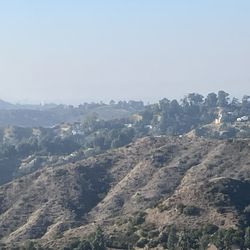
If you are looking for an easy, scenic trek up to a breathtaking view, then this is the wrong hike for you! You have to put in some good sweat to climb what seems to be a neverending incline all the way to the top. This review will just focus on the trails that start at Deukmejian Wilderness Park, but there are definitely other routes you can take. Parking is free and usually plentiful at this park and restrooms are clean. We first took the Crescenta View Trail and came down via the Rim of the World Trail, roughly 10 miles roundtrip. Both begin at the Deukmejian Wilderness Park parking lot, so it is a loop if you take this route. Of course it is possible to go up Rim and come down via Crescenta as well. Expect a nearly 3,000 ft elevation gain through many switchbacks and at times, narrow cliffside paths. You'll feel colder temperatures as you near the summit. We went in mid-January and saw bits of snow here and there at the top. Things to bring: -Consider wearing hiking shoes because there are some sections with a lot rocks that can disorient the footing of people wearing just running shoes. -Bring lots of water, especially in warmer weather since this is one of the longer hikes. -Wear sunscreen; there are some trees, but overall there is very little shade. -Consider printing a map from: https://hikingguy.com/hiking-trails/best-la-hikes/hike-mt-lukens-from-deukmejian-wilderness-park/. While we were going up we did not see a single person so it is easy to lose track of where you are if it's your first time on the trail and cell phone reception is spotty. tl;dr: A tough, local workout for a smoggy view of the land below on top of the highest elevation (a bit over 5,000 ft) within Los Angeles City limits. read more


Hiking to the top of Mount Lukens had been a goal of mine this past year. My friend Kris A. and I had made numerous attempts throughout the year, but we could never quite make it all the way to the top. Info on Mount Lukens: Mount Lukens is the western most peak of the San Gabriel Mountains and it's the highest peak within the Los Angeles City (not County) limits at 5,115 feet. There have been numerous fires in the area and the latest one was the Station Fire of 2009. The CV Trails Crew had worked consistently at reopening the trails which was a lot of work. They are continually working on the trails and are always looking for volunteers to help. Details of attempts to get to the top as follows: Kris A. and I failed at our first two attempts earlier in the year after I got struck by acrophobia on some of the narrow trails (Rim of Valley Trail & Crescenta View Trail) with heavy duty drop offs. We also tried to get to the summit via Angeles Crest Hwy. and the first ranger station north of the 210. It is about 7 miles one way via the Mount Lukens Truck Road and we made it about 3 miles in (close to the Tee Pee) before we turned around. The thought of hiking 14 miles is a little daunting, so we didn't rush back to try that route again. At the end of October we made our fourth attempt to get the top of Mount Lukens via the Rim of Valley Trail on the west side of Deukmejian Wilderness Park, but we got really tired and turned around after about 2 miles up. We thought there was only about 1 mile more to the top, but we were off by another mile. It is approximately 4 miles one way via Rim of the Valley Trail in Deukmejian Wilderness Park. Fast forward to Sunday, December 15th. I texted Kris A. to see if she had time to hike since I just felt like blowing off Christmas shopping once again. She was at my house in thirty minutes and we were headed to Deukmejian Wilderness Park. We had no intentions of trying to get to the top, but we just couldn't stop once we got started. I hate to admit that I didn't bring enough water. I had one big bottle, but three would have been better. I saved half for my trip back down, but it felt like my throat was raw by the end. If you go take plenty of water and lunch. You'll need it. In the end it was about 4 miles and 3,126 in elevation gains to get to the top via Rim of the Valley Trail. We saw about a handful of other hikers and one dog on the way up. The view is incredible up there. You can see past the Verdugos and Griffith Park all the way to the ocean to the west facing and south facing beaches. When we were on our way back down we really wanted to take a short cut because we needed to get back down by mid day. We decided to take the full loop of Deukmejian and we headed east on the Mount Luken's Truck Road toward Angeles Crest Hwy. The fire road intersects the Crescenta View Trail in about a mile from the towers. There are no real good markers, but there is one post with a number and you can pretty much look down and see the big Deukmejian Barn. This trail is very narrow in a lot of parts and there is also a lot of loose shale so you really need to watch your step. You also need to wear pants because the brush will be rubbing against your legs. Miscellaneous Info: -The hike to the top and back down is about 8 1/2 miles and there are two major trails you can take from Deukmejian. One is Rim of the Valley and the other is the Crescenta View Trail. The Rim of the Valley is the easier of the two routes and not as steep. -I would recommend this advanced hike if you are totally prepared with lots of water, food, hat and sunscreen. Bring a back-up battery to charge your phone. - There are other ways to the top of Mount Lukens as follows: Stone Canyon Trail - See reviews for Mount Lukens Via Stone Canyon Trail. Haines Canyon - A think you will add another mile or two to the distance. Mount Lukens Truck Road at first ranger station off Angeles Crest Hwy. - This will be a 14 mile round trip. Lots of mountain bikers pick this route. - There is no way to get picked up on the top unless you have a friend with a helicopter. Calling Sheriff's Dept. rescue might be a little expensive. read more


8 years ago
This hike actually have quite a few routes you can take to get to Mount Lukens. So you can change it up a bit and knock these out if you live close by or just want say you did them all. We started from Deukmejian Wilderness Park. The parking area is free, so that's a plus. The park itself is well maintained, and the restrooms here are pretty good. This is a tough 10 mile RT, that starts on the Crescenta View Trail and loops back down with very little shade from the sun. So plan accordingly if you're hiking this during the summer. I suggest printing out a map as you don't want to get lost in this long 10 mile loop, we used the hikingguy website, as he actually wrote a great turn by turn detail to summit Mount Lukens and has a trail map of the area. Other than that, the hike was fun, the views were great going up and at the radio towers. We didn't see a lot of hikers, so that was refreshing. There could be more trails, but here are the other alternative routes if you want to try out. Via Stone Canyon - 9 mile RT Via Haines Canyon - 8.5 mile RT As always, pack accordingly to the weather and have fun. read more


There are multiple ways you chose to take to get to the peak. We began our 10.8 mile journey at Deukmejian Wilderness Park via Rim of the Valley Trail. After you park, be sure to use the restrooms that are available (just be prepared to get a quad workout) Within the first 5 mins we ran into a volunteer who was planting trees. He suggested we take the Rim of the valley trail, he also claimed it was a 3.5mile trek to the peak. He lied. We started our journey in the direction the old man pointed us in. The first mile wasn't too bad, lots and lots of switchbacks. After the first mile we began our descend downward. This was one of my favorite parts, we were shaded under the trees and the smell of the rain from the night before enhanced the whimsical feeling. Also the running water in the creek added a nice calming charm. Just be carful... some of the plants look a little questionable and you don't want to end up with poison oak. After this we continued our journey up. At 4 miles (according to my GPS) I was getting a little tired. The incline had been steady the entire time with no hope of relief. However we could see the peak and there was no way we were turning around. So after a water and snack break we continued up the mountain. Finally after 5.6 miles and 2 1/2 hours up the mountain we made it to the peak. This was the first time that I was almost too tired to enjoy my conquest. Also when we reached the top the temperature dropped and my sweat soaked t-shirt refused to provide me with any warmth. I was excited (perhaps a little too enthusiastic due to weakness) to find the Geo catcher and add my name to the little book. Since we were on a time frame, and because I thought I was freezing (it really wasn't that cold, I was just tired at this point) we began our journey down. This hike was a killer workout. It took us 4 hours to complete the 10.8 mile hike. The biggest sense of accomplishment comes not at the peak of the mountain, but rather when the journey is over and you stand in awe looking up at the point you came from. This hike is definitely worth a try. Bring water, a partner, and the attitude that you are going to complete it, and don't loose that attitude during the last mile up when your legs go numb from the prolonged exposure to lactic acid build up. read more


You can access Mount Lukens from various trails coming from the North, West and South. I chose to access it from the South from Deukmejian Wilderness Park located in Dunsmore Canyon in the City of Glendale. From this starting point you can take the Rim of the Valley Trail or the Crescenta View Trail to the summit. I chose the Rim of the Valley Trail. It was a 10.8 mile round trip hike and it took me 4 hours to complete. You can also complete a loop by combining both the Rim of the Valley and Crescenta View Trails. The summit reaches an elevation of 5,075 feet which is the highest elevation within Los Angeles City limits. I went on a Sunday morning and the parking lot at the Wilderness Park was pretty crowded. Fortunately parking is free and you don't need an Adventure Pass. Within the first mile of the hike you will descend into the canyon where you will encounter lush foliage and a small stream. At one point you will need to walk along a fallen tree and hop over various puddles. You will then approach some wooden stairs and a fallen bridge to begin your ascent up the mountain. The trail then transitions to steep switchbacks and a narrow cliffside trail that has some great views. The day I went the weather was cool and parts of the trail had some shaded areas. The final leg consists of some long switchbacks leading up to the communication towers. There is a definitely a temperature change the last mile of the hike and your sweat-soaked shirt also does not help matters. Be sure to bring along a lightweight sweatshirt if you plan to reach the summit. At the summit you'll encounter an antenna farm. I never like to hang out too long around radio and television broadcast antenna towers. I just don't know what effects the powerful high frequency radio waves are having on my body. There are even posted signs warning how you are exceeding the FCC limits of safety by being too close to the base of the towers. Before you descend down the mountain, be sure to try and find the Geocatch and the survey mark. I won't give away the location but it might be located somewhere near a propane tank. read more


Holy crap, now this is a serious hike!!! Lots of water, food, sunscreen are highly recommended. Our MapMyHike app said the distance was a little over 13 miles roundtrip starting from Haines Canyon Ave. Directions to this starting point are confusing on other online resources but I figured out that if you map yourself to this address, it takes you right to the entrance. 10501 Haines Canyon Ave, Tujunga, CA 91042 Park on that uphill street near the top of Haines Canyon Ave. It is an uphill residential street with a gated dead end at the top. The gate at the dead end is the entrance to the hike. You will see a dam as you walk in. As you keep following the trail, a couple of miles ahead, you will eventually notice a split and might ask yourself, "Which way to go?" Keep RIGHT when you see this split. Later on, you will cross over a dry creek and the approach a "ROAD CLOSED" gate. Go past this and it is ALL incline from there. The trail will continue up and keep going...and going...and going...on for MILES. The goal is to get to the very top where the few antenna towers are. Once you make it, after 6.5 miles up, you're at the highest point of elevation in LA city limits!!! Congratulations!!! Power through, drink water and feed yourself on this trek. read more


8 years ago
Mt. Lukens is not as glamorous as Mt. Baldy or Baden Powell, but I come here often because it is much closer from where I live. At times, I feel like driving less and hike more even though the cost is "not so great views" or "less shades from mature forests." You can get there by 5 different ways - with approximate distance. 1)Stone Canyon Trail - 8 Miles, 3,200 ft gain 2)Haynes Canyon Trail - 10 Miles, 2,900 ft gain 3)Rim of the World Trail - 10.4 Miles, 2,800 ft gain 4)Crescenta View Trail - 9 Miles, 2,800 ft gain 5)From Angeles Crest Highway - 12+ Miles, Elevation Gain est. 2,600(?) ft. 1)Stone Canyon - I would not go there because trail is very fragile. It is not worth it. Trail head is from Big Tujunga Road from Sunland. 2408 Stoneyvale Rd. 2) Haines Canyon - Neither. Not well maintained and boring. TH is near Haines Debris Basin at Tujunga. 3)4)Rim of the World and Crescenta View - these two starts from the same trail head at Deukmejian Wilderness Park at Glendale. 3429 Markridge Rd. Glendale. RW veers to left at about .25 miles from start and CV veers to right. 5)From Angeles Crest Highway - not recommended. wery long and unspectacular. TH is about 5-10 miles from La Canada. If you want less steep and overall gain, then do RW. If you prefer steep hiking, then do CV. The first one and half hours is steep and very good workout. As for the location of Deukmejian Wilderness Park, you can google it easily. Free parking and clean bathroom. So my favorite path is going up via CV and coming down via RW. The whole thing will be about 10 miles. Lastly, make sure you hike early in the morning if you go there during Summer time. The park opens at 7:00 a.m. read more


12 years ago
The hike to Mount Lukens is about 9-10 miles round trip, depending on the trail chosen. There are multiple trails leading here. Stone Canyon trail is more difficult than Deukmejian trail, but they are both good workouts and mostly unshaded. The views from the top are nice but not so clear with all of the smog. The weather here seems somewhat unpredictable. When hiking during an overcast and slightly rainy summer day, the winds were really blowing and it was cold. But hiking a 2nd time during a warm summer morning resulted in almost no wind, and it was still warm at the top. I wouldn't hike here for the views only, but for the work that it takes to get here. After all, it is the highest peak in Los Angeles!! read more


8 years ago
7 years ago
More info about Mount Lukens
Haines Canyon Mountainway
Tujunga, CA 91042
Tujunga
Directions
Hours
Outdoor Amenities
Ask the Community - Mount Lukens
Review Highlights - Mount Lukens
You might also consider


Mount Lukens - hiking - Updated June 2026
Best of Tujunga
People found Mount Lukens by searching for…
Scenic View in Tujunga, California
Beaches in Tujunga, California
Hiking Trails in Tujunga, California
Stairs Workout in Tujunga, California
Shaded Hike in Tujunga, California
Things to Do in Tujunga, California
Scenic Drives in Tujunga, California
Beautiful Views in Tujunga, California
Hiking Club in Tujunga, California
Easy Hikes in Tujunga, California
Running Trails in Tujunga, California
Off Road Trails in Tujunga, California
Places to Walk at Night in Tujunga, California
Canyoneering in Tujunga, California
Lookout Points in Tujunga, California
Nature Parks in Tujunga, California
Walking Trails in Tujunga, California
Hiking Groups in Tujunga, California
Browse Nearby
BEST of Tujunga, California Restaurants near Mount Lukens
BEST of Tujunga, California Coffee near Mount Lukens
BEST of Tujunga, California Things to Do near Mount Lukens
BEST of Tujunga, California Parks near Mount Lukens
BEST of Tujunga, California Lakes near Mount Lukens
BEST of Tujunga, California Breakfast near Mount Lukens
BEST of Tujunga, California Campgrounds near Mount Lukens