Cancel

    Open app

    Search

    Grizzly Flats Trail

    5.0 (1 review)

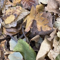
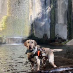
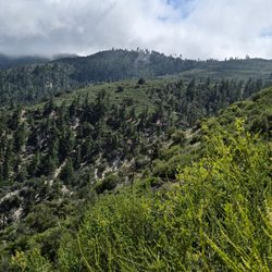
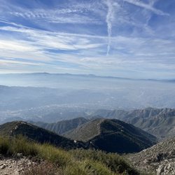
    Grizzly Flats Trail Photos

    You might also consider

    Recommended Reviews - Grizzly Flats Trail

    Your trust is our priority, so businesses can't pay to alter or remove their reviews. Learn more about reviews.
    Yelp app icon
    Browse more easily on the app
    Review Feed Illustration

    8 months ago

    Helpful 9
    Thanks 3
    Love this 7
    Oh no 0

    You might also consider

    Verify this business for free

    People searched for Hiking 11,805 times last month within 15 miles of this business.

    Verify this business

    Trail Canyon Falls

    Trail Canyon Falls

    4.6(119 reviews)
    3.1 mi

    This hike was interesting, but for me it was definitely more difficult and a lot more dangerous…read morethan I expected. The first part of the trail, down to the creek and along the creek, was not too hard and actually pretty enjoyable. Crossing the creek several times was fun, and there were some nice shaded areas along the way. We also saw a California newt, which was really interesting -- but please do not touch them. Later, when we finally had internet again, we read that their skin produces a toxin, so it's best to admire them from a safe distance. The harder part starts after you climb above the creek. From there, the trail leading toward the waterfall becomes narrow and slippery, and on the right side there are steep drop-offs almost the entire way. The final descent to the waterfall was the biggest challenge for me. You have to go down along the rock with a rope for support, but honestly it did not look safe at all, so we decided not to go all the way down to the base of the waterfall. I would not bring children on this hike. Also, be prepared that the round trip can take around 3.5 hours depending on your pace. A few helpful things to know: * parking was along the road * there are no restrooms * tickets/permits need to be purchased in advance in a different place * internet service was very poor, so it's better to download your map ahead of time * there were not many people, which was nice The waterfall was full and rushing, and the views were beautiful, but personally I would not do this hike a second time.

    A scenic trail nestled in the Tujunga Mountains, this hike was the perfect choice for my friends…read moreand me. We picked this spot because it's slightly removed from the fire damage of last year, yet still close enough to LA for a convenient trip. First things first, this trail is located in the Los Angeles mountains and requires an Adventure Pass ($5). You can pick one up at designated spots (which, by the way, supports the forest), and it must be displayed on your dashboard with the date scratched out. I saw many cars without the Adventure Pass, but from my understanding, you could get a ticket, so it's your call. I would rather get the $5 Adventure Pass than a ticket which could cost you maybe $50+. Also, I highly recommend getting there early for two reasons: 1. To secure a parking spot 2. To beat the heat. We arrived early enough to find parking, and as we set out on the trail, I was struck by how beautiful it was. The hike is about 4 miles in and out. At the start, there's little shade, but as you continue, you'll cross several streams and find shaded spots along the way. There's even a section where you'll need to use ropes to descend, eventually reaching the base of a waterfall. The trail is quite popular, so by the time we got to the waterfall, there were lots of people taking photos. The descent was manageable, but be prepared to wait for others when you head back up the ropes. There was a bit of a line to ascend, which slowed things down a little before we headed back to the car. All in all, it's a fantastic trail. Having lived in the area for many years, I'd definitely consider it one of my favorites. The variety of trails, different terrains, and water crossings make it a unique experience. Just don't forget to bring waterproof hiking boots for the water crossings. Enjoy!

    Photos
    Trail Canyon Falls
    Trail Canyon Falls
    Trail Canyon Falls

    See all

    Switzer Falls - USDA Forest Service

    Switzer Falls - USDA Forest Service

    4.4(293 reviews)
    4.6 mi

    Perfect hike for a hot day…read more I love waterfall hikes and listening to the sound of calm, running water. The added challenge on these hikes is the multiple stream crossings. I brought some hiking poles which helped with balance and probing for loose rocks and logs. If you want to get parking in the lower lot, it's best to come before 8AM. We found parking in the second lot. An Adventure Pass or Day Pass is required. Parking is enforced. A car received a ticket for being in a No Parking zone. The start of the trail is nicely shaded. The second half is a hilly, narrow, sun exposed path which routes back into the canyon toward the Lower Switzer Falls. I'm glad they had fencing on some narrow and steep parts of the trail. We encountered an active rattlesnake which headed down the mountain, so be on the lookout. Overall, the hike takes about 3 hours for 5.5 miles. The additional hike back up to the parking lot was about 1/4 of a mile. Note: if you need to use the restroom, it's best to bring your own toilet paper and to go before you start your hike. It was kind of smelly, but if you gotta go... you gotta go.

    This place is great for fully appreciating nature! The trail is around 5-5.5 miles round trip,…read moredepending on where you park. What impressed me most about this trail is that it's almost fully covered by shade. We went in the late afternoon, and I'd say probably 80-85% of it is covered. Very impressive! Here are some useful tips: 1. There are three parking lots: two are next to the highway, and one is near the hiking entrance. I'd recommend getting a parking pass if possible. 2. There are only three restrooms at the beginning of the trail, so use them when you see them. 3. If you're aiming to go to the waterfall, make sure to look for the signs. Some signs aren't very clear, so we had to stop and ask other hikers frequently. Luckily, people there are super friendly and happy to help. Just pay attention to your surroundings. 4. The trail is dog-friendly, but dogs must be on a leash. 5. Waterproof hiking boots are recommended. All in all, it's a fun trail. It's a great place for a picnic and camping, and it's very close to the stream. Great for kids, families, and pets!

    Photos
    Switzer Falls - USDA Forest Service - Lower Switzer Fall

    Lower Switzer Fall

    Switzer Falls - USDA Forest Service - The grand prize, Switzer falls.

    The grand prize, Switzer falls.

    Switzer Falls - USDA Forest Service

    See all

    Gabrielino Trail - Playing in the dam

    Gabrielino Trail

    4.3(80 reviews)
    7.1 mi

    This is a beautiful trail that is well used by locals. You can start the trail at a parking lot by…read moreJPL. The parking lots is large so it can accommodate a lot of hikers. You should put out your adventure pass when parking at this lot. I am not sure if anybody is checking but its best to be safe, to avoid a ticket. From the parking lot to the dam its approximately 8.4 miles roundtrip. The hike has very limited elevation gain to the dam- and it follows along the river. You will have to cross the river multiple times to the dam. Some of the crossing will be on bridges while others will require to get your feet wet or hop rocks to get across. The trail is mostly cover by trees so provide some relief from the sun. The Gabrielino trail leads to many other trails and places beyond the dam- you actually start on this trail and go all the way to another waterfall- note this hike is approximately 19 miles and has over 2500 feet elevation. The trail is heavily used by bikers, hikers, walkers and horseback riders. On the weekend this trail gets very busy. If you want peace and quiet best to do this trail during the weekdays early in the morning. Currently (October 2025)- some construction is going on at the beginning of the trail. The start of the trail can be closed- so before heading out check to see if the trail is open.

    Beautiful trails. Feels like you're out of LA. Highly recommend. Dog friendly. Pretty easy parkingread more

    Photos
    Gabrielino Trail
    Gabrielino Trail
    Gabrielino Trail

    See all

    Big Tujunga Canyon

    Big Tujunga Canyon

    4.8(5 reviews)
    4.0 miSunland

    This was definitely a medium to hard trail in the summer because of the heat and some of the areas…read morethat require one's attention as there is a hillside next to you. We started at 9am ish and I would definitely start at 7am in the future because of the heat in august. The water fall was still there! People got in and the water was refreshing and cool. We found that tadpoles were transforming into frogs in the water so I recommend mindfulness to not step on them as they learn how to properly swim! Tips from our hike and waterfall visit: - we had sufficient water and first aid kit - we took various water breaks - we added mosquito repellent as are some - we had all trails gps to help us navigate trail first time - bring shoes with good ankle support - I would bring electrolytes next time - I would do 3-4-snacks vs. 1-2 next time

    Birthday Shaynanigans at Tujunga Falls !!…read more Decided to go on a little adventure on my birthday and got out of San Diego to explore Tujunga Falls. Don't forget to get an adventure pass if you plan to park alongside the road or you'll get a ticket ! It's October so the falls were DRY. Boo. I would love to go back when we get a bit more rainfall, because the waterfalls were non-existent at this time. We ended up calling it 'invisible' falls. Other than that, the hike was great ! It's about 6 miles round trip and took us about 3 hours including taking pictures and testing out a friend's drone ! He's sooo cool ! LOL. Plenty of breathtaking views and the trails were wide enough for a group of hikers. Things to note: Start early so you can avoid the heat ! This will determine how long the hike will take you ! The sun was unforgiving so be prepared ! 'Trail' and 'waterfall' signs will help guide your way ! You'll also notice cabins at the beginning of the trail. After about a mile, you'll experience more of an incline so make sure to stay hydrated. There's barely any shade on this trail so bring a hat and sunscreen as well ! Poison ivy everywhere ! I had a traumatic experience in 6th grade camp when I got poison ivy. I made sure to cover my arms and legs this time just to take precaution. Rattlesnakes !!! We spotted one !!! Eek !! Be cautious of your surroundings. Unstable log bridges !! There was barely any water so hopping on the logs was an option, but do be careful because some are barely stable. Good to have some proper hiking shoes for this. Overall, most of the crossings and lack of water made it easy to traverse. As we got closer to the falls, we found a major descent and a climbing rope which guided us towards the waterfall (or invisible fall). The rope helped aid us up and down the mountain which was great ! Once you reach the waterfall (invisible falls) you'll enjoy the much needed shade and it was a perfect spot to take a fruit break ! We packed some oranges and apples with us ! There's plenty of spots to sit, relax, and enjoy nature ! Overall, it was a pretty good workout for moderate and advanced hikers ! We definitely made a few stops to take pictures and videos of our surroundings ! It was so calm and peaceful ! Perfect time to enjoy mother nature ! We will definitely come back to experience the REAL DEAL of the waterfalls ! Go out there and hike friends !!

    Photos
    Big Tujunga Canyon - Snow day

    Snow day

    Big Tujunga Canyon
    Big Tujunga Canyon

    See all

    Falls Creek Falls

    Falls Creek Falls

    4.0(12 reviews)
    3.2 mi

    Beautiful trail with views of Big Tujunga Canyon and, as promised in the name, a multi-tiered…read morewaterfall. The trail is well maintained with several parking spots at the trailhead. It's only downfall (haha) is that it's all downhill at the start and all uphill on the way back. But, don't worry, it's not super steep and the views are worth it. To see the waterfalls close up, you do have to clamber over some rocks, follow along the creek, and eventually cross the creek (bring your waterproof boots.) As of this date, the creek had a decent current, so be careful. As always, bring water and your mobile tracking device (I've watched one to many "disappeared on the trail and never seen again" videos, sorry!). And enjoy.

    First thing to know if you plan on going to the waterfall is you will get wet in the creek at the…read morebottom, and you should wear covering pants for your legs and long sleeves because there are a lot of overgrown plants here along with poison ivy or oak. Really I rate this as a 3 1/2 star but going down with the curve score due to the elements and conditions. Falls creek falls trail head is about 6-7 miles away from Trail Canyon Falls on Big Tujunga and only a mile away from the Big Tujunga Dam overlook. The trail going down to the creek is easy to follow but is has a lot of rocks and overgrown plants all over the trail so I would recommend coming here with your kids or pets. Once you're at the bottom there's a spray painted arrows on one of the rocks pointing to the right, that's the path to stay on the trail to go wherever it leads to. If you're heading to the waterfall go left and walk through that creek. I'll admit I wasn't about an hour trying to avoid walking through the water in the creek and I probably fell into some poison ivy and might also have Lyme disease because of all the plants I went climbing through. Do yourself a favor, don't waste your time trying to make a path away from the water, just go through the creek. It's maybe shin high and the water is clear enough that you can see where you're stepping. Closing this long ass review up, this is So Cal and it barley rains. Best time to check this waterfall out of the week right after it rains so you can see a decent flow. I came here a month after the winter rain we got and it's almost dried up again. This trailhead is in the Angeles National Forest so you'll need to display your adventure pass when you park.

    Photos
    Falls Creek Falls
    Falls Creek Falls
    Falls Creek Falls

    See all

    Mount Lukens

    Mount Lukens

    4.5(11 reviews)
    1.4 miTujunga

    This is the highest point in the city and a decent leg burner if you do the loop ascending…read morenortheast from Deukmejian Wilderness, head west to the peak and descend southwest. Plated shoes and hydration vest are a must on this loop. A machete would have been nice on the last part of the descent due to overgrowth.

    If you are looking for an easy, scenic trek up to a breathtaking view, then this is the wrong hike…read morefor you! You have to put in some good sweat to climb what seems to be a neverending incline all the way to the top. This review will just focus on the trails that start at Deukmejian Wilderness Park, but there are definitely other routes you can take. Parking is free and usually plentiful at this park and restrooms are clean. We first took the Crescenta View Trail and came down via the Rim of the World Trail, roughly 10 miles roundtrip. Both begin at the Deukmejian Wilderness Park parking lot, so it is a loop if you take this route. Of course it is possible to go up Rim and come down via Crescenta as well. Expect a nearly 3,000 ft elevation gain through many switchbacks and at times, narrow cliffside paths. You'll feel colder temperatures as you near the summit. We went in mid-January and saw bits of snow here and there at the top. Things to bring: -Consider wearing hiking shoes because there are some sections with a lot rocks that can disorient the footing of people wearing just running shoes. -Bring lots of water, especially in warmer weather since this is one of the longer hikes. -Wear sunscreen; there are some trees, but overall there is very little shade. -Consider printing a map from: https://hikingguy.com/hiking-trails/best-la-hikes/hike-mt-lukens-from-deukmejian-wilderness-park/. While we were going up we did not see a single person so it is easy to lose track of where you are if it's your first time on the trail and cell phone reception is spotty. tl;dr: A tough, local workout for a smoggy view of the land below on top of the highest elevation (a bit over 5,000 ft) within Los Angeles City limits.

    Photos
    Mount Lukens
    Mount Lukens
    Mount Lukens

    See all

    Grizzly Flats Trail - hiking - Updated May 2026

    Loading...
    Loading...
    Loading...