Hoyt Mountain Photos

You might also consider


More like Hoyt Mountain
Recommended Reviews - Hoyt Mountain
Start your review...



5 years ago
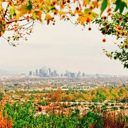
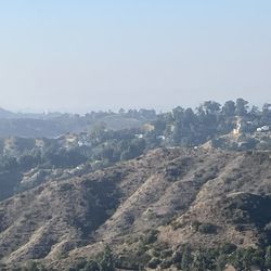
A good hike but better to save for a backup when other better hikes are unavailable due to cold weather, fire closure, or full parking lots. When in this area, head to Josephine (see www.yelp.com/biz/josephine-peak-palmdale-2) or Strawberry (see www.yelp.com/biz/strawberry-peak-los-angeles) Peaks instead. But if not possible, try Hoyt Mountain because it's at an elevation too low for snow which means the trail is likely accessible after a winter storm. From the 210 freeway, drive 6.2 miles north on Angeles Crest. The parking lot pull-out is on the left. The only identification is a sign to the left of the trail that says "Grizzly Flat Trhd" (see pic). A poorly named sign because most people go to Grizzly Flats from Big Tujunga Canyon Road, not Angeles Crest Hwy. You've gone too far if driving under the power lines. I displayed my annual park pass but none of the dozen other cars had passes. Although I can't find anywhere on the National Forest Service sites that specifically states if a pass is needed for this trailhead but it "seems" that no fees are needed when parking along Angeles Crest between the La Canada entrance and the Switzer picnic area. This trail to Hoyt Mountain starts as a dirt road appropriately called Hoyt Mountain Road. Alternatively, Hoyt Mountain is also reachable from Georges Gap or Clear Creek. When clear, the ocean is visible a half-mile up the road. The road is 1.8 miles one way with 825' elevation change to a saddle but a bad place to stop because of the overhead power lines. The final leg of the hike from the saddle to Hoyt's summit is steep by any hiking (not rock climbing) standard. The rapid 560' elevation difference is done in a thankfully brief 0.45 miles one-way. The trail is not a road but a narrow track along the ridgeline. If unwilling to go the entire distance like many we saw, at least climb the first section to get away from the electrical lines. Nothing at the peak like towers or trees to prevent a 360-degree view that includes Pasadena and Downtown LA and further to the ocean (see pic). The complete journey was 4.6 miles roundtrip with a 1385' gain. read more