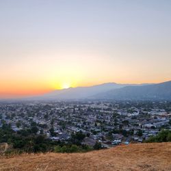
Lewis Falls Photos


You might also consider
More like Lewis Falls
Recommended Reviews - Lewis Falls
Start your review...

Reviews With Photos
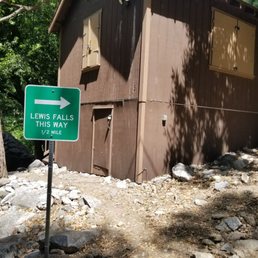
A hidden treasure for sure!! My friend and I have been looking for all sorts of trails to try! This hike was short and fairly easy to get to. Make sure you look up this hike before you go as there is NO trail marker. Basically to get to this hike, you will take Azusa (State route 39) going towards the mountains for about 15 miles or so. The entrance to this trail is between highway marker 34 and 35! There are some spots to park at right here, so if you go past either of those markers, you missed the entrance to this waterfall. I am not sure if you need the "adventure pass" parking. We did not have one and we did not see any signs saying we needed one. We did see signs saying you needed the parking pass at the forks below before reaching this trail. The hike itself is pretty short, a little over a mile. It is well shade, but there are bugs, so make sure you bring your bug spray!! We sprayed ourselves down as well as the dogs with bug spray before entering the trail and brought it also in case. The hike gradually inclines in elevation, but it is not really noticeable. There is however, some rock scrambling at parts and the walkway is quite narrow in some spots, as well as low spots where you have to go under a fallen tree. I got stuck because my backpack stuck out and so I had to take if off to go through the smaller opening under the tree. There are 2 spots where you go under a tree. The first is much bigger, but the second is a tighter squeeze. We had our dogs. She had a 25lb Shiba and I had my 105lb German Shepherd and there is a huge size difference them! Both made it. She had to pick up and carry her dog at some parts. I was a bit worried about my boy having to climb over rocks, more worried about him getting DOWN the rocks safely as some of the paths are narrow and I was scared about him hurting himself on rocks and branches. He made it okay though. However and he is not the most agile dog. Just keep that in mind if you bring a large dog with you. With the obstacles and width of path in mind, if your dog is good on recall, it is actually safer to just have them off leash if there are no other people around. The path was definitely too narrow for my guy to be walking side by side with me. My guy was off leash until we saw the other dog... then I leashed him until they passed and again on the return trip when we could start hearing cars. There was a couple that came after us also with a German Shepherd and they continued past the waterfall. If you go past the waterfall, it is VERY steep and rocky!! I would not recommend it with a dog, or even the average person! We watched the guy as he basically carried the shepherd up and wondered how on earth they were going to go back down safely. They were the only other people/dog we saw on the trail. All the other people we saw went to the other side of the highway to the water below. The waterfall was excellent!! Water was crystal clear and it was flowing in full force! My boy absolutely loved playing in the water!! Aside from some rock scrambling, this hike was excellent and easy and well shaded. Lots of spots to stop and take pictures and to play in the water. I loved that it was also not crowded!! Would I come back? Yes I would! I love waterfalls and so does my boy! Who knew this gem was so close to home!! I just hope it stays uncrowded!


Its a hidden spot theres no signs so make sure you follow the exact lin point of your maps app. Theres no parking so parki alongside the road if find an open spot. Only way i found the opening was from people exiting the spot. It was off putting to see people disposing their trash right by the opening i guess people camp around here.. I would rate the hike moderate theres no guided path so use yoir instincts to navigate through here. You will reach a point to proceed once you reach the waterfall with a rope to climb up. I didnt go up i think its smarter if you bring gloves and good hiking boots cuz there are large rocks and boulders to climb over Please dont leave a trace read more


4 years ago
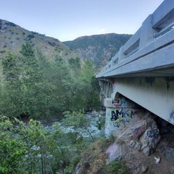
The most difficult part is finding the start of the trailhead. Once you pass the graffiti tower, you are close! You'll also see some signage saying North Fork. I would keep an eye out for an opening in overgrown vegetation. It is off the 39. The cars parked out front help as well. There is limited parking and I'd say 10-12 cars max fit on the same side of the trailhead. Pros: clean and secluded. I think I counted about a dozen people total on my hike in and back. Con: short lol The trail has a good amount of shade and smaller falls and streams along the way. You'll transverse several rocks and low crossings and fallen trees so waterproof boots are best. I had my 65lbs senior pitlab mix with me on our hike. I had to lift and carry him over some of the rocks. Since it rained yesterday, portions of the trail were muddy. Visited on 1.16.22 read more


A hidden treasure for sure!! My friend and I have been looking for all sorts of trails to try! This hike was short and fairly easy to get to. Make sure you look up this hike before you go as there is NO trail marker. Basically to get to this hike, you will take Azusa (State route 39) going towards the mountains for about 15 miles or so. The entrance to this trail is between highway marker 34 and 35! There are some spots to park at right here, so if you go past either of those markers, you missed the entrance to this waterfall. I am not sure if you need the "adventure pass" parking. We did not have one and we did not see any signs saying we needed one. We did see signs saying you needed the parking pass at the forks below before reaching this trail. The hike itself is pretty short, a little over a mile. It is well shade, but there are bugs, so make sure you bring your bug spray!! We sprayed ourselves down as well as the dogs with bug spray before entering the trail and brought it also in case. The hike gradually inclines in elevation, but it is not really noticeable. There is however, some rock scrambling at parts and the walkway is quite narrow in some spots, as well as low spots where you have to go under a fallen tree. I got stuck because my backpack stuck out and so I had to take if off to go through the smaller opening under the tree. There are 2 spots where you go under a tree. The first is much bigger, but the second is a tighter squeeze. We had our dogs. She had a 25lb Shiba and I had my 105lb German Shepherd and there is a huge size difference them! Both made it. She had to pick up and carry her dog at some parts. I was a bit worried about my boy having to climb over rocks, more worried about him getting DOWN the rocks safely as some of the paths are narrow and I was scared about him hurting himself on rocks and branches. He made it okay though. However and he is not the most agile dog. Just keep that in mind if you bring a large dog with you. With the obstacles and width of path in mind, if your dog is good on recall, it is actually safer to just have them off leash if there are no other people around. The path was definitely too narrow for my guy to be walking side by side with me. My guy was off leash until we saw the other dog... then I leashed him until they passed and again on the return trip when we could start hearing cars. There was a couple that came after us also with a German Shepherd and they continued past the waterfall. If you go past the waterfall, it is VERY steep and rocky!! I would not recommend it with a dog, or even the average person! We watched the guy as he basically carried the shepherd up and wondered how on earth they were going to go back down safely. They were the only other people/dog we saw on the trail. All the other people we saw went to the other side of the highway to the water below. The waterfall was excellent!! Water was crystal clear and it was flowing in full force! My boy absolutely loved playing in the water!! Aside from some rock scrambling, this hike was excellent and easy and well shaded. Lots of spots to stop and take pictures and to play in the water. I loved that it was also not crowded!! Would I come back? Yes I would! I love waterfalls and so does my boy! Who knew this gem was so close to home!! I just hope it stays uncrowded! read more


4 years ago
Nice, short , shaded, kid and pet friendly Waterfall Trail. The trail has no signs; it's kind of hidden. I visit trail 10.16.2022 and capture some great picture. read more


4 years ago
Peaceful hike me and my family enjoyed it. The entrance is very hidden. The hike is a bit challenging if you have kids. My 2 year old did it though. It was very green and wet when I went like a fairytale. read more


5 years ago
5 years ago
Short mile hike, there's beauty in each step you take that leads to a refreshing waterfall. I'm definitely going back this summer. read more


More info about Lewis Falls
Azusa, CA 91702
Directions
Hours
Outdoor Amenities
Ask the Community - Lewis Falls
You might also consider


Lewis Falls - hiking - Updated June 2026
Best of Azusa
People found Lewis Falls by searching for…
Hiking Trails With Waterfalls in Azusa, California
Things to Do in Azusa, California
Waterfalls and Swimming Holes in Azusa, California
Abandoned in Azusa, California
Hiking Trails Kid Friendly in Azusa, California
Waterfalls in Azusa, California
Hikes With Dogs in Azusa, California
Dog Friendly Lakes and Parks in Azusa, California
Off Road Trails in Azusa, California
River Swimming in Azusa, California
Swimming Lakes in Azusa, California
Easy Hiking Trails in Azusa, California
Scenic View in Azusa, California
Lakes & Ponds in Azusa, California
Tent Camping in Azusa, California
Secret Spots in Azusa, California
Splash Pad in Azusa, California
Trending Searches in Azusa, CA
Black Owned Nail Salons near Lewis Falls
Cliff Jumping near Lewis Falls
Dog Friendly Trails near Lewis Falls
Fishing Spots near Lewis Falls
Jet Ski Rental near Lewis Falls
Lakes & Ponds near Lewis Falls
Off Road Trails near Lewis Falls
Outdoor Activities near Lewis Falls
Places To Walk Around near Lewis Falls
Public Shower near Lewis Falls
River Swimming near Lewis Falls
Scenic Night View near Lewis Falls
Scenic Overlook near Lewis Falls
Secluded Spots near Lewis Falls
Strawberry Picking near Lewis Falls
Swimming Holes near Lewis Falls
Browse Articles
Browse Nearby
Browse Brands
Related Searches in Azusa, CA
Best Fishing Locations and Guides in Azusa, California
Best Nature Trails for Hiking in Azusa, California
Best Places for Horseback Riding in Azusa, California
Check Out Off Road Trails in Azusa, California
Discover Dog Friendly Trails to Explore in Azusa, California
Discover Kid Friendly Hiking Trails in Azusa, California
Discover Scenic Hiking Trails in Azusa, California
Discover Scenic Mountain Bike Trails Near Azusa, California
Discover Scenic Waterfall Spots in Azusa, California
Discover Top Nature Parks to Visit in Azusa, California
Discover Walking Parks in Azusa, California Near You
Discover a Hiking Trail in Azusa, California
Discover the Best Night Hike Trails in Azusa, California
Discover the Best Running Track in Azusa, California
Dog-Friendly Hikes With Dogs in Azusa, California
Enjoy Camping Adventures Around Azusa, California
Enjoy Exciting Mountain Biking Adventures in Azusa, California
Enjoy Kayaking Adventures in Azusa, California
Enjoy Tent Camping Spots Around Azusa, California
Enjoy a Beautiful Waterfall Hike in Azusa, California
Enjoy a Peaceful Nature Walk in Azusa, California
Enjoy the Best Walking Path in Azusa, California
Enjoy the Best Walking Trails in Azusa, California
Exciting Cliff Jumping Spots in Azusa, California
Explore Beautiful Parks and Green Spaces in Azusa, California
Explore Easy Hikes Perfect for All in Azusa, California
Explore Fun Activities to Do in Azusa, California
Explore Popular Campgrounds Near Azusa, California
Explore the Best Beach Spots in Azusa, California
Explore the Best Trail Options in Azusa, California
Family Friendly Hiking With Kids in Azusa, California
Find Beautiful Views in Azusa, California
Find Parks and Recreation Activities in Azusa, California
Find the Best Parks for Picnics in Azusa, California
Find the Best Scenic View Locations in Azusa, California
Great Places to Walk in Azusa, California
Hike the Popular Waterfall Trail in Azusa, California
Hiking Trails With Waterfalls in Azusa, California
Off Leash Dog Hiking Trails in Azusa, California
Plan a Scenic Drive Route Near Azusa, California
Popular Outdoor Activities to Try in Azusa, California
Popular Picnic Spots to Visit in Azusa, California
Safe River Swimming Areas in Azusa, California
Safe and Fun Parks for Kids in Azusa, California
Top Climbing Spots and Gyms in Azusa, California
Top Running Trails to Explore in Azusa, California
Top Swimming Lakes to Enjoy in Azusa, California
Top Swimming Spots and Pools in Azusa, California