Sugarloaf Peak Photos


You might also consider
More like Sugarloaf Peak
Recommended Reviews - Sugarloaf Peak
Start your review...

12 years ago
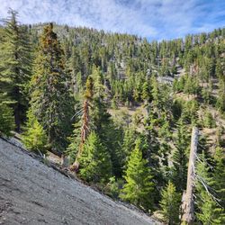
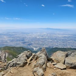
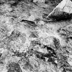
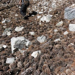
YOUCH!!! THAT''S GOING TO LEAVE A MARK! Background Sugarloaf Mountain is a large prominent peak at 9,952 feet in the San Bernardino Mountains and is the highest peak in the San Bernardino Mountains outside the San Gorgonio Wilderness. Ontario Peak, at 8,693 ft, is a high peak in the San Gabriel Mountains Stats Difficulty - 8/10 Miles - 14 Elevation gain - 6,000/7,000 feet Class 2-3 scrambling Bouldering Waterfall climbing (optional) Miles and miles of scree Essentials 4-liters of water Snacks & lunch Handy wipes for any BOT (Blood on Trail from the rocks) Gloves (gardening or work gloves-rocks are jagged) Knee pads (totally optional, thick pants should be fine) Helmet Electrolytes Sunscreen Hiking Poles Camera Headlamp Hat (optional) Our Route Starting North Mount Baldy Road, Mt. Baldy, we headed up Icehouse Canyon until we reached the first obvious switchback trail and followed the trail to the canyon. This is where the fun all started, or at least for a little while. For just a little over two miles and 4,000 foot elevation gain, we took one small step forward one huge slide back up mountain side of scree. Nearly jumping from one tree or bush root to the next was the best we could do to stop from sliding down the canyon. What a quad workout, not to mention lower back from all the baby crawling to the next "safe zone." Alas, after over three hours of jumping, grabbing, crawling on all fours holding on to whatever we could, we reach the top of the scree portion of the canyon. Sure did feel good to stand straight up again. From there we followed a trail when we could see it, made our own trail when couldn't until we reached the Ontario Saddle. Beat, beat-up, exhausted, and stiff, we sit for lunch. With food in our stomachs, much careful consideration and looking at the time, we decide it best not to continue onto Ontario Peak, instead head back down the mountain. Unfortunately, the shortest way down is the same way we came up. You know the saying, "it's all downhill from here" is typically meant to be a good thing, well, in this case, not so much. Although the scree hill makes for some magnificent scree skiing when heading down, one wrong step and you become a falling rock with no end in sight, at least not alive. The alternative was to follow a trail down which was an additional nine miles, and would get us to the bottom of the mountain well after dark. This is not one mountain hikers want to be on in the dark as the terrain and weather are extremely unstable. Applying the foot breaks slowly, adjusting with every slide, we make are way down the mountain. In most areas I just use my God given asset to slide down as this decreases the chance of taking a tumble. Ooops, took a wrong turn, ended up having to do backward climbing down boulders, not an easy task to climb down something when you can't see what is behind you or where the next foothold is. One boulder was so large in size and no foot or handholds for this little climbing foodie so had to put my life in someone else's hands, literally. Hugging the bouldering the best I could I let go of the last tree root and slid down into the arms of a fellow hiker, another perk to being small enough to fit into children's clothes. And the scree skiing continued. Whoopee!!! We made it down to the bottom of the canyon without incident, or so I thought, more on that in a minute. Completely bent, not broken, we follow the Ice House Canyon trail back to the parking lot, while taking pictures of remnants of cabins gone bye-bye. Over the course of a few days, bruises (honor badges) began to show, over 20 on my legs not to mention a trail of bruises from my lower back to my upper hamstring, all thanks to the scree skiing. Graphic in nature, and for the sake of all things PC and Yelp, pictures will not be posted of these honor badges. This was quite the experience, one I shall never forget and do not recommend our route to anyone. Early on, we lost our route, thus the increase in difficulty. Others have completed this route safely and soundly, but they took the route we were supposed to have taken in the first place. Although a relatively enjoyable challenge, this was a one and done hike for me Disclaimer: Hiking is not something that can be taken lightly. It can be life-threatening as you see and hear on the news, people die or get lost all time. Please if you are going to hike, never go alone and prepare for the worst, hope for the best. Remember when going for a hike, no matter how short you think it may be, always be prepare. Carry at least two liters of water for every five miles (more if the weather is warm), protein bar, nuts, and electrolytes. Wear sturdy lug sole shoes and protective clothing. Some areas the weather can change quicker than a fireman can put on his gear. It is also very important, always always always let a family member or friend know where you are going and when you expect to be back. Lastly, have fun when you hike it up. read more


More info about Sugarloaf Peak
Mount Baldy, CA 91759
Directions
Hours
Outdoor Amenities
You might also consider


Sugarloaf Peak - hiking - Updated July 2026
Best of Mount Baldy
People found Sugarloaf Peak by searching for…
Waterfall Hike in Mount Baldy, CA
Things to Do in Mount Baldy, CA
Places to Take Pictures in Mount Baldy, CA
Hiking Trails in Mount Baldy, CA
Off Road Trails in Mount Baldy, CA
Hiking Trails Kid Friendly in Mount Baldy, CA
Playgrounds in Mount Baldy, CA
Stairs Workout in Mount Baldy, CA
Beautiful Views in Mount Baldy, CA
Scenic View in Mount Baldy, CA
Walking Trails in Mount Baldy, CA
Lunch With a View in Mount Baldy, CA
Fall Foliage in Mount Baldy, CA
Walking Groups in Mount Baldy, CA
Secret Spots in Mount Baldy, CA
Tourist Attractions in Mount Baldy, CA
Natural Hot Springs in Mount Baldy, CA
Browse Nearby
BEST of Mount Baldy, California Parks near Sugarloaf Peak
BEST of Mount Baldy, California Coffee near Sugarloaf Peak
BEST of Mount Baldy, California Restaurants near Sugarloaf Peak
BEST of Mount Baldy, California Scenic View near Sugarloaf Peak
BEST of Mount Baldy, California Things to Do near Sugarloaf Peak
BEST of Mount Baldy, California Hot Springs near Sugarloaf Peak
BEST of Mount Baldy, California Visitor Centers near Sugarloaf Peak
BEST of Mount Baldy, California Breakfast near Sugarloaf Peak
BEST of Mount Baldy, California Campgrounds near Sugarloaf Peak
Browse Brands
Browse Articles
People who viewed Sugarloaf Peak also viewed
Ontario Peak
22 reviews
Stoddard Peak Hike
20 reviews
Devil's Backbone
63 reviews
Old Mt. Baldy Trail
29 reviews
Sunset Peak Hike
21 reviews
Old Baldy
12 reviews
Frankish Peak Hike
9 reviews
Santa Ana River Trail - Hidden Valley Wildlife Reserve Entrance
27 reviews
Thompson Creek Road Trail
35 reviews
Baldy Bowl Trail
4 reviews