Ringtail Trailhead Photos


More like Ringtail Trailhead
Recommended Reviews - Ringtail Trailhead
Start your review...

2 years ago
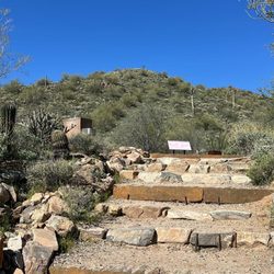
Love this trailhead by back gate of Scottsdale Mountain development. Never too crowded, you can either head towards flatter part to Jeep trail or do little more elevation towards Sunrise Peak trail. No restrooms at this location. read more


Easy trail. Just above difficulty of walking on a sidewalk or in the park. It's flat and slightly rocky on some parts but mostly level. Not very likely to roll and ankle or slip. But have to watch out for some cyclists as they barrel down the paths. Not a bad trail. A wash goes through the trail. Parts of the trail rims a neighborhood community. No shade on this trail so keep hydrated and bring sunblock. Okay views with somewhat elevated terrain to see skyline. Trails have signs well marked along the way. Pretty clean. Saw a few left-behind piles of dog feces on sides of trail but no trash For all age ranges from young to elderly. Has clean bathrooms. There are water amenities; fountains and bottle fill station. Info center with complimentary maps. Dog friendly. Has complimentary doggie doo bags. A doggie water fountain at the trailhead. There's an amphitheater near the trailhead. Plenty of paved parking at walking distance from entrance. read more


14 years ago
More info about Ringtail Trailhead
12282-12498 N 128th St
Scottsdale, AZ 85259
Directions
Hours
Outdoor Amenities
Ask the Community - Ringtail Trailhead


Ringtail Trailhead - hiking - Updated June 2026
Best of Scottsdale
People found Ringtail Trailhead by searching for…
Sunrise Hike in Scottsdale, Arizona
Paved Walking Trails in Scottsdale, Arizona
Easy Hikes in Scottsdale, Arizona
Sunrise View in Scottsdale, Arizona
Hiking Trails in Scottsdale, Arizona
Scenic View in Scottsdale, Arizona
Beautiful Views in Scottsdale, Arizona
Hiking Groups in Scottsdale, Arizona
Hikes With Dogs in Scottsdale, Arizona
Things to Do in Scottsdale, Arizona
Stroller Friendly Hikes in Scottsdale, Arizona
Dog Friendly Hiking Trails in Scottsdale, Arizona
Off Road Trails in Scottsdale, Arizona
Off Leash Dog Hiking Trails in Scottsdale, Arizona
Skyline View in Scottsdale, Arizona
Running Trails in Scottsdale, Arizona
Jogging Trails in Scottsdale, Arizona
Bike Paths in Scottsdale, Arizona
Night Hiking in Scottsdale, Arizona
Trending Searches in Scottsdale, AZ
Black Owned Nail Salons near Ringtail Trailhead
Boat Rental near Ringtail Trailhead
Cliff Jumping near Ringtail Trailhead
Creeks near Ringtail Trailhead
Day Trips near Ringtail Trailhead
Dog Friendly Trails near Ringtail Trailhead
Fireworks near Ringtail Trailhead
Fishing Spots near Ringtail Trailhead
Jet Ski Rental near Ringtail Trailhead
Kayak Rental near Ringtail Trailhead
Lakes & Ponds near Ringtail Trailhead
Outdoor Activities near Ringtail Trailhead
Places To Walk Around near Ringtail Trailhead
Public Pools near Ringtail Trailhead
Public Shower near Ringtail Trailhead
River Swimming near Ringtail Trailhead
Rock Quarry near Ringtail Trailhead
Scenic Night View near Ringtail Trailhead
Scenic Overlook near Ringtail Trailhead
Secluded Spots near Ringtail Trailhead
Soccer Store near Ringtail Trailhead
Splash Pad near Ringtail Trailhead
Strawberry Picking near Ringtail Trailhead
Sunrise View near Ringtail Trailhead
Swimming Holes near Ringtail Trailhead
Swimming Lakes near Ringtail Trailhead
Watch Sunset near Ringtail Trailhead
Browse Articles
Browse Nearby
BEST of Scottsdale, Arizona Coffee near Ringtail Trailhead
BEST of Scottsdale, Arizona Restaurants near Ringtail Trailhead
BEST of Scottsdale, Arizona Parks near Ringtail Trailhead
BEST of Scottsdale, Arizona Things to Do near Ringtail Trailhead
BEST of Scottsdale, Arizona Lakes near Ringtail Trailhead
BEST of Scottsdale, Arizona Breakfast near Ringtail Trailhead
Browse Brands
Related Searches in Scottsdale, AZ
Affordable Kayak Rental Services in Scottsdale, Arizona
Best Fishing Locations and Guides in Scottsdale, Arizona
Best Nature Trails for Hiking in Scottsdale, Arizona
Best Places for Horseback Riding in Scottsdale, Arizona
Best Waterfalls and Swimming Holes in Scottsdale, Arizona
Check Out Off Road Trails in Scottsdale, Arizona
Discover Dog Friendly Trails to Explore in Scottsdale, Arizona
Discover Scenic Mountain Bike Trails Near Scottsdale, Arizona
Discover Scenic Waterfall Spots in Scottsdale, Arizona
Discover Top Nature Parks to Visit in Scottsdale, Arizona
Discover Walking Parks in Scottsdale, Arizona Near You
Discover the Best Night Hike Trails in Scottsdale, Arizona
Discover the Best Running Track in Scottsdale, Arizona
Enjoy Camping Adventures Around Scottsdale, Arizona
Enjoy Exciting Mountain Biking Adventures in Scottsdale, Arizona
Enjoy Kayaking Adventures in Scottsdale, Arizona
Enjoy River Tubing Adventures in Scottsdale, Arizona
Enjoy Tent Camping Spots Around Scottsdale, Arizona
Enjoy a Beautiful Waterfall Hike in Scottsdale, Arizona
Enjoy the Best Walking Path in Scottsdale, Arizona
Enjoy the Best Walking Trails in Scottsdale, Arizona
Exciting Cliff Jumping Spots in Scottsdale, Arizona
Experience Thrilling White Water Rafting in Scottsdale, Arizona
Explore Beautiful Parks and Green Spaces in Scottsdale, Arizona
Explore Easy Hikes Perfect for All in Scottsdale, Arizona
Explore Fun Activities to Do in Scottsdale, Arizona
Explore Popular Campgrounds Near Scottsdale, Arizona
Explore the Best Beach Spots in Scottsdale, Arizona
Explore the Best Boating Spots in Scottsdale, Arizona
Explore the Best Trail Options in Scottsdale, Arizona
Family Friendly Hiking With Kids in Scottsdale, Arizona
Find Beautiful Views in Scottsdale, Arizona
Find Cozy Camping Cabins in Scottsdale, Arizona
Find the Best Parks for Picnics in Scottsdale, Arizona
Find the Best Scenic View Locations in Scottsdale, Arizona
Great Places to Walk in Scottsdale, Arizona
Hiking Trails With Waterfalls in Scottsdale, Arizona
Off Leash Dog Hiking Trails in Scottsdale, Arizona
Plan a Scenic Drive Route Near Scottsdale, Arizona
Popular Fishing Spots to Explore in Scottsdale, Arizona
Popular Outdoor Activities to Try in Scottsdale, Arizona
Popular Picnic Spots to Visit in Scottsdale, Arizona
Safe River Swimming Areas in Scottsdale, Arizona
Safe and Fun Parks for Kids in Scottsdale, Arizona
Top Climbing Spots and Gyms in Scottsdale, Arizona
Top Running Trails to Explore in Scottsdale, Arizona
Top Swimming Lakes to Enjoy in Scottsdale, Arizona
Top Swimming Spots and Pools in Scottsdale, Arizona