Granite Mountain Trailhead Photos


You might also consider
More like Granite Mountain Trailhead
Recommended Reviews - Granite Mountain Trailhead
Start your review...

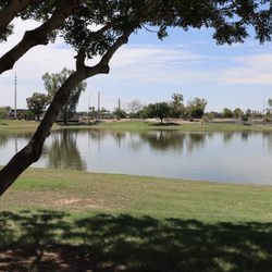
Reviews With Photos


When the weather is nice -- most weekends between September and May -- we hike either nearby Fraesfield or Granite Mountain Trail. The trailhead provides plenty of shade and clean bathrooms, but no water, so bring plenty of your own. I mean it, out of towners! And don't attempt it over 100. The trails are easy, but the sun is expert. As an aside to trainers: the trailhead is a gym, and there are pokestops throughout. Gotta catch 'em all! read more


9 months ago
Great trail lots of horse poop couple bikers but views are solid if your looking for a scenic little stroll. Restrooms are clean bring water there is not water on site. read more


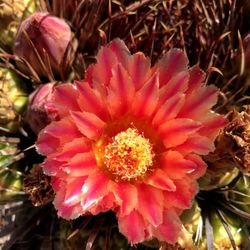
Did a combination hike. It was a loop about 3.6 miles round. It was the turpentine, black Hill, granite mountain and bootlegger Trail. I considered it an easy path. Pretty much flat except for a handful of spots. You get to see a lot of cacti and desert plants. We were able to see a few beautiful birds. I did see a few small animals along the way as well. Entrance and parking are free. It is a dog friendly path. They do have clean bathrooms at the beginning of the trail by the parking lot. We do have to share the path with bicyclist and those on horses. Everyone was pretty cordial to each other. Don't expect any shade, so if you go on a sunny hot day, take plenty of water, sunblock and a hat. read more


3 months ago
Not sure why I've never been to this trailhead. It's absolutely gorgeous ( March visit) There's plenty of trailhead parking and a restroom. There's many different trails you can follow. Be sure to check the trail map out before heading out. We saw lots of mountain bikers and other hikers. It is a good trail to also run. Everyone we encountered was nice, polite and courteous. Would highly recommend for children as well. Dogs were allowed on this trail. read more


6 months ago


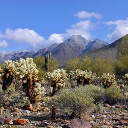
Granite mountain loop trail in north Scottsdale is a gorgeous winter or spring hike that takes you through a variety of microclimates, all on a relatively flat and wide trail. Do the ~6 miles trail counter clockwise from the entrance. It starts out in an area with a high density of soap-tree type yuccas, a bit unusual for Phoenix. Throughout there are mature and very healthy saguaros, many with over a dozen arms. Huge granite boulders are also throughput, though the best are in the first 2 miles of the trail. As you head up the gentle climb the yuccas give way to scrub Paloverde, plentiful pencil cholla, and more saguaros. The trail was surprisingly green even though we had a very dry winter. On the NE section, ocotillos come on the scene. The north portion is a bit dryer but still plentiful vegetation and as you hike along the west side you enter an area with acacia trees and grasses plus cholla and more saguaros. The trail is shared with horses and bikes and on a Friday in late February we ran into mostly bikes. Overall it was moderately trafficked. The trail will be gorgeous in a year that we have a wet spring bringing out the wild flowers. read more


6 years ago
Great new trail option, lots of bikers not too many hikers but amazing flora and scenery. Not much elevation so not a hard workout but great for dogs and daily hikes. Dog bags are provided and so are maps. New bathrooms though no running water. read more


3 years ago
I really enjoyed this trail. The scenery is full of a variety of different cacti and massive boulders. The train isn't difficult at all and it's well marked. Once you reach the peak, you'll enjoy beautiful Mountain View's that are well worth the steps. read more


More info about Granite Mountain Trailhead
31402 N 136th St
Scottsdale, AZ 85262
Directions
Hours
Outdoor Amenities
Ask the Community - Granite Mountain Trailhead
You might also consider


Granite Mountain Trailhead - hiking - Updated May 2026
Best of Scottsdale
People found Granite Mountain Trailhead by searching for…
Scenic View in Scottsdale, Arizona
Easy Hikes in Scottsdale, Arizona
Hiking Trails in Scottsdale, Arizona
Scenic Overlook in Scottsdale, Arizona
Running Trails in Scottsdale, Arizona
Dog Friendly Hiking Trails in Scottsdale, Arizona
Hiking With Kids in Scottsdale, Arizona
Things to Do in Scottsdale, Arizona
Walking Paths in Scottsdale, Arizona
Photo Spots in Scottsdale, Arizona
Hiking Groups in Scottsdale, Arizona
Hikes With Dogs in Scottsdale, Arizona
Walking Trails in Scottsdale, Arizona
Off Leash Dog Hiking Trails in Scottsdale, Arizona
Beautiful Views in Scottsdale, Arizona
Romantic Views in Scottsdale, Arizona
Off Road Trails in Scottsdale, Arizona
Waterfalls in Scottsdale, Arizona
Pokestops in Scottsdale, Arizona
Trending Searches in Scottsdale, AZ
Botanical Gardens near Granite Mountain Trailhead
Bounce House Rentals near Granite Mountain Trailhead
Campgrounds near Granite Mountain Trailhead
Cherry Picking near Granite Mountain Trailhead
Cliff Jumping near Granite Mountain Trailhead
Dog Friendly Things To Do near Granite Mountain Trailhead
Flower Fields near Granite Mountain Trailhead
Flower Shop near Granite Mountain Trailhead
Garage Sales near Granite Mountain Trailhead
Garden Center near Granite Mountain Trailhead
Hair near Granite Mountain Trailhead
Lakes & Ponds near Granite Mountain Trailhead
Nurseries & Gardening near Granite Mountain Trailhead
Outdoor Activities near Granite Mountain Trailhead
Outdoor Furniture Stores near Granite Mountain Trailhead
Parks near Granite Mountain Trailhead
Party Equipment Rentals near Granite Mountain Trailhead
Pedicure near Granite Mountain Trailhead
Photo Spots near Granite Mountain Trailhead
Pick Your Own Farms near Granite Mountain Trailhead
Picnic Areas near Granite Mountain Trailhead
Places To Take Pictures near Granite Mountain Trailhead
Rock Quarry near Granite Mountain Trailhead
Running Trails near Granite Mountain Trailhead
Strawberry Picking near Granite Mountain Trailhead
Sunrise View near Granite Mountain Trailhead
Swimming Holes near Granite Mountain Trailhead
Table And Chair Rentals near Granite Mountain Trailhead
Browse Articles
Browse Nearby
BEST of Scottsdale, Arizona Restaurants near Granite Mountain Trailhead
BEST of Scottsdale, Arizona Coffee near Granite Mountain Trailhead
BEST of Scottsdale, Arizona Things to Do near Granite Mountain Trailhead
BEST of Scottsdale, Arizona Breakfast near Granite Mountain Trailhead
BEST of Scottsdale, Arizona Horseback Riding near Granite Mountain Trailhead
BEST of Scottsdale, Arizona Hotels near Granite Mountain Trailhead
Browse Brands
Related Searches in Scottsdale, AZ
Affordable Kayak Rental Services in Scottsdale, Arizona
Best Fishing Locations and Guides in Scottsdale, Arizona
Best Nature Trails for Hiking in Scottsdale, Arizona
Best Places for Horseback Riding in Scottsdale, Arizona
Best Waterfalls and Swimming Holes in Scottsdale, Arizona
Check Out Off Road Trails in Scottsdale, Arizona
Discover Dog Friendly Trails to Explore in Scottsdale, Arizona
Discover Scenic Mountain Bike Trails Near Scottsdale, Arizona
Discover Scenic Waterfall Spots in Scottsdale, Arizona
Discover Top Nature Parks to Visit in Scottsdale, Arizona
Discover Walking Parks in Scottsdale, Arizona Near You
Discover the Best Night Hike Trails in Scottsdale, Arizona
Discover the Best Running Track in Scottsdale, Arizona
Enjoy Camping Adventures Around Scottsdale, Arizona
Enjoy Exciting Mountain Biking Adventures in Scottsdale, Arizona
Enjoy Kayaking Adventures in Scottsdale, Arizona
Enjoy River Tubing Adventures in Scottsdale, Arizona
Enjoy Tent Camping Spots Around Scottsdale, Arizona
Enjoy a Beautiful Waterfall Hike in Scottsdale, Arizona
Enjoy the Best Walking Path in Scottsdale, Arizona
Enjoy the Best Walking Trails in Scottsdale, Arizona
Exciting Cliff Jumping Spots in Scottsdale, Arizona
Experience Thrilling White Water Rafting in Scottsdale, Arizona
Explore Beautiful Parks and Green Spaces in Scottsdale, Arizona
Explore Easy Hikes Perfect for All in Scottsdale, Arizona
Explore Fun Activities to Do in Scottsdale, Arizona
Explore Popular Campgrounds Near Scottsdale, Arizona
Explore the Best Beach Spots in Scottsdale, Arizona
Explore the Best Boating Spots in Scottsdale, Arizona
Explore the Best Trail Options in Scottsdale, Arizona
Family Friendly Hiking With Kids in Scottsdale, Arizona
Find Beautiful Views in Scottsdale, Arizona
Find Cozy Camping Cabins in Scottsdale, Arizona
Find the Best Parks for Picnics in Scottsdale, Arizona
Find the Best Scenic View Locations in Scottsdale, Arizona
Great Places to Walk in Scottsdale, Arizona
Hiking Trails With Waterfalls in Scottsdale, Arizona
Off Leash Dog Hiking Trails in Scottsdale, Arizona
Plan a Scenic Drive Route Near Scottsdale, Arizona
Popular Fishing Spots to Explore in Scottsdale, Arizona
Popular Outdoor Activities to Try in Scottsdale, Arizona
Popular Picnic Spots to Visit in Scottsdale, Arizona
Safe River Swimming Areas in Scottsdale, Arizona
Safe and Fun Parks for Kids in Scottsdale, Arizona
Top Climbing Spots and Gyms in Scottsdale, Arizona
Top Running Trails to Explore in Scottsdale, Arizona
Top Swimming Lakes to Enjoy in Scottsdale, Arizona
Top Swimming Spots and Pools in Scottsdale, Arizona
People who viewed Granite Mountain Trailhead also viewed
Fraesfield Trailhead
7 reviews
McDowell Sonoran Preserve
169 reviews
Tom's Thumb Trailhead
145 reviews
Lost Dog Wash Trail
93 reviews
Pinnacle Peak Park
196 reviews
Sunrise Trailhead
35 reviews
Four Peaks Mountain Range
5 reviews
Ringtail Trailhead
3 reviews
Cave Creek Trail
3 reviews
Black Mountain Summit Trail
31 reviews