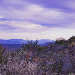
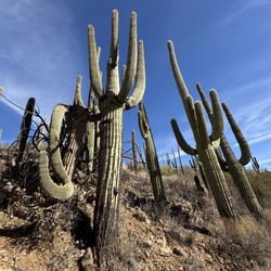
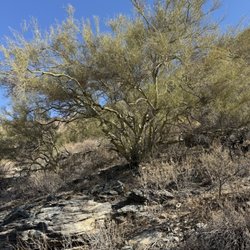
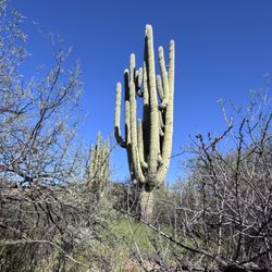
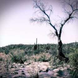
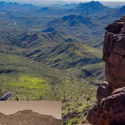
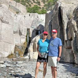
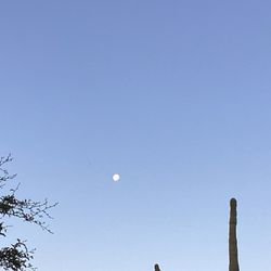
Black Mountain Summit Trail Photos


You might also consider
More like Black Mountain Summit Trail
Recommended Reviews - Black Mountain Summit Trail
Start your review...

Reviews With Photos

This is an awesome trail. Very challenging in the sense that it's quite steep but someone in decent shape can still probably get up and down in 2-3 hours. Very deceiving as you climb tho. I kept thinking I was close to the top but hadn't made it yet. Also, why do ppl give trails less than a 5 star review? It's a trail man, how's it going to improve?


Really loved Black Mountain trail. The hike is challenging, but don't get it twisted, it is not camelback. It's great in the fact that it's difficult but safe. No use of the hands are required. I didn't have any fearfulness of falling. The trail is well maintained and not very busy. I'd rank it in between camelback and Piestewa peak

This is a classic trail in the valley that is deceptively strenuous. I think total distance is just over a mile one way, but it doesn't let up with its steepness. I live in North Phoenix so this is close enough to me that it's not such a long drive, but also far enough away from downtown that it is not excessively crowded. There are a lot of parking options at the intersection of Military Rd, Mark Way, and N School House Rd. The trailhead itself is just a five minute walk up School House Rd. You'll usually see others coming or going so you shouldn't have much difficulty reaching it. The trail itself has a couple of false summit instances, but don't lose hope. As I mentioned the steepness may make it seem daunting at times, but overall the length is very short. Anyone in reasonable shape could make the summit in under an hour. I usually average around 30 minutes. At the summit you're rewarded with an American flag and awesome views. Spend some time and savor the scenery before making your descent.

2.2 mile hike with 1,100 ft in elevation gain. Provides beautiful views of North Phoenix/Scottsdale and Cave Creek. Trail is fairly well groomed and is never terribly busy. No restrictions (that I know of) on time of day, making this a great hike if you'd like to go before sunrise or after sunset. Be prepared for a generally steep climb for the entirety and climbing over larger rocks in some portions, as is common for most Phoenix hikes. Comparable to Echo Trail on Camelback which is 2.4 miles and 1,400 ft elevation gain.

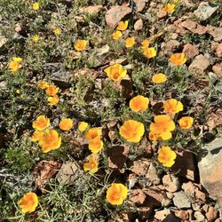
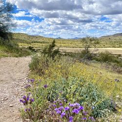
5 stars for what it is: a steep 1 mile climb (21% average grade vs Camelback which is 22%, for reference). I chose this over the more popular hike because the 1% challenge difference isn't worth the challenge of dealing with throngs of people and limited parking. I saw a handful of people and all were quite friendly, which to me means they're all regular hikers and added to the pleasure of this trail. You have to park a quarter mile before the trailhead and pass some houses to get to the start. You're never out of view of houses actually, but that's because this trail is in an urban area. Some people lower their rating because of this but... It's in an urban area. Besides, the houses are pretty cool. You can hear music from one of the restaurants in town all the way to the summit. If you like southern rock and country you'll enjoy it. BTW, there are several biker hangouts in town ... so you will also hear a lot of loud bikes. Definitely not a "backcountry" experience. Haha Lots of wildflowers, a few coyotes, sharp jagged rocks and 360° views made it a good short workout hike.


This trail is one very good reason to visit the Cave Creek area. It provides some of the best views of the Valley without being too far from Phoenix, it gives you a really good cardiovascular workout because the climb is moderately challenging, and you have truly breathtaking views from the slope to the summit. I did not encounter any really risky drop-offs from the sides of the trail, but the abundance of cacti and sharp-angled rocks will make you want to be careful nonetheless. The trailhead and parking area are right in the middle of the town of Cave Creek, which makes it easy find a cafe, restaurant, or bar to refresh yourself after completing the climb.

Awesome hike! One of my top favorites. The 360 degree views from the top are incredible and make it all worth the sweat. Not a very crowded trail. There's no warm-up, you go straight up until you hit the top and then straight back down. Very rocky and jagged. Some parts I couldn't tell where the trail was and had to follow people. There's 75yr olds that climb this mountain topless like its nothing, they put me to shame. I want to move to Cave Creek simply for the motivation that people over twice my age give me- WOW!


Any walker/hiker must now start very early to get their trail hike. The incline begins quickly and will get your heart beating within 15 minutes of walking. It is a steep incline until you hit the entrance. From there it is loose dirt with some portions being slight flat. However if you want to reach the summit, it's a good uphill climb. At least, coming back is all downhill and you have to dig in. Free street parking. Just be courteous to those who live nearby and off the trail. read more


2 years ago
How do you rate a hike like this?! 5 stars with alot of asterisks! My fiancé is the experienced hiker. Lover of trail runs, marathons, and completing the types of challenging hikes they make documentaries about, this hike albeit steep was a breeze. He ran a few miles to the trailhead, hiked the mountain, then ran back to the hotel three times during our stay. I, on the other hand am not a fan of early mornings or strenuous hikes but I do love a good challenge. In lieu of beating my time up Toms Thumb, I tackled Black Mountain solo, and let me tell you, if my 4'11", geriatric knee having, asthmatic, former athlete self can complete this hike, you can too! Yes, it's pretty dang steep. I wish someone would have warned me that instead of riding switchbacks, you are climbing straight up, gaining elevation very quickly, but it does make for a fun change of pace. Personally, it took me an hour up, and an hour down (so two hours total), and my partner made it up in 30 minutes, and down in around the same (so an hour total). Here are a few tips no matter your skill level: *bring water, a snack or two, sunscreen, sunshades, and considering how steep this bad boy is, wear hiking shoes with good grips. I hiked in October 2024, so I'm not sure if you'd need to modify for other times of the year. *know that although there are a good amount of shops if you make it to the Spanish Village, there aren't a ton of walkable roads in the surrounding town of carefree. In fact, there are a few residents that live on this mountain, and may encounter cars on your way up to the trailhead marker. *all trails is an amazing app to have handy for this and other solo hikes if you're going alone or would like to track your time/ensure you stay on the trail (it buzzed a few times to alert me that I was no longer on the trail...whoops) *the view is nice...even if you don't make it to the top, you're in for a visual treat! read more

 - Hiking Near Me - Cave Creek, Arizona")


This is one of my favorite hikes in town. It's about a 1.1 mile hike one way with a 1,197 foot elevation change. There's no parking at the start of the trail head. Parking is off School House road. There not a lot of parking but I've never had difficulties finding a spot. You have to walk up a paved road to get to the start of the hike. The trail is primitive and rocky. I just love how you have to concentrate with each step. I find the other hikers on this trail are always so friendly and polite. Always giving the right away to the people going up. You will experience a false peak but it's obvious when you reach the top. There's an American flag at the top on the mountain. The 360 degree views are incredible! I've hiked it r/t in 50 minutes when I'm in shape but have dragged it out to 1 hour 20 minutes before. Just take you time , bring some water and remember your hiking etiquette! read more


This is an awesome trail. Very challenging in the sense that it's quite steep but someone in decent shape can still probably get up and down in 2-3 hours. Very deceiving as you climb tho. I kept thinking I was close to the top but hadn't made it yet. Also, why do ppl give trails less than a 5 star review? It's a trail man, how's it going to improve? read more


6 years ago
Great hike from downtown Cave Creek. Get out early and bring water. Good news is "IF" you make it to the top and back down treat yourself to a refreshing beverage at Black Mountain Distillery or Cave Creek Coffee! Be careful and enjoy the views. read more


Really loved Black Mountain trail. The hike is challenging, but don't get it twisted, it is not camelback. It's great in the fact that it's difficult but safe. No use of the hands are required. I didn't have any fearfulness of falling. The trail is well maintained and not very busy. I'd rank it in between camelback and Piestewa peak read more

This is a classic trail in the valley that is deceptively strenuous. I think total distance is just over a mile one way, but it doesn't let up with its steepness. I live in North Phoenix so this is close enough to me that it's not such a long drive, but also far enough away from downtown that it is not excessively crowded. There are a lot of parking options at the intersection of Military Rd, Mark Way, and N School House Rd. The trailhead itself is just a five minute walk up School House Rd. You'll usually see others coming or going so you shouldn't have much difficulty reaching it. The trail itself has a couple of false summit instances, but don't lose hope. As I mentioned the steepness may make it seem daunting at times, but overall the length is very short. Anyone in reasonable shape could make the summit in under an hour. I usually average around 30 minutes. At the summit you're rewarded with an American flag and awesome views. Spend some time and savor the scenery before making your descent. read more


2.2 mile hike with 1,100 ft in elevation gain. Provides beautiful views of North Phoenix/Scottsdale and Cave Creek. Trail is fairly well groomed and is never terribly busy. No restrictions (that I know of) on time of day, making this a great hike if you'd like to go before sunrise or after sunset. Be prepared for a generally steep climb for the entirety and climbing over larger rocks in some portions, as is common for most Phoenix hikes. Comparable to Echo Trail on Camelback which is 2.4 miles and 1,400 ft elevation gain. read more


6 years ago
My husband and I enjoyed this hike on a Saturday morning. It's a challenging hike, but worth going all the way up. It's not a busy trail. There is not a parking lot at this trail. read more


7 years ago
5 stars for what it is: a steep 1 mile climb (21% average grade vs Camelback which is 22%, for reference). I chose this over the more popular hike because the 1% challenge difference isn't worth the challenge of dealing with throngs of people and limited parking. I saw a handful of people and all were quite friendly, which to me means they're all regular hikers and added to the pleasure of this trail. You have to park a quarter mile before the trailhead and pass some houses to get to the start. You're never out of view of houses actually, but that's because this trail is in an urban area. Some people lower their rating because of this but... It's in an urban area. Besides, the houses are pretty cool. You can hear music from one of the restaurants in town all the way to the summit. If you like southern rock and country you'll enjoy it. BTW, there are several biker hangouts in town ... so you will also hear a lot of loud bikes. Definitely not a "backcountry" experience. Haha Lots of wildflowers, a few coyotes, sharp jagged rocks and 360° views made it a good short workout hike. read more


7 years ago
Fun and moderate hike with amazon desert and sunset views. The day I did it the clouds were amazing. read more


This trail is one very good reason to visit the Cave Creek area. It provides some of the best views of the Valley without being too far from Phoenix, it gives you a really good cardiovascular workout because the climb is moderately challenging, and you have truly breathtaking views from the slope to the summit. I did not encounter any really risky drop-offs from the sides of the trail, but the abundance of cacti and sharp-angled rocks will make you want to be careful nonetheless. The trailhead and parking area are right in the middle of the town of Cave Creek, which makes it easy find a cafe, restaurant, or bar to refresh yourself after completing the climb. read more


8 years ago
6 years ago
Awesome hike! One of my top favorites. The 360 degree views from the top are incredible and make it all worth the sweat. Not a very crowded trail. There's no warm-up, you go straight up until you hit the top and then straight back down. Very rocky and jagged. Some parts I couldn't tell where the trail was and had to follow people. There's 75yr olds that climb this mountain topless like its nothing, they put me to shame. I want to move to Cave Creek simply for the motivation that people over twice my age give me- WOW! read more


7 years ago
11 years ago
What a view! Its a lot of work to get their but worth it. Round trip for most will be over an hour and close to 1.5. read more


15 years ago
This is a primitive that ascends about 1000 ft. with great views. It's all walking, but rocky and steep. It starts at the center (business center) of Cave Creek. Park at the crossing of Andora Wash and start up Schoolhouse Road. The trail gets steeper as you go up. Bear left where the road jogs west onto private property. It takes me about an hour up and 40 minutes down. (I'm pretty fit.) Best done in the cooler months. read more


10 years ago
8 years ago
14 years ago
11 years ago
11 years ago
12 years ago
10 years ago
13 years ago
13 years ago
More info about Black Mountain Summit Trail
Schoolhouse Rd
Cave Creek, AZ 85331
Directions
Hours
Outdoor Amenities
Ask the Community - Black Mountain Summit Trail
Review Highlights - Black Mountain Summit Trail
You might also consider


Why does Yelp recommend reviews?
Black Mountain Summit Trail - hiking - Updated July 2026
Best of Cave Creek
People found Black Mountain Summit Trail by searching for…
Scenic Overlook in Cave Creek, AZ
Watch Sunset in Cave Creek, AZ
Sunrise View in Cave Creek, AZ
Hiking Trails With Waterfalls in Cave Creek, AZ
Sunrise Hike in Cave Creek, AZ
Off Road Trails in Cave Creek, AZ
Paved Walking Trails in Cave Creek, AZ
Things to Do in Cave Creek, AZ
Lookout Points in Cave Creek, AZ
Fishing Spots in Cave Creek, AZ
Beautiful Views in Cave Creek, AZ
Running Trails in Cave Creek, AZ
Hiking With Kids in Cave Creek, AZ
Places to Walk in Cave Creek, AZ
Romantic Views in Cave Creek, AZ
Trending Searches in Cave Creek, AZ
Black Owned Nail Salons in Cave Creek, AZ
Cliff Jumping in Cave Creek, AZ
Dog Swimming in Cave Creek, AZ
Jet Ski Rental in Cave Creek, AZ
Kayak Rental in Cave Creek, AZ
Lakes & Ponds in Cave Creek, AZ
Off Road Trails in Cave Creek, AZ
Outdoor Activities in Cave Creek, AZ
Picnic Spots in Cave Creek, AZ
Places To Walk Around in Cave Creek, AZ
Public Pools in Cave Creek, AZ
Public Shower in Cave Creek, AZ
River Swimming in Cave Creek, AZ
River Tubing in Cave Creek, AZ
Running Trails in Cave Creek, AZ
Scenic Night View in Cave Creek, AZ
Scenic Overlook in Cave Creek, AZ
Soccer Store in Cave Creek, AZ
Sunrise View in Cave Creek, AZ
Swimming Holes in Cave Creek, AZ
Swimming Lakes in Cave Creek, AZ
U Pick Farms in Cave Creek, AZ
Browse Articles
Browse Nearby
BEST of Cave Creek, Arizona Restaurants near Black Mountain Summit Trail
BEST of Cave Creek, Arizona Parks near Black Mountain Summit Trail
BEST of Cave Creek, Arizona Coffee near Black Mountain Summit Trail
BEST of Cave Creek, Arizona Things to Do near Black Mountain Summit Trail
BEST of Cave Creek, Arizona Walking Trails near Black Mountain Summit Trail
BEST of Cave Creek, Arizona Breakfast near Black Mountain Summit Trail
BEST of Cave Creek, Arizona Hot Springs near Black Mountain Summit Trail
BEST of Cave Creek, Arizona Caves near Black Mountain Summit Trail
BEST of Cave Creek, Arizona Campgrounds near Black Mountain Summit Trail
Browse Brands
Related Searches in Cave Creek, AZ
Affordable Kayak Rental Services in Cave Creek, Arizona
Best Fishing Locations and Guides in Cave Creek, Arizona
Best Nature Trails for Hiking in Cave Creek, Arizona
Best Places for Horseback Riding in Cave Creek, Arizona
Best Waterfalls and Swimming Holes in Cave Creek, Arizona
Check Out Off Road Trails in Cave Creek, Arizona
Discover Dog Friendly Trails to Explore in Cave Creek, Arizona
Discover Scenic Waterfall Spots in Cave Creek, Arizona
Discover Top Scenic Spots to Visit in Cave Creek, Arizona
Discover a Hiking Trail in Cave Creek, Arizona
Discover the Best Night Hike Trails in Cave Creek, Arizona
Discover the Best Running Track in Cave Creek, Arizona
Enjoy Camping Adventures Around Cave Creek, Arizona
Enjoy Exciting Mountain Biking Adventures in Cave Creek, Arizona
Enjoy Kayaking Adventures in Cave Creek, Arizona
Enjoy River Tubing Adventures in Cave Creek, Arizona
Enjoy Tent Camping Spots Around Cave Creek, Arizona
Enjoy a Beautiful Waterfall Hike in Cave Creek, Arizona
Enjoy the Best Walking Path in Cave Creek, Arizona
Enjoy the Best Walking Trails in Cave Creek, Arizona
Exciting Cliff Jumping Spots in Cave Creek, Arizona
Experience Thrilling White Water Rafting in Cave Creek, Arizona
Explore Beautiful Parks and Green Spaces in Cave Creek, Arizona
Explore Easy Hikes Perfect for All in Cave Creek, Arizona
Explore Fun Activities to Do in Cave Creek, Arizona
Explore Popular Campgrounds Near Cave Creek, Arizona
Explore Popular Scenic Overlook Points in Cave Creek, Arizona
Explore the Best Beach Spots in Cave Creek, Arizona
Explore the Best Boating Spots in Cave Creek, Arizona
Family Friendly Hiking With Kids in Cave Creek, Arizona
Find Cozy Camping Cabins in Cave Creek, Arizona
Find Popular Ziplining Spots Around Cave Creek, Arizona
Find the Best Parks for Picnics in Cave Creek, Arizona
Find the Best Scenic View Locations in Cave Creek, Arizona
Great Places to Walk in Cave Creek, Arizona
Hiking Trails With Waterfalls in Cave Creek, Arizona
Off Leash Dog Hiking Trails in Cave Creek, Arizona
Plan a Scenic Drive Route Near Cave Creek, Arizona
Popular Fishing Spots to Explore in Cave Creek, Arizona
Popular Outdoor Activities to Try in Cave Creek, Arizona
Popular Picnic Spots to Visit in Cave Creek, Arizona
Safe River Swimming Areas in Cave Creek, Arizona
Safe and Fun Parks for Kids in Cave Creek, Arizona
Top Climbing Spots and Gyms in Cave Creek, Arizona
Top Paddleboarding Activities in Cave Creek, Arizona
Top Running Trails to Explore in Cave Creek, Arizona
Top Swimming Lakes to Enjoy in Cave Creek, Arizona
Top Swimming Spots and Pools in Cave Creek, Arizona
People who viewed Black Mountain Summit Trail also viewed
Gateway Desert Awareness Park
7 reviews
Tom's Thumb Trailhead
145 reviews
Lost Dog Wash Trail
94 reviews
Mountain View Park
2 reviews
Brown's Ranch Trailhead
49 reviews
Sunrise Trailhead
35 reviews
Four Peaks Mountain Range
5 reviews
Buffalo Ridge Park
23 reviews
Ringtail Trailhead
3 reviews
Spur Cross Ranch Conservation Area
51 reviews