Sonoran Preserve Photos


You might also consider
More like Sonoran Preserve
Recommended Reviews - Sonoran Preserve
Start your review...

Reviews With Photos

I'm rating this place as a non hiker, my car was getting fixed by a local auto repair shop and they told me about this place so I went to check it out myself. It's about a 5 minute drive from my place in Deer Valley. I've been here about a dozen times since I've learned about this place. I bring my dog every time and let him go exploring in the area without his leash. Make sure you DONT do this as there are signs posted that tell you to always have your pets on a leash. Please respect the posted signs guys. There are trails here but I don't come here for that. This is more for my dog to roam the area and pretend he's a hunting dog. I won't post any pics of my dog to protect his identity since he doesn't comply with the pets remain on leashes rule. I warned my dog but he just doesn't listen to me. I love him anyway. There are 4 separated rows of parking stalls, about 13 spaces each row. This is open non covered parking so your car will bake in the sun. There is also a separate staging area for a horse trailer parking and looks big enough to even park your RV here with no problem. There is a small building that houses a men's and ladies restroom in the middle of the parking lot. A filtered drinking water fountain to fill up your water flask is available here and the water is cold, just remember to stock up on ice in your flask. Outside of these restrooms is a small shaded concrete bench area that you can just catch a breather under the scorching sun. It's shaded because the roof of the restroom extends to cover the bench. There are 2 of these concrete benches. They remain cool to sit on despite being 110 degrees in the sun. That's all I got, maybe I'll go on a hike one of these days at this place but until then I'll just bring my rebel dog who refuses to be leashed up although the signs are posted here. If he gets a ticket from the park rangers maybe that will teach him a lesson. I always do my best to be factual in my reviews guys so let's not spill the beans about Doog ok? Doog is my dogs name. It's sounds like Doug but it's actually Doog. Like the word Duke but with the G sound at the end.
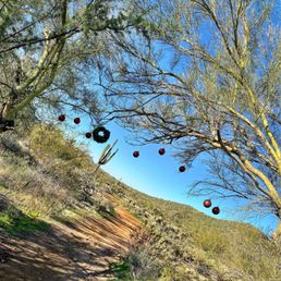
We love heading to this area for easy hikes. Nothing is too strenuous here. Some elevation gain on a few hikes, but slow and steady to get there. There are restrooms at the main parking area along with a trail map of the area. If you go early you can usually see the hot air balloons take off close by. Last year one of the trails was decorated for the holidays. (See attached photos!) Be sure to bring enough water and keep your dogs at home if it is over 100 degrees!

A family-friendly trail system in the middle of civilization. This is another great hiking experience for people visiting Phoenix for a few days. It's not difficult and there are many great picture opportunities. There are three parking lots that you can start your hike from (Desert Vista, Desert Hills and Apache Wash). We chose the southern lot (dessert vista) which is located in the middle of a planned housing community. Trails are clearly marked but I do suggest you take a picture of the preserve map before you hike. Bathrooms and filtered water fountains are located in each parking lot. We hiked in December and it was very nice temperature wise..


You just have to appreciate the beauty of the Arizona sunsets when living in the desert. The sky glows in so many different colors. Absolutely stunning! This is another great park to explore nature and the variety of cacti. All the hikers are so friendly. I can't wait to return to explore the other trails. There are restrooms here next to the parking lot.


While in Arizona, we spent a lot of time hiking. Toward the end of our trip, we wanted a longer-ish hike but nothing that was going to take all day. After looking around, we stumbled upon the Sonoran Preserve. Another perk is that this preserve was about 30 minutes from where we were staying. There were a few that we wanted to do that would've taken us some time to get to. If you check out the website for this preserve, you'll notice that it has numerous trails ranging in difficulty. The 4.5-mile trip that we planned quickly turned into nearly 6 miles(if not longer). We decided to make our own loop out of the Sidewinder and Ocotillo trails. From the small mountains on this trail, you can get a great view of a highway to your south as well as the immediate desert that surrounds you. This area is more of a workout trail in my opinion. You won't get those breathtaking views or the elevation that you'll get elsewhere. The loop that we were on was fun. These trails do provide a great desert experience without being too far out of town. It's hot. There's limited shade. It's rocky and sandy. There are also plenty of plants and cactuses to observe as you walk along the trails. We went mid-afternoon on a Saturday and it wasn't crowded at all. We saw people but nothing crazy. One thing to note would be the difficulty of the trails. On the website, the Sidewinder trail was listed as being moderate while the Ocotillo trail was listed as being easy. We were only on 2 miles(of 7) of the Sidewinder trail and it was much easier than the "easy" Ocotillo trail. It probably didn't help that our Ocotillo walk was mostly climbing elevation instead of all downhill at first. With that being said, make sure to take plenty of water with you... you'll need it. Also, give yourself more time than you think you'll need. While this was the last place we hiked during our visit, I wish this would've been the first place we went. It is a great introduction to the landscape without being a strenuous climb up Camelback or a crowded walk up South Mountain.

This fun hiking destination is tucked away behind Norterra at approximately Jomax and 19th Ave. it's got ample parking, including for horse trailers, bathrooms and water access, and is nearby the Fireside Community Center which offers a gym and splash pad for the kiddos (for some $$$). This area is becoming more popular and attractive, as I've noticed more visitors on the trails, which there are several to choose from, including two loops and one out-and-back to Dixie Mountain.

The preserve is divided into 3 trailheads: Desert Vista, Desert Hills, and Apache Wash. All 3 provide great hiking paths and beautiful views of the North Phoenix desert. I took my German Shepherd in early April, and it was a little warm, so make sure to take lots of water! The preserve is fairly large, so I recommend downloading the Avem app, it will help you find each trailhead, restrooms, and drinking fountains, and even gives you the option to view the Phoenix Sonoran Preserve map. Have fun out there and stay safe!
 have I seen a snake skeleton so intact in its naturally setting)")
This area is marked as "Sonoran Preserve" and it's the section north of Carefree Highway. There is a trailhead here and convenient street parking - the preserve is open sunrise to sunset. (There's also "Sonoran Preserve" south of Carefree Highway that has a dedicated parking lot. http://www.yelp.com/biz/sonoran-preserve-phoenix-2 ) I hike this side when I want a mix of trail/sidewalk. From the map link I provide at bottom, looks like this is called "Tramonto Trail" though it's not clearly marked on site. You can hike along the base of this summit and walk back along the street, more or less creating your own loop. There's also a moderate difficulty hike to the summit. (Not shown on map). (Nothing like Camelback etc but loose gravel and no man made "help" renders it a little more than "easy.") Nice for walk/jog but likely boring on a bike. Word of the day: hydrate! Complete trails maps can be found: https://www.phoenix.gov/parkssite/Documents/095100.pdf

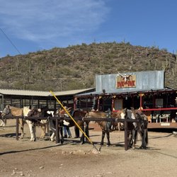
Sonoran Preserve, or as I like to call it, Sonoran Heaven. I've been coming to this trailhead to mountain bike for a couple of years now (didn't know you could check in, I could be the Duke!) We usually come every Saturday morning. The guys ride and our wives usually run the trails. Whether you're running or riding, these trails are fantastic! This is just a wonderful example of our tax dollars being put to excellent use. The trails are perfect for intermediate riders. Beginners will find them a little taxing but not un-doable. The trail takes off like a steep roller coaster right out of the gate. You might think, this is crazy (and it kind of is) but it really is one of the most challenging parts of the trail). The trails are fast and fun, lots of rollers and hair pin corners. I clip-in and very rarely unclip on these trails. There are a couple of areas it's wise to unclip but by and large, if you're decent on a bike, you won't need to unclip. (I ride a 29er) There are at least a dozen different trails and routes you can take, check the trailhead map for information or go online to the Phoenix Parks website. There are no bathrooms or water here. The Apache Wash trailhead just opened north of this ride, on Dove Valley Road. This is a fantastic addition to the Sonoran trail system. Bathrooms but no potable water. Nice equestrian unload area, parking for at least 200 cars (it seems like) and some extremely fun trails. The trails are roughly the same intensity as the ones above although you have a choice of taking the Ocotillo trail through the valley floor up to Carefree highway. This trail is a fun, fast ride through the desert whereas if you opt for the Sidewinder trail, you'll have a number of ridgelines to climb. It's all fun, just depends on what you're in the mood for. Hope to see you out there!

My friend and I hiked the south area trail 'Dixie Loop Trail' after reading it was a great place to see wildflowers in the spring in Phoenix Magazine (Dec 2014 issue). The trail was easy to get to, about 8min drive east off I-17. The trail is 3.8 miles and was beautiful. We kept a nice stroll and finished just over an hour and a half I think. Nice path to follow and much of the way we were able to walk side by side to keep up our conversation. A few steeper parts to get the heart rate up but it's still in the realm of what I would call an easy hike for someone moderately active. I enjoyed seeing all of the beautiful mountains and cactus but I was a bit disappointed that there weren't more wildflowers. There were some but most were so tiny, I wouldn't consider it a place to go for that reason only. Regardless, I still enjoyed it a lot and thought it was beautiful! There were only a few people so it made it seem like we had the place to ourselves and there were lots of interesting rocks to see. Plenty of parking and post workout lunch was only a 5 minute drive away. I would definitely come back here and check out other trails! You can find the map of all the trails here... https://www.phoenix.gov/parkssite/Documents/095100.pdf

It is in this preserve that you can experience the best Sonoran Desert scenery within the boundaries of the City of Phoenix. It is located at the extreme north end of the city, easily accessed through Sonoran Desert Drive from Cave Creek Road; or, take I-17 North to the Dove Valley Road Exit; Dove Valley road eventually becomes Sonoran Desert drive. Amenities are limited, which is not really an inconvenience (just remember to bring your own water!) and that fact also helps keep the scenery relatively unspoiled. From Sonoran Desert Drive, take the entrance to the Apache Wash Trailhead area; there will be ample parking spaces, as well as restrooms and a ramada for picnicking. The Preserve has trails well suited for hiking and biking, and in the areas near Sonoran Drive there are paved lanes for those who want a smoother ride on their bikes - or even push scooters, if you have those.

5 months ago


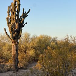
Not the most breathtaking views but it was a picture perfect day for a hike, and I wanted to see saguaro cacti. Some of the cacti were in the upwards of 30 feet tall. They look like stick figures with arms raised toward the sun in the fields. I took the four mile D trail "Over the Mountain Loop." It does not matter which direction if you are completing the entire trail, but I would go with the "start" direction if you only want to do part of the trail as it heads toward the side of the mountain with a better view. Multiple signs with mile count and QR code. Even though it was only 60 degrees, it was warm in the sun with a gentle breeze. Got to say hello to a horned owl nested in a cactus umbra. I would not have seen it except a fellow hiker who visits every year told me to look over the fence. Not a large parking lot and not any nearby alternatives, so be patient. A ranger was cutting off traffic from the trailer only parking, and she was recording license plates. read more


Waaaaaaaaay better than Thunderbird. Granted, today is Friday and not a Saturday but I didn't have to deal with a bunch of douchebags. The very few people I did encounter were courteous and actually knew what 'trail etiquette' is - it was such a joy to hike here! Plenty of ample parking. Trails are well marked, but since it was my first time hiking here - I still downloaded the gpx track from AllTrails to my Garmin. Didn't see much for wildlife this morning, but the views were spectacular. I did (3) different little summits. My Garmin and Strava says I did 13.4 miles and just a hair under 2,500 ft. of climbing. Highly recommended! Nice to know this place is so close to us here in the northwest part of the Valley! Enjoy your weekend, everyone! read more


I'm rating this place as a non hiker, my car was getting fixed by a local auto repair shop and they told me about this place so I went to check it out myself. It's about a 5 minute drive from my place in Deer Valley. I've been here about a dozen times since I've learned about this place. I bring my dog every time and let him go exploring in the area without his leash. Make sure you DONT do this as there are signs posted that tell you to always have your pets on a leash. Please respect the posted signs guys. There are trails here but I don't come here for that. This is more for my dog to roam the area and pretend he's a hunting dog. I won't post any pics of my dog to protect his identity since he doesn't comply with the pets remain on leashes rule. I warned my dog but he just doesn't listen to me. I love him anyway. There are 4 separated rows of parking stalls, about 13 spaces each row. This is open non covered parking so your car will bake in the sun. There is also a separate staging area for a horse trailer parking and looks big enough to even park your RV here with no problem. There is a small building that houses a men's and ladies restroom in the middle of the parking lot. A filtered drinking water fountain to fill up your water flask is available here and the water is cold, just remember to stock up on ice in your flask. Outside of these restrooms is a small shaded concrete bench area that you can just catch a breather under the scorching sun. It's shaded because the roof of the restroom extends to cover the bench. There are 2 of these concrete benches. They remain cool to sit on despite being 110 degrees in the sun. That's all I got, maybe I'll go on a hike one of these days at this place but until then I'll just bring my rebel dog who refuses to be leashed up although the signs are posted here. If he gets a ticket from the park rangers maybe that will teach him a lesson. I always do my best to be factual in my reviews guys so let's not spill the beans about Doog ok? Doog is my dogs name. It's sounds like Doug but it's actually Doog. Like the word Duke but with the G sound at the end. read more


We love heading to this area for easy hikes. Nothing is too strenuous here. Some elevation gain on a few hikes, but slow and steady to get there. There are restrooms at the main parking area along with a trail map of the area. If you go early you can usually see the hot air balloons take off close by. Last year one of the trails was decorated for the holidays. (See attached photos!) Be sure to bring enough water and keep your dogs at home if it is over 100 degrees! read more


A family-friendly trail system in the middle of civilization. This is another great hiking experience for people visiting Phoenix for a few days. It's not difficult and there are many great picture opportunities. There are three parking lots that you can start your hike from (Desert Vista, Desert Hills and Apache Wash). We chose the southern lot (dessert vista) which is located in the middle of a planned housing community. Trails are clearly marked but I do suggest you take a picture of the preserve map before you hike. Bathrooms and filtered water fountains are located in each parking lot. We hiked in December and it was very nice temperature wise.. read more


4 years ago
Love love this hike! Its easy ! You have a few options on which way you will go. We decided to just go to the left and up to get some views. I was pleasantly surprised the trail we took was a great one. Little up hill and incline. Its peaceful out here during the day that is. read more


You just have to appreciate the beauty of the Arizona sunsets when living in the desert. The sky glows in so many different colors. Absolutely stunning! This is another great park to explore nature and the variety of cacti. All the hikers are so friendly. I can't wait to return to explore the other trails. There are restrooms here next to the parking lot. read more


3 years ago
Beautiful hiking trails and views of the desert sunrises & sunsets. Wildflowers, cactus and wildlife. read more


While in Arizona, we spent a lot of time hiking. Toward the end of our trip, we wanted a longer-ish hike but nothing that was going to take all day. After looking around, we stumbled upon the Sonoran Preserve. Another perk is that this preserve was about 30 minutes from where we were staying. There were a few that we wanted to do that would've taken us some time to get to. If you check out the website for this preserve, you'll notice that it has numerous trails ranging in difficulty. The 4.5-mile trip that we planned quickly turned into nearly 6 miles(if not longer). We decided to make our own loop out of the Sidewinder and Ocotillo trails. From the small mountains on this trail, you can get a great view of a highway to your south as well as the immediate desert that surrounds you. This area is more of a workout trail in my opinion. You won't get those breathtaking views or the elevation that you'll get elsewhere. The loop that we were on was fun. These trails do provide a great desert experience without being too far out of town. It's hot. There's limited shade. It's rocky and sandy. There are also plenty of plants and cactuses to observe as you walk along the trails. We went mid-afternoon on a Saturday and it wasn't crowded at all. We saw people but nothing crazy. One thing to note would be the difficulty of the trails. On the website, the Sidewinder trail was listed as being moderate while the Ocotillo trail was listed as being easy. We were only on 2 miles(of 7) of the Sidewinder trail and it was much easier than the "easy" Ocotillo trail. It probably didn't help that our Ocotillo walk was mostly climbing elevation instead of all downhill at first. With that being said, make sure to take plenty of water with you... you'll need it. Also, give yourself more time than you think you'll need. While this was the last place we hiked during our visit, I wish this would've been the first place we went. It is a great introduction to the landscape without being a strenuous climb up Camelback or a crowded walk up South Mountain. read more


This fun hiking destination is tucked away behind Norterra at approximately Jomax and 19th Ave. it's got ample parking, including for horse trailers, bathrooms and water access, and is nearby the Fireside Community Center which offers a gym and splash pad for the kiddos (for some $$$). This area is becoming more popular and attractive, as I've noticed more visitors on the trails, which there are several to choose from, including two loops and one out-and-back to Dixie Mountain. read more


6 years ago
The preserve is divided into 3 trailheads: Desert Vista, Desert Hills, and Apache Wash. All 3 provide great hiking paths and beautiful views of the North Phoenix desert. I took my German Shepherd in early April, and it was a little warm, so make sure to take lots of water! The preserve is fairly large, so I recommend downloading the Avem app, it will help you find each trailhead, restrooms, and drinking fountains, and even gives you the option to view the Phoenix Sonoran Preserve map. Have fun out there and stay safe! read more

This area is marked as "Sonoran Preserve" and it's the section north of Carefree Highway. There is a trailhead here and convenient street parking - the preserve is open sunrise to sunset. (There's also "Sonoran Preserve" south of Carefree Highway that has a dedicated parking lot. http://www.yelp.com/biz/sonoran-preserve-phoenix-2 ) I hike this side when I want a mix of trail/sidewalk. From the map link I provide at bottom, looks like this is called "Tramonto Trail" though it's not clearly marked on site. You can hike along the base of this summit and walk back along the street, more or less creating your own loop. There's also a moderate difficulty hike to the summit. (Not shown on map). (Nothing like Camelback etc but loose gravel and no man made "help" renders it a little more than "easy.") Nice for walk/jog but likely boring on a bike. Word of the day: hydrate! Complete trails maps can be found: https://www.phoenix.gov/parkssite/Documents/095100.pdf read more
 have I seen a snake skeleton so intact in its naturally setting) - Hiking Near Me - Phoenix, Arizona")
Sonoran Preserve, or as I like to call it, Sonoran Heaven. I've been coming to this trailhead to mountain bike for a couple of years now (didn't know you could check in, I could be the Duke!) We usually come every Saturday morning. The guys ride and our wives usually run the trails. Whether you're running or riding, these trails are fantastic! This is just a wonderful example of our tax dollars being put to excellent use. The trails are perfect for intermediate riders. Beginners will find them a little taxing but not un-doable. The trail takes off like a steep roller coaster right out of the gate. You might think, this is crazy (and it kind of is) but it really is one of the most challenging parts of the trail). The trails are fast and fun, lots of rollers and hair pin corners. I clip-in and very rarely unclip on these trails. There are a couple of areas it's wise to unclip but by and large, if you're decent on a bike, you won't need to unclip. (I ride a 29er) There are at least a dozen different trails and routes you can take, check the trailhead map for information or go online to the Phoenix Parks website. There are no bathrooms or water here. The Apache Wash trailhead just opened north of this ride, on Dove Valley Road. This is a fantastic addition to the Sonoran trail system. Bathrooms but no potable water. Nice equestrian unload area, parking for at least 200 cars (it seems like) and some extremely fun trails. The trails are roughly the same intensity as the ones above although you have a choice of taking the Ocotillo trail through the valley floor up to Carefree highway. This trail is a fun, fast ride through the desert whereas if you opt for the Sidewinder trail, you'll have a number of ridgelines to climb. It's all fun, just depends on what you're in the mood for. Hope to see you out there! read more

My friend and I hiked the south area trail 'Dixie Loop Trail' after reading it was a great place to see wildflowers in the spring in Phoenix Magazine (Dec 2014 issue). The trail was easy to get to, about 8min drive east off I-17. The trail is 3.8 miles and was beautiful. We kept a nice stroll and finished just over an hour and a half I think. Nice path to follow and much of the way we were able to walk side by side to keep up our conversation. A few steeper parts to get the heart rate up but it's still in the realm of what I would call an easy hike for someone moderately active. I enjoyed seeing all of the beautiful mountains and cactus but I was a bit disappointed that there weren't more wildflowers. There were some but most were so tiny, I wouldn't consider it a place to go for that reason only. Regardless, I still enjoyed it a lot and thought it was beautiful! There were only a few people so it made it seem like we had the place to ourselves and there were lots of interesting rocks to see. Plenty of parking and post workout lunch was only a 5 minute drive away. I would definitely come back here and check out other trails! You can find the map of all the trails here... https://www.phoenix.gov/parkssite/Documents/095100.pdf read more


It is in this preserve that you can experience the best Sonoran Desert scenery within the boundaries of the City of Phoenix. It is located at the extreme north end of the city, easily accessed through Sonoran Desert Drive from Cave Creek Road; or, take I-17 North to the Dove Valley Road Exit; Dove Valley road eventually becomes Sonoran Desert drive. Amenities are limited, which is not really an inconvenience (just remember to bring your own water!) and that fact also helps keep the scenery relatively unspoiled. From Sonoran Desert Drive, take the entrance to the Apache Wash Trailhead area; there will be ample parking spaces, as well as restrooms and a ramada for picnicking. The Preserve has trails well suited for hiking and biking, and in the areas near Sonoran Drive there are paved lanes for those who want a smoother ride on their bikes - or even push scooters, if you have those. read more


7 years ago
This is first time I've hike this area.....absolutely beautiful! I admire the Scottsdale residents for the forethought to save this special area! read more


9 years ago
Beautiful easy going hiking loved my experience! Definitely will go earlier next spring! The scenery is amazing so peaceful! read more

12 years ago


11 years ago
7 years ago
12 years ago
10 years ago
12 years ago
11 years ago
12 years ago
11 years ago
11 years ago
11 years ago
11 years ago
9 years ago
More info about Sonoran Preserve
1900 W Desert Vista Trl
Phoenix, AZ 85085
Directions
Visit Website
https://www.phoenix.gov/parks/trails/locations/sonoran-preserve
Hours
Payment methods
Outdoor Amenities
Sonoran Preserve Reviews in Other Languages
Ask the Community - Sonoran Preserve
Is there an entrance or parking fee? If yes, how much?
No, there is no entrance or parking fee. The Desert Hills and Apache Wash trailheads have plenty of parking, but the lot at Desert Vista trailhead is pretty small. However, Desert Vista trailhead is usually the least busy. All 3 trailheads have… Read more
Review Highlights - Sonoran Preserve
You might also consider


Why does Yelp recommend reviews?
Sonoran Preserve - hiking - Updated June 2026
Best of Phoenix
People found Sonoran Preserve by searching for…
Scenic Drive in Phoenix, Arizona
Sunset View in Phoenix, Arizona
Splash Pad in Phoenix, Arizona
Places to Take Pictures in Phoenix, Arizona
Paved Walking Trails in Phoenix, Arizona
Scenic View in Phoenix, Arizona
Hiking Trails in Phoenix, Arizona
Flower Field in Phoenix, Arizona
Sunrise Hike in Phoenix, Arizona
Watch Sunset in Phoenix, Arizona
Things to Do in Phoenix, Arizona
Photo Spots in Phoenix, Arizona
Running Trails in Phoenix, Arizona
Off Road Trails in Phoenix, Arizona
Attractions in Phoenix, Arizona
Lookout Points in Phoenix, Arizona
Hiking With Kids in Phoenix, Arizona
Easy Hikes in Phoenix, Arizona
Scenic Overlook in Phoenix, Arizona
Equestrian Center in Phoenix, Arizona
Trending Searches in Phoenix, AZ
Black Owned Nail Salons near Sonoran Preserve
Boat Rental near Sonoran Preserve
Cliff Jumping near Sonoran Preserve
Day Trips near Sonoran Preserve
Dog Friendly Things To Do near Sonoran Preserve
Dog Friendly Trails near Sonoran Preserve
Easy Hikes near Sonoran Preserve
Fishing Spots near Sonoran Preserve
Jet Ski Rental near Sonoran Preserve
Kayak Rental near Sonoran Preserve
Lakes & Ponds near Sonoran Preserve
Off Road Trails near Sonoran Preserve
Outdoor Activities near Sonoran Preserve
Parks For Picnics near Sonoran Preserve
Pick Your Own Farms near Sonoran Preserve
Picnic Spots near Sonoran Preserve
Places To Walk Around near Sonoran Preserve
Public Shower near Sonoran Preserve
River Swimming near Sonoran Preserve
Rock Quarry near Sonoran Preserve
Scenic Night View near Sonoran Preserve
Scenic Overlook near Sonoran Preserve
Secluded Spots near Sonoran Preserve
Soccer Store near Sonoran Preserve
Splash Pad near Sonoran Preserve
Star Gazing near Sonoran Preserve
Strawberry Picking near Sonoran Preserve
Sunrise View near Sonoran Preserve
Swimming Holes near Sonoran Preserve
Swimming Lakes near Sonoran Preserve
Watch Sunset near Sonoran Preserve
Browse Nearby
Browse Brands
Related Searches in Phoenix, AZ
Affordable Bike Repair Services in Phoenix, Arizona
Affordable Bike Tune Up Services in Phoenix, Arizona
Affordable Horse Boarding Services in Phoenix, Arizona
Affordable Jet Ski Rental Options in Phoenix, Arizona
Affordable Kayak Rental Services in Phoenix, Arizona
Affordable Mobile Bike Repair in Phoenix, Arizona
Affordable Pony Rental Services Available in Phoenix, Arizona
Affordable Road Bike Rental in Phoenix, Arizona
Best Dog Hiking Trails Around Phoenix, Arizona
Best Electric Bike Rental Services in Phoenix, Arizona
Best Fishing Locations and Guides in Phoenix, Arizona
Best Fun Things to Do in Phoenix, Arizona
Best Nature Trails for Hiking in Phoenix, Arizona
Best Places for Horseback Riding in Phoenix, Arizona
Best Places to Sell Used Bike in Phoenix, Arizona
Best Used Bikes for Sale Near Phoenix, Arizona
Best Waterfalls and Swimming Holes in Phoenix, Arizona
Book English Riding Lessons Near You in Phoenix, Arizona
Check Out Off Road Trails in Phoenix, Arizona
Discover Dog Friendly Trails to Explore in Phoenix, Arizona
Discover Effective Equine Therapy Options in Phoenix, Arizona
Discover Equestrian Centers Around Phoenix, Arizona
Discover Fun Activities to Do in Phoenix, Arizona
Discover Horseback Riding Tours in Phoenix, Arizona
Discover Kid Friendly Hiking Trails in Phoenix, Arizona
Discover Popular Bike Tours in Phoenix, Arizona
Discover Scenic Bike Paths in Phoenix, Arizona
Discover Scenic Hiking Trails in Phoenix, Arizona
Discover Scenic Mountain Bike Trails Near Phoenix, Arizona
Discover Scenic Waterfall Spots in Phoenix, Arizona
Discover Top Nature Parks to Visit in Phoenix, Arizona
Discover Top-Rated Dude Ranch Experiences in Phoenix, Arizona
Discover Walking Parks in Phoenix, Arizona Near You
Discover the Best Night Hike Trails in Phoenix, Arizona
Discover the Best Running Track in Phoenix, Arizona
Dog-Friendly Hikes With Dogs in Phoenix, Arizona
Enjoy Camping Adventures Around Phoenix, Arizona
Enjoy Exciting Mountain Biking Adventures in Phoenix, Arizona
Enjoy Hiking Adventures in Phoenix, Arizona
Enjoy Horseback Riding on Beach in Phoenix, Arizona
Enjoy Kayaking Adventures in Phoenix, Arizona
Enjoy Relaxing Goat Yoga Classes in Phoenix, Arizona
Enjoy Stables and Horse Riding Experiences in Phoenix, Arizona
Enjoy Tent Camping Spots Around Phoenix, Arizona
Enjoy Thrilling Atv Riding Experiences in Phoenix, Arizona
Enjoy a Beautiful Waterfall Hike in Phoenix, Arizona
Enjoy the Best Tubing Experiences in Phoenix, Arizona
Enjoy the Best Walking Path in Phoenix, Arizona
Browse Articles
People who viewed Sonoran Preserve also viewed
Shaw Butte Recreation Area
28 reviews
Spur Cross Ranch Conservation Area
51 reviews
Phoenix Mountain Preserve
67 reviews
Echo Canyon Trail
36 reviews
Tom's Thumb Trailhead
145 reviews
Murphy's Bridle Path
13 reviews
Spur Cross Ranch Conservation Area
4 reviews
Reach 11 Recreation Area
19 reviews
The Arizona Canal
19 reviews
Tonto National Forest
4 reviews