Echo Canyon Trail Photos


You might also consider
More like Echo Canyon Trail
Recommended Reviews - Echo Canyon Trail
Start your review...

Reviews With Photos

Need to know: -limited parking, you may need to keep circling around. Carpool if possible. This is a popular trail. -HAVE YOUR HANDS FREE: bring hydration backpack or backpack to store water bottle. Gloves optional. -sturdy, grippy shoes -good attitude! Hike for the accomplishment of getting to the top, because honestly the view at the summit was okay. Every Phoenix Mountain View just looks like Google maps. But the pride of getting up there is worth it. I hated hiking and don't do it much, but I guess this trail made me like it. It's the hardest I've been on so far. This was my first hike of the year (went in November) and after this trail, I decided to keep hiking more. If you can do Camelback you can do most of them all.

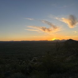
One of my favorite hikes in Phoenix. The echo canyon trail is up the west side of Camelback so it's in the shade on the way up in the morning. The Cholla trail is on the east side so it's in straight sun the whole morning. Echo is overall slightly more difficult but I prefer it's variety. Echo has a nice parking lot that fills up by 8 on the weekends. This hike really works your quads as there are a lot of step ups, steep inclines. If you have sensitive knees coming back down is going to be hard. The cooler the weather the better the hike. I recommend starting your hike by 8am. If you go after the rain you can get some beautiful cloud pictures and smell the desert rain. If you want a "semi regular" hike just go to marker 13 past the two pole rock climbs and go back down and skip the rock scrambles. You start with an uphill trail that then gets to the first plateau and then you go up a series of steep wooden stairs. Then you come to your first rock climb with pole assistance. A brief plateau then your second pole rock climb. That's it for the poles now you are on to rock scrambles for the rest of the way. You go through a brief plateau and then you encounter your first rock scramble. Another small plateau and then you have the very long rock scramble that will get your heart racing if it isn't yet. At the very top the rock scrambling finally gives way to a rocky trail and then you are at the top. Honestly my favorite views are on the way up rather than at the top so make sure to stop and grab some pics. 2.5 hr hike.

If you like to hike when you travel, I highly recommend this moderate to extreme hiking trail outside Scottsdale, Arizona. The temps started in the 50s and ended in the 80s as you got into higher elevations. The park ranger mentioned might even see some wildlife as coyotes and bees were in high numbers this time of year. It is deceptively tricky to walk or run up or down this mountain but we saw hikers doing both in all types of gear. Would recommend wearing older tennis shoes or hiking boots as our shoes were completely covered in red dust from the trails. It was absolutely worth it for the spectacular views . We saw tons of Saguaro cactus that are protected and live to be 150 to 200 years due to their drought resistant survivor abilities. Cannot wait to return on next visit to Scottsdale.
 Love the natural beauty God created for us! Amen")
Love the orange rock formations. Arizona is rich with beautiful scenery. Echo has color, vibrance, alluring nature and rustic artfulness. The trail is a little over a mile trail off Hwy 82. I actually did not hike the full trail. Enjoying the views all around sufficed for me! Many hikers and even kids. Dogs on leashes and happy novice explorers! And a great Scottsdale Fall temperature! Climbing to the top affords the best view of the valley, but just entering the trail itself is exuberant!


As Miley Cyrus once sang, it's the climb. This was a super tough hike. We went early Saturday morning, we had a car from the hotel drop us off, by 8:30am there was no parking left. The course very obviously states it's extremely difficult. We went with my in-laws and 13 daughter. We only made it to the first summit, before the ultimate climb. It only took us about 45 minutes from the bottom to that summit and back. I would definitely try to get up the steep hill with better shoes next time. I saw a pregnant women come down, so I know it's possible. Beautiful views just from where we stopped.

This a must do trail when you are in Scottsdale/Phoenix area. Starts off as a nice incline hike but gets challenging the higher you get. It's more of a bouldering trail. Climbing on boulders from 1 foot to 2-3 feet high. Once at the top you get a 360 view of Tempe, Scottsdale, and Phoenix. Depending on your ability it can take and hour to 2 hours round trip not including pictures at the top. On weekends the parking lot gets full.

We found this trail near the area we stayed in. Reviews claimed it was "easy" but steep. Haha. Yeah this trail is moderate to difficult. In the AZ heat I can only imagine how many rescues happen on this mountain. I saw quite a few people hiking in tennis shoes. Do not hike this trail in tennis shoes. You're gonna need real hiking shoes or boots for traction. Bring at least 3-4 bottles of water. I got away with one but had to ration it. Also, it wasn't as hot the day I came up here and we got here early. You will be climbing mountain type terrain. You will be butt scooting down the trail when returning. You will be using your hands on the rocks and hand rails. Do not underestimate this trail. It's pretty gnarly and tiring. When you hit marker 37 on the trail you're at the top. Funny story but a female came on the trail when we did. She asked us the distance and ease of the trail. We told her we heard it was easy. She passive aggressively blamed us mid way up saying those guys said it was easy. Yup go blame us. You could have turned around and called it quits if it was too hard. I'd recommend you be in some sort of shape to get to the top. The views are rewarding at the top as you can see the whole city. Going down the trail is just as hard and slippery. It's about 2.8 miles total but it feels like way more.

Absolutely love climbing Camelback mountain but make sure you come in your practical hiking clothes and shoes. This is not just a walking path there are areas that you actually get to climb up rocks which I love! We did the echo canyon trail and once on top the view is amazing! We even got a candycane and picture at the top with the #camelbacksanta. It starts off nice and gradual and then you hit the big climb, it's amazing and you feel so accomplished when you reach the top. I can't wait to go back and do the cholla trail

This was the hardest hike I have ever done. Wait, no, it's not a hike it's a climb. We arrived around 11am and waited around for a parking spot for about 5 minutes before we found some people that were leaving and took their spot. There were a lot of signs warning about how challenging this trail would be and they are totally correct. I enjoy a good amount of hiking but this was on a whole different level. The beginning part of the trail even has some metal railing to help you up a particularly steep portion of rock; I was not too proud to not utilize that to scale up the rocks. There were times that I pulled myself up with my arms onto a boulder to reach the next step because the rocks can be quite large and steep. You really would have to be totally injury free to be able to make this climb because I used all four extremities quite often during this climb. The view at the top was beautiful and they even have a Christmas tree at the top for the holidays which I thought was cute! It took us about an hour and forty minutes to go up and another forty for the downward trip. In all, this is an attainable but difficult hike. But it's doable if you go at your own pace and are careful!

I did this hike a lot last summer because I lived close, then started frequenting it more often this summer because gyms are closed. I suggest going early because it gets super crowded (and hot) in the late mornings/afternoons. I love that the hike is fairly short, approximately 2.5 hours round trip. There are parts that are pretty steep making it a good workout... but I don't have to dedicate my entire day to it. I think it usually takes us around 45-50 minutes to get to the top (depending on how lazy I am that day)... and maybe 30 to get back down. The view is great! I'd recommend checking it out if hiking is your sort of thing :)

The Echo Canyon Trail has a large parking lot and bathrooms available. The trail leads up to Camelback Mountain and is listed as difficult. It was especially so for someone who lives mostly on flatlands. There are steep areas and some rock climbing but the view is worth the effort. It's only about two and a half miles long. This trail was very crowded and had people of all age ranges participating.
I did some research before coming but clearly not enough!! On camelback there's two different trails you can take, both of which do not allow dogs and for good reason. Echo Canyon for example is incredibly steep, has loads of loose gravel, and two different sections that require a railing to ensure you don't completely tumble your way down! This is rated as extremely difficult and it definitely was! There are a few markers along the way and you can certainly stop in numerous places for a breather but it goes up to market 36 so if you think you're done.. you still have a ways to go! Just a heads up: There's also two levels of parking, one right when you enter and then another a little ways up the hill! Overall incredible views, will give you a good workout, there's a bathroom at the bottom, and really great photo ops!! Can't wait to come back again soon!

2 months ago
Hiked the death trap that is echo canyon trail and it did not disappoint. Made for mountain goats aka I recommend it if you're okay with basically rock climbing the whole way up, it's pretty vertical. It's a fun hike and definitely a good workout. It's also very well marked for people who frequently get lost on trails like me. I wasn't super impressed with the view at the top since it's just overlooking the city but it's probably one of the highest vantage points compared to other hikes. Tips: There is one part where the stairs and rails are where it gets very windy so sunglasses can help. You don't necessarily need gloves to do the hike, just be careful with how you pivot with your hands, I got through it without any callouses, scabs or scratches. Like others said, try to wear shoes with some type of traction, I got through it with sneakers. Very small parking lot so come at sunrise or if you come around 7am, sometimes the early risers leave around that time. There's bathrooms and a water fountain at the beginning. Have fun and be safe! read more


The views on this trail the higher you go are priceless. However, one time is enough for me lol. It took an hour and a half up and another hour and a half down. This was my first time doing a hike like this and it's definitely not a "beginners" hike but I had no expectations & didn't know what I was getting myself into. On the way down, I fell and busted my knee. My only recommendation is to take your time & take breaks while going up/down the mountain. & listen to your body if you get tired! read more


7 months ago
My wife and I thoroughly enjoyed this hike. A little difficult but well worth the views. Make sure to go early before it gets too hot. read more


Need to know: -limited parking, you may need to keep circling around. Carpool if possible. This is a popular trail. -HAVE YOUR HANDS FREE: bring hydration backpack or backpack to store water bottle. Gloves optional. -sturdy, grippy shoes -good attitude! Hike for the accomplishment of getting to the top, because honestly the view at the summit was okay. Every Phoenix Mountain View just looks like Google maps. But the pride of getting up there is worth it. I hated hiking and don't do it much, but I guess this trail made me like it. It's the hardest I've been on so far. This was my first hike of the year (went in November) and after this trail, I decided to keep hiking more. If you can do Camelback you can do most of them all. read more


3 months ago
2 years ago
One of my favorite hikes in Phoenix. The echo canyon trail is up the west side of Camelback so it's in the shade on the way up in the morning. The Cholla trail is on the east side so it's in straight sun the whole morning. Echo is overall slightly more difficult but I prefer it's variety. Echo has a nice parking lot that fills up by 8 on the weekends. This hike really works your quads as there are a lot of step ups, steep inclines. If you have sensitive knees coming back down is going to be hard. The cooler the weather the better the hike. I recommend starting your hike by 8am. If you go after the rain you can get some beautiful cloud pictures and smell the desert rain. If you want a "semi regular" hike just go to marker 13 past the two pole rock climbs and go back down and skip the rock scrambles. You start with an uphill trail that then gets to the first plateau and then you go up a series of steep wooden stairs. Then you come to your first rock climb with pole assistance. A brief plateau then your second pole rock climb. That's it for the poles now you are on to rock scrambles for the rest of the way. You go through a brief plateau and then you encounter your first rock scramble. Another small plateau and then you have the very long rock scramble that will get your heart racing if it isn't yet. At the very top the rock scrambling finally gives way to a rocky trail and then you are at the top. Honestly my favorite views are on the way up rather than at the top so make sure to stop and grab some pics. 2.5 hr hike. read more


If you like to hike when you travel, I highly recommend this moderate to extreme hiking trail outside Scottsdale, Arizona. The temps started in the 50s and ended in the 80s as you got into higher elevations. The park ranger mentioned might even see some wildlife as coyotes and bees were in high numbers this time of year. It is deceptively tricky to walk or run up or down this mountain but we saw hikers doing both in all types of gear. Would recommend wearing older tennis shoes or hiking boots as our shoes were completely covered in red dust from the trails. It was absolutely worth it for the spectacular views . We saw tons of Saguaro cactus that are protected and live to be 150 to 200 years due to their drought resistant survivor abilities. Cannot wait to return on next visit to Scottsdale. read more


1 year ago
Love the orange rock formations. Arizona is rich with beautiful scenery. Echo has color, vibrance, alluring nature and rustic artfulness. The trail is a little over a mile trail off Hwy 82. I actually did not hike the full trail. Enjoying the views all around sufficed for me! Many hikers and even kids. Dogs on leashes and happy novice explorers! And a great Scottsdale Fall temperature! Climbing to the top affords the best view of the valley, but just entering the trail itself is exuberant! read more
 Love the natural beauty God created for us! Amen - Hiking Near Me - Phoenix, Arizona")
If you're looking for a great hike with some awesome views, this is the place! There were so many different paths that you could take but wow - this was quite a workout! Such a great afternoon place for a good hike. read more


2 years ago
As Miley Cyrus once sang, it's the climb. This was a super tough hike. We went early Saturday morning, we had a car from the hotel drop us off, by 8:30am there was no parking left. The course very obviously states it's extremely difficult. We went with my in-laws and 13 daughter. We only made it to the first summit, before the ultimate climb. It only took us about 45 minutes from the bottom to that summit and back. I would definitely try to get up the steep hill with better shoes next time. I saw a pregnant women come down, so I know it's possible. Beautiful views just from where we stopped. read more


This a must do trail when you are in Scottsdale/Phoenix area. Starts off as a nice incline hike but gets challenging the higher you get. It's more of a bouldering trail. Climbing on boulders from 1 foot to 2-3 feet high. Once at the top you get a 360 view of Tempe, Scottsdale, and Phoenix. Depending on your ability it can take and hour to 2 hours round trip not including pictures at the top. On weekends the parking lot gets full. read more

We found this trail near the area we stayed in. Reviews claimed it was "easy" but steep. Haha. Yeah this trail is moderate to difficult. In the AZ heat I can only imagine how many rescues happen on this mountain. I saw quite a few people hiking in tennis shoes. Do not hike this trail in tennis shoes. You're gonna need real hiking shoes or boots for traction. Bring at least 3-4 bottles of water. I got away with one but had to ration it. Also, it wasn't as hot the day I came up here and we got here early. You will be climbing mountain type terrain. You will be butt scooting down the trail when returning. You will be using your hands on the rocks and hand rails. Do not underestimate this trail. It's pretty gnarly and tiring. When you hit marker 37 on the trail you're at the top. Funny story but a female came on the trail when we did. She asked us the distance and ease of the trail. We told her we heard it was easy. She passive aggressively blamed us mid way up saying those guys said it was easy. Yup go blame us. You could have turned around and called it quits if it was too hard. I'd recommend you be in some sort of shape to get to the top. The views are rewarding at the top as you can see the whole city. Going down the trail is just as hard and slippery. It's about 2.8 miles total but it feels like way more. read more


3 years ago
Absolutely love climbing Camelback mountain but make sure you come in your practical hiking clothes and shoes. This is not just a walking path there are areas that you actually get to climb up rocks which I love! We did the echo canyon trail and once on top the view is amazing! We even got a candycane and picture at the top with the #camelbacksanta. It starts off nice and gradual and then you hit the big climb, it's amazing and you feel so accomplished when you reach the top. I can't wait to go back and do the cholla trail read more


This was the hardest hike I have ever done. Wait, no, it's not a hike it's a climb. We arrived around 11am and waited around for a parking spot for about 5 minutes before we found some people that were leaving and took their spot. There were a lot of signs warning about how challenging this trail would be and they are totally correct. I enjoy a good amount of hiking but this was on a whole different level. The beginning part of the trail even has some metal railing to help you up a particularly steep portion of rock; I was not too proud to not utilize that to scale up the rocks. There were times that I pulled myself up with my arms onto a boulder to reach the next step because the rocks can be quite large and steep. You really would have to be totally injury free to be able to make this climb because I used all four extremities quite often during this climb. The view at the top was beautiful and they even have a Christmas tree at the top for the holidays which I thought was cute! It took us about an hour and forty minutes to go up and another forty for the downward trip. In all, this is an attainable but difficult hike. But it's doable if you go at your own pace and are careful! read more

6 years ago
I did this hike a lot last summer because I lived close, then started frequenting it more often this summer because gyms are closed. I suggest going early because it gets super crowded (and hot) in the late mornings/afternoons. I love that the hike is fairly short, approximately 2.5 hours round trip. There are parts that are pretty steep making it a good workout... but I don't have to dedicate my entire day to it. I think it usually takes us around 45-50 minutes to get to the top (depending on how lazy I am that day)... and maybe 30 to get back down. The view is great! I'd recommend checking it out if hiking is your sort of thing :) read more

The Echo Canyon Trail has a large parking lot and bathrooms available. The trail leads up to Camelback Mountain and is listed as difficult. It was especially so for someone who lives mostly on flatlands. There are steep areas and some rock climbing but the view is worth the effort. It's only about two and a half miles long. This trail was very crowded and had people of all age ranges participating. read more


I did some research before coming but clearly not enough!! On camelback there's two different trails you can take, both of which do not allow dogs and for good reason. Echo Canyon for example is incredibly steep, has loads of loose gravel, and two different sections that require a railing to ensure you don't completely tumble your way down! This is rated as extremely difficult and it definitely was! There are a few markers along the way and you can certainly stop in numerous places for a breather but it goes up to market 36 so if you think you're done.. you still have a ways to go! Just a heads up: There's also two levels of parking, one right when you enter and then another a little ways up the hill! Overall incredible views, will give you a good workout, there's a bathroom at the bottom, and really great photo ops!! Can't wait to come back again soon! read more


5 years ago
Honestly one of the best hikes I've been to in the area. Initially I was skeptical but once I went into the hike I was made into a believer! Starting the hike you'll see a sign that says "Extremely Difficult", I scoffed thinking how difficult could this 1 mile hike be, but wow it was definitely a challenge. Everything from dirty paths to very steep gradients climbing up using rocks, some portions do have railings to assist you, this hike has it all, not to mention the fact that there were incredible amounts of people doing the hike. I was so surprised. Also, you can see base jumpers jumping off climbing back up and jumping again continuously occasionally. Overall this was an amazing hike and the views from the top are absolutely mesmerizing. 360 degree view of Phoenix, Scottsdale, Deer Valley and Paradise Valley. HIGHLY RECOMMEND!! P.s. if you think you're too old or feel that you're children are too young for this hike let me just say that there were dozens of kids and elderly couples doing this hike so stop making excuses. (: read more


5 years ago
Quite a challenging hike for a couple 55+ folks, but the view is incredible at the top. Make sure you go early, take plenty of water, be in shape, and know your limits. I would recommend things I read in other reviews . . . gloves are a good idea, good hiking shoes are recommended, but I saw a guy there with 5 finger shoes also. If I do it again, I'll be bringing hiking sticks. Above all, Water! This was a two bottle hike, could have easily been three! read more


What a great adventure! We wanted to hike on the Chola Trail but it was closed so we drove to the Echo Canyon trail. There are two parking lots and we found several empty space but probably only because it was a workday, early afternoon. The hike itself is rather challenging: uneven terrain, slippery gravel, and sharp incline but if one takes their time it is very much doable. We did the hike with our two kids (ages 10 and 8) who didn't have great shoes (little traction) and I hiked in sandals. We made it to the top in 1.5 hours because we went slowly and took many breaks. The trail has a very limited shade so bring sunscreen and plenty of water. The views are spectacular throughout the hike. Bathrooms at the beginning of the trail were open and clean. Great experience and highly recommend it! read more


4 years ago
Great, difficult hike. About 4 miles total to get to the top and come down. Very loose definition of a 'trail' because 90% of the hike involved climbing over rocks! Parking was full and even closed when we first arrived, but we waited for about 10 mins and found a spot fairly easily. There weren't other parking options unless you wanted to walk 30 mins to get to the trailhead, which I would not recommend due to the difficulty level of the hike. You'll be exhausted by the time you get down. Overall, this is one of the most popular hikes and a must see if you feel capable of the challenge! read more


I really loved this hike! The scenery was super nice, but I came super unprepared! As we made it far in the hike we came across railings and realized my shoes were not applicable for the hike. I wore sandals, but only because I did not pack shoes for hiking nor did I have any plans to hike during this trip. There were other people passing us the opposite direction of the trail and they were all friendly and said Hi along the way. I highly recommend people wear sunblock, proper clothing attire, and bring water! You will get dehydrated! I do plan on coming back now that I am aware of what to expect and want to experience the rails when hiking. Parking is free the first parking lot you come across is the surplus lot. Keep driving ahead to see main parking lot, we made the mistake and parked far. Next time I come to Arizona I will come back here to finish the trail! read more


5 years ago
3 years ago
5 years ago
This hike was challenging but SO worth the views of Scottsdale! My mom, sister and I tried this trail during a heat wave so we started around 6AM to try to beat the heat. Bring lots of water and hiking shoes. Make sure to keep a steady pace because the end is a climb. read more


5 years ago
Double black diamond hike took about an hr up and 40 min down. Lots of fun and amazing views of the surrounding area! read more


5 years ago
6 years ago
A lot more difficult than I expected, should have known since the trailhead said extremely difficult lol. My boyfriend and I spend a couple weeks hiking up in the mountains every year so I didn't think this would be anything, but I was wrong! Beautiful view from the top though! read more


This is a very challenging hike. It starts out quite easy but gets very technical with lots of rocks to navigate/climb and metal hand rails that have to be held for stability. Definitely not suitable for beginners or young children. The views are beautiful and the hike is definitely worth the effort, but be warmed this trail is exactly as the signs allude to: extremely difficult. We passed two children (one a teenager and the other ~11 years old) that were hurt and crying, respectively, as well as a woman that was not doing very well and required an emergency rescue by the Phoenix Fire Department. As long as you're physically fit and prepared with ample water and a solid understanding of what you're getting yourself into, I highly recommend getting after it on this trail. Both my fiancé and I were challenged by this hike and have decided to do it weekly for the next 8 weeks to build stamina and increased muscle definition. The people that flew by (and clearly hiked this trail A LOT) us were very impressive (and ripped). read more


More info about Echo Canyon Trail
Echo Canyon Trail Reviews in Other Languages
Ask the Community - Echo Canyon Trail
Are dogs permitted?
Review Highlights - Echo Canyon Trail
You might also consider


Why does Yelp recommend reviews?
Echo Canyon Trail - hiking - Updated June 2026
Best of Phoenix
People found Echo Canyon Trail by searching for…
Hiking Trails in Phoenix, Arizona
Easy Hikes in Phoenix, Arizona
Scenic View in Phoenix, Arizona
Stairs Workout in Phoenix, Arizona
Paved Walking Trails in Phoenix, Arizona
Places to Take Pictures in Phoenix, Arizona
Rock Climbing in Phoenix, Arizona
Beautiful Views in Phoenix, Arizona
Sunrise Hike in Phoenix, Arizona
Free Parking in Phoenix, Arizona
Scenic Overlook in Phoenix, Arizona
Sunrise View in Phoenix, Arizona
Waterfall Hike in Phoenix, Arizona
Dog Friendly Hiking Trails in Phoenix, Arizona
Nature Walks in Phoenix, Arizona
Running Stairs in Phoenix, Arizona
Free Things to Do in Phoenix, Arizona
Lookout Points in Phoenix, Arizona
Canyoneering in Phoenix, Arizona
View Points in Phoenix, Arizona
Trending Searches in Phoenix, AZ
Amusement Parks near Echo Canyon Trail
Beaches near Echo Canyon Trail
Black Owned Nail Salons near Echo Canyon Trail
Boat Rental near Echo Canyon Trail
Cliff Jumping near Echo Canyon Trail
Dog Friendly Trails near Echo Canyon Trail
Fishing Spots near Echo Canyon Trail
Free Kids Activities near Echo Canyon Trail
Jet Ski Rental near Echo Canyon Trail
Outdoor Activities near Echo Canyon Trail
Pick Your Own Farms near Echo Canyon Trail
Picnic Parks near Echo Canyon Trail
Public Shower near Echo Canyon Trail
Rock Quarry near Echo Canyon Trail
Running Trails near Echo Canyon Trail
Scenic Drive near Echo Canyon Trail
Secluded Spots near Echo Canyon Trail
Soccer Store near Echo Canyon Trail
Splash Pad near Echo Canyon Trail
Strawberry Picking near Echo Canyon Trail
Sunrise View near Echo Canyon Trail
Swimming Holes near Echo Canyon Trail
Swimming Lakes near Echo Canyon Trail
Swimming Pools near Echo Canyon Trail
Watch Sunset near Echo Canyon Trail
Browse Articles
Browse Nearby
BEST of Phoenix, Arizona Coffee near Echo Canyon Trail
BEST of Phoenix, Arizona Restaurants near Echo Canyon Trail
BEST of Phoenix, Arizona Things to Do near Echo Canyon Trail
BEST of Phoenix, Arizona Breakfast near Echo Canyon Trail
BEST of Phoenix, Arizona Walking Trails near Echo Canyon Trail
BEST of Phoenix, Arizona Parks near Echo Canyon Trail
BEST of Phoenix, Arizona Campgrounds near Echo Canyon Trail
Browse Brands
Related Searches in Phoenix, AZ
Affordable Kayak Rental Services in Phoenix, Arizona
Best Fishing Locations and Guides in Phoenix, Arizona
Best Nature Trails for Hiking in Phoenix, Arizona
Best Places for Horseback Riding in Phoenix, Arizona
Best Waterfalls and Swimming Holes in Phoenix, Arizona
Check Out Off Road Trails in Phoenix, Arizona
Discover Dog Friendly Trails to Explore in Phoenix, Arizona
Discover Kid Friendly Hiking Trails in Phoenix, Arizona
Discover Scenic Hiking Trails in Phoenix, Arizona
Discover Scenic Mountain Bike Trails Near Phoenix, Arizona
Discover Scenic Waterfall Spots in Phoenix, Arizona
Discover Top Nature Parks to Visit in Phoenix, Arizona
Discover Walking Parks in Phoenix, Arizona Near You
Discover the Best Night Hike Trails in Phoenix, Arizona
Discover the Best Running Track in Phoenix, Arizona
Dog-Friendly Hikes With Dogs in Phoenix, Arizona
Enjoy Camping Adventures Around Phoenix, Arizona
Enjoy Exciting Mountain Biking Adventures in Phoenix, Arizona
Enjoy Kayaking Adventures in Phoenix, Arizona
Enjoy Tent Camping Spots Around Phoenix, Arizona
Enjoy a Beautiful Waterfall Hike in Phoenix, Arizona
Enjoy the Best Walking Path in Phoenix, Arizona
Enjoy the Best Walking Trails in Phoenix, Arizona
Exciting Cliff Jumping Spots in Phoenix, Arizona
Experience Thrilling White Water Rafting in Phoenix, Arizona
Explore Beautiful Parks and Green Spaces in Phoenix, Arizona
Explore Easy Hikes Perfect for All in Phoenix, Arizona
Explore Fun Activities to Do in Phoenix, Arizona
Explore Popular Campgrounds Near Phoenix, Arizona
Explore the Best Beach Spots in Phoenix, Arizona
Explore the Best Trail Options in Phoenix, Arizona
Family Friendly Hiking With Kids in Phoenix, Arizona
Find Beautiful Views in Phoenix, Arizona
Find the Best Parks for Picnics in Phoenix, Arizona
Find the Best Scenic View Locations in Phoenix, Arizona
Great Places to Walk in Phoenix, Arizona
Hiking Trails With Waterfalls in Phoenix, Arizona
Off Leash Dog Hiking Trails in Phoenix, Arizona
Plan a Scenic Drive Route Near Phoenix, Arizona
Popular Fishing Spots to Explore in Phoenix, Arizona
Popular Outdoor Activities to Try in Phoenix, Arizona
Popular Picnic Spots to Visit in Phoenix, Arizona
Safe River Swimming Areas in Phoenix, Arizona
Safe and Fun Parks for Kids in Phoenix, Arizona
Top Climbing Spots and Gyms in Phoenix, Arizona
Top Running Trails to Explore in Phoenix, Arizona
Top Swimming Lakes to Enjoy in Phoenix, Arizona
Top Swimming Spots and Pools in Phoenix, Arizona