Shaw Butte Recreation Area Photos


You might also consider
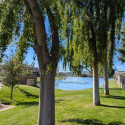
More like Shaw Butte Recreation Area
Recommended Reviews - Shaw Butte Recreation Area
Start your review...

Reviews With Photos - Shaw Butte Recreation Area

My entire life I've looked at this mountain. This mountain has stood over my childhood memories. Its there, still, in my family photos. Its shadow constantly there. Oddly enough, not once did my family ever venture onto the mountain to explore. Its right there and we never took a walk or ventured over, ever. I was raised by fat alcoholics so that could be the issue. Or maybe they thought hiking was for hippies. Could be both. I brought my man to Phoenix to see the glory that I was raised in. Our first morning there we got up before the rain and headed over to the visitor center to start our hike. We were told there were petroglyphs on the mountain so my goal was to find those. The map was confusing and I had to use our AllTrails app to get better accuracy. We never found the petroglyphs. We did almost go to the peak with the TV towers but I said screw it. I want petroglyphs and the views from almost the top are fine. I loved the quartz stone everywhere. You can see where the veins of the quartz goes through the hills. The colors are gorgeous. The views are gorgeous as well. Definitely study the map before you come and plan accordingly.


This is a 5 mile roundtrip which crosses some desert, and then up a road to some antennas and satellite dishes. It's a pretty easy hike, just annoyingly uphill for what seems to be a long ass time. Took a couple of wrong turns on the way back. Try to remember where you came from. Total time up and back was 01:31:11. This was my second of four mountains, one Saturday in April.

Well, here's the thing: this is still my favorite place to hike in all of Phoenix. I wake up thinking about it sometimes, like a lover calling me back! (too much?) But I do. And I go. I used to live nearby and I would walk the whole stretch of desert (trail 100) along Thunderbird, take the underground passage and walk more desert just to access the trailhead here. When parking: I've done the lot off 7th Street, where the "North Mountain Visitor Center" is or the smaller lot just off Tbird at Aster/Central. I MUCH prefer parking at the Visitor Center lot since it gives you a nice stretch of desert to walk (warm-up) prior to gaining elevation. My preferred route is to head northwest from that parking lot along trail 100 (orange on the photo), then you pick up that unmarked line continuing northwest (on map shown) until you connect to the yellow Shaw Butte trailhead. It's up and up from there. It winds a little. A little steep but then levels out pretty nicely while still gaining elevation. This is a considerably easier hike and generally much less crowded than either Squaw Peak or Camelback but of course, keep that adequate hydration and nutrition handy. Very few shady spots on this one. At the top, there's a mess of antennas and such but I'll never forget on one of my first hikes here, a man launching a hang-glider off the back side (up by antennas and pointed out toward White Tanks.) I believe they still do these launches, but much less common than in the past. It was a cool site to see. Speaking of launches...flew over my mountain bike handlebars! Stupid! Not on the trail, but back at the parking lot - new placement of one of those concrete parking stops - took me down. We laughed. Thankfully! We used to also do a terrific calf work-out on the back stretch of road up near the top (paved and steep!) And this, sad but true..haven't seen "the lone burro" in a very long time. I did say "hello and adios" to him last time - some ten years back. I had a feeling. I would love to see a burro again around here, but those days may be gone. I've only done the full loop a couple times, I found it somewhat slow "around the back" so I always just descend by retracing my steps. As always, free access, free parking! Thanks, Phoenix!

Our hike up to the towers began at the trail just south of the visitor center. This portion of the trail, about a mile or so, was mostly flat through the desert and allowed us to get in a great jog before reaching the base. Trail markers are not clear and there are a few options up to the towers, some easy and some difficult. We had to ask a few hikers along the way if we were on the right path heading in the right direction. We were pointed in the direction of the difficult hike which of course we took. So up we went steady, resting and short bursting all the way up to the towers. We reached the towers, rested for a bit, took in the view and began our descent on the opposite side of the mountain. The north potion of the slope led us back to the flat-lands and yet another sprint/jog to the visitor center were we came upon a group people in a T'ai Chi session. That was nice. Tip: This is a great hike if you want to include some sprint/jog activity. Hike Length: 5 miles round trip Difficulty: Moderately strenuous Facilities: Water, restrooms and a very nice visitor center with staff.

Just finished a long hike. Felt pretty good. Today instead of hiking up the butte I took trails that travel west and circle around. The Sonoran Desert fauna today was a little scarce but I did hear an owl, saw a coyote, a rabbit and a variety of small birds. The flora was exceptionally green especially with the grasses up, which actually look like winter rye from peoples yards. One qt of water was more than good. The air temp was a little chilly but I really enjoy days like today.

I had planned on doing a lot of relaxation this weekend, but wouldn't you know, the weather had something else in store, and I couldn't just hole up and avoid the outdoors. Yesterday I wanted a relaxing stroll, but was sick of the city, so I drove on up to Shaw Butte to do a relaxing loop. Parking in this location is limited, and a little awkward (almost slashed my tires through the do not enter section) but it doesn't seem to get as crowded and should suffice. The entrance has a map of the area and trails you can take. The path was fairly easy to follow and I did manage to stay on a path (tho not always the one I was supposed to be on) at all times. I also managed to get myself back to my car, so that's always a bonus. There were a few others there that had managed to get themselves lost due to unclear path marking, but one look at a map and it's easy to get your bearings straight again. The path was beautiful. Not completely scenic, as parts still have the road visible, but it was quiet and peaceful and the sky was gorgeous that day. I pretty much had the trail to myself most of the time with everyone pretty evenly spaced out and ended up doing some dance hiking to my iPod without injuring myself on the trail, which speaks to the ease of the hike. Not really any steep parts or loose rock on the loop trail. Perfect for low maintenance hiking days. It was my first trip, but I don't see it being my last. Seems like there are plenty of trails that start there that would be fun to venture on.

I love this trail, it's especially good for early morning hikes with my dogs. It's not too steep and doesn't require an immense amount of rock climbing at any point... So my little chihuahua and dachshund are able to do it without any problems. My favorite part about this hike, is going off trail, you get great views of the entire phoenix area and you can do some serious rock climbing if you want. Like everyone else has said, keep an eye on which way you came from.....you can get lost and it's a pain in the butt trying to find your way back. I like this trail cause I rarely see it getting very busy (unlike camelback) and it seems like a peaceful/mild hike. Definitely one I'll be coming back to.

Something has to be said about the little guys of Phoenix's hiking universe. In a land where people switch from hiking Camelback to Piestewa Peak and then back to Camelback, the big cluster of trails that sprawl over north Phoenix can easily be overlooked. But I think it's great to take a break from the norm and explore new places once in a while - and also to step back and hike for hiking's sake and not think about "this climb is going to burn x calories at y heart rate in order to leave me with -z% body fat." A bunch of these said trails in north Phoenix fall within the Shaw Butte Recreation Area, which I initially hiked back in spring and have been returning to since then, and I will say that I completely underestimated the experience because let's face it, Shaw Butte is ugly. At least from afar. If you're driving north on I-17 and look to the east, you'll see this nondescript brown hill topped with an antenna farm paired with it's just as ugly sister, North Mountain. Doesn't really attract you, does it. But it's a great hike nevertheless. You park at a small lot in a residential neighborhood on Central Ave just south of Thunderbird and head into the Shaw Butte area. From here, you have two options - you can head up counterclockwise to the summit by taking the service road (which 99% of the people do - including families with kids, older folks taking leisurely walks, avid joggers, etc.) or, if you're like me, by following Trail 306/100 clockwise along the floor for about 1.5 miles until you start ascending Shaw Butte from the south side. I actually enjoyed walking on a flat surface for such a distance - I really appreciated the desert landscape a lot more as well as the view of the downtown skyline as the trail made its curve. The ascent itself has some parts which are reminiscent of Piestewa's stairmasterism, but they don't go on for nearly as long and level off time and time again for you to enjoy the views. As you're getting closer to the summit, you'll come across the foundations of Cloud 9, a fine dining restaurant with a sweeping view of the Valley which was only accessible by a 4x4 on the aforementioned service road. It burned down in the 60's and was never rebuilt. Now a graffiti-ridden ghost, it's cool to stand here and imagine what a restaurant here would have been like, especially back in the early 60's when Phoenix was a fraction of its current size. Then you can continue back onto Trail 306 and head up to the summit, where you're in antennae city. Oddly enough, most people who take the service road up from the north side don't walk around and hang out here. I'm usually just hanging out here by myself. Actually, let me correct that. I'm usually just hanging out here with a couple of iguanas who're sunning themselves on the rocks adjacent to the one I'm sitting on. I sit here for about 10 minutes, taking in the view looking south (usually), eating a snack, chilling with the iguanas, and then continuing in my clockwise direction by heading down the service road and back to my car. For me, this loop is usually a 2 hour excursion. As I said, most people usually just stick to the service road to go up and down, so you have a good chance of having the whole trail on the south side of Shaw Butte all to yourself. No jostling with other people. No stepping to the side to let someone who's doing their third consecutive ascent whiz right past you. Just you. At whichever pace you want to go. This is by no means minimizing Camelback or Piestewa Peak, because they're awesome hikes in their own right, but Shaw Butte and other north Phoenix trails bring me back to appreciating hiking and exploring again. At least in the city. Sure, they're nowhere near as tall, intense, eyecatching or crowded as the big guys, but they're still sitting there as part of the Phoenix Mountain Reserve, so why not hit 'em once in a while? It pays to mix it up now and then. 4 stars.


This is becoming one of my favorite trails. I start at the N. Mtn visitors center and take the long, rocky, but definitely worth it trail up to the towers. I have been trying to run most of it but I always get winded once I get to the base of the incline. Be careful as it is pretty rocky and your trip down can be dangerous if you are not careful. Especially if you tend to run down like I try to do. I am happy to say I am not as winded as I use to be when I first started visiting this trail. One of these days I will run from top to bottom.

4 months ago
If the parking lot is crowded just drive over to N 8th Ave and park outside of Shadow Rock United Church of Christ where there is plenty of free parking. It's a pretty easy two mile hike up to the top where the cell towers are located and you can take in the views. This is a popular hiking location so you won't be alone. read more


1 year ago
A wonderful morning hike spot with gorgeous views of the valley. Shaw Butte is a 4.0 mile loop with 654 feet elevation change. My favorite way to start a day is with a sunrise hike here. Other hikers are typically very friendly. Tips: - check online for trail hours. The parking lot at the trailhead is only open during these times. - dogs are allowed if leashed - visit around Christmas time too catch a little decorated tree on the trail! Such a charming tradition read more


Wanted to get out with the family to soak in Gods beauty, count our blessings and share what we're thankful for this past year. So what better way than to go for a sunset hike to the top of Shaw Butte Trailhead. 2.8 miles out/back Elevation gain 764 90% of trail is climbing reward is spectacular views of the city. read more
My entire life I've looked at this mountain. This mountain has stood over my childhood memories. Its there, still, in my family photos. Its shadow constantly there. Oddly enough, not once did my family ever venture onto the mountain to explore. Its right there and we never took a walk or ventured over, ever. I was raised by fat alcoholics so that could be the issue. Or maybe they thought hiking was for hippies. Could be both. I brought my man to Phoenix to see the glory that I was raised in. Our first morning there we got up before the rain and headed over to the visitor center to start our hike. We were told there were petroglyphs on the mountain so my goal was to find those. The map was confusing and I had to use our AllTrails app to get better accuracy. We never found the petroglyphs. We did almost go to the peak with the TV towers but I said screw it. I want petroglyphs and the views from almost the top are fine. I loved the quartz stone everywhere. You can see where the veins of the quartz goes through the hills. The colors are gorgeous. The views are gorgeous as well. Definitely study the map before you come and plan accordingly. read more


As all of our great trails in the valley Shaw Butte is great nice four mile hike to the top of the towers great view of the valley and if you go inside the visitor center cold water and clean bathrooms my favorite spot or I ride my bike from read more

This is a 5 mile roundtrip which crosses some desert, and then up a road to some antennas and satellite dishes. It's a pretty easy hike, just annoyingly uphill for what seems to be a long ass time. Took a couple of wrong turns on the way back. Try to remember where you came from. Total time up and back was 01:31:11. This was my second of four mountains, one Saturday in April. read more


Well, here's the thing: this is still my favorite place to hike in all of Phoenix. I wake up thinking about it sometimes, like a lover calling me back! (too much?) But I do. And I go. I used to live nearby and I would walk the whole stretch of desert (trail 100) along Thunderbird, take the underground passage and walk more desert just to access the trailhead here. When parking: I've done the lot off 7th Street, where the "North Mountain Visitor Center" is or the smaller lot just off Tbird at Aster/Central. I MUCH prefer parking at the Visitor Center lot since it gives you a nice stretch of desert to walk (warm-up) prior to gaining elevation. My preferred route is to head northwest from that parking lot along trail 100 (orange on the photo), then you pick up that unmarked line continuing northwest (on map shown) until you connect to the yellow Shaw Butte trailhead. It's up and up from there. It winds a little. A little steep but then levels out pretty nicely while still gaining elevation. This is a considerably easier hike and generally much less crowded than either Squaw Peak or Camelback but of course, keep that adequate hydration and nutrition handy. Very few shady spots on this one. At the top, there's a mess of antennas and such but I'll never forget on one of my first hikes here, a man launching a hang-glider off the back side (up by antennas and pointed out toward White Tanks.) I believe they still do these launches, but much less common than in the past. It was a cool site to see. Speaking of launches...flew over my mountain bike handlebars! Stupid! Not on the trail, but back at the parking lot - new placement of one of those concrete parking stops - took me down. We laughed. Thankfully! We used to also do a terrific calf work-out on the back stretch of road up near the top (paved and steep!) And this, sad but true..haven't seen "the lone burro" in a very long time. I did say "hello and adios" to him last time - some ten years back. I had a feeling. I would love to see a burro again around here, but those days may be gone. I've only done the full loop a couple times, I found it somewhat slow "around the back" so I always just descend by retracing my steps. As always, free access, free parking! Thanks, Phoenix! read more

Our hike up to the towers began at the trail just south of the visitor center. This portion of the trail, about a mile or so, was mostly flat through the desert and allowed us to get in a great jog before reaching the base. Trail markers are not clear and there are a few options up to the towers, some easy and some difficult. We had to ask a few hikers along the way if we were on the right path heading in the right direction. We were pointed in the direction of the difficult hike which of course we took. So up we went steady, resting and short bursting all the way up to the towers. We reached the towers, rested for a bit, took in the view and began our descent on the opposite side of the mountain. The north potion of the slope led us back to the flat-lands and yet another sprint/jog to the visitor center were we came upon a group people in a T'ai Chi session. That was nice. Tip: This is a great hike if you want to include some sprint/jog activity. Hike Length: 5 miles round trip Difficulty: Moderately strenuous Facilities: Water, restrooms and a very nice visitor center with staff. read more


15 years ago
Just finished a long hike. Felt pretty good. Today instead of hiking up the butte I took trails that travel west and circle around. The Sonoran Desert fauna today was a little scarce but I did hear an owl, saw a coyote, a rabbit and a variety of small birds. The flora was exceptionally green especially with the grasses up, which actually look like winter rye from peoples yards. One qt of water was more than good. The air temp was a little chilly but I really enjoy days like today. read more


I had planned on doing a lot of relaxation this weekend, but wouldn't you know, the weather had something else in store, and I couldn't just hole up and avoid the outdoors. Yesterday I wanted a relaxing stroll, but was sick of the city, so I drove on up to Shaw Butte to do a relaxing loop. Parking in this location is limited, and a little awkward (almost slashed my tires through the do not enter section) but it doesn't seem to get as crowded and should suffice. The entrance has a map of the area and trails you can take. The path was fairly easy to follow and I did manage to stay on a path (tho not always the one I was supposed to be on) at all times. I also managed to get myself back to my car, so that's always a bonus. There were a few others there that had managed to get themselves lost due to unclear path marking, but one look at a map and it's easy to get your bearings straight again. The path was beautiful. Not completely scenic, as parts still have the road visible, but it was quiet and peaceful and the sky was gorgeous that day. I pretty much had the trail to myself most of the time with everyone pretty evenly spaced out and ended up doing some dance hiking to my iPod without injuring myself on the trail, which speaks to the ease of the hike. Not really any steep parts or loose rock on the loop trail. Perfect for low maintenance hiking days. It was my first trip, but I don't see it being my last. Seems like there are plenty of trails that start there that would be fun to venture on. read more

12 years ago
I love this trail, it's especially good for early morning hikes with my dogs. It's not too steep and doesn't require an immense amount of rock climbing at any point... So my little chihuahua and dachshund are able to do it without any problems. My favorite part about this hike, is going off trail, you get great views of the entire phoenix area and you can do some serious rock climbing if you want. Like everyone else has said, keep an eye on which way you came from.....you can get lost and it's a pain in the butt trying to find your way back. I like this trail cause I rarely see it getting very busy (unlike camelback) and it seems like a peaceful/mild hike. Definitely one I'll be coming back to. read more


6 years ago
Something has to be said about the little guys of Phoenix's hiking universe. In a land where people switch from hiking Camelback to Piestewa Peak and then back to Camelback, the big cluster of trails that sprawl over north Phoenix can easily be overlooked. But I think it's great to take a break from the norm and explore new places once in a while - and also to step back and hike for hiking's sake and not think about "this climb is going to burn x calories at y heart rate in order to leave me with -z% body fat." A bunch of these said trails in north Phoenix fall within the Shaw Butte Recreation Area, which I initially hiked back in spring and have been returning to since then, and I will say that I completely underestimated the experience because let's face it, Shaw Butte is ugly. At least from afar. If you're driving north on I-17 and look to the east, you'll see this nondescript brown hill topped with an antenna farm paired with it's just as ugly sister, North Mountain. Doesn't really attract you, does it. But it's a great hike nevertheless. You park at a small lot in a residential neighborhood on Central Ave just south of Thunderbird and head into the Shaw Butte area. From here, you have two options - you can head up counterclockwise to the summit by taking the service road (which 99% of the people do - including families with kids, older folks taking leisurely walks, avid joggers, etc.) or, if you're like me, by following Trail 306/100 clockwise along the floor for about 1.5 miles until you start ascending Shaw Butte from the south side. I actually enjoyed walking on a flat surface for such a distance - I really appreciated the desert landscape a lot more as well as the view of the downtown skyline as the trail made its curve. The ascent itself has some parts which are reminiscent of Piestewa's stairmasterism, but they don't go on for nearly as long and level off time and time again for you to enjoy the views. As you're getting closer to the summit, you'll come across the foundations of Cloud 9, a fine dining restaurant with a sweeping view of the Valley which was only accessible by a 4x4 on the aforementioned service road. It burned down in the 60's and was never rebuilt. Now a graffiti-ridden ghost, it's cool to stand here and imagine what a restaurant here would have been like, especially back in the early 60's when Phoenix was a fraction of its current size. Then you can continue back onto Trail 306 and head up to the summit, where you're in antennae city. Oddly enough, most people who take the service road up from the north side don't walk around and hang out here. I'm usually just hanging out here by myself. Actually, let me correct that. I'm usually just hanging out here with a couple of iguanas who're sunning themselves on the rocks adjacent to the one I'm sitting on. I sit here for about 10 minutes, taking in the view looking south (usually), eating a snack, chilling with the iguanas, and then continuing in my clockwise direction by heading down the service road and back to my car. For me, this loop is usually a 2 hour excursion. As I said, most people usually just stick to the service road to go up and down, so you have a good chance of having the whole trail on the south side of Shaw Butte all to yourself. No jostling with other people. No stepping to the side to let someone who's doing their third consecutive ascent whiz right past you. Just you. At whichever pace you want to go. This is by no means minimizing Camelback or Piestewa Peak, because they're awesome hikes in their own right, but Shaw Butte and other north Phoenix trails bring me back to appreciating hiking and exploring again. At least in the city. Sure, they're nowhere near as tall, intense, eyecatching or crowded as the big guys, but they're still sitting there as part of the Phoenix Mountain Reserve, so why not hit 'em once in a while? It pays to mix it up now and then. 4 stars. read more


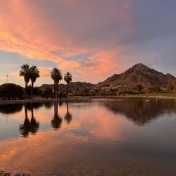
 Papago Park as seen from Cloud 9 - Parks Near Me - Phoenix, Arizona")
18 years ago
16 years ago
9 years ago
10 years ago
14 years ago
This is a quick trail that will get your heart pumping. No services so take enough water but great view from atop Shaw Butte! If you are lucky, you'll get to see parasailors hovering above you. read more


8 years ago
This is becoming one of my favorite trails. I start at the N. Mtn visitors center and take the long, rocky, but definitely worth it trail up to the towers. I have been trying to run most of it but I always get winded once I get to the base of the incline. Be careful as it is pretty rocky and your trip down can be dangerous if you are not careful. Especially if you tend to run down like I try to do. I am happy to say I am not as winded as I use to be when I first started visiting this trail. One of these days I will run from top to bottom. read more


16 years ago
13 years ago
10 years ago
14 years ago
12 years ago
More info about Shaw Butte Recreation Area
N Central Ave & E Aster Dr
Phoenix, AZ 85073
Directions
Hours
Outdoor Amenities
Ask the Community - Shaw Butte Recreation Area
Review Highlights - Shaw Butte Recreation Area
You might also consider


Shaw Butte Recreation Area - parks - Updated July 2026
Best of Phoenix
People found Shaw Butte Recreation Area by searching for…
Scenic Night View in Phoenix, Arizona
Scenic Drive in Phoenix, Arizona
Sunset View in Phoenix, Arizona
Scenic Overlook in Phoenix, Arizona
Parks for Kids in Phoenix, Arizona
Sunrise View in Phoenix, Arizona
Places to Walk at Night in Phoenix, Arizona
Paved Walking Trails in Phoenix, Arizona
Sunrise Hike in Phoenix, Arizona
Attractions in Phoenix, Arizona
Watch Sunset in Phoenix, Arizona
Hiking Trails in Phoenix, Arizona
Running Trails in Phoenix, Arizona
Free Parking in Phoenix, Arizona
Night Hike in Phoenix, Arizona
Easy Hikes in Phoenix, Arizona
Dog Swimming in Phoenix, Arizona
Off Road Trails in Phoenix, Arizona
Picnic Spots in Phoenix, Arizona
Free Things to Do With Kids in Phoenix, Arizona
Trending Searches in Phoenix, AZ
4th Of July Fireworks in Phoenix, AZ
Baseball Fields in Phoenix, AZ
Black Owned Nail Salons in Phoenix, AZ
Dog Friendly Beaches in Phoenix, AZ
Kids Activities Outdoor in Phoenix, AZ
Outdoor Basketball Courts in Phoenix, AZ
Places To Walk Around in Phoenix, AZ
Strawberry Picking in Phoenix, AZ
Browse Articles
Browse Nearby
BEST of Phoenix, Arizona Coffee near Shaw Butte Recreation Area
BEST of Phoenix, Arizona Things to Do near Shaw Butte Recreation Area
BEST of Phoenix, Arizona Restaurants near Shaw Butte Recreation Area
BEST of Phoenix, Arizona Breakfast near Shaw Butte Recreation Area
BEST of Phoenix, Arizona Playgrounds near Shaw Butte Recreation Area
BEST of Phoenix, Arizona Picnic Areas near Shaw Butte Recreation Area
BEST of Phoenix, Arizona Star Gazing near Shaw Butte Recreation Area
BEST of Phoenix, Arizona Campgrounds near Shaw Butte Recreation Area
BEST of Phoenix, Arizona Sightseeing near Shaw Butte Recreation Area
Browse Brands
Related Searches in Phoenix, AZ
Best Off Leash Dog Parks in Phoenix, Arizona
Best Parks for Parties and Events in Phoenix, Arizona
Best Water Parks for Kids in Phoenix, Arizona
Check Out Great Playgrounds in Phoenix, Arizona
Discover Baseball Fields Around Phoenix, Arizona
Discover Beautiful Garden Spots in Phoenix, Arizona
Discover Fun Toddler Parks in Phoenix, Arizona for Your Little One
Discover Lakes & Ponds to Explore in Phoenix, Arizona
Discover Popular Photo Spots in Phoenix, Arizona
Discover Soccer Fields in Phoenix, Arizona Near You
Discover Top Nature Parks to Visit in Phoenix, Arizona
Discover Top Scenic Spots to Visit in Phoenix, Arizona
Discover Top State Parks to Visit in Phoenix, Arizona
Discover Walking Parks in Phoenix, Arizona Near You
Discover the Best Beaches in Phoenix, Arizona
Discover the Best Kids Park Spots in Phoenix, Arizona
Enjoy the Best Picnic Spots and Ideas in Phoenix, Arizona
Enjoy the Best Walking Trails in Phoenix, Arizona
Explore Beautiful Botanical Gardens in Phoenix, Arizona
Explore Family-Friendly Zoos and Wildlife in Phoenix, Arizona
Explore Free Picnic Areas Around Phoenix, Arizona
Explore Fun Activities to Do in Phoenix, Arizona
Explore Parks With Pull Up Bars in Phoenix, Arizona
Explore Popular Campgrounds Near Phoenix, Arizona
Explore Popular Picnic Areas Around Phoenix, Arizona
Explore Popular RV Parks Around Phoenix, Arizona
Explore Popular Recreation Centers Around Phoenix, Arizona
Explore Scenic Lakes to Visit in Phoenix, Arizona
Explore Top Dog Parks in Phoenix, Arizona Near You
Explore Top Water Parks in Phoenix, Arizona Today
Explore the Best Trail Options in Phoenix, Arizona
Find Parks and Recreation Activities in Phoenix, Arizona
Find Top Dog Friendly Parks to Visit in Phoenix, Arizona
Find Top Skate Parks in Phoenix, Arizona for All Skill Levels
Find a Park With BBQ Pits in Phoenix, Arizona
Find the Best Parks BBQ Grills in Phoenix, Arizona
Find the Best Parks for Picnics in Phoenix, Arizona
Have Fun at a Splash Pad in Phoenix, Arizona
Locate Tennis Courts Around Phoenix, Arizona
Parks With Basketball Courts for Games in Phoenix, Arizona
Picnic Areas With BBQ Pits Available in Phoenix, Arizona
Play at a Splash Pad Park in Phoenix, Arizona
Popular Fishing Spots to Explore in Phoenix, Arizona
Popular Outdoor Activities to Try in Phoenix, Arizona
Popular Places to Take Pictures in Phoenix, Arizona
Top Hiking Trails to Explore in Phoenix, Arizona
Top Running Trails to Explore in Phoenix, Arizona
Top Swimming Lakes to Enjoy in Phoenix, Arizona