Bartlett Lake Photos


You might also consider
More like Bartlett Lake
Recommended Reviews - Bartlett Lake
Start your review...

Reviews With Photos


Nice lake with good, long, wide boatramp. They also have a picnic area and camping area. Despite being relatively close to Phoenix/Easy Valley area, this lake isn't nearly as busy as other lakes close by. Went a couple times in early April and bass fishing was good - not huge, but consistent bite.

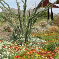
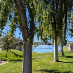
It's a great place for a picnic, especially Rattlesnake Cove. Plenty of ramadas and toilets. And when you go in mid-March, there are usually lots of Mexican poppies and lupine blossoming closer to the lake. Also, in summer, it's swimmable so it's a good place to cool off. But it does get real busy on weekends.

Such an amazing spot! My friend took me hear after hearing that I needed a little day get away from all the hustle and bustle of normal day life. We drove around the lake, getting out and walking around and just enjoying nature around us. Very clean, pretty easy to get here. I can't wait to come back on a boat next time to enjoy the lake itself!

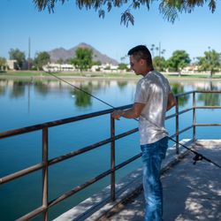
Loved the hike! Started at Rattlesnake Cove and went out 1 mile, then came back 1 mild. You can park in the "day camp" area where there are bathrooms and a lot of picnic tables set up. Many people were spending the day there, eating, playing in the water, and fishing off the pier/dock. The online negative is that there was A LOT of trash, people just need to pick up after themselves to keep the place pretty and usable for all.


What a diamond in the rough..... Literally it's in the back of my yard. Since living on stage pass coach the mountains are my friends but I did the water... To my surprise my husband and I kept hearing about a like that was 15 mins from us. So we decided to take a little trip... WOW!!!!! Gorgeously beautiful.... The water is so blue and the scenic view.... Make sure you take sunscreen and wear loose clothing or very little clothing depending on the weather!!! Don't forget the wine!!!

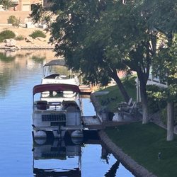
A beautiful area and lake that have many activities to offer! We went for a Sunday drive that ended up at Bartlett Lake! We weren't very well prepared- it has a small store and restaurant with some offerings. It would be fun to pack a picnic and come back and rent a pontoon boat for cruising!

I grew up a mile away from the beach and I've only been in AZ for about 2 years with maybe 10 lake trips under my belt (mainly to Lake Las Vegas and Havasu during my college years with a couple Big Bear Lake trips for church camp in high school) so I am still getting used to not hoping on my bike to go body surfing whenever I get bored, but this place exceeded my expectations without a doubt. My friend just fixed up her jet skis and invited me to join her for a lake day. I was a bit confused at first because I had always rented a boat when going to the lake in the past and was wondering what you could possibly do on separate water vehicles. After all the lake is meant for finding someone who is naïve enough to be tricked into thinking that being a boat captain is the best opportunity ever so that rest of us can drink while we blast Lonely Island's I'm On A Boat. Am I right? We got on the skis from the docking point and found a nice area at Bartlett Flatts to get set up. We played some music, had lunch, enjoyed the sun, and went out for a couple ski rides. Her parents joined us later with their boat, but it wasn't a necessity to enjoy a day at the lake. Bartlett lake reminds me a lot of Strands Beach in Dana Point and I fell like you could even enjoy going without a watercraft by finding a nice place to park your car and setting up some chairs and a sun shade. It is a truly versatile area that I look forward to enjoying frequently. I'm right off where the 51 and 101 meet and it is about 45 minutes away from there so the drive isn't bad either.
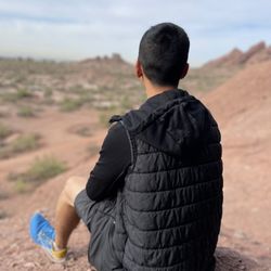
Pros: Bartlett lake trail is incredibly scenic with many spectacular views. (It took about 4 hours to hike the whole thing and I would say is moderately challenging.) Cons: Trail is not always clearly marked and there are many fallen cacti in the path, making for a treacherous journey. In the future, if I were to come back I would only do half of the trail. Make sure to bring lots of water!

5 months ago
We decided to drive over to check out the nearby Horseshoe Dam in hopes to catch the spillway release and the waterfall it creates into the Verde River and then head over to Bartlett Lake to see the start of the wildflower blooms. Totally worth seeing both when in the area. The drive was beautiful. Water levels are a bit low, but still amazing. The flowers are already in bloom, but will be even better by end of February into March if you'd love to see them. I love poppies but there are so many more flowers also in bloom, to see the best area I'd recommend the area just before Rattlesnake Cove . There is a small trail with roadside parking if lucky. Or can park in the cove parking and small hike back up to area. You do need to pay for a rec pass if parking and spending the day. You can purchase at stores nearby or roadside spots you'll see along the way. Traffic wasn't too bad today but as it warms up and flowers more in bloom be prepared. There is also a restaurant near the boat dock as well. read more


1 year ago
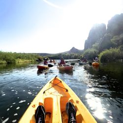
Beautiful lake! Not too crowded, other than holiday's. Great for paddling, kayaking etc. bring water shoes to be comfy as it is rocky! read more


Nice lake with good, long, wide boatramp. They also have a picnic area and camping area. Despite being relatively close to Phoenix/Easy Valley area, this lake isn't nearly as busy as other lakes close by. Went a couple times in early April and bass fishing was good - not huge, but consistent bite. read more


It's a great place for a picnic, especially Rattlesnake Cove. Plenty of ramadas and toilets. And when you go in mid-March, there are usually lots of Mexican poppies and lupine blossoming closer to the lake. Also, in summer, it's swimmable so it's a good place to cool off. But it does get real busy on weekends. read more

3 years ago
Such an amazing spot! My friend took me hear after hearing that I needed a little day get away from all the hustle and bustle of normal day life. We drove around the lake, getting out and walking around and just enjoying nature around us. Very clean, pretty easy to get here. I can't wait to come back on a boat next time to enjoy the lake itself! read more


6 years ago
Loved the hike! Started at Rattlesnake Cove and went out 1 mile, then came back 1 mild. You can park in the "day camp" area where there are bathrooms and a lot of picnic tables set up. Many people were spending the day there, eating, playing in the water, and fishing off the pier/dock. The online negative is that there was A LOT of trash, people just need to pick up after themselves to keep the place pretty and usable for all. read more


3 years ago
Great Lake with many amenities! We would highly recommend to anyone! We really enjoyed exploring the different read more


What a diamond in the rough..... Literally it's in the back of my yard. Since living on stage pass coach the mountains are my friends but I did the water... To my surprise my husband and I kept hearing about a like that was 15 mins from us. So we decided to take a little trip... WOW!!!!! Gorgeously beautiful.... The water is so blue and the scenic view.... Make sure you take sunscreen and wear loose clothing or very little clothing depending on the weather!!! Don't forget the wine!!! read more

A beautiful area and lake that have many activities to offer! We went for a Sunday drive that ended up at Bartlett Lake! We weren't very well prepared- it has a small store and restaurant with some offerings. It would be fun to pack a picnic and come back and rent a pontoon boat for cruising! read more


Business owner information
Laurie C.
Jacque, thanks for the review. The drive out to the lake is…
8 years ago
4 years ago
I grew up a mile away from the beach and I've only been in AZ for about 2 years with maybe 10 lake trips under my belt (mainly to Lake Las Vegas and Havasu during my college years with a couple Big Bear Lake trips for church camp in high school) so I am still getting used to not hoping on my bike to go body surfing whenever I get bored, but this place exceeded my expectations without a doubt. My friend just fixed up her jet skis and invited me to join her for a lake day. I was a bit confused at first because I had always rented a boat when going to the lake in the past and was wondering what you could possibly do on separate water vehicles. After all the lake is meant for finding someone who is naïve enough to be tricked into thinking that being a boat captain is the best opportunity ever so that rest of us can drink while we blast Lonely Island's I'm On A Boat. Am I right? We got on the skis from the docking point and found a nice area at Bartlett Flatts to get set up. We played some music, had lunch, enjoyed the sun, and went out for a couple ski rides. Her parents joined us later with their boat, but it wasn't a necessity to enjoy a day at the lake. Bartlett lake reminds me a lot of Strands Beach in Dana Point and I fell like you could even enjoy going without a watercraft by finding a nice place to park your car and setting up some chairs and a sun shade. It is a truly versatile area that I look forward to enjoying frequently. I'm right off where the 51 and 101 meet and it is about 45 minutes away from there so the drive isn't bad either. read more


11 years ago
Pros: Bartlett lake trail is incredibly scenic with many spectacular views. (It took about 4 hours to hike the whole thing and I would say is moderately challenging.) Cons: Trail is not always clearly marked and there are many fallen cacti in the path, making for a treacherous journey. In the future, if I were to come back I would only do half of the trail. Make sure to bring lots of water! read more


5 years ago
6 years ago
7 years ago
13 years ago
Been here a bazillion times over the last 35+ years. Winter fishing is always a crap shoot (super slow), but is always fun. Later spring/early summer is much better for fishing, but you really have to suck it up dealing with a lot of, well, you know, messed-up partier's (I'm being nice). There are several boat ramps, a marina, and party ramadas at various places. Can be an extreme mad house in summer! read more

13 years ago
13 years ago
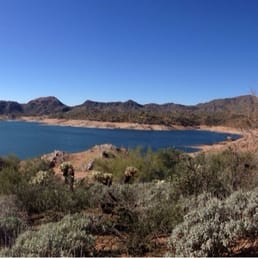
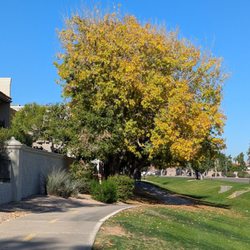
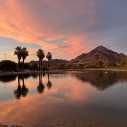
Bartlett Lake is a wonderful escape to a large (for Arizona) body of water with semi-sandy beaches that lets you feel like you're practically at the beach. Boats going by cause small ripples that make a lovely wave-like sound. The area is very pretty. The downside is that it takes forever to get there (I live in Cave Creek and it was a good 40 minutes). The drive in is gorgeous, but time consuming. My husband & I came to check it out on a Saturday, with the intention of doing a hike around the lake. The ranger station was closed and the store where you purchase the $6 required parking pass did not have any trail maps. We started the Palo Verde trail (#512) which after a few minutes, mysteriously disappears. Just vanishes. We trekked around for a while trying to pick it back up, which was fun, but ended up having to return because there was so much cacti everywhere. The 5 minutes of the trail was very pretty, but I'd recommend getting to talk to a ranger/getting a map before going on it. Since the lake is very pretty, we just sat on the beach and read for a few hours. No real complaints, but it would have been nice to have been able to do the hike. read more


11 years ago
My husband and I have been going to this lake to jetski for 20 years. It is beautiful, clean and not congested. We now go on Mondays and share the lake with about 10 people. I feel so safe out there with my kids. Last week my son and his girlfriend broke down and a fellow boater towed them in. I have been to other lakes in AZ but the feel is just different. I would recommend this lake to anyone. Its a wonderful experience every time. read more


5 years ago
12 years ago
Beautiful area, lots of native vegetation. We could not find the "trails" but enjoyed the drive through the park and the beach. Probably super crowed in April/May...very quiet and enjoyable in February. read more


11 years ago
The address shown here on this page is obviously not Bartlett lake. In fact it's like 30 miles off. We drove to Bartlett Lake and just hiked around the water for a bit. Gorgeous views. We didn't know where to start our hiking (looking for a trail) so we asked the bait shop and they had no idea. Told us to go around to the back by camping area. No thanks- just stick by the water. read more

7 years ago
7 years ago
8 years ago
A nice hidden gem in Scottsdale. We were to supposed to hike but couldn't find the trail so we just decided to stay in the water. We had so much fun swimming. It was not too crowded on a Sunday mid morning. The water was cool enough to beat the 100 degree AZ temp. We had a great time and will definitely come back. read more

9 years ago
8 years ago
8 years ago
8 years ago
10 years ago
More info about Bartlett Lake
20808 E Bartlett Dam Rd
Scottsdale, AZ 85262
Directions
(602) 319-4151
Call Now
Visit Website
http://bartlettlake.com/
Hours
Outdoor Amenities
Other Amenities
Ask the Community - Bartlett Lake
Is there fishing from the shorelines?
Yes there is. Drive down North Lake Road and you will find the perfect spot.
Review Highlights - Bartlett Lake
You might also consider


Why does Yelp recommend reviews?
Bartlett Lake - hiking - Updated July 2026
Best of Scottsdale
People found Bartlett Lake by searching for…
Scenic Drive in Scottsdale, AZ
Fishing Spots in Scottsdale, AZ
Dog Swimming in Scottsdale, AZ
Swimming Holes in Scottsdale, AZ
Picnic Spots in Scottsdale, AZ
River Swimming in Scottsdale, AZ
Secluded Spots in Scottsdale, AZ
Public Running Track in Scottsdale, AZ
Hiking Trails With Waterfalls in Scottsdale, AZ
Things to Do in Scottsdale, AZ
Swimming Lakes in Scottsdale, AZ
Beach Camping in Scottsdale, AZ
Hidden Beach in Scottsdale, AZ
Lake Camping in Scottsdale, AZ
Trending Searches in Scottsdale, AZ
Beautiful Views in Scottsdale, AZ
Black Owned Nail Salons in Scottsdale, AZ
Cliff Jumping in Scottsdale, AZ
Dog Friendly Beaches in Scottsdale, AZ
Dog Friendly Trails in Scottsdale, AZ
Dog Swimming in Scottsdale, AZ
Fishing Pier in Scottsdale, AZ
Free Picnic Areas in Scottsdale, AZ
Jet Ski Rental in Scottsdale, AZ
Kayak Rental in Scottsdale, AZ
Kids Activities Outdoor in Scottsdale, AZ
Lakes & Ponds in Scottsdale, AZ
Lookout Points in Scottsdale, AZ
Off Road Trails in Scottsdale, AZ
Outdoor Activities in Scottsdale, AZ
Outdoor Basketball Courts in Scottsdale, AZ
Picnic Spots in Scottsdale, AZ
Places To Walk Around in Scottsdale, AZ
Public Beaches in Scottsdale, AZ
Public Pools in Scottsdale, AZ
Public Shower in Scottsdale, AZ
River Swimming in Scottsdale, AZ
River Tubing in Scottsdale, AZ
Running Trails in Scottsdale, AZ
Scenic Night View in Scottsdale, AZ
Scenic Overlook in Scottsdale, AZ
Scenic Restaurants in Scottsdale, AZ
Soccer Store in Scottsdale, AZ
Sunrise View in Scottsdale, AZ
Swimming Holes in Scottsdale, AZ
Swimming Lakes in Scottsdale, AZ
U Pick Farms in Scottsdale, AZ
Watch Sunset in Scottsdale, AZ
Browse Nearby
Browse Brands
Related Searches in Scottsdale, AZ
Affordable Kayak Rental Services in Scottsdale, Arizona
Best Fishing Locations and Guides in Scottsdale, Arizona
Best Nature Trails for Hiking in Scottsdale, Arizona
Best Off Leash Dog Parks in Scottsdale, Arizona
Best Parks for Parties and Events in Scottsdale, Arizona
Best Places for Horseback Riding in Scottsdale, Arizona
Best Water Parks for Kids in Scottsdale, Arizona
Best Waterfalls and Swimming Holes in Scottsdale, Arizona
Check Out Great Playgrounds in Scottsdale, Arizona
Check Out Off Road Trails in Scottsdale, Arizona
Discover Baseball Fields Around Scottsdale, Arizona
Discover Beautiful Garden Spots in Scottsdale, Arizona
Discover Dog Friendly Trails to Explore in Scottsdale, Arizona
Discover Fun Toddler Parks in Scottsdale, Arizona for Your Little One
Discover Lakes & Ponds to Explore in Scottsdale, Arizona
Discover Popular Photo Spots in Scottsdale, Arizona
Discover Scenic Mountain Bike Trails Near Scottsdale, Arizona
Discover Scenic Waterfall Spots in Scottsdale, Arizona
Discover Soccer Fields in Scottsdale, Arizona Near You
Discover Top Nature Parks to Visit in Scottsdale, Arizona
Discover Top Scenic Spots to Visit in Scottsdale, Arizona
Discover Top State Parks to Visit in Scottsdale, Arizona
Discover Walking Parks in Scottsdale, Arizona Near You
Discover the Best Beaches in Scottsdale, Arizona
Discover the Best Fishing Lake in Scottsdale, Arizona
Discover the Best Kids Park Spots in Scottsdale, Arizona
Discover the Best Night Hike Trails in Scottsdale, Arizona
Discover the Best Running Track in Scottsdale, Arizona
Enjoy Camping Adventures Around Scottsdale, Arizona
Enjoy Exciting Mountain Biking Adventures in Scottsdale, Arizona
Enjoy Kayaking Adventures in Scottsdale, Arizona
Enjoy River Tubing Adventures in Scottsdale, Arizona
Enjoy Tent Camping Spots Around Scottsdale, Arizona
Enjoy Water Activities and Fun in Scottsdale, Arizona
Enjoy a Beautiful Waterfall Hike in Scottsdale, Arizona
Enjoy the Best Picnic Spots and Ideas in Scottsdale, Arizona
Enjoy the Best Walking Path in Scottsdale, Arizona
Enjoy the Best Walking Trails in Scottsdale, Arizona
Exciting Cliff Jumping Spots in Scottsdale, Arizona
Experience Thrilling White Water Rafting in Scottsdale, Arizona
Explore Beautiful Botanical Gardens in Scottsdale, Arizona
Explore Beautiful Parks and Green Spaces in Scottsdale, Arizona
Explore Boat Rentals for Every Need in Scottsdale, Arizona
Explore Easy Hikes Perfect for All in Scottsdale, Arizona
Explore Family-Friendly Zoos and Wildlife in Scottsdale, Arizona
Explore Free Picnic Areas Around Scottsdale, Arizona
Explore Fun Activities to Do in Scottsdale, Arizona
Explore Parks With Lakes to Visit in Scottsdale, Arizona
Browse Articles
People who viewed Bartlett Lake also viewed
Blue Wash Trail
7 reviews
Butcher Jones
6 reviews
Spur Cross Ranch Conservation Area
51 reviews
Jewel Of The Creek
8 reviews
Roosevelt Lake Visitors Center
6 reviews
Needle Rock Rec Site
2 reviews
Bartlett Lake Marina
113 reviews
Reach 11 Recreation Area
19 reviews
Desert Hills Trailhead
4 reviews
Bartlett Lake
6 reviews