1. Cave Creek Trail

0

Cave Creek, AZ

Cancel

Open app

Search

Cave Creek Trail

5.0 (3 reviews)

Cave Creek Trail Photos

You might also consider

Recommended Reviews - Cave Creek Trail

Your trust is our priority, so businesses can't pay to alter or remove their reviews. Learn more about reviews.
Yelp app icon
Browse more easily on the app
Review Feed Illustration
Photo of Lisa C.
3
23
193

13 years ago

Helpful 3
Thanks 0
Love this 1
Oh no 1
Photo of Owen R.
598
3097
14115

10 years ago

Helpful 0
Thanks 0
Love this 1
Oh no 2

6 years ago

Helpful 0
Thanks 0
Love this 0
Oh no 0

Verify this business for free

People searched for Hiking 198 times last month within 15 miles of this business.

Verify this business

Cave Creek Regional Park - The view from Slate Trail

Cave Creek Regional Park

4.7(49 reviews)
11.6 mi

The park is well maintained and there is a good bit of parking near the trailheads. With the new…read moreyear, it is $10/car to enter or you can purchase an annual pass that covers all of the Maricopa County Parks (this is a great deal if you live here and enjoy getting outdoors). It has probably been ten years since I was last at this park -- mostly because I live on the opposite end of the Valley, but I still remember hiking the Go John Trail from twice that long ago. (Back then, we didn't have Internet-based recommendation systems or online trail guides, so we relied on books or the maps provided at the ranger stations.) That trail is no joke and the climb was a bit of a surprise as it has roughly 849 ft of elevation gain with some 10-15% grades over the course of nearly 6 miles. The elevation gain means some really nice desert views. I was here this time for a trail race, which is not run by the park, but we used the facilities and trails, which were well maintained and amazing to run on. I had a family of deer run across the trail about 100 yds in front of me on the home stretch of the race. I recommend all of the Maricopa County Parks and this one is no exception: each one has its own character and they're all worth visiting.
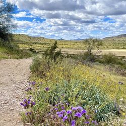
Slate Trail is a really enjoyable hike with classic Sonoran Desert scenery--towering saguaros,…read morerocky hillsides, and wide open views that make it feel peaceful without being remote. Parking was easy, and I appreciated the clean, convenient restrooms at the trailhead. That said, I do think the trail is slightly misrated. While it's listed as easy, the rocky footing and a few stretches with noticeable incline push it more into easy-moderate territory. It's absolutely doable, but hikers should be prepared for uneven terrain and some effort, especially if they're expecting a flat stroll. I brought my walking stick, and I'm glad I did. Overall, this is a beautiful, well-kept trail and a great way to experience Cave Creek Regional Park. With a more accurate difficulty rating, it would be a near-perfect hike.

Photos
Cave Creek Regional Park - Sunset

Sunset

Cave Creek Regional Park

See all

Black Mountain Summit Trail - First incline

Black Mountain Summit Trail

4.7(31 reviews)
7.1 mi

A great and cooler day for an exuberant hike up Black Mountain. The route is uphill and will get…read moreyour heart pumping within minutes. Wear appropriate shoes, take plenty of water, use sunscreen and use your shades or cap. This is not a beginner's walk. Smooth terrain initially and then it will become dirt and rocks. Watch your footing, stay on the trail and be alert. Rattlesnakes are still out so watch your step. Parking below.

How do you rate a hike like this?! 5 stars with alot of asterisks!…read more My fiancé is the experienced hiker. Lover of trail runs, marathons, and completing the types of challenging hikes they make documentaries about, this hike albeit steep was a breeze. He ran a few miles to the trailhead, hiked the mountain, then ran back to the hotel three times during our stay. I, on the other hand am not a fan of early mornings or strenuous hikes but I do love a good challenge. In lieu of beating my time up Toms Thumb, I tackled Black Mountain solo, and let me tell you, if my 4'11", geriatric knee having, asthmatic, former athlete self can complete this hike, you can too! Yes, it's pretty dang steep. I wish someone would have warned me that instead of riding switchbacks, you are climbing straight up, gaining elevation very quickly, but it does make for a fun change of pace. Personally, it took me an hour up, and an hour down (so two hours total), and my partner made it up in 30 minutes, and down in around the same (so an hour total). Here are a few tips no matter your skill level: *bring water, a snack or two, sunscreen, sunshades, and considering how steep this bad boy is, wear hiking shoes with good grips. I hiked in October 2024, so I'm not sure if you'd need to modify for other times of the year. *know that although there are a good amount of shops if you make it to the Spanish Village, there aren't a ton of walkable roads in the surrounding town of carefree. In fact, there are a few residents that live on this mountain, and may encounter cars on your way up to the trailhead marker. *all trails is an amazing app to have handy for this and other solo hikes if you're going alone or would like to track your time/ensure you stay on the trail (it buzzed a few times to alert me that I was no longer on the trail...whoops) *the view is nice...even if you don't make it to the top, you're in for a visual treat!
Photos
Black Mountain Summit Trail - View

View

Black Mountain Summit Trail - Black Mountain

Black Mountain

Black Mountain Summit Trail - FYI: Looks like this most of the way up

See all

FYI: Looks like this most of the way up

Spur Cross Ranch Conservation Area - Nice view of Jewel of the Crown.

Spur Cross Ranch Conservation Area

4.5(4 reviews)
7.4 mi

Very nice. Clean, well marked trails and great views. We hiked from the main parking area to the…read morenorthwest corner of the lot, paid our $3.00 per person fee (yep, $3.00 to walk on a publicly funded trail) taking the access trail to the Spur Cross Trail to the Boca Grande Loop to the Dragonfly Loop, passing the stables, then back to the parking lot. Again, very scenic the entire route. Oh, and keep to the right when leaving the Dragonfly Loop Trail on the trail in front of the stables instead of walking on the road. That particular trail is difficult to find if you are not looking out for it. It keeps you out of the way of vehicles driving that gravel/dirt road. Starts out with an immediate climb for most of the elevation noted, but is quite easy the rest of the way.

I'm giving this a 5 star rating for the following reasons, keeping in mind it's more of a trail…read moresystem than a park to take the girl on a picnic. Unless, of course, your girl likes to picnic nestled amongst the cacti. In that case... Sorry. I got distracted and lost the trail. Anyway... 5 stars for ample parking, lots of variety, (mostly) well-marked trails and trails specifically reserved for foot (people and animals) traffic. Even tho I bike, it's nice being somewhat assured you're not going to be sporting new chonies at a moment's notice when some kid bombs around a corner and plows into you so hard you end up sharing UnderArmor. Not many places here have natural running water so it was nice seeing the creek so full. Lots of kids and birds were enjoying it. I chose to hike to Skull Mesa, which honestly is a bitch if you're not used to long ish hikes (I'm not). Great views at the top if you make it, and if you have time you'll get to see some ancient Hohokam ruins. 3 bucks at the gate to get in, btw. Some people think parks should be free. I'm happy to pay a nominal fee to keep the parks operating. Hope you enjoy the pics as much as I enjoyed taking them.

Photos
Spur Cross Ranch Conservation Area - At the creek

At the creek

Spur Cross Ranch Conservation Area - Looking out over Cave Creek

Looking out over Cave Creek

Spur Cross Ranch Conservation Area - The gate just before the final climb.

See all

The gate just before the final climb.

Blue Wash Trail - Flag

Blue Wash Trail

4.6(7 reviews)
1.1 mi

What a beautiful trail! And such a pleasant/ easy hike. The most effort you put in here is driving…read moreall the way past Cave Creek, other than that, it's such a peaceful & relaxing place. We hiked over to Camp Creek Falls and back. Couldn't have been more than 3 miles round trip. I didn't look at my watch afterwards. During the golden hour it was gorgeous. I fully recommend this place. But please, it's a super clean and well kept trail. Keep it that way. Otherwise I'll regret sharing it on yelp ;)

The kids, dogs, and I spent 3 hours hiking and playing in the AZ desert. It's been a couple of…read moreyears since we've gone. This time of the year, the water is pretty low, but there's water and a waterfall, so the kids and dogs loved it! We had the waterfall to ourselves for a good half hour. My daughter played with her mermaids, and my son enjoyed rock climbing above the falls. It was wonderful being in the fresh AZ nature... until we had to hike back uphill to the car. The top thing to know is to turn LEFT at the American flag. There are some well placed rocks pointing the way. Also, you do have to climb down and over some big rocks... You do have to climb down and over some big rocks. And then back up and over them on the way back. Be sure to save energy for the hike back because it's inclined the whole way. Don't forget sunscreen! Maybe take water shoes if the kids want to play in the water. Stop by Raven's View restaurant on the way home. Enjoy!

Photos
Blue Wash Trail - What a great Mother's Day hike this is!

What a great Mother's Day hike this is!

Blue Wash Trail
Blue Wash Trail

See all

Apache Wash Trailhead - Saguaro cactus

Apache Wash Trailhead

4.7(31 reviews)
14.1 mi

On Christmas day, a friend who lives in Phoenix brought me here…read more A large cactus standing on a vast site like a Western theater stage, standing in a brave figure, is like a different world! The site was dry and scattered with pebbles, but the trail was smooth and very easy to walk, and it was a comfortable trekking course of about 30-40 minutes one way to the top of a small hill. When I saw a rare cactus until I climbed, a wild jackrabbit with big ears and body, I cheered and proceeded along the trail with excitement (lol) By the time I arrived on the hill, I was drenched in sweat, but the 360-degree panorama I saw while receiving the pleasant wind over my body was breathtakingly majestic and wonderful! I can't see the bright green and the sparkling azure sea like Hawaii, but I felt like I could hear the strange voice of Apache from somewhere in the monochromatic and majestic superb view. I was immersed in such excitement, like watching the Western movie that my father was watching when I was a child, and I enjoyed the panoramic view that endlessly spreads at the summit for a while. This size is only Phoenix! After all, the scale is different from Hawaii and Japan! クリスマス当日、Arizonaのフェニックス在住の友達が此処に連れて来てくれました。 西部劇の舞台の様な広大な敷地には大きなサボテンが、勇ましい姿で立っているその様子はまるで別世界です! 敷地はカラカラに乾き、小石がゴロゴロ散らばって居ましたが、トレイルはなだらかでとても歩きやすく、小高い丘の上まで片道およそ30-40分の快適なトレッキングコースでした。 登頂まで珍しいサボテンや、大きな耳と身体の野生のうさぎ「ジャックラビット」を見た私は歓声をあげながら、かなり興奮気味でトレイルを進みました(笑) 丘の上に到着する頃は汗びっしょりでしたが、心地良い風を身体全体で受け止めながら見た360度のパノラマは、息を呑むほど雄大でとても素晴らしかったです! ハワイの様な鮮やかな緑や輝く紺碧の海は見られませんが、単色で雄々しいその絶景の何処かからアパッチの奇声が聞こえて来そうな気がしました。 子供の頃に父が観ていたウェスタン映画を直に観ているような、そんな興奮に浸りながらしばし登頂で果てしなく拡がるパノラマ絶景を堪能した私でした。 フェニックスだけでもこの広さ!やっぱりハワイや日本とはスケールが違いますね!

Great little trail hot as all can be early in the am. Signs of animal life nothing really troubling…read moreto write about. Tons of cacti. So when MTN biking be mindful of the hikers because one wrong move might throw you into a whole bunch of cacti real fast. Bring water almost all trails will state the water index you need if you aren't accustomed to the heat bring double. This area has no potable water (no drinking) has restrooms at trial head and a ton of parking

Photos
Apache Wash Trailhead

See all

Pinnacle Peak Park

Pinnacle Peak Park

4.5(196 reviews)
9.9 mi
Kid friendly
Locally owned & operated

Visited Pinnacle Peak Park while in Scottsdale. The atmosphere is scenic, peaceful, and…read morewell-maintained, making it a go-to spot I've been hiking for 20+ years. The vistas are beautiful, with views overlooking golf courses and, as you start the climb, some stunning homes -- clearly a bit of wealth in the area. It's a great mix of desert landscape and elevated viewpoints that never gets old. Over the years, you never know who you'll run into -- I even crossed paths with Ming Tsai on one of my hikes. There are restrooms at the base, free entry, and a parking lot that can fill up quickly, with many people parking along the road leading in. Overall, a consistently great hike with rewarding views -- a local staple I keep coming back to. Saluti.

If you're looking for a short easy hike, then this may be your place. This hike provides a 4 mile…read moretrail that includes some elevation. You may experience wildlife such as lizards, deer birds, and more. This hike is very popular with the locals who you may see running and walking on a trail. What's great about this trail is the free parking, clean bathroom and a visitor area to learn more. The hike should definitely be on your list for beautiful sunset and wildlife sighting is. Prior to coming in, you should note the hours as you don't want to get your car locked in when they close the gate the hours change with daylight changing.

Photos
Pinnacle Peak Park - What a great day for a hike.

What a great day for a hike.

Pinnacle Peak Park - Can't believe the turnout of blossoms this year

Can't believe the turnout of blossoms this year

Pinnacle Peak Park

See all

Cave Creek Trail - hiking - Updated October 2026

Loading...
Loading...
Loading...