Sunrise Trailhead Photos


More like Sunrise Trailhead
Recommended Reviews - Sunrise Trailhead
Start your review...

Reviews With Photos


What a beautiful thanksgiving day hike!! Hope you have an awesome day with your loved ones! Total mileage 4.64. Not too far RT, however we went up to sunrise peak and so it continues to gain elevation. It was definitely some good exercise! If you're not hiking regularly or in good shape like the folks I saw trail running, your legs will hurt. Mine sure do! I haven't been hiking much lately lol. There are lots of rocky areas and you need to pay attention. I like hikes that I can space out and lose myself in nature but this hike requires you watch your footing more than the scenery, so not my favorite thing. However there are many great views to stop and take in the sights. - we completed our hike in 2.5 hrs including breaks and having a snack on the peak - dogs allowed - parking lots available x2 - people were friendly - no trash found, trail is clean and clearly marked

First day I went closer to sunset and signs were posted that the parking lot closes at 530pm I belive. So I only went up half way bc I didn't want to get locked in. The next morning I went up a little after sunrise and it was a great hike with lots of views. Definitely very windy so be prepared

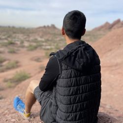
My first official trail hike in Arizona. I am not an outdoorsy person so my review is a bit partial, but this was a lot of fun. 2+ miles to the peak with elevation gain of 1100 feet. It is challenging climb but not terribly so. Going down is trickier for an inexperienced hiker like myself. There are few snakes here and we encountered one, but this could be a rare occurrence. Clean trail and no garbage. The view from the top is incredible!

Whew it's been a while since I've reviewed anything, thanks COVID-19. Anyways, hiking has been a bit difficult with social distancing but it's so nice to get out into nature. I like Sunrise trail, it's moderate but provides enough of a challenge to get a good workout in. It's beautiful and quiet, not much parking at the Trailhead but quite a bit in the overflow lot, which is a short walk away. This is not a shaded trail, so be aware and bring water and wear sunscreen. The McDowell Sonoran Preserve is well maintained and this site is no exception. Water fountains available but no bathrooms here. On my most recent hike, we saw a deer of sorts! Beautiful creature, thought it was a large plastic bag initially haha. I would suggest hiking early in the summer, we began around 6:10am and ended after 8am. It was hot, but this trail provides relief with some wind and some shady areas. Would recommend!

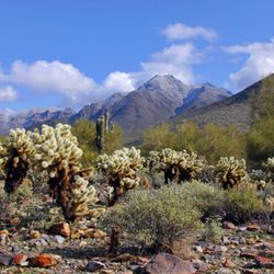
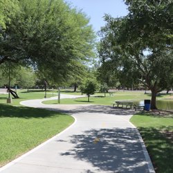
I like to hike here a lot as this is probably the closest yet still gives me the workout I need. It is 2 miles one way to the peak, and sign is there to tell you when you are at 1.2 miles and 0.2 miles to the peak. Trails are mostly sand and gravel, make it easy hike. My daughter was four when she first made the hike to the peak without being carried. I like to get there shortly before sunrise to enjoy the view of rising sun. I stop to look back to enjoy the sunrise. 360 degree of panoramic view from the peak is so beautiful. Enjoy the Scottsdale and Fountain Hills area view. the Fountain goes up every hour on the o'clock, so I like to time myself to be at the peak when the fountain goes up at the Fountain Park in the town of the Fountain Hills. The Year-around tallest fountain doesn't go up if wind is too strong. Easy hike for me as I hike almost every week, but like any other desert outing, I always bring plenty of water with me. Wearing good pair of shoes help as it is easy to slip on gravel when descending. Parking is limited. But they do have overflow parking just down the street.


This is my favorite hike in Arizona. Every time I hike the trail, I love it more. It has beautiful view the entire hike. Huge saguaro cacti, well made trail to follow, and overall the hike isn't too easy or too difficult. There's usually other people hiking but it's never crowded. It's a good trail for dogs too.

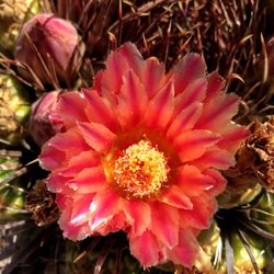
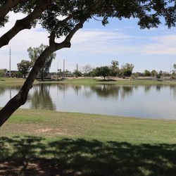
Easy to get there, very beautiful trails and magnificent views. I like it because is not to crowded. Parking is a bit limited, so if you can carpool its the best way to do it. No toilet in the entrance, but there are drinking water fountains for people and dogs. There are some wild poppies and lupine are in blooms right now (February). You can see the fountain hills from top, it's beautiful! I will definitely comeback when the cactus are in blooms, I wonder what month it will be since I'm new in This area.

What a gorgeous trail! Beautiful views. Clean and well maintained. There is a parking lot at the trail head with water fountains and maps. This hike kicked my ass. It's uphill til you get to the top of the mountain (I mean duh but it was still surprisingly difficult for me). You're basically climbing stairs for 2+ miles til you get to the top. Took us about 2 hours. A GREAT work out though! The whole time I was just thinking "thighs and glutes, thighs and glutes!"

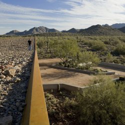
NO BATHROOM AT TRAIL! PEE BEFOREHAND (or behind a cactus...like I had to...). Awesome switchback trail. And it wasn't crowded at all. There were maybe 10 people at the top when we arrived, but only ran into 2-3 heading up. Since it's a switchback (zig-zag pattern), the trail is on a consistent gradient making it manageable for any fitness level. Some parts might have you breathing heavy but this trail isnt occupied like Camelback, so you won't be in anyone's way if you decide to break. The last .25 miles to the peak is steeper than the rest, but don't give up, the view is awesome! Lots of loose rocks on trail so wear good hiking shoes.

This is one of my favorite trails to hike, hands down!! It's been a while since I be been up this trail and in mad at myself for letting it escape me for so long. Tucked away and secluded...well groomed and not overcrowded...challenging enough to consider it a workout but still able to be enjoyed by kids and dogs...and not to mention it has some INCREDIBLE views and scenery. Excellent trail to say the very least!

Mountains are to me a cleanse for the soul.This trail was a 1100 gain off of 145 th in Scottsdale. We were lucky enough to discover this trail after meeting a Scottsdale local who recommended it. We found parking at the entrance although there is parking down the mountain another 500 feet away from this one if full. Even though it was 56 degrees at the start it can get warm as the trails are a moderate climb in parts but with good trail shoes and balance you most likely would not need hiking poles . The views from different points are worth a view and we were lucky to go early on a Saturday where the trails were not crowded. It was dog friendly and clean.No facilities so definitely need to bring water or drink of choice. Return: definitely for the views read more


A lovely hike. It has some elevation gain but is not overwhelming. There is also a lovely false peak a bit over a mile from the top which is a nice rest or place to stay as the rest of your party does the last bit of the hike. Lots of cute desert plants as well! read more


8 months ago


3 years ago
What a beautiful thanksgiving day hike!! Hope you have an awesome day with your loved ones! Total mileage 4.64. Not too far RT, however we went up to sunrise peak and so it continues to gain elevation. It was definitely some good exercise! If you're not hiking regularly or in good shape like the folks I saw trail running, your legs will hurt. Mine sure do! I haven't been hiking much lately lol. There are lots of rocky areas and you need to pay attention. I like hikes that I can space out and lose myself in nature but this hike requires you watch your footing more than the scenery, so not my favorite thing. However there are many great views to stop and take in the sights. - we completed our hike in 2.5 hrs including breaks and having a snack on the peak - dogs allowed - parking lots available x2 - people were friendly - no trash found, trail is clean and clearly marked read more


1 year ago
First day I went closer to sunset and signs were posted that the parking lot closes at 530pm I belive. So I only went up half way bc I didn't want to get locked in. The next morning I went up a little after sunrise and it was a great hike with lots of views. Definitely very windy so be prepared read more

My first official trail hike in Arizona. I am not an outdoorsy person so my review is a bit partial, but this was a lot of fun. 2+ miles to the peak with elevation gain of 1100 feet. It is challenging climb but not terribly so. Going down is trickier for an inexperienced hiker like myself. There are few snakes here and we encountered one, but this could be a rare occurrence. Clean trail and no garbage. The view from the top is incredible! read more


Whew it's been a while since I've reviewed anything, thanks COVID-19. Anyways, hiking has been a bit difficult with social distancing but it's so nice to get out into nature. I like Sunrise trail, it's moderate but provides enough of a challenge to get a good workout in. It's beautiful and quiet, not much parking at the Trailhead but quite a bit in the overflow lot, which is a short walk away. This is not a shaded trail, so be aware and bring water and wear sunscreen. The McDowell Sonoran Preserve is well maintained and this site is no exception. Water fountains available but no bathrooms here. On my most recent hike, we saw a deer of sorts! Beautiful creature, thought it was a large plastic bag initially haha. I would suggest hiking early in the summer, we began around 6:10am and ended after 8am. It was hot, but this trail provides relief with some wind and some shady areas. Would recommend! read more

 - Hiking Near Me - Scottsdale, Arizona")

2 years ago
I like to hike here a lot as this is probably the closest yet still gives me the workout I need. It is 2 miles one way to the peak, and sign is there to tell you when you are at 1.2 miles and 0.2 miles to the peak. Trails are mostly sand and gravel, make it easy hike. My daughter was four when she first made the hike to the peak without being carried. I like to get there shortly before sunrise to enjoy the view of rising sun. I stop to look back to enjoy the sunrise. 360 degree of panoramic view from the peak is so beautiful. Enjoy the Scottsdale and Fountain Hills area view. the Fountain goes up every hour on the o'clock, so I like to time myself to be at the peak when the fountain goes up at the Fountain Park in the town of the Fountain Hills. The Year-around tallest fountain doesn't go up if wind is too strong. Easy hike for me as I hike almost every week, but like any other desert outing, I always bring plenty of water with me. Wearing good pair of shoes help as it is easy to slip on gravel when descending. Parking is limited. But they do have overflow parking just down the street. read more

7 years ago


Can you see houses and the freeway from here? Yes. Although less than ideal when hiking it's still a great challenging hike to the summit. It does offer a spectacular view of the entire Phoenix valley. There are technical sections of the trail so be prepared. read more


7 years ago
This is my favorite hike in Arizona. Every time I hike the trail, I love it more. It has beautiful view the entire hike. Huge saguaro cacti, well made trail to follow, and overall the hike isn't too easy or too difficult. There's usually other people hiking but it's never crowded. It's a good trail for dogs too. read more


Easy to get there, very beautiful trails and magnificent views. I like it because is not to crowded. Parking is a bit limited, so if you can carpool its the best way to do it. No toilet in the entrance, but there are drinking water fountains for people and dogs. There are some wild poppies and lupine are in blooms right now (February). You can see the fountain hills from top, it's beautiful! I will definitely comeback when the cactus are in blooms, I wonder what month it will be since I'm new in This area. read more


8 years ago
What a gorgeous trail! Beautiful views. Clean and well maintained. There is a parking lot at the trail head with water fountains and maps. This hike kicked my ass. It's uphill til you get to the top of the mountain (I mean duh but it was still surprisingly difficult for me). You're basically climbing stairs for 2+ miles til you get to the top. Took us about 2 hours. A GREAT work out though! The whole time I was just thinking "thighs and glutes, thighs and glutes!" read more

NO BATHROOM AT TRAIL! PEE BEFOREHAND (or behind a cactus...like I had to...). Awesome switchback trail. And it wasn't crowded at all. There were maybe 10 people at the top when we arrived, but only ran into 2-3 heading up. Since it's a switchback (zig-zag pattern), the trail is on a consistent gradient making it manageable for any fitness level. Some parts might have you breathing heavy but this trail isnt occupied like Camelback, so you won't be in anyone's way if you decide to break. The last .25 miles to the peak is steeper than the rest, but don't give up, the view is awesome! Lots of loose rocks on trail so wear good hiking shoes. read more


11 years ago
This is one of my favorite trails to hike, hands down!! It's been a while since I be been up this trail and in mad at myself for letting it escape me for so long. Tucked away and secluded...well groomed and not overcrowded...challenging enough to consider it a workout but still able to be enjoyed by kids and dogs...and not to mention it has some INCREDIBLE views and scenery. Excellent trail to say the very least! read more


10 years ago
Really like this trail, a challenging trail not for the weak of leg. Started our climb at 9am and took us an hour to hike to the peak. Water fountain located at the bottom of the hill as well as dog waste bags. Great views of Phoenix with little areas to rest on the way up. I got quite upset at people walking their dogs in the heat. Dog owners I can't stress this enough, don't walk your dogs when it's above 74F it's cruel for your dog! If you insist on brining your dog up this mountain do it early in the morning when it's a lot cooler and make sure to bring lots of water. I'd like to see some of these dog owners walk bare foot up this mountain with a fur coat on in 80 degree weather... Sorry for my rant, great hike and I highly recommend. I am from Canada so this was a great way to see Phoenix from high up. read more

4 years ago
6 years ago
10 years ago
This trailhead is a hidden gem! I almost don't want to write about it so it wont get too crowded. It's classified as a moderate hike which I would agree with. Easier than Camelback or Piestewa and way less crowded. The trails are very groomed and are mostly sand, no loose rocks which is great for trail running. Being that this is out of the city, it seems to be a bit greener and a nice change from all the brown hiking trails in Phoenix. You also get some awesome views, if you time it right you can see the fountain in Fountain Hills going off. The hike is about 4 miles round trip with very few switchbacks making for a moderate but good workout. read more

11 years ago
Great hike. 2 miles to the trailhead. Easy access to the trailhead with plenty of parking spaces. They have a few water fountains at the trailhead including a dog fountain. read more


7 years ago
8 years ago
7 years ago
9 years ago
10 years ago
9 years ago
More info about Sunrise Trailhead
12101 N 145th Way 1
Scottsdale, AZ 85259
Directions
Hours
Indoor Amenities
Outdoor Amenities
Ask the Community - Sunrise Trailhead
For someone with limited mobility, can I can get some good views without going far from the parking area?
Absolutely. You can right in front and they have benches to sit if do not want to hike up
Review Highlights - Sunrise Trailhead


Why does Yelp recommend reviews?
Sunrise Trailhead - hiking - Updated May 2026
Best of Scottsdale
People found Sunrise Trailhead by searching for…
Scenic Overlook in Scottsdale, AZ
Paved Walking Trails in Scottsdale, AZ
Watch Sunset in Scottsdale, AZ
Hiking Trails in Scottsdale, AZ
Sunrise View in Scottsdale, AZ
Stairs Workout in Scottsdale, AZ
Running Trails in Scottsdale, AZ
Things to Do in Scottsdale, AZ
Places to Take Pictures in Scottsdale, AZ
Places to Walk at Night in Scottsdale, AZ
Beautiful Views in Scottsdale, AZ
Off Road Trails in Scottsdale, AZ
Secluded Spots in Scottsdale, AZ
Places to Walk in Scottsdale, AZ
Stair Climbing in Scottsdale, AZ
Lookout Points in Scottsdale, AZ
Trending Searches in Scottsdale, AZ
Botanical Gardens near Sunrise Trailhead
Bounce House Rentals near Sunrise Trailhead
Campgrounds near Sunrise Trailhead
Cheap Plants near Sunrise Trailhead
Cherry Picking near Sunrise Trailhead
Cliff Jumping near Sunrise Trailhead
Dog Friendly Things To Do near Sunrise Trailhead
Flower Fields near Sunrise Trailhead
Flower Shop near Sunrise Trailhead
Garage Sales near Sunrise Trailhead
Garden Center near Sunrise Trailhead
Lakes & Ponds near Sunrise Trailhead
Nurseries & Gardening near Sunrise Trailhead
Outdoor Activities near Sunrise Trailhead
Outdoor Furniture Stores near Sunrise Trailhead
Party Equipment Rentals near Sunrise Trailhead
Pedicure near Sunrise Trailhead
Photo Spots near Sunrise Trailhead
Picnic Areas near Sunrise Trailhead
Places To Take Pictures near Sunrise Trailhead
Rock Quarry near Sunrise Trailhead
Running Trails near Sunrise Trailhead
Rv Rental near Sunrise Trailhead
Spray Tanning near Sunrise Trailhead
Sunrise View near Sunrise Trailhead
Swimming Holes near Sunrise Trailhead
Table And Chair Rentals near Sunrise Trailhead
Browse Articles
Browse Nearby
BEST of Scottsdale, Arizona Coffee near Sunrise Trailhead
BEST of Scottsdale, Arizona Restaurants near Sunrise Trailhead
BEST of Scottsdale, Arizona Things to Do near Sunrise Trailhead
BEST of Scottsdale, Arizona Parks near Sunrise Trailhead
BEST of Scottsdale, Arizona Breakfast near Sunrise Trailhead
BEST of Scottsdale, Arizona Botanical Gardens near Sunrise Trailhead
Browse Brands
Related Searches in Scottsdale, AZ
Affordable Kayak Rental Services in Scottsdale, Arizona
Best Fishing Locations and Guides in Scottsdale, Arizona
Best Nature Trails for Hiking in Scottsdale, Arizona
Best Places for Horseback Riding in Scottsdale, Arizona
Best Waterfalls and Swimming Holes in Scottsdale, Arizona
Check Out Off Road Trails in Scottsdale, Arizona
Discover Dog Friendly Trails to Explore in Scottsdale, Arizona
Discover Scenic Mountain Bike Trails Near Scottsdale, Arizona
Discover Scenic Waterfall Spots in Scottsdale, Arizona
Discover Top Nature Parks to Visit in Scottsdale, Arizona
Discover Walking Parks in Scottsdale, Arizona Near You
Discover the Best Night Hike Trails in Scottsdale, Arizona
Discover the Best Running Track in Scottsdale, Arizona
Enjoy Camping Adventures Around Scottsdale, Arizona
Enjoy Exciting Mountain Biking Adventures in Scottsdale, Arizona
Enjoy Kayaking Adventures in Scottsdale, Arizona
Enjoy River Tubing Adventures in Scottsdale, Arizona
Enjoy Tent Camping Spots Around Scottsdale, Arizona
Enjoy a Beautiful Waterfall Hike in Scottsdale, Arizona
Enjoy the Best Walking Path in Scottsdale, Arizona
Enjoy the Best Walking Trails in Scottsdale, Arizona
Exciting Cliff Jumping Spots in Scottsdale, Arizona
Experience Thrilling White Water Rafting in Scottsdale, Arizona
Explore Beautiful Parks and Green Spaces in Scottsdale, Arizona
Explore Easy Hikes Perfect for All in Scottsdale, Arizona
Explore Fun Activities to Do in Scottsdale, Arizona
Explore Popular Campgrounds Near Scottsdale, Arizona
Explore the Best Beach Spots in Scottsdale, Arizona
Explore the Best Boating Spots in Scottsdale, Arizona
Explore the Best Trail Options in Scottsdale, Arizona
Family Friendly Hiking With Kids in Scottsdale, Arizona
Find Beautiful Views in Scottsdale, Arizona
Find Cozy Camping Cabins in Scottsdale, Arizona
Find the Best Parks for Picnics in Scottsdale, Arizona
Find the Best Scenic View Locations in Scottsdale, Arizona
Great Places to Walk in Scottsdale, Arizona
Hiking Trails With Waterfalls in Scottsdale, Arizona
Off Leash Dog Hiking Trails in Scottsdale, Arizona
Plan a Scenic Drive Route Near Scottsdale, Arizona
Popular Fishing Spots to Explore in Scottsdale, Arizona
Popular Outdoor Activities to Try in Scottsdale, Arizona
Popular Picnic Spots to Visit in Scottsdale, Arizona
Safe River Swimming Areas in Scottsdale, Arizona
Safe and Fun Parks for Kids in Scottsdale, Arizona
Top Climbing Spots and Gyms in Scottsdale, Arizona
Top Running Trails to Explore in Scottsdale, Arizona
Top Swimming Lakes to Enjoy in Scottsdale, Arizona
Top Swimming Spots and Pools in Scottsdale, Arizona
People who viewed Sunrise Trailhead also viewed
Camelback Mountain
760 reviews
Blue Wash Trail
7 reviews
Hole-in-the-Rock
383 reviews
Piestewa Peak
308 reviews
Adero Canyon Trailhead
6 reviews
Jewel Of The Creek
8 reviews
Granite Mountain Trailhead
11 reviews
Apache Wash Trailhead
31 reviews
Boulder Canyon Trail - Superstition Mountain
17 reviews
Advantage Grand Canyon
22 reviews