Railroad Pass Loop Photos


You might also consider
More like Railroad Pass Loop
Recommended Reviews - Railroad Pass Loop
Start your review...

3 years ago
One of my favorite hiking spots ! You can hit up downtown Boulder City in your way in or out. Either fuel up for your hike or after working up an appetite. I recommend Southwest Diner if the weather is good to sit outside. The hime is good for families, big groups or solo missions. It's mostly flat with lots of beautiful views. In the heat the tunnels allow for a break from the sun and there are cute seating areas for many picture opportunities. If you want a bit more exploration and exertion there are side trails and extensions you can take as well read more


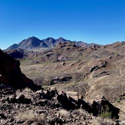
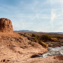
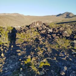
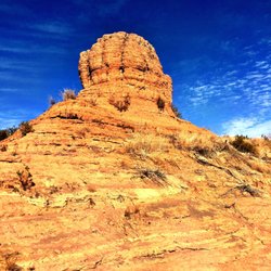
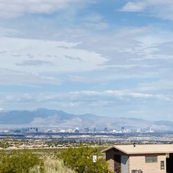
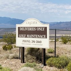
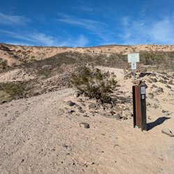
I've hiked this mountain bike trail twice in the last few weeks and it's a great hike with some challenging terrain. It is a 4.6 mile loop around the ridges behind the Railroad Pass Casino. You access this trail from the rear of the parking area at the Railroad Pass Casino just before Boulder City. At that rear parking area, you'll see a kiosk which has some interesting history of the area and the entrance to the River Mountain Loop Trail is there. Walk up to the paved trail and start heading for Boulder City. In about 20 feet, you'll notice a foot path going off to your left. Leave the bike/walking trail there and head toward the ridge. You'll soon cross the railroad tracks. Keep following this use trail and you soon arrive at the mountain bike trail. From there, the route is obvious for the first half of the hike. The hike follows the mountain bike trail as it loops around several ridges. After one of the ridges, after you make the turn east, you'll start to see the Cascata Golf Course owned by Caesars Entertainment. There a fence separating the bike trail from the private property. As you continue on the hike, you'll soon get a view of the driving range practice area and then you'll see the man made waterfall that was put in when MGM originally built the course. There are some areas of rough basalt rock and areas where the bikers have put some large boulders to fill in some of the washed out areas. There are some great views of the Eldorado Dry Lake bed area and you can see the solar power plants along US 95 heading toward Searchlight. About halfway into the hike, you come to a saddle. This is the highest point on the hike and you have a panoramic view of the Las Vegas Valley. You can see Mount Charleston in the Spring Mountains on the west side. This is a good place to take a break and have a snack. From here, it's basically all downhill. There are several trails here but if you follow the main trail and stay to your left when you come to a fork, you'll end up rounding the east side of the last ridge and the Railroad Pass Casino will come into sight. After the last turn behind the casino, walk down to the bike path, cross the railroad tracks again, and then follow and old road into the upper parking area where you left your car. Notes: This hike can be done with sneakers but it's always best to wear hiking boots on this kind of terrain for extra safety. Some of the scree in the down part is a bit slippery and boots serve you well. As with all hiking, take plenty of water with you. In my photos, I have included a route track on Google Earth from my GPS track. If you want the track for your GPS unit, send me a message! This is a fun hike with some great views. Happy hiking! read more


8 years ago
This loop had great views. There is a parking lot specially to access the paved path and the offshoot to the loop. We didn't find a well defined dirt path as we headed toward Blulder City and the first path we did attempt to take was occupied by a homeless encampment. In fact along our hike of the loop (as it sits above the casino, gas station) there were at least 4 separate homeless encampments in the rocks, hidden from the pavement below. As for the path as you head East, it is very cool. We saw at least 30 bighorn sheep. Some were in the hills and others we found having breakfast on the golf course. Overall, once you get away from the casino area, this is a pretty hike, but keep a watch out. read more


 of the parking lot - Hiking Near Me - Henderson, Nevada")
More info about Railroad Pass Loop
1500 Railroad Pass Casino Rd
Henderson, NV 89002
Directions
Hours
Outdoor Amenities


Railroad Pass Loop - hiking - Updated July 2026
Best of Henderson
People found Railroad Pass Loop by searching for…
Hiking Trails With Waterfalls in Henderson, Nevada
Dirt Bike Riding in Henderson, Nevada
Scenic Overlook in Henderson, Nevada
Scenic Drive in Henderson, Nevada
Walking Trails in Henderson, Nevada
Lookout Points in Henderson, Nevada
Places to Take Pictures in Henderson, Nevada
Wildflowers in Henderson, Nevada
Off Road Trails in Henderson, Nevada
Mountain Biking in Henderson, Nevada
Lakes & Ponds in Henderson, Nevada
Dinosaur Park in Henderson, Nevada
Stair Climbing in Henderson, Nevada
Hiking Club in Henderson, Nevada
Scenic View in Henderson, Nevada
Running Trails in Henderson, Nevada
Abandoned Places in Henderson, Nevada
Secret Spots in Henderson, Nevada
Easy Hikes in Henderson, Nevada
Waterfalls and Swimming Holes in Henderson, Nevada
Tourist Attractions in Henderson, Nevada
Trending Searches in Henderson, NV
4th Of July Fireworks near Railroad Pass Loop
Black Owned Nail Salons near Railroad Pass Loop
Boat Rental near Railroad Pass Loop
Cliff Jumping near Railroad Pass Loop
Day Trips near Railroad Pass Loop
Fireworks near Railroad Pass Loop
Jet Ski Rental near Railroad Pass Loop
Kayak Rental near Railroad Pass Loop
Lakes & Ponds near Railroad Pass Loop
Off Road Trails near Railroad Pass Loop
Outdoor Activities near Railroad Pass Loop
Parks For Picnics near Railroad Pass Loop
Places To Walk Around near Railroad Pass Loop
Public Pools near Railroad Pass Loop
Public Shower near Railroad Pass Loop
River Swimming near Railroad Pass Loop
Rock Quarry near Railroad Pass Loop
Scenic Night View near Railroad Pass Loop
Scenic Overlook near Railroad Pass Loop
Secluded Spots near Railroad Pass Loop
Soccer Store near Railroad Pass Loop
Splash Pad near Railroad Pass Loop
Strawberry Picking near Railroad Pass Loop
Sunrise View near Railroad Pass Loop
Swimming Holes near Railroad Pass Loop
Swimming Lakes near Railroad Pass Loop
Watch Sunset near Railroad Pass Loop
Browse Articles
Browse Nearby
BEST of Henderson, Nevada Things to Do near Railroad Pass Loop
BEST of Henderson, Nevada Coffee near Railroad Pass Loop
BEST of Henderson, Nevada Restaurants near Railroad Pass Loop
BEST of Henderson, Nevada Parks near Railroad Pass Loop
BEST of Henderson, Nevada Breakfast near Railroad Pass Loop
BEST of Henderson, Nevada Horseback Riding near Railroad Pass Loop
Browse Brands
Related Searches in Henderson, NV
Affordable Kayak Rental Services in Henderson, Nevada
Best Fishing Locations and Guides in Henderson, Nevada
Best Nature Trails for Hiking in Henderson, Nevada
Best Places for Horseback Riding in Henderson, Nevada
Check Out Off Road Trails in Henderson, Nevada
Discover Dog Friendly Trails to Explore in Henderson, Nevada
Discover Scenic Mountain Bike Trails Near Henderson, Nevada
Discover Top Nature Parks to Visit in Henderson, Nevada
Discover Walking Parks in Henderson, Nevada Near You
Discover a Hiking Trail in Henderson, Nevada
Discover the Best Night Hike Trails in Henderson, Nevada
Discover the Best Running Track in Henderson, Nevada
Dog-Friendly Hikes With Dogs in Henderson, Nevada
Enjoy Camping Adventures Around Henderson, Nevada
Enjoy Exciting Mountain Biking Adventures in Henderson, Nevada
Enjoy Kayaking Adventures in Henderson, Nevada
Enjoy Tent Camping Spots Around Henderson, Nevada
Enjoy the Best Walking Path in Henderson, Nevada
Enjoy the Best Walking Trails in Henderson, Nevada
Exciting Cliff Jumping Spots in Henderson, Nevada
Explore Beautiful Parks and Green Spaces in Henderson, Nevada
Explore Easy Hikes Perfect for All in Henderson, Nevada
Explore Fun Activities to Do in Henderson, Nevada
Explore Popular Campgrounds Near Henderson, Nevada
Explore the Best Beach Spots in Henderson, Nevada
Explore the Best Boating Spots in Henderson, Nevada
Explore the Best Swimming Holes Around Henderson, Nevada
Explore the Best Trail Options in Henderson, Nevada
Family Friendly Hiking With Kids in Henderson, Nevada
Find Beautiful Views in Henderson, Nevada
Find Popular Ziplining Spots Around Henderson, Nevada
Find the Best Parks for Picnics in Henderson, Nevada
Find the Best Scenic View Locations in Henderson, Nevada
Great Places to Walk in Henderson, Nevada
Hiking Trails With Waterfalls in Henderson, Nevada
Off Leash Dog Hiking Trails in Henderson, Nevada
Plan a Scenic Drive Route Near Henderson, Nevada
Popular Fishing Spots to Explore in Henderson, Nevada
Popular Outdoor Activities to Try in Henderson, Nevada
Popular Picnic Spots to Visit in Henderson, Nevada
Safe River Swimming Areas in Henderson, Nevada
Safe and Fun Parks for Kids in Henderson, Nevada
Top Climbing Spots and Gyms in Henderson, Nevada
Top Paddleboarding Activities in Henderson, Nevada
Top Running Trails to Explore in Henderson, Nevada
Top Swimming Lakes to Enjoy in Henderson, Nevada
Top Swimming Spots and Pools in Henderson, Nevada
Top Things to Do With Kids in Henderson, Nevada
People who viewed Railroad Pass Loop also viewed
Historic Railroad Trail
170 reviews
Pittman Wash Trail
43 reviews
Amargosa Trail
26 reviews
White Owl Canyon
23 reviews
St. Rose Parkway Trail
16 reviews
Anthem, Southeast
Anthem East Trail
21 reviews
Liberty Bell Arch
22 reviews
Union Pacific Railroad Trail
10 reviews
Park Peak Trail 403
4 reviews
Red and Black Mountain
3 reviews